Rhode Island Avenue (Washington, D.C.)

Last updated
Rhode Island Avenue
Other name(s) Rhode Island Avenue NW
Rhode Island Avenue NE
Maintained by DDOT
Location Washington, D.C., U.S.
Coordinates 38°55′14.65″N76°59′52.15″W / 38.9207361°N 76.9978194°W / 38.9207361; -76.9978194 Coordinates: 38°55′14.65″N76°59′52.15″W / 38.9207361°N 76.9978194°W / 38.9207361; -76.9978194
West end Connecticut Avenue
Major
junctions
Scott Circle
Logan Circle
7th Street  / Georgia Avenue
Florida Avenue
North Capitol Street
East endUS 1.svg US 1 (Rhode Island Avenue)

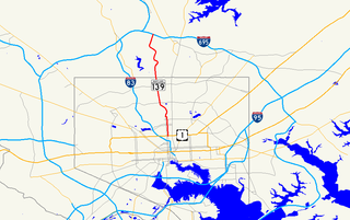
Rhode Island Avenue is a diagonal avenue in the Northwest and Northeast quadrants of Washington, D.C. and the capital's inner suburbs in Prince George's County, Maryland. Paralleling New York Avenue, Rhode Island Avenue was one of the original streets in Pierre L'Enfant's plan for the capital. Today it is a major commuter route, carrying U.S. Route 1 traffic into the city from Prince George's County.

Washington, D.C. Capital of the United States

Washington, D.C., formally the District of Columbia and commonly referred to as Washington or D.C., is the capital of the United States. Founded after the American Revolution as the seat of government of the newly independent country, Washington was named after George Washington, the first President of the United States and a Founding Father. As the seat of the United States federal government and several international organizations, Washington is an important world political capital. The city is also one of the most visited cities in the world, with more than 20 million tourists annually.

Prince Georges County, Maryland County in the United States

Prince George's County is a county in the U.S. state of Maryland, bordering the eastern portion of Washington, D.C. As of the 2010 U.S. Census, the population was 863,420, making it the second-most populous county in Maryland, behind only Montgomery County. Its county seat is Upper Marlboro. It is one of the richest African American-majority counties in the United States, with five of its communities identified in a 2015 top ten list.

New York Avenue (Washington, D.C.) street in Washington, D.C.

New York Avenue is diagonal avenue radiating northeast from the White House in Washington, D.C., to the border with Maryland. It is a major east–west route in the city's Northwest and Northeast quadrants and connects downtown with points east and north of the city via Cheverly, Maryland, the John Hanson Highway, the Baltimore-Washington Parkway, and eventually Interstate 95.

The western terminus of Rhode Island Avenue is in downtown Washington, at an intersection with Connecticut Avenue and M Street, N.W. The Cathedral of St. Matthew the Apostle is on Rhode Island Avenue, just east of that intersection. Just east of the cathedral, at Scott Circle, Rhode Island Avenue intersects Massachusetts Avenue and 16th Street, N.W. N Street stops short of meeting the circle from either direction, but is instead connected to Rhode Island and Massachusetts avenues through two short streets, Corregidor Street and Bataan Street. From Scott Circle, Rhode Island Avenue continues eastward to the Logan Circle neighborhood. At the traffic circle of the same name, Rhode Island Avenue intersects Vermont Avenue, 13th Street, and P Street, N.W.

Connecticut Avenue major thoroughfare in Northwest quadrant of Washington, D.C.; continues in Montgomery County, Maryland, United States

Connecticut Avenue is a major thoroughfare in the Northwest quadrant of Washington, D.C., and suburban Montgomery County, Maryland. It is one of the diagonal avenues radiating from the White House, and the segment south of Florida Avenue was one of the original streets in Pierre (Peter) Charles L'Enfant's's plan for Washington.

Scott Circle traffic circle in Washington, D.C.

Scott Circle is a traffic circle in the northwest quadrant of Washington, D.C., at the junction of Massachusetts Avenue, Rhode Island Avenue, and 16th Street, N.W. N Street stops short of meeting the circle from either direction, and is connected to Rhode Island and Massachusetts avenues through Corregidor Street and Bataan Street.

East of Logan Circle, Rhode Island passes through primarily residential neighborhoods such as Bloomingdale, Shaw and Brentwood. Rhode Island Avenue is U.S. Route 29 between 7th and 11th streets, N.W., and U.S. Route 1 east of 6th Street, N.W. In Northeast Washington, Rhode Island Avenue is served by the Rhode Island Ave-Brentwood station on the Red Line and the Shaw-Howard University station on the Green Line of the Washington Metro.

U.S. Route 29 (US 29) in the District of Columbia is a U.S. highway which enters D.C. via Key Bridge from Arlington, Virginia, and exits at Silver Spring, Maryland. It predominantly follows city surface streets, although the portion of the route from Key Bridge east to 26th Street NW is an elevated highway. The elevated section of U.S. Route 29 in D.C. is better known as the Whitehurst Freeway. Called the city's most ridiculed bridge in 1989, there have been several attempts to have the Whitehurst Freeway torn down but cost and other considerations have stopped these proposals from being acted on.

7th Street (Washington, D.C.) street in Washington, D.C.

There are two north-south arteries in Washington, D.C. named 7th Street that are differentiated by the quadrants of the city in which they are located. Historically, 7th Street has been a main north-south road in Washington, being the main route for travelers and farmers coming into the city from the north. This is evident in its intersection with Mount Vernon Square, a historically important public space, as well as the original Central Market, located at the intersection of Seventh, Pennsylvania, and Indiana Avenues. The space occupied by this Central Market has now become the location of the Navy Memorial. Seventh Street forms major intersections at Pennsylvania Ave, E Street NW, H Street NW, K Street NW, and Massachusetts Avenue.

Within the District of Columbia, U.S. Route 1 passes between Arlington, Virginia and Mount Rainier, Maryland predominantly along surface streets. However, it forms a few overlaps with other routes.

In 1926, Rhode Island Avenue was extended from the District line through Mount Rainier, Brentwood, and North Brentwood. [1]

Mount Rainier, Maryland City in Maryland

Mount Rainier is a city in Prince George's County, Maryland, United States, bordering Washington D.C. The population was 8,080 at the 2010 census. Mount Rainier is contained between the Northwest Branch Anacostia River, Cedar Lane Alley, and 34th Street to the north, 37th Street and 37th Place to the northeast, Upshur Street and Queens Chapel Road to the west, the Cargo Train/ the former 82 Streetcar tracks to the east, and Eastern Avenue NE to the south. Mount Rainier got its start as a streetcar suburb. According to local tradition, surveyors from the Pacific Northwest named the town, giving the streets names such as "Shasta" and "Cascade". Historic U.S. 1 runs through the center of the town and serves as the main street and central business district.

Brentwood, Maryland Town in Maryland, United States

Brentwood is a town in Prince George's County, Maryland, United States. The population was 3,046 at the 2010 census. Brentwood is less than 1-mile (1.6 km) away from Washington, D.C. The municipality of Brentwood is located just outside the northeast boundary of the District of Columbia and surrounded by the communities of Mount Rainier, Cottage City, North Brentwood, and the nearby Hyattsville. Along the Route 1 Corridor, Brentwood is part of the Gateway Arts District.

North Brentwood, Maryland Town in Maryland

North Brentwood is a town in Prince George's County, Maryland, United States. The population was 517 at the 2010 census. The municipality of North Brentwood is located north of Washington, D.C., and is surrounded by the communities of Brentwood, Hyattsville, and Cottage City, and the nearby Mount Rainier. The Town of North Brentwood was incorporated in 1924, and was the first African-American-majority municipality in Maryland. Along the Route 1 Corridor, North Brentwood is part of the Gateway Arts District.

In downtown Hyattsville, Rhode Island Avenue merges into Baltimore Avenue (U.S. Highway 1 Alternate). U.S. Highway 1 traffic continues north on Baltimore Avenue. Discontinuous segments of Rhode Island Avenue exist in Riverdale Park, College Park, and Beltsville.

Hyattsville, Maryland City in Maryland

Hyattsville is a city in Prince George's County, Maryland, and also a close, urban suburb of Washington, D.C. The population was 17,557 at the 2010 United States Census.

Riverdale Park, Maryland Town in Maryland

Riverdale Park, formerly known and often referred to as Riverdale, Maryland is a semi-urban town in Prince George's County, Maryland, United States, a suburb in the Washington D.C. metropolitan area. The population was 6,956 as of 2010.

College Park, Maryland City in Maryland, United States

The City of College Park is in Prince George's County, Maryland, United States, and is about 4 miles (6.4 km) from the northeast border of Washington, D.C. The population was 30,413 at the 2010 United States Census. It is best known as the home of the University of Maryland, College Park, and since 1994 the city has also been home to the National Archives at College Park, a facility of the U.S. National Archives, as well as to the National Oceanic and Atmospheric Administration (NOAA) Center for Weather and Climate Prediction (NCWCP).

Related Research Articles

New Jersey Route 28 highway in New Jersey

Route 28 is a state highway in the central part of New Jersey, United States that is 26.44 mi (42.55 km) long. Its western terminus is at U.S. Route 22 in Bridgewater Township, Somerset County while its eastern terminus is at Route 27 in Elizabeth, Union County. From its western terminus, Route 28 heads east through Raritan, intersecting County Route 567 and then U.S. Route 202 and U.S. Route 206 at the Somerville Circle before heading through the central part of Somerville. Past Somerville, the route interchanges with Interstate 287 in Bridgewater Township before intersecting many 500-series county roads including County Route 525 and County Route 527 in Bound Brook, County Route 529 in Dunellen, Middlesex County, County Route 531 in Plainfield, Union County, and County Route 509 in Westfield. Route 28 continues east, intersecting Route 59 and the Garden State Parkway in Cranford before heading to Elizabeth, where it crosses Route 439 before ending at Route 27. Route 28 is a two- to four-lane road its entire length that passes through suburban areas and runs within a close distance of New Jersey Transit’s Raritan Valley Line for much of its length.

Rhode Island Avenue–Brentwood station Washington Metro station on the Red line

Rhode Island Avenue is a Washington Metro station in Washington, D.C. on the Red Line. The station is located in the Brentwood neighborhood of Northeast, Washington, D.C., on an elevated platform crossing Rhode Island Avenue N.E..

U.S. Route 240 is a defunct designation for a short, but once very important, segment of highway between Frederick, Maryland and Washington, D.C.

Euclid Avenue (Cleveland) street in Ohio, United States of America

Euclid Avenue is a major street in Cleveland, Ohio. It runs northeasterly from Public Square in Downtown Cleveland, through the cities of East Cleveland, Euclid and Wickliffe, to the suburb of Willoughby as a part of U.S. Route 20 and U.S. Route 6. The street passes Playhouse Square, University Circle, Cleveland State University, the Cleveland Clinic, Severance Hall, Case Western Reserve University’s Maltz Performing Arts Center, Case Western Reserve University and University Hospitals Case Medical Center. The HealthLine bus rapid transit line runs in designated bus lanes in the median of Euclid Avenue from Public Square to Louis Stokes Station at Windermere in East Cleveland.

14th Street (Washington, D.C.) street in northwest and southwest quadrants of Washington, D.C., USA

14th Street NW/SW is a street in Northwest and Southwest quadrants of Washington, D.C., located 1.25 miles (2.01 km) west of the U.S. Capitol. It runs from the 14th Street Bridge north to Eastern Avenue.

Massachusetts Avenue (Washington, D.C.) major diagonal transverse road in Washington, D.C.

Massachusetts Avenue is a major diagonal transverse road in Washington, D.C., and the Massachusetts Avenue Historic District is a historic district that includes part of it.

Wisconsin Avenue major thoroughfare in Washington, D.C., and its Maryland suburbs, United States

Wisconsin Avenue is a major thoroughfare in Washington, D.C., and its Maryland suburbs. It starts in Georgetown just north of the Potomac River, at an intersection with K Street under the Whitehurst Freeway. The section of Wisconsin Avenue in Georgetown was called High Street before the street names in Georgetown were changed in 1895 to conform to those of the L'Enfant plan for the federal city.

The name "M Street" refers to two major roads in the United States capital of Washington, D.C. Because of the Cartesian coordinate system used to name streets in Washington, the name "M Street" can be used to refer to any east-west street located twelve blocks north or south of the dome of the United States Capitol. Thus, in all four quadrants of the city there are streets called "M Street", which are disambiguated by quadrant designations, namely, M Street NW, NE, SW, and SE.

Maryland Route 384 southernmost portion of Colesville Road in Silver Spring, Maryland, United States

Maryland Route 384 is a state highway in the U.S. state of Maryland. The highway runs 0.53 miles (0.85 km) from MD 390 east to U.S. Route 29 and MD 97 within Silver Spring. MD 384 is a six-lane divided highway that forms the southernmost portion of Colesville Road, a major commuting route and one of the two main streets, with Georgia Avenue, within downtown Silver Spring, the commercial hub of southeastern Montgomery County. The state highway also provides access to the Silver Spring station of the Washington Metro, which serves as a transit hub for commuter rail and bus service for the surrounding area. MD 384 and its railroad underpass were constructed in the late 1920s. The highway was expanded to a divided highway in the mid-1970s.

Charles Street (Baltimore) highway in Maryland

Charles Street, known for most of its route as Maryland Route 139, runs through Baltimore City and through the Towson area of Baltimore County. On the north end it terminates at an intersection with Bellona Avenue near Interstate 695 and at the south end it terminates in Federal Hill in Baltimore. Charles Street is one of the major routes through the city of Baltimore, and is a major public transportation corridor. For the one-way portions of Charles Street, the street is functionally complemented by the parallel St. Paul Street, Maryland Avenue, Cathedral Street, and Liberty Street.

County Route 502 (New Jersey) highway in New Jersey

County Route 502, abbreviated CR 502, is a county highway in the U.S. state of New Jersey. The highway extends 23.79 miles (38.29 km) from Paterson-Hamburg Turnpike (CR 504) in Wayne to Palisades Boulevard in Alpine.

U.S. Route 1 in Maryland highway in Maryland

U.S. Route 1 (US 1) is the easternmost and longest of the major north–south routes of the older 1920s era United States Numbered Highway System, running from Key West, Florida to Fort Kent, Maine. In the U.S. state of Maryland, an 80.86-mile (130.13 km) segment of the route runs through central Maryland between Mount Rainier and Rising Sun.

Northern Parkway is a major road that runs west–east across the northern part of the city Baltimore. For most of the way, it is at least six lanes wide, and it is used by motorists for crosstown travel. It is designated E. Northern Pkwy and W. Northern Pkwy with Charles Street being the dividing line. It was constructed in the 1950s through several neighborhoods and several homes were razed in the process from right-of-way. The section of E. Northern Pkwy from Harford Road to Fleetwood Ave was originally called German Lane.

Massachusetts Route 152 is a state highway in the U.S. state of Massachusetts. The highway begins at the Rhode Island state line, where the road continues into East Providence as Rhode Island Route 152 to U.S. Route 1A and Rhode Island Route 114. Route 152 runs 14.8821 miles (23.9504 km) through Seekonk, Attleboro, and North Attleboro to US 1 in Plainville.

Several special routes of U.S. Route 1 exist, from Florida to Maine. In order from south to north, separated by type, these special routes are as follows.

College Park Line

The College Park Line, designated Route 83, 83X, 86, is a daily bus route operated by the Washington Metropolitan Area Transit Authority between Rhode Island Avenue–Brentwood station of the Red Line of the Washington Metro and Cherry Hill Park Campground or Calverton (86). The line operates every 30 minutes during peak hours and late night when Route 83 is shortened to operate between Rhode Island Avenue–Brentwood Metro station and Mt. Rainer Terminal only, and 60 minutes all other times. Route 83 trips are 52 minutes between the Metro station and Cherry Hill Park Campground and 10 minutes between the station and Mt. Rainer Terminal while Route 86 is one hour and 12 minutes long. The seasonal 83X which operates between College Park–University of Maryland station and Cherry Hill Park Playground operates on the third Monday in June through the second Friday of August each year which takes 14 minutes. The routes provide direct service into Northwest DC from College Park and Cherry Hill/Calverton.

Rhode Island Avenue–New Carrollton Line

The Rhode Island Avenue-New Carrollton Line, designated Route T14, is a daily bus route operated by the Washington Metropolitan Area Transit Authority between New Carrollton station of the Orange Line of the Washington Metro and Rhode Island Avenue–Brentwood station of the Red Line of the Washington Metro. The line operates every 20-50 minutes on weekdays, and 60 minutes on the weekends. Route T14 trips roughly take 50 minutes.

References