U.S. Route 1 (US 1) is a major north–south U.S. Highway that serves the East Coast of the United States. It runs 2,369 miles (3,813 km), from Key West, Florida north to Fort Kent, Maine, at the Canada–US border, making it the longest north–south road in the United States. US 1 is generally paralleled by I-95, though the former is significantly farther west (inland) between Jacksonville, Florida, and Petersburg, Virginia. The highway connects most of the major cities of the East Coast—including Miami, Jacksonville, Richmond, Washington, D.C., Baltimore, Philadelphia, New York City, Boston and Portland, passing from the Southeastern United States to New England.

U.S. Route 395 is a U.S. Route in the western United States. The southern terminus of the route is in the Mojave Desert at Interstate 15 near Hesperia. The northern terminus is at the Canada–US border near Laurier, where the road becomes Highway 395 upon entering British Columbia, Canada. Before 1964, the route extended south to San Diego. I-15, I-215, and California State Route 163 replaced the stretch of 395 that ran from San Diego to Hesperia through Riverside and San Bernardino. "Old Highway 395" can be seen along or near I-15 in many locations before it branches off at Hesperia to head north.
U.S. Route 240 is a defunct designation for a short, but once very important, segment of highway between Frederick, Maryland and Washington, D.C.

Southwest is the southwestern quadrant of Washington, D.C., the capital of the United States, and is located south of the National Mall and west of South Capitol Street. It is the smallest quadrant of the city. Southwest is small enough that it is frequently referred to as a neighborhood in and of itself. However, it actually contains five separate neighborhoods.
Interstate 395 (I-395) in Washington, D.C., and Virginia is a 13.39-mile-long (21.55 km) spur route of Interstate 95 (I-95) that begins at an interchange with I-95 in Springfield and ends at an interchange with U.S. Route 50 in northwest Washington, D.C. It passes underneath the National Mall near the U.S. Capitol and ends at a junction with U.S. Route 50 at New York Avenue, roughly one mile (1.6 km) north of the 3rd Street Tunnel. Despite its proximity to I-395 in Maryland, the route is unrelated and unconnected.

Virginia Avenue is a street in the Northwest, Southwest, and Southeast quadrants of Washington, D.C. Like other state-named streets in Washington, it diagonally crosses the grid pattern formed by lettered (east-west) and numbered (north-south) streets.

Downtown Portland, the city center of Portland, Oregon, United States, is located on the west bank of the Willamette River. It is in the northeastern corner of the southwest section of the city and where most of the city's high-rise buildings are found.

Independence Avenue is a major east-west street in the southwest and southeast quadrants of the city of Washington, D.C., in the United States, running just south of the United States Capitol. Originally named South B Street, Independence Avenue SW was constructed between 1791 and 1823. Independence Avenue SE was constructed in pieces as residential development occurred east of the United States Capitol and east of the Anacostia River. Independence Avenue SW received its current name after Congress renamed the street in legislation approved on April 13, 1934. Independence Avenue SW originally had its western terminus at 14th Street SW, but was extended west to Ohio Drive SW between 1941 and 1942. The government of the District of Columbia renamed the portion of the road in the southeast quadrant of the city in 1950.
The name "M Street" refers to two major roads in the United States capital of Washington, D.C. Because of the Cartesian coordinate system used to name streets in Washington, the name "M Street" can be used to refer to any east-west street located twelve blocks north or south of the dome of the United States Capitol. Thus, in all four quadrants of the city there are streets called "M Street", which are disambiguated by quadrant designations, namely, M Street NW, NE, SW, and SE.
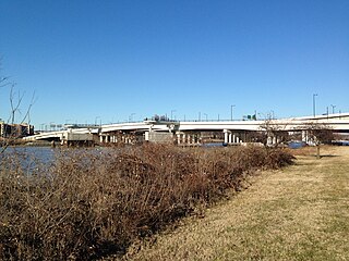
The 11th Street Bridges are a complex of three bridges across the Anacostia River in Washington, D.C., United States. The bridges convey Interstate 695 across the Anacostia to its southern terminus at Interstate 295 and DC 295. The bridges also connect the neighborhood of Anacostia with the rest of the city of Washington.
The Inner Loop was two planned freeways around downtown Washington, D.C. The innermost loop would have formed an oval centered on the White House, with a central freeway connecting the southern segment to the northern segment and then continuing on to Interstate 95. Interstate 95 would have met Interstate 66, Interstate 295, Interstate 695, and US 50 while traversing the Inner Loop. A second loop was an arc across the northern section of the city, beginning at East Capitol Street at the Anacostia River and using the Missouri Avenue NW and Nebraska Avenue NW commercial corridors to terminate in Georgetown.

Ohio Drive is a street in Southwest Washington, D.C., located in East and West Potomac Parks and bordering the Tidal Basin, Washington Channel, and the Potomac River. It is a central organizing feature of East Potomac Park, providing the only major vehicular route to and through the area. Unlike most roadways named after states in the District of Columbia, Ohio Drive is not an avenue, nor it is heavily used like Wisconsin or Rhode Island Avenues. However, the segment from Independence Avenue to the Rock Creek and Potomac Parkway is an important commuter route.
Interstate 95 (I-95) is an Interstate highway running from Miami, Florida, north to Houlton, Maine. In the U.S. state of Pennsylvania, it runs 44.25 miles (71.21 km) from the Delaware state line near Marcus Hook to the Delaware River–Turnpike Toll Bridge at the New Jersey state line. From the Delaware state line to exit 40, the route is known by many as the Delaware Expressway, but is officially named the Vietnam Veterans Memorial Highway. North(east) of exit 40, I-95 runs along the easternmost portion of the Pennsylvania Turnpike. I-95 parallels its namesake Delaware River for its entire route through the city of Philadelphia and its suburbs. It is a major route through the city and the metropolitan Delaware Valley, providing access to locally important landmarks such as Philadelphia International Airport, the South Philadelphia Sports Complex, Talen Energy Stadium, Penn's Landing, and Philadelphia Mills. Of the 15 states that Interstate 95 runs through, Pennsylvania is the only one that does not border the Atlantic Ocean.

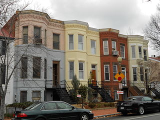
The Southwest Waterfront is a mostly residential neighborhood in Southwest Washington, D.C. The Southwest quadrant is the smallest of Washington's four quadrants, and the Southwest Waterfront is one of only two residential neighborhoods in the quadrant; the other is Bellevue, which, being east of the Anacostia River, is frequently, if mistakenly, regarded as being in Southeast. For that reason many residents of Southwest Waterfront will simply refer to themselves as living in "Southwest."

Southwest Federal Center is a business district in Southwest Washington, D.C., nearly entirely occupied by offices for various branches of the U.S. Government, including many of the museums of the Smithsonian Institution.
The 9th Street Expressway and the 12th Street Expressway are a pair of spurs connecting Interstate 395 with Downtown Washington, D.C.. The two carriageways are 0.2 miles (0.32 km) apart from each other, and gain their namesake from the roads that they lead into once reaching the downtown Federal Triangle neighborhood.