18th Street NW (Washington, D.C.)

Last updated
Shops along 18th Street NW in Adams Morgan neighborhood. Adamsmorgan2.jpg
Shops along 18th Street NW in Adams Morgan neighborhood.
18th Street in the Strivers' Section Historic District. 1800 block of 18th Street, NW.JPG
18th Street in the Strivers' Section Historic District.

18th Street Northwest is a prominent north–south street thoroughfare in the Northwest quadrant of Washington, D.C.

Street A public thoroughfare in a built environment

A street is a public thoroughfare in a built environment. It is a public parcel of land adjoining buildings in an urban context, on which people may freely assemble, interact, and move about. A street can be as simple as a level patch of dirt, but is more often paved with a hard, durable surface such as concrete, cobblestone or brick. Portions may also be smoothed with asphalt, embedded with rails, or otherwise prepared to accommodate non-pedestrian traffic.

Quadrants of Washington, D.C. geographical quadrant

Washington, D.C., is administratively divided into four geographical quadrants of unequal size, each delineated by their ordinal directions from the medallion located in the Crypt under the Rotunda of the Capitol. Street and number addressing, centered on the Capitol, radiates out into each of the quadrants, producing a number of intersections of identically named cross-streets in each quadrant. Originally, the District of Columbia was a near-perfect square. However, even then the Capitol was never located at the geographic center of the territory. As a result, the quadrants are of greatly varying size. Northwest is quite large, encompassing over a third of the city's geographical area, while Southwest is little more than a neighborhood and military base.

Contents

History

The "18th Street" roadway was part of the 1791 L'Enfant Plan for Washington by Pierre Charles L'Enfant.

LEnfant Plan

The L'Enfant Plan for the city of Washington is the urban plan developed in 1791 by Major Pierre (Peter) Charles L'Enfant for George Washington, the first President of the United States.

Pierre Charles L'Enfant, self-identified as Peter Charles L'Enfant while living in the United States, was a French-American military engineer who designed the basic plan for Washington, D.C. known today as the L'Enfant Plan (1791).

In the present day 18th Street also travels through downtown Washington and the Dupont Circle and Mount Pleasant neighborhoods. It is also one of the main streets in the Adams Morgan neighborhood; the other is Columbia Road.

Dupont Circle neighborhood in Washington, D.C.

Dupont Circle is a traffic circle, park, neighborhood, and historic district in Northwest Washington, D.C.. The Dupont Circle neighborhood is bounded approximately by 16th Street NW to the east, 22nd Street NW to the west, M Street NW to the south, and Florida Avenue NW to the north. Much of the neighborhood is listed on the National Register of Historic Places. However, the local government Advisory Neighborhood Commission and the Dupont Circle Historic District have slightly different boundaries.

Adams Morgan Place in the United States

Adams Morgan is a neighborhood in Northwest Washington, D.C., centered at the intersection of 18th Street NW and Columbia Road, about 1.5 miles (2.54 km) north of the White House. Known for its broad mix of cultures and activities, Adams Morgan contains together both residential and entertainment areas, and has a vibrant nightlife with numerous bars and restaurants, particularly along 18th Street NW. Columbia Road also holds a busy stretch of shops and businesses. As a distinct, named area, Adams Morgan came into being in the late 1950s, when it drew together several smaller and older neighborhoods that were first developed in the latter 19th and early 20th centuries. It is today composed primarily of well-made rowhouses; and classically-styled mid-rise apartment buildings, many of which are now co-ops and condos; along with various commercial structures.

It passes through the Strivers' Section Historic District in the Dupont Circle neighborhood. Many bars, nightclubs, and restaurants are located on 18th Street in Adams Morgan, and on weekends it is frequently congested with cars and pedestrians, especially at last call. [1]

Strivers Section Historic District

The Strivers' Section is a historic district located in the Dupont Circle neighborhood of Northwest Washington, D.C.

Nightclub entertainment venue which usually operates late into the night

A nightclub, music club or club, is an entertainment venue and bar that usually operates late into the night. A nightclub is generally distinguished from regular bars, pubs or taverns by the inclusion of a stage for live music, one or more dance floor areas and a DJ booth, where a DJ plays recorded music. The upmarket nature of nightclubs can be seen in the inclusion of VIP areas in some nightclubs, for celebrities and their guests. Nightclubs are much more likely than pubs or sports bars to use bouncers to screen prospective clubgoers for entry. Some nightclub bouncers do not admit people with informal clothing or gang apparel as part of a dress code. The busiest nights for a nightclub are Friday and Saturday night. Most clubs or club nights cater to certain music genres, such as house music or hip hop.

In a bar, a last call is an announcement made shortly before the bar closes for the night, informing patrons of their last chance to buy alcoholic beverages. There are various means to make this signal, like ringing a bell, flashing the lights, or announcing orally.

Notable residents

The 1912 home of Margaret Cameron, designed by Jules Henri de Sibour; today the Russian News & Information Agency offices Embassy of Russia in Washington, D.C. - Information Office.JPG
The 1912 home of Margaret Cameron, designed by Jules Henri de Sibour; today the Russian News & Information Agency offices
Jules Henri de Sibour American architect

Jules Gabriel Henri de Sibour was a French architect who worked in Washington, DC.

RIA Novosti Russian state-operated domestic (and former international) news agency

RIA Novosti, sometimes RIA for short, was Russia's international news agency until 2013 and continues to be the name of a state-operated domestic Russian-language news agency. Operating under the purview of the Russian Ministry of Communications and Mass Media, RIA Novosti is headquartered in Moscow and operated about 80 bureaus internationally. On 9 December 2013 President of Russia Vladimir Putin ordered RIA Novosti's liquidation and the creation of a Russian international news agency Rossiya Segodnya. Dmitry Kiselev, an anchorman of the Russia-1 channel was appointed to be the first president of the new information agency. RIA Novosti was scheduled to be closed down in 2014; starting in March 2014, staff were informed that they had the option of transferring their contracts to Rossiya Segodnya or accepting voluntary redundancy. On 10 November 2014, Rossiya Segodnya launched the Sputnik multimedia platform as the international replacement of RIA Novosti and Voice of Russia. Within Russia itself, however, Rossiya Segodnya continues to operate its Russian language news service under the name RIA Novosti with its ria.ru website.

John W. Weeks American politician

John Wingate Weeks was an American politician in the Republican Party. He served as the Mayor of Newton, Massachusetts from 1902 to 1903, a United States Representative for Massachusetts from 1905 to 1913, as a United States Senator from 1913 to 1919, and as Secretary of War from 1921 to 1925.

See also

Related Research Articles

Columbia Heights station Washington DC metro station

Columbia Heights is a Washington Metro station in Washington, D.C., on the Green and Yellow Lines. Due to successful redevelopment since the station's opening, Columbia Heights is one of the busiest Metro stops outside the downtown core, with over four million exits in 2010.

Kalorama (Washington, D.C.) Place in the United States

The Kalorama area within the Northwest Quadrant of Washington, D.C. includes the residential neighborhoods of Kalorama Triangle and Sheridan-Kalorama. The area is accessible from the Dupont Circle and Woodley Park Metro stations, as well as various bus lines. Kalorama Triangle is bordered by Connecticut Avenue, Columbia Road, Calvert Street, and Rock Creek Park. Sheridan-Kalorama is adjacent, to the southwest, between Connecticut Avenue, Rock Creek Park, Massachusetts Avenue, and Florida Avenue.

The Washington meridians are four meridians that were used as prime meridians in the United States and pass through Washington, D.C.. The four which have been specified are:

  1. through the Capitol
  2. through the White House
  3. through the old Naval Observatory
  4. through the new Naval Observatory.
14th Street (Washington, D.C.) street in northwest and southwest quadrants of Washington, D.C., USA

14th Street NW/SW is a street in Northwest and Southwest quadrants of Washington, D.C., located 1.25 miles (2.01 km) west of the U.S. Capitol. It runs from the 14th Street Bridge north to Eastern Avenue.

Massachusetts Avenue (Washington, D.C.) major diagonal transverse road in Washington, D.C.

Massachusetts Avenue is a major diagonal transverse road in Washington, D.C., and the Massachusetts Avenue Historic District is a historic district that includes part of it.

Connecticut Avenue major thoroughfare in Northwest quadrant of Washington, D.C.; continues in Montgomery County, Maryland, United States

Connecticut Avenue is a major thoroughfare in the Northwest quadrant of Washington, D.C., and suburban Montgomery County, Maryland. It is one of the diagonal avenues radiating from the White House, and the segment south of Florida Avenue was one of the original streets in Pierre (Peter) Charles L'Enfant's's plan for Washington.

Florida Avenue

Florida Avenue is a major street in Washington, D.C. It was originally named Boundary Street, because it formed the northern boundary of the Federal City under the 1791 L'Enfant Plan. With the growth of the city beyond its original borders, Boundary Street was renamed Florida Avenue in 1890.

Thomas Circle traffic circle in Washington, D.C.

Thomas Circle is a traffic circle in Northwest Washington, D.C., in the United States. It is located at the intersection of Massachusetts Avenue NW, Vermont Avenue NW, 14th Street NW, and M Street NW. It is named for George Henry Thomas, a Union Army general in the American Civil War.

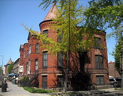
Reed-Cooke is a small urban neighborhood in Northwest Washington, D.C., situated within the boundaries of the larger and more prominent neighborhood of Adams Morgan, just north of the city's original L'Enfant-planned area. Its residents, and its local civic organization, the Reed-Cooke Neighborhood Association, generally consider it to be a distinct local neighborhood, although it is not on the city's list of formally recognized neighborhoods. For most official purposes, and to most Washingtonians, Reed-Cooke is a section of Adams Morgan.

Madams Organ Blues Bar

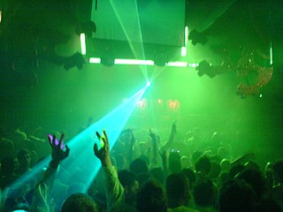
Madam's Organ Blues Bar is a restaurant and nightclub located at 2461 18th Street NW in Washington, D.C.'s Adams Morgan neighborhood. A local landmark, the bar is popular for its nightly live music, especially blues and bluegrass. Regular performers include Bobby Parker, Ben Andrews, Catfish Hodge, and Bob Perilla & Big Hillbilly Bluegrass. The bar offers billiards, has a rooftop deck and serves soul food. Notable regular patrons have included Euan Blair, son of Tony Blair, and the late Soviet dissident artist Alexandr Zhdanov. Hungarian Ambassador András Simonyi was not only a regular patron but also performed with his band "Coalition of the Willing" for his Washington Diplomatic farewell party attended by a Washington A-list including European diplomats, United States Secretary of Homeland Security Michael Chertoff, and Prime Minister Ferenc Gyurcsány. Additionally, Vince Vaughn and Owen Wilson were regulars during the filming of Wedding Crashers, and Politically Incorrect host Bill Maher always stops by when in Washington. Barbara and Jenna Bush have also been spotted there. Madam's Organ was described as a favored hangout by Playboy and Stuff (magazine), and was featured on the Wild On! travel series on E!.

Woodley Park (Washington, D.C.) neighborhood in Washington, D.C.

Woodley Park is a neighborhood in Northwest, Washington, DC. It is bounded on the north by Woodley Road and Klingle Road, on the east by the National Zoo and Rock Creek Park, on the south by Calvert Street, on the southwest by Cleveland Avenue, and on the west by 34th Street.

Benning Heights human settlement in United States of America

Benning Heights is a residential neighborhood located in northeast Washington, D.C. It is bounded by East Capitol Street to the south, Brooks Street NE to the north, 44th Street NE and Benning Road NE to the west, and Division Avenue NE to the east. It is served by the Benning Road Metro Rail station on the Blue Line and Silver Line of the Washington Metro.

Columbia Road

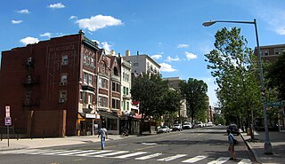
Columbia Road is a street in Washington, D.C., that forks from Connecticut Avenue north of Dupont Circle, and branches north and east through 16th Street to the McMillan Reservoir. Along its route, it marks the southern border of the Kalorama Triangle neighborhood, the principal east/west passage through the Adams Morgan neighborhood, and is one of the primary thoroughfares in the Columbia Heights neighborhood. In Adams Morgan, it is bordered by a great deal of street-level retail, constituting the main commercial area within Adams Morgan.

Washington Hilton

The Washington Hilton, which was officially known as the Hilton Washington for a period in the early 21st century and is sometimes referred to colloquially as the Hinckley Hilton by locals, is a hotel in Washington, D.C. It is located at 1919 Connecticut Avenue, N.W., roughly at the boundaries of the Kalorama, Dupont Circle, and Adams Morgan neighborhoods.

P Street Bridge bridge in United States of America

The P Street Bridge or Lauzun's Legion Bridge is a 336-foot (102 m) concrete arch bridge that conveys P Street across Rock Creek and Rock Creek Park between the Georgetown and Dupont Circle neighborhoods of Northwest Washington, D.C. The first bridge at this site was constructed in 1855 and was replaced in 1935 by the current structure.

L. Ron Hubbard House

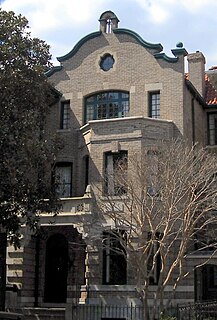
The L. Ron Hubbard House, also known as the Original Founding Church of Scientology, is a writer's house museum and former Scientology church located at 1812 19th Street NW in the Dupont Circle neighborhood of Washington, D.C., United States. Public tours are given on a regular basis. The operating Founding Church is now located at 1424 16th Street for services, bookstore and classes. The home served as the residence of Scientology founder L. Ron Hubbard from 1955 until 1959, during which time he incorporated the Founding Church of Scientology and performed the first Scientology wedding. The building is a contributing property to the Dupont Circle Historic District, a neighborhood listed on the National Register of Historic Places.

Golden Triangle, Washington DC is a neighborhood and business improvement district(BID) in Washington, D.C. Its location encompasses most of Washington’s central business district, and runs from the front yard of the White House north to Dupont Circle and from 16th Street to 21st Street NW and includes sections of K Street and Connecticut Avenue. The Golden Triangle BID was created in 1997 by the District of Columbia City Council and approved by Mayor Marion Barry. The commercial neighborhood that is home to more than 3,000 organizations such as top law firms, lobbyists, associations, and architecture firms; 200 restaurants; 300 shops and retailers; 7 hotels; and 6 national parks. Through a special assessment collected from property owners in a 43-block area, the Golden Triangle BID promotes and supports this area of downtown Washington DC through a number of services that include an Ambassador program focusing on cleanliness and hospitality, homeless outreach, streetscape improvements, marketing, outdoor summer concerts and other events, member services and more. Businesses that are located within the boundaries of the Golden Triangle BID are automatically members of the BID. The BID is governed by a Board of Directors composed of twenty-four property and business owners.

"Nupont," meaning "North of Dupont," is a moniker for the area north of Dupont Circle located in northwest Washington, D.C., United States. Nupont includes the neighborhoods of Dupont Circle, Adams Morgan, and Kalorama Heights. It is bound by Florida Avenue to the south, Connecticut Avenue and Columbia Avenue to the north and west, and 18th Street to the east.

References

  1. Marshall, Ryan (March 1, 2006). "Welcome to D.C.'s 18th Street". American Observer. Archived from the original on September 1, 2006. Retrieved January 1, 2007.

Coordinates: 38°54′43.4″N77°2′29.9″W / 38.912056°N 77.041639°W / 38.912056; -77.041639

Geographic coordinate system Coordinate system

A geographic coordinate system is a coordinate system that enables every location on Earth to be specified by a set of numbers, letters or symbols. The coordinates are often chosen such that one of the numbers represents a vertical position and two or three of the numbers represent a horizontal position; alternatively, a geographic position may be expressed in a combined three-dimensional Cartesian vector. A common choice of coordinates is latitude, longitude and elevation. To specify a location on a plane requires a map projection.