Ohio Drive (Washington, D.C.)

Last updated
Ohio Drive

Looking N along Ohio Drive East - East Potomac Park - 2013-08-25.jpg

Looking north along Ohio Drive SW on the eastern shore of East Potomac Park
Other name(s) Ohio Drive SW
Former name(s) Riverside Drive
Maintained by DDOT
Location Washington, D.C., U.S.
Coordinates 38°52′45.5″N77°1′49.3″W / 38.879306°N 77.030361°W / 38.879306; -77.030361 Coordinates: 38°52′45.5″N77°1′49.3″W / 38.879306°N 77.030361°W / 38.879306; -77.030361
West endI-66.svgUS 50.svg I66 / US 50 / Rock Creek Parkway
Major
junctions
Lincoln Memorial Circle
Independence Avenue
I-395.svg I395
East end Maine Avenue
Construction
Construction start 1912 [1]
Completion 1916 [2]
Inauguration 1913 [1]

Ohio Drive is a street in Southwest Washington, D.C., located in East and West Potomac Parks and bordering the Tidal Basin, Washington Channel, and the Potomac River. It is a central organizing feature of East Potomac Park, providing the only major vehicular route to and through the area. [3] Unlike most roadways named after states in the District of Columbia, Ohio Drive is not an avenue, nor it is heavily used like Wisconsin or Rhode Island Avenues. However, the segment from Independence Avenue to the Rock Creek and Potomac Parkway is an important commuter route. [4]

Street A public thoroughfare in a built environment

A street is a public thoroughfare in a built environment. It is a public parcel of land adjoining buildings in an urban context, on which people may freely assemble, interact, and move about. A street can be as simple as a level patch of dirt, but is more often paved with a hard, durable surface such as tarmac, concrete, cobblestone or brick. Portions may also be smoothed with asphalt, embedded with rails, or otherwise prepared to accommodate non-pedestrian traffic.

Washington, D.C. Capital of the United States

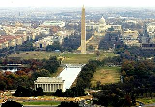
Washington, D.C., formally the District of Columbia and commonly referred to as Washington or D.C., is the capital of the United States. Founded after the American Revolution as the seat of government of the newly independent country, Washington was named after George Washington, the first President of the United States and a Founding Father. As the seat of the United States federal government and several international organizations, Washington is an important world political capital. The city is also one of the most visited cities in the world, with more than 20 million tourists annually.

East Potomac Park

East Potomac Park is a park located on a man-made island in the Potomac River in Washington, D.C., in the United States. The park lies southeast of the Jefferson Memorial and the 14th Street Bridge, and the park lies between the Washington Channel and the Potomac River. Amenities in East Potomac Park include the East Potomac Park Golf Course, a miniature golf course, a public swimming pool, tennis courts, and several athletic fields. The park is a popular spot for fishermen, and cyclists, walkers, inline skaters, and runners heavily use the park's roads and paths. A portion of Ohio Drive SW runs along the perimeter of the park.

Contents

Ohio Drive SW is a contributing property to the East and West Potomac Parks National Historic District, which was added to the National Register of Historic Places in November 1973. [1]

National Register of Historic Places federal list of historic sites in the United States

The National Register of Historic Places (NRHP) is the United States federal government's official list of districts, sites, buildings, structures, and objects deemed worthy of preservation for their historical significance. A property listed in the National Register, or located within a National Register Historic District, may qualify for tax incentives derived from the total value of expenses incurred preserving the property.

Route description

Ohio Drive starts at the Lincoln Memorial and continues south on the west side of West Potomac Park. It crosses a small channel connecting the Potomac River to the Tidal Basin via the Tidal Basin Inlet Bridge, [5] and continues under the 14th Street Bridge and the Washington Metro Yellow Line span. The street enters and continues along the west side of East Potomac Park almost to the southern point of the island, then turns northwest up the eastern side of the island. Ohio Drive passes under 14th Street and CSX railroad tracks before ending at East Basin Drive (where that street connects to Maine Avenue). [6]

Lincoln Memorial American national monument

The Lincoln Memorial is an American national memorial built to honor the 16th President of the United States, Abraham Lincoln. It is located on the western end of the National Mall in Washington, D.C., across from the Washington Monument. The architect was Henry Bacon; the designer of the primary statue – Abraham Lincoln, 1920 – was Daniel Chester French; the Lincoln statue was carved by the Piccirilli Brothers; and the painter of the interior murals was Jules Guerin. Dedicated in May 1922, it is one of several memorials built to honor an American president. It has always been a major tourist attraction and since the 1930s has been a symbolic center focused on race relations.

Washington Metro rapid transit system of the Washington, DC Metropolitian Area

The Washington Metro, or locally simply Metro, is the common name of Metrorail, the rapid transit system serving the Washington metropolitan area of the United States. It is administered by the Washington Metropolitan Area Transit Authority (WMATA), which also operates the Metrobus service under the Metro name. Opened in 1976, the network now includes six lines, 91 stations, and 117 miles (188 km) of route.

Yellow Line (Washington Metro) Washington Metro rapid transit line

The Yellow Line is a rapid transit line of the Washington Metro system, consisting of 17 stations in Fairfax County, Alexandria, and Arlington County, Virginia, as well as Washington, D.C.. The Yellow Line runs its full route from Huntington in Virginia to Fort Totten during off-peak hours, but short turns at Mount Vernon Square during peak hours. Additional Yellow Line trains continue north of Fort Totten, to Greenbelt in Prince George's County, Maryland, during off-peak hours and weekends in order to stage them for Green Line service or for storage at the Greenbelt rail yard. Metro is proposing to extend all Yellow line service to Greenbelt.

History

Construction

Construction on what was then known as Riverside Drive SW began in 1912 and was completed in 1916. [1] A portion of it was already finished by June 1913. (President Woodrow Wilson walked along it to take in the view.) [2] The road was nicknamed "The Speedway" from the informal horse and buggy racing that used to occur on the road. [7]

Woodrow Wilson 28th president of the United States

Thomas Woodrow Wilson was an American statesman, lawyer, and academic who served as the 28th president of the United States from 1913 to 1921. A member of the Democratic Party, Wilson served as the president of Princeton University and as the 34th governor of New Jersey before winning the 1912 presidential election. As president, he oversaw the passage of progressive legislative policies unparalleled until the New Deal in 1933. He also led the United States during World War I, establishing an activist foreign policy known as "Wilsonianism."

Horse and buggy two wheeled convertible carraige with one bench for two passengers, controlled from the seat. Primarily for casual rides and leisure

A horse and buggy or horse and carriage refers to a light, simple, two-person carriage of the late 18th, 19th and early 20th centuries, drawn usually by one or sometimes by two horses. Also called a roadster or a trap, it was made with two wheels in England and the United States, and with four wheels in the United States as well. It had a folding or falling top.

Riverside Drive in West Potomac Park was lit at night using the "Twin Twentys" lamppost. These wrought iron light standards, approved by the United States Commission of Fine Arts, have twin globes connected to a main pole by a decorative U-shaped bracket. The main pole is octagonal in cross-sextion and 15 feet (4.6 m) high. With the bracket and globes, the lamppost's total height is 21 feet (6.4 m). [8] As constructed, the road was one lane wide and consisted of macadam. At some point between 1916 and 1941, the portion of the road on the east side of the island between the railroad tracks and East Potomac Park Golf Course was turned into a two-lane road divided by a boulevard. [1]

Street lighting in the District of Columbia

Street lighting in the District of Columbia is provided by the District of Columbia Department of Transportation, and covers all city streets and alleys in Washington, D.C., in the United States. Because the Constitution of the United States makes the District of Columbia a creature of the United States federal government, the federal government has the authority to regulate the type and appearance of street lighting. The United States Congress has delegated a part of this authority to the United States Commission of Fine Arts, which controls the appearance of lighting standards in certain areas of the city.

United States Commission of Fine Arts independent agency of the federal government of the United States

The U.S. Commission of Fine Arts (CFA) is an independent agency of the federal government of the United States, and was established in 1910. The CFA has review authority over the "design and aesthetics" of all construction within Washington, D.C. In accordance with the Old Georgetown Act, the CFA appoints the Old Georgetown Board. The Old Georgetown Board has design review authority over all semipublic and private structures within the boundaries the Georgetown Historic District. The CFA was granted approval authority by the Shipstead-Luce Act over the design and height of public and private buildings which front or abut the grounds of the United States Capitol, the grounds of the White House, Pennsylvania Avenue NW extending from the Capitol to the White House, Lafayette Square, Rock Creek Park, the National Zoological Park, the Rock Creek and Potomac Parkway, Potomac Park, and the National Mall and its constituent parks.

Macadam type of road construction pioneered by Scottish engineer John Loudon McAdam

Macadam is a type of road construction, pioneered by Scottish engineer John Loudon McAdam around 1820, in which single-sized crushed stone layers of small angular stones are placed in shallow lifts and compacted thoroughly. A binding layer of stone dust may form; it may also, after rolling, be covered with a binder to keep dust and stones together. The method simplified what had been considered state of the art at that point.

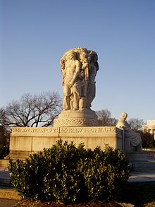
Important structures

A number of important and historic structures are located on Ohio Dive SW.

The John Ericsson National Memorial on Ohio Drive SW, whose dedication was attended by the Crown Prince of Sweden. Fraser Ericsson Memorial.jpg
The John Ericsson National Memorial on Ohio Drive SW, whose dedication was attended by the Crown Prince of Sweden.

The West Potomac Park Polo Grounds, located between Independence Avenue SW and Ohio Drive SW, were laid out in 1908. Paved over in 1942 to provide parking for the temporary United States Department of War offices on the National Mall, the southern half was restored to athletic fields in 1943. A Women Appointed to Voluntary Emergency Services (WAVES) dormitory was constructed on the remaining parking lot in 1944. The dormitory was demolished in 1965, and the area at last completely restored to athletic fields. [9]

United States Department of War Former US government agency

The United States Department of War, also called the War Department, was the United States Cabinet department originally responsible for the operation and maintenance of the United States Army, also bearing responsibility for naval affairs until the establishment of the Navy Department in 1798, and for most land-based air forces until the creation of the Department of the Air Force on September 18, 1947.

National Mall national park in Washington, D.C.

The National Mall is a landscaped park within the National Mall and Memorial Parks, an official unit of the United States National Park System. It is located near the downtown area of Washington, D.C., the capital city of the United States, and is administered by the National Park Service (NPS) of the United States Department of the Interior.

WAVES Womens branch of the United States Naval Reserve during World War II

The United States Naval Reserve , better known as the WAVES, was the women's branch of the United States Naval Reserve during World War II. It was established on July 21, 1942 by the U.S. Congress and signed into law by President Franklin D. Roosevelt on July 30. This authorized the U.S. Navy to accept women into the Naval Reserve as commissioned officers and at the enlisted level, effective for the duration of the war plus six months. The purpose of the law was to release officers and men for sea duty and replace them with women in shore establishments. Mildred H. McAfee, on leave as president of Wellesley College, became the first director of the WAVES. She was commissioned a lieutenant commander on August 3, 1942, and later promoted to commander and then to captain.

In 1926, the John Ericsson National Memorial was erected on Riverside Drive SW near the Lincoln Memorial. This statue commemorates the contributions of John Ericsson, a Swedish immigrant and designer of USS Monitor ironclad warship during the American Civil War. [10] President Calvin Coolidge and Prince Gustaf Adolf, Duke of Västerbotten, Crown Prince of Sweden, attended the dedication ceremonies. [11]

Riverside Drive was renamed Ohio Drive by 1950. [7] [12]

Cherry trees are also a defining feature of Ohio Drive. In the 1930s, a large grove of Yoshino cherry trees were planted on both sides of the street in the northwestern corner of West Potomac Park. [13] From 1966 to 1968, more than 1,800 Yoshino cherry and other trees were planted along Ohio Drive SW in East Potomac Park. The trees were donated and planted by friends of President Lyndon B. Johnson and First Lady Lady Bird Johnson in honor of Lady Bird Johnson's continuing efforts at civic beautification nationwide. A plaque commemorating the planting of these trees is located on the east shore of East Potomac Park on Ohio Drive. [14] The cherry trees, according to the National Park Service, "are a major character-defining component of the landscape of East Potomac Park" and are also considered a contributing property to the East and West Potomac Parks Historic District. [1]

In 1957, another major memorial was erected on Ohio Drive SW and West Basin Drive SW. This object is a 2-short-ton (1.8 t) stone Japanese Pagoda. The stone pagoda is a gift from the people of Yokohama, Japan, to the people of Washington, D.C. It arrived on June 19, 1957, in five separate pieces and was assembled on-site. Yokohama mayor Ryozo Kiranuma helped dedicate it once it was erected. [15] This stone pagoda is also a contributing property to the East and West Potomac Parks Historic District. [16]

Another historic object on Ohio Drive SW is the First Air Mail Flight Marker. This object consists of a brass plaque attached to a boulder next to the Polo Grounds south of Ohio Drive SW. It was dedicated on May 15, 1958, by the District of Columbia to mark the spot where the aircraft took off with the first scheduled domestic air mail service. The original marker was stolen in 1969 and the plaque was replaced in 1971. [17]

National Capital Parks structures

Two major National Capital Parks structures are located on Ohio Drive SW. The first is the headquarters of the National Capital Parks Central Office, which is at 900 Ohio Drive SW. [18]

The second is the U.S. Engineers' Storehouse, also located at 900 Ohio Drive SW. This structure was designed in 1912 by the noted local architectural firm of Wood, Donn and Deming. The Mediterranean Revival style building was constructed in 1913. This building is also a contributing property to the East and West Potomac Parks Historic District. [19]

Confusion with Ohio Avenue

Ohio Avenue in 1851 FederalTriangle 1851.jpg
Ohio Avenue in 1851

Ohio Drive should be distinguished from Ohio Avenue. Ohio Avenue was part of the original L'Enfant Plan for the District of Columbia. It began on 15th Street NW, halfway between C and D Streets NW, and ran southeast (parallel to Pennsylvania Avenue) until it reached a small plaza at 12th Street NW. The avenue was obliterated in the early 20th century by the Federal Triangle complex. [20] The Ronald Reagan Building and International Trade Center, Herbert C. Hoover Building, and Internal Revenue Service Building currently sit on the path of the old Ohio Avenue.

Related Research Articles

West Potomac Park urban park

West Potomac Park is a U.S. national park in Washington, D.C., adjacent to the National Mall. It includes the parkland that extends south of the Lincoln Memorial Reflecting Pool, from the Lincoln Memorial to the grounds of the Washington Monument. The park is the site of many national landmarks, including the Korean War Veterans Memorial, Jefferson Memorial, Franklin Delano Roosevelt Memorial, George Mason Memorial, and the Martin Luther King, Jr. National Memorial.

National Register of Historic Places listings in American Samoa Wikimedia list article

This is a list of the buildings, sites, districts, and objects listed on the National Register of Historic Places in American Samoa. There are currently 31 listed sites spread across the three districts of American Samoa. There are no sites listed on the unorganized atoll of Swains Island.

Boundary markers of the original District of Columbia

The boundary markers of the original District of Columbia are the 40 milestones that marked the four lines forming the boundaries between the states of Maryland and Virginia and the square of 100 square miles (259 km²) of federal territory that became the District of Columbia in 1801. Working under the supervision of three commissioners that President George Washington had appointed in 1790 in accordance with the federal Residence Act, a surveying team that Major Andrew Ellicott led placed these markers in 1791 and 1792. Among Ellicott's assistants were his brothers Joseph and Benjamin Ellicott, Isaac Roberdeau, George Fenwick, Isaac Briggs and an African American astronomer, Benjamin Banneker.

National Register of Historic Places listings in Crow Wing County, Minnesota Wikimedia list article

This is a list of the National Register of Historic Places listings in Crow Wing County, Minnesota. It is intended to be a complete list of the properties and districts on the National Register of Historic Places in Crow Wing County, Minnesota, United States. The locations of National Register properties and districts for which the latitude and longitude coordinates are included below, may be seen in an online map.

National Register of Historic Places listings in Morrison County, Minnesota Wikimedia list article

This is a list of the National Register of Historic Places listings in Morrison County, Minnesota. It is intended to be a complete list of the properties and districts on the National Register of Historic Places in Morrison County, Minnesota, United States. The locations of National Register properties and districts for which the latitude and longitude coordinates are included below, may be seen in an online map.

National Register of Historic Places listings in Otter Tail County, Minnesota Wikimedia list article

This is a list of the National Register of Historic Places listings in Otter Tail County, Minnesota. It is intended to be a complete list of the properties and districts on the National Register of Historic Places in Otter Tail County, Minnesota, United States. The locations of National Register properties and districts for which the latitude and longitude coordinates are included below, may be seen in an online map.

National Register of Historic Places listings in Pine County, Minnesota Wikimedia list article

This is a list of the National Register of Historic Places listings in Pine County, Minnesota. It is intended to be a complete list of the properties and districts on the National Register of Historic Places in Pine County, Minnesota, United States. The locations of National Register properties and districts for which the latitude and longitude coordinates are included below, may be seen in an online map.

National Register of Historic Places listings in Itasca County, Minnesota Wikimedia list article

This is a list of the National Register of Historic Places listings in Itasca County, Minnesota. It is intended to be a complete list of the properties and districts on the National Register of Historic Places in Itasca County, Minnesota, United States. The locations of National Register properties and districts for which the latitude and longitude coordinates are included below, may be seen in an online map.

National Register of Historic Places listings in Washington County, Minnesota Wikimedia list article

This is a list of the National Register of Historic Places listings in Washington County, Minnesota. It is intended to be a complete list of the properties and districts on the National Register of Historic Places in Washington County, Minnesota, United States. The locations of National Register properties and districts for which the latitude and longitude coordinates are included below, may be seen in an online map.

National Register of Historic Places listings in Cass County, Minnesota Wikimedia list article

This is a list of the National Register of Historic Places listings in Cass County, Minnesota. It is intended to be a complete list of the properties and districts on the National Register of Historic Places in Cass County, Minnesota, United States. The locations of National Register properties and districts for which the latitude and longitude coordinates are included below, may be seen in an online map.

National Register of Historic Places listings in Cook County, Minnesota Wikimedia list article

This is a list of the National Register of Historic Places listings in Cook County, Minnesota. It is intended to be a complete list of the properties and districts on the National Register of Historic Places in Cook County, Minnesota, United States. The locations of National Register properties and districts for which the latitude and longitude coordinates are included below, may be seen in an online map.

National Register of Historic Places listings in Douglas County, Minnesota Wikimedia list article

This is a list of the National Register of Historic Places listings in Douglas County, Minnesota. It is intended to be a complete list of the properties and districts on the National Register of Historic Places in Douglas County, Minnesota, United States. The locations of National Register properties and districts for which the latitude and longitude coordinates are included below, may be seen in an online map.

National Register of Historic Places listings in Houston County, Minnesota Wikimedia list article

This is a list of the National Register of Historic Places listings in Houston County, Minnesota. It is intended to be a complete list of the properties and districts on the National Register of Historic Places in Houston County, Minnesota, United States. The locations of National Register properties and districts for which the latitude and longitude coordinates are included below, may be seen in an online map.

National Register of Historic Places listings in Koochiching County, Minnesota Wikimedia list article

This is a list of the National Register of Historic Places listings in Koochiching County, Minnesota. It is intended to be a complete list of the properties and districts on the National Register of Historic Places in Koochiching County, Minnesota, United States. The locations of National Register properties and districts for which the latitude and longitude coordinates are included below, may be seen in an online map.

National Register of Historic Places listings in Logan County, Ohio Wikimedia list article

This is a list of the National Register of Historic Places listings in Logan County, Ohio.

National Register of Historic Places listings in Mower County, Minnesota Wikimedia list article

This is a list of the National Register of Historic Places listings in Mower County, Minnesota. It is intended to be a complete list of the properties and districts on the National Register of Historic Places in Mower County, Minnesota, United States. The locations of National Register properties and districts for which the latitude and longitude coordinates are included below, may be seen in an online map.

This is a list of the National Register of Historic Places listings in Voyageurs National Park.

References

  1. 1 2 3 4 5 6 "East and West Potomac Parks." Inventory-Nomination Form for Federal Properties. Form 10-306 (Oct. 1972). National Register of Historic Places. National Park Service. U.S. Department of the Interior. November 30, 1973, p. 66. Accessed 2013-09-23.
  2. 1 2 "President Walks Alone Along Riverside Drive." Washington Post. June 9, 1913.
  3. "East and West Potomac Parks." Inventory-Nomination Form for Federal Properties. Form 10-306 (Oct. 1972). National Register of Historic Places. National Park Service. U.S. Department of the Interior. November 30, 1973, p. 63. Accessed 2013-09-23.
  4. "East and West Potomac Parks." Inventory-Nomination Form for Federal Properties. Form 10-306 (Oct. 1972). National Register of Historic Places. National Park Service. U.S. Department of the Interior. November 30, 1973, p. 25. Accessed 2013-09-23.
  5. "East and West Potomac Parks." Inventory-Nomination Form for Federal Properties. Form 10-306 (Oct. 1972). National Register of Historic Places. National Park Service. U.S. Department of the Interior. November 30, 1973, p. 44. Accessed 2013-09-23.
  6. "East and West Potomac Parks." Inventory-Nomination Form for Federal Properties. Form 10-306 (Oct. 1972). National Register of Historic Places. National Park Service. U.S. Department of the Interior. November 30, 1973, p. 93. Accessed 2013-09-23.
  7. 1 2 "Sesqui Exhibit Opens Sunday; Speedway Renamed Ohio Drive." Washington Post. July 7, 1950.
  8. "East and West Potomac Parks." Inventory-Nomination Form for Federal Properties. Form 10-306 (Oct. 1972). National Register of Historic Places. National Park Service. U.S. Department of the Interior. November 30, 1973, p. 27. Accessed 2013-09-23.
  9. "East and West Potomac Parks." Inventory-Nomination Form for Federal Properties. Form 10-306 (Oct. 1972). National Register of Historic Places. National Park Service. U.S. Department of the Interior. November 30, 1973, p. 60. Accessed 2013-09-23.
  10. "East and West Potomac Parks." Inventory-Nomination Form for Federal Properties. Form 10-306 (Oct. 1972). National Register of Historic Places. National Park Service. U.S. Department of the Interior. November 30, 1973, p. 4. Accessed 2013-09-23.
  11. "Model of Ericsson Statue Coming Here." Washington Post. March 17, 1926; "President and Swedish Prince Honor Ericsson at Memorial Unveiling." Washington Post. May 30, 1926; "President Stresses Friendship With Sweden." Washington Post. May 30, 1926.
  12. "Ohio Drive Is Dedicated at Hains Point." Washington Post. July 10, 1950.
  13. "East and West Potomac Parks." Inventory-Nomination Form for Federal Properties. Form 10-306 (Oct. 1972). National Register of Historic Places. National Park Service. U.S. Department of the Interior. November 30, 1973, p. 34. Accessed 2013-09-23.
  14. "East and West Potomac Parks." Inventory-Nomination Form for Federal Properties. Form 10-306 (Oct. 1972). National Register of Historic Places. National Park Service. U.S. Department of the Interior. November 30, 1973, p. 64, 67. Accessed 2013-09-23.
  15. "City Given Two Tons of Jap Temple." Washington Post. May 24, 1957; Goode, James M. Washington Sculpture: A Cultural History of Outdoor Sculpture in the Nation's Capital. Baltimore, Md.: Johns Hopkins University Press, 2009, p. 497.
  16. "East and West Potomac Parks." Inventory-Nomination Form for Federal Properties. Form 10-306 (Oct. 1972). National Register of Historic Places. National Park Service. U.S. Department of the Interior. November 30, 1973, p. 48. Accessed 2013-09-23.
  17. "East and West Potomac Parks." Inventory-Nomination Form for Federal Properties. Form 10-306 (Oct. 1972). National Register of Historic Places. National Park Service. U.S. Department of the Interior. November 30, 1973, p. 60-61. Accessed 2013-09-23.
  18. "East and West Potomac Parks." Inventory-Nomination Form for Federal Properties. Form 10-306 (Oct. 1972). National Register of Historic Places. National Park Service. U.S. Department of the Interior. November 30, 1973, p. 21. Accessed 2013-09-23.
  19. "East and West Potomac Parks." Inventory-Nomination Form for Federal Properties. Form 10-306 (Oct. 1972). National Register of Historic Places. National Park Service. U.S. Department of the Interior. November 30, 1973, p. 67. Accessed 2013-09-23.
  20. "Plan 4 Federal Buildings." New York Times. July 8, 1926; "4 Sites Selected for U.S. Buildings in Local Program." Washington Post. July 8, 1926; "Department of Commerce Site." Washington Post. September 18, 1926.