Norfolk is an independent city in Virginia, United States. As of the 2020 census, Norfolk had a population of 238,005, making it the third-most populous city in Virginia after neighboring Virginia Beach and Chesapeake, and the 96th-most populous city in the nation. Norfolk holds a strategic position as the historical, urban, financial, and cultural center of the Hampton Roads region, which has more than 1.8 million inhabitants and is the 37th-largest metropolitan area in the U.S., with ten cities.

Elizabeth City is a city in Pasquotank county, United States. As of the 2020 census, it had a population of 18,629. Elizabeth City is the county seat and most populous city of Pasquotank County. It is the cultural, economic and educational hub of the sixteen-county Historic Albemarle region of northeastern North Carolina.

Anacostia is a historic neighborhood in Southeast Washington, D.C. Its downtown is located at the intersection of Marion Barry Avenue SE and the neighborhood contains commercial and government buildings, mid-rise mixed development, city-sanctioned art murals and galleries ,a perfroming arts center, a playhouse theater, the local landmark, "The Big Chair," Fredrick Douglass's Home and is adjacent to the Fort Stanton Park neighborhood which hosts the Smithsonian Anacostia Community Museum. It is located directly east of and along the Anacostia River, after which the neighborhood is named.

West Town, northwest of the Loop on Chicago's West Side, is one of the city's officially designated community areas. Much of this area was historically part of Polish Downtown, along Western Avenue, which was then the city's western boundary. West Town was a collection of several distinct neighborhoods and the most populous community area until it was surpassed by Near West Side in the 1960s. The boundaries of the community area are the Chicago River to the east, the Union Pacific railroad tracks to the south, the former railroad tracks on Bloomingdale Avenue to the North, and an irregular western border to the west that includes the grand city park called Humboldt Park. Humboldt Park is also the name of the community area to West Town's west, Logan Square is to the north, Near North Side to the east, and Near West Side to the south. The collection of neighborhoods in West Town along with the neighborhoods of Bucktown and the eastern portion of Logan Square have been referred to by some media as the "Near Northwest Side".
Berkley was an incorporated town in Norfolk County, Virginia. Chartered by an Act of Assembly in 1890, the Town of Berkley was located directly across the Eastern Branch Elizabeth River from the City of Norfolk in the South Hampton Roads area.
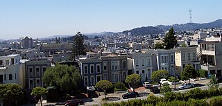
The Western Addition is a district in San Francisco, California, United States.
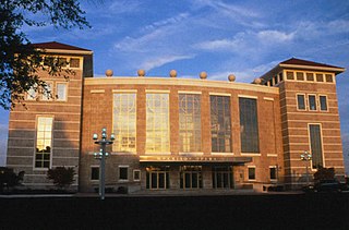
The Edythe C. and Stanley L. Harrison Opera House, also known as the Harrison Opera House, is the official home of the Virginia Opera in the Neon District of Downtown Norfolk on the border of the Ghent Square neighborhood.

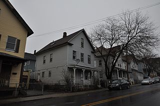
Park Place is a neighborhood in the western half of Norfolk, Virginia. Its boundaries are roughly Granby Street on the east, Colley Avenue on the west, 23rd Street on the south and up to 38th Street to the north. Within these boundaries Park Place is made up of 4 historic subdivisions; Virginia Place, East Kensington, Park Place, and East Old Dominion Place.

Fountain Square is one of seven designated cultural districts in Indianapolis, Indiana. Located just outside the city's downtown district, Fountain Square is home to three designated national historic districts, the Laurel and Prospect, the State and Prospect, and the Virginia Avenue districts, all of which were listed on the National Register of Historic Places in 1983. The neighborhood derives its name from the successive fountains that have been prominently featured at the intersection of Virginia Avenue, East Prospect Street, and Shelby Street.

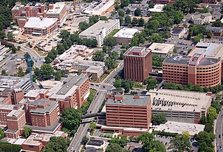
Downtown Norfolk serves as the traditional center of commerce, government, and culture in the Hampton Roads region. Norfolk, Virginia's downtown waterfront shipping and port activities historically played host to numerous and often noxious port and shipping-related uses. With the advent of containerized shipping in the mid-19th century, the shipping uses located on Norfolk's downtown waterfront became obsolete as larger and more modern port facilities opened elsewhere in the region. The vacant piers and cargo warehouses eventually became a blight on downtown and Norfolk's fortunes as a whole. But in the second half of the century, Norfolk had a vibrant retail community in its suburbs; companies like Smith & Welton, High's, Colonial Stores, Goldman's Shoes, Lerner Shops, Hofheimer's, Giant Open Air, Dollar Tree and K & K Toys were regional leaders in their respective fields. Norfolk was also the birthplace of Econo-Travel, now Econo Lodge, one of the nation's first discount motel chains.
Elizabeth takes its name from Elizabeth College, a small Lutheran women's college founded in 1897 on the present-day site of Presbyterian Hospital. The community began in 1891 when a streetcar was established along East Trade Street to the area, making it the second oldest streetcar suburb in Charlotte. Elizabeth began to develop rapidly after 1902, when a trolley line was completed, and was annexed in 1907. Home of Independence Park, the first public park in the city, Elizabeth became one of the most fashionable residential areas in Charlotte in its early days. In 2006 Elizabeth had a population of 3,908.

Sentara Norfolk General Hospital (SNGH) is a large academic hospital, which serves as the primary teaching institution for the adjacent Eastern Virginia Medical School. Located in Norfolk, Virginia, in the Ghent neighborhood and adjacent to Downtown, the hospital serves as the Hampton Roads region's only Level I trauma center. The hospital is interconnected to the Sentara Heart Hospital; however, it is considered a separate institution. Together with the adjacent Children's Hospital of the King's Daughters, Eastern Virginia Medical School and the Norfolk Department of Health, the Eastern Virginia Medical Center is the largest conglomerate center for health in Hampton Roads. For a time, the U.S. News & World Report rated it the best in Virginia. In 2016, SNGH is tied with VCU Medical Center ranked as #2 while University of Virginia Health System ranked first.

Gainsboro is a Roanoke, Virginia neighborhood located in central Roanoke immediately north of Downtown, across the Norfolk Southern Railway right of way, between Interstate 581 and Orange Avenue. It borders the neighborhoods of Harrison and Gilmer on the west, Washington Park on the north, Williamson Road on the east and Downtown Roanoke on the south. As of the 2000 U.S. Census, Gainsboro has a population of 967 residents.

The Virginia Park Historic District is located on the north side of New Center, an area in Detroit, Michigan, along both sides of Virginia Park Street from Woodward Avenue to the John C. Lodge Freeway access road. The district was listed on the National Register of Historic Places in 1982.

Sentara Health is a not-for-profit healthcare organization serving Virginia, northeastern North Carolina and Florida. It is based in Hampton Roads, Virginia, and offers services in 12 acute care hospitals, with 3,739 beds, 1.2 million members in its health plan, 10 nursing centers, and three assisted living facilities across the two states. Sentara Health operates its Sentara Health Plans division which covers 450,000 subscribers in the region. It also operates four medical groups.
The Sterling Hill Historic District in Bridgeport, Connecticut is a historic district that was listed on the National Register of Historic Places in 1992. The district is a two-block area of 43 urban residential structures dating as far back as 1821. Most of the buildings are from later in the 19th century when the neighborhood was largely occupied by Irish working-class residents. Most of the early buildings are vernacular wood-frame structures with modest Federal, Greek Revival, or Gothic Revival details, while the later additions include multiunit tenement-style buildings. The area includes the oldest urbanized part of the city.
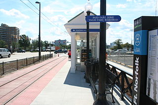
EVMC/Fort Norfolk is a Tide Light Rail station in Norfolk, Virginia. It opened in 2011 and is the western terminus of the line. It is situated at the intersection of Brambleton and Colley Avenues, just west of downtown and south of the historic Ghent district.
The following is a timeline of the history of the city of Norfolk, Virginia, United States.
The Oxford-Whitney Streets District is a historic district encompassing an early-20th century residential area in the West End neighborhood of Hartford, the capital city of the U.S. state of Connecticut. It extends along the east side of Oxford Street between Elizabeth and Cone Streets, and along the west side of Whitney between Fern and Elizabeth, and includes the north side of Fern Street between Whitney and Oxford. Most of the housing, a combination of single and multi-family residences, was built between 1906 and 1919, a period later than the surrounding areas, and is predominantly Colonial Revival in character. It was listed on the National Register of Historic Places in 2010.