Gibbon, Washington | |
---|---|
Coordinates: 46°14′09″N119°39′42″W / 46.2359668°N 119.6616967°W Coordinates: 46°14′09″N119°39′42″W / 46.2359668°N 119.6616967°W [1] | |
Country | United States |
State | Washington |
County | Benton |
Elevation | 643 ft (196 m) |
Time zone | UTC-8 (Pacific (PST)) |
• Summer (DST) | UTC-7 (PDT) |
ZIP code | 99350 |
Area code(s) | 509 |
GNIS feature ID | 1511509 [2] |
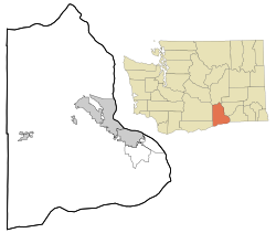
Gibbon is an unincorporated community in Benton County, Washington, United States, between Prosser and Benton City.
The community, primarily a railroad junction, was founded as Bender by the Northern Pacific Railway Company in 1884. In April 1896, Bender's name was changed to Gibbon in honor of U.S. Army General John Gibbon who died that same year. [3] [4]
Apricot is an unincorporated community in Benton County, Washington, United States, located between Prosser and Grandview.
Ashue is an unincorporated community in Yakima County, Washington, United States, located approximately two mile southwest of Wapato.
Farron is an unincorporated community in Yakima County, Washington, United States, located approximately five miles southwest of Wapato.
Holtzinger is an unincorporated community in Yakima County, Washington, United States, located approximately five miles northwest of Yakima.
Venner is an unincorporated community in Yakima County, Washington, United States, located approximately four miles southwest of Wapato.
Nass is an unincorporated community in Yakima County, Washington, United States, located approximately one mile east of Granger.
Lichty is an unincorporated community in Yakima County, Washington, United States, located between Sunnyside and Grandview on U.S. Route 12.
Byron is an unincorporated community in Yakima County, Washington, United States, located approximately three miles west of Prosser.
Birchfield is an unincorporated community in Yakima County, Washington, United States, located between Terrace Heights and Moxee.
Pomona is an unincorporated community in Yakima County, Washington, United States, located immediately northeast of Selah.
Weikel is an unincorporated community in Yakima County, Washington, United States, located approximately one mile north of Yakima, adjacent to Cowiche Creek, at the west end of Cowiche Canyon.
Badger is an unincorporated community in Benton County, Washington, United States, located approximately three miles southwest of Richland, near Badger Springs and Badger Canyon.
Berrian was an unincorporated community in Benton County, Washington, United States, located approximately nine miles east of Umatilla, Oregon on the north bank of the Columbia River.
Richland Junction is a neighborhood of Richland in Benton County, Washington, United States. It is located within the east city limits of Richland.
Longview is an unincorporated historic community in Benton County, Washington, United States, located approximately three miles west of Umatilla, Oregon on the north bank of the Columbia River, just above Devil's Bend Rapids.
North McNary is an unincorporated community in Benton County, Washington, United States, located immediately north of Umatilla, Oregon on the north bank of the Columbia River near McNary Dam.
North Prosser is an unincorporated community in Benton County, Washington, United States, located approximately one mile north of Prosser.
Vista is a neighborhood of Kennewick in Benton County, Washington, United States. It is located within the city limits of Kennewick.
Whitcomb is an unincorporated community in Benton County, Washington, United States, located approximately 22 miles south of Prosser on the north bank of the Columbia River on the south side of Canoe Canyon.
Yellepit was an unincorporated community in Benton County, Washington, United States, located approximately three miles southwest of Wallula on the west bank of the Columbia River.
This Benton County, Washington state location article is a stub. You can help Wikipedia by expanding it. |