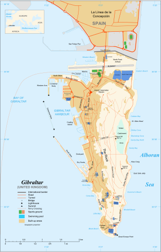
Map of the former Upper Rock Nature Reserve (north is to the left).
Originally named the Upper Rock Nature Reserve, it was limited to the upper part of the Rock of Gibraltar, a long and narrow limestone peninsula that rises to a height of 426 metres (1,398ft) above sea level.[1][2] The Rock is part of the Betic Cordillera, formed about 200 million years ago.[3] From the crest of the rock there is a dramatic view of the area, including Spain across the Bay of Gibraltar and Jebel Musa of Morocco across the Strait of Gibraltar. It is an area of considerable natural beauty and one of the main tourist attractions in Gibraltar.[1]
The reserve was established in 1993[2] to protect the area of land that the United Kingdom's Ministry of Defence had decommissioned from military use. Its purpose is to preserve the wildlife and natural and historical sites, while providing access to the public.[5] The flora and fauna of the nature reserve are protected by the law of Gibraltar.[6]
The nature reserve was last extended in 2013 when it was renamed the Gibraltar Nature Reserve to reflect its wider scope outside the Upper Rock. The protected area now covers the Great Gibraltar Sand Dune, Windmill Hill and the Europa Foreshore.[2]
Climate
Levant cloud forming against the eastern cliffs of the Rock of Gibraltar.
Gibraltar has a typical Mediterranean climate, moderated by the sea that almost surrounds the peninsula. Summers are warm and dry, while winters are cool and wet. Temperatures range from 13.4 to 24.2°C (56.1 to 75.6°F). Annual rainfall is about 768 millimetres (30.2in).[6] The Levanter clouds provide condensation that keeps the vegetation green even in the dry season.[5] These clouds form when moisture-laden easterly winds are forced upward by the cliffs of Gibraltar, and often form a cap over the Rock.[6]
Tourist attractions including St. Michael's Cave
The nature reserve contains many of Gibraltar's important natural history sites including caves such as St. Michael's Cave, with its many stalagmites and stalactites.[1] St. Michael's Cave was first mentioned by Pomponius Mela in 45AD, and many sources have mentioned it since. It has become an important tourist attraction. Concerts are held in its main chamber.[7]Forbes' Quarry is where the Neanderthal discovery was made in 1848. The Gibraltar 1 skull was one of the first to be found.[8] Neanderthal skulls have also been found at the Devil's Tower Cave on the North Front.[9] It is possible that some of the last Neanderthals may have made the caves of Gibraltar their home before they died out 30,000 years ago.[8]
At the southern end of Gibraltar Nature Reserve lies a series of caves: Levant Cave, George's Bottom Cave and Gibbon's Cave.[11] The first two caves are close together, accompanied by Tina's Fissure.[11] Levant Cave was discovered during military tunnelling and has similar formations to New St. Michael's Cave.[11] Gibbon's Cave was mostly destroyed due to tunnelling.[11] George's Bottom Cave was discovered in 1965, named after George Palao, and had a boulder blocking the cave entrance which was shifted away using machinery.[11] The passage of George's Bottom Cave is tight, requiring crawling at some points, including the entrance.[11] Crawling is made no easier by the cave coral which together with the curtains, columns, straws, and helictites create a variety of formations.[11] George's Bottom Cave has six descending levels and many chambers.[11]
Flora
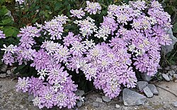
Gibraltar candytuft
In the past, the Upper Rock was tree-covered. Most of the trees were felled for fuel during the Great Siege of Gibraltar between 1779 and 1783. Trees today mostly produce berries that are eaten by birds, who presumably dropped their seeds on the rock. The most common is the olive (Olea europea). Carob (Ceratonia siliqua) and nettle trees (Celtis) are also found. Trees have been planted along the paths, including the stone pine (Pinus pinea) and Aleppo pine (Pinus halepensis). Both are native to the region, but the Aleppo pine is particularly common in dry, limestone regions. There was a drought in the 1990s when many of the introduced trees died, although the Aleppo pine fared better than others.[12]
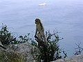
Mammals include the red fox, European rabbit and mouse-eared bat. The best-known residents are the Barbary macaques that make the reserve their home.[1] Gibraltar has a reintroduced population of Barbary macaques, the only wild primate species in Europe, the famous Rock apes.[15] The macaques may be found at the Ape's Den near the middle cable-car station, at the top cable car station, and near the Great Siege Tunnels.[16] As of 2012 there were from 200 to 250 macaques, all of them living in the nature reserve.[17] It is forbidden to feed the monkeys, but these rules have not always been followed. As a result, some of them have become aggressive and dependent on food from humans. In 2008 the government ordered a group of macaques to be culled that had taken to scavenging in the town centre.[18]
The Barbary partridge breeds on the Rock of Gibraltar and nowhere else on mainland Europe
The Rock of Gibraltar, at the head of the Strait, is a prominent headland, which accumulates migrating birds during the passage periods. The vegetation on the Rock, unique in southern Iberia, provides a temporary home for many species of migratory birds that stop to rest and feed before continuing migration for their crossing over the sea and desert. In spring, they return to replenish before continuing their journeys to Western Europe, journeys which may take them as far as Greenland or Russia.[citation needed]
Perez, Charles; Bensusan, Keith (2005). "A Guide to The Upper Rock Nature Reserve"(PDF). The Gibraltar Ornithological and Natural History Society. Archived from the original(PDF) on 10 May 2013. Retrieved 12 October 2012.
This page is based on this Wikipedia article Text is available under the CC BY-SA 4.0 license; additional terms may apply. Images, videos and audio are available under their respective licenses.