
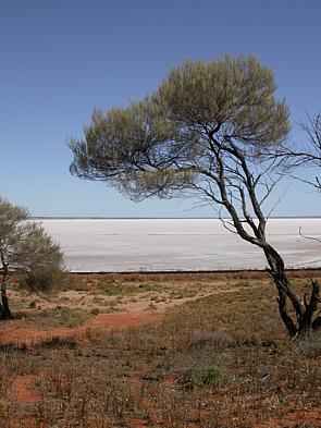
Lake Eyre, officially known as Kati Thanda–Lake Eyre, is an endorheic lake in the east-central part of the Far North region of South Australia, some 700 km (435 mi) north of Adelaide. The shallow lake is the depocentre of the vast endorheic Lake Eyre basin, and contains the lowest natural point in Australia, at approximately 15 m (49 ft) below sea level. On the rare occasions that it fills completely, it is the largest lake in Australia, covering an area of up to 9,500 km2 (3,668 sq mi). When the lake is full, it has the same salinity as seawater, but becomes hypersaline as the lake dries up and the water evaporates.

The Diamantina River is a major river in Central West Queensland and the far north of South Australia.
The Lake Eyre basin is a drainage basin that covers just under one-sixth of all Australia. It is the largest endorheic basin in Australia and amongst the largest in the world, covering about 1,200,000 square kilometres (463,323 sq mi), including much of inland Queensland, large portions of South Australia and the Northern Territory, and a part of western New South Wales. The basin is also one of the largest, least-developed arid zone basins with a high degree of variability anywhere. It supports only about 60,000 people and has no major irrigation, diversions or flood-plain developments. Low density grazing that sustains a large amount of wildlife is the major land use, occupying 82% of the total land within the basin. The Lake Eyre basin of precipitation to a great extent geographically overlaps the Great Artesian Basin underneath.

The Macquarie Marshes Nature Reserve is a protected natural wetland reserve that is located within the Macquarie Marshes, in the region along the lower Macquarie River in northwestern New South Wales, Australia. The 19,824-hectare (48,990-acre) reserve is situated approximately 600 kilometres (370 mi) northwest of Sydney and 100 kilometres (62 mi) north of Warren.

The Macquarie Marshes comprise the wetlands associated with the floodplains of the Macquarie River and its tributaries, in northern New South Wales, Australia. The Macquarie River and the marshes eventually drain into the Darling River. The marshes are important as a breeding site for waterbirds, especially in the aftermath of major floods.
Lake Galilee is a semi-arid salt lake in the locality of Galilee, Barcaldine Region, within the Desert Uplands area of Central West Queensland, Australia. The lake is about 36 kilometres long, up to 12.5 kilometres wide and covers approximately 25,700 hectares.

The Paroo-Darling National Park is a protected national park that is located in the Far West region of New South Wales, in eastern Australia. The 178,053-hectare (439,980-acre) national park spans two distinct regions in the outback area. This region covers the arid catchments of the Paroo River and the Paroo-Darling confluence to the south.

The Yanga National Park is a newly formed national park, located near the township of Balranald in south- western New South Wales. It covers an area of 66,734 hectares which includes 1,932 hectares of Yanga Nature Reserve, and has a frontage of 170 kilometres (110 mi) on the Murrumbidgee River. It is largely located in the Lower Murrumbidgee Floodplain, which is included on A Directory of Important Wetlands in Australia because of its importance as a breeding site for waterbirds when flooded.

The Ord River floodplain is the floodplain of the lower Ord River in the Shire of Wyndham-East Kimberley, in the Kimberley region of northern Western Australia. It lies within the Victoria Bonaparte IBRA bioregion and contains river, seasonal creek, tidal mudflat and floodplain wetlands, with extensive stands of mangroves, that support saltwater crocodiles and many waterbirds. It is recognised as an internationally important wetland area, with 1,384 square kilometres (534 sq mi) of it designated on 7 June 1990 as Ramsar Site 477 under the Ramsar Convention on Wetlands.

The Coongie Lakes is a freshwater wetland system located in the Far North region of South Australia. The 21,790-square-kilometre (8,410 sq mi) lakes system is located approximately 1,046 kilometres north of the Adelaide city centre. The wetlands includes lakes, channels, billabongs, shallow floodplains, deltas, and interdune swamps. It lies on the floodplain of Cooper Creek, an ephemeral river flowing through a desert landscape in the Lake Eyre Basin which rarely, after occasional large floods, empties into Lake Eyre. The wetland system has been recognised both as being of international importance by designation under the Ramsar Convention with a listing on 15 June 1987 and being nationally important within Australia with a listing in A Directory of Important Wetlands in Australia (DIWA). Its extent includes the regional town of Innamincka, the Malkumba-Coongie Lakes National Park, the Innamincka Regional Reserve, the Strzelecki Regional Reserve and the Coongie Lakes Important Bird Area.
The Lake Machattie Area is a 909 km2 tract of land comprising Lakes Machattie, Mipia and Koolivoo, with the surrounding Georgina River and Eyre Creek floodplains, in the arid Channel Country of western Queensland, Australia. The area is important as a breeding site for waterbirds.

The Lakes Muncoonie, Mumbleberry and Torquinie Important Bird Area is a 2013 km2 tract of land in the Channel Country of western Queensland, Australia.
The Lowbidgee Floodplain extends from Balranald to near Waradgery Station, about 20 km (12 mi) west of Hay, in south-western New South Wales. The Lowbidgee Floodplain is part of the Traditional lands of the Nari Nari and Muthi Muthi Aboriginal peoples.
The Narran Wetlands, also known as the Narran Lakes, contained within the Narran Lake Nature Reserve, comprise a series of protected ephemeral lakes and swamps fed by the Narran River in the north-west of New South Wales, Australia. The 26,480-hectare (65,400-acre) reserve is located approximately 50 kilometres (31 mi) east of Brewarrina.

The Natimuk-Douglas Wetlands comprise a chain of freshwater, brackish and saline wetlands in the semi-arid Wimmera region of western Victoria. Australia. They are important for waterbirds.
The North Victorian Wetlands, also known as the Kerang Wetlands, comprise an extensive series of over 100 freshwater, brackish and saline lakes and swamps on the floodplain of the Loddon River where it enters the Murray valley, in the vicinity of the town of Kerang, in northern Victoria, south-eastern Australia. They are important for a variety, and sometimes large numbers, of waterbirds.
The Paroo Floodplain and Currawinya Important Bird Area is a 7,874 km2 (3,040 sq mi) site comprising the floodplain and the associated wetlands of the Paroo River in north-western New South Wales and south-western Queensland, Australia. It includes extensive areas of the Paroo-Darling and Currawinya National Parks, both of which are listed under the Ramsar Convention as wetland sites of international importance, as well as of the Nocoleche Nature Reserve.
Lake Blanche is a salt lake in central South Australia that lies below sea level. It is located within the Strzelecki Creek Wetland System which is listed on A Directory of Important Wetlands in Australia. It also is within the extent of the Strzelecki Desert Lakes Important Bird Area, identified as such by BirdLife International because of its importance for waterbirds when holding water in the aftermath of floods.

The Strzelecki Desert Lakes Important Bird Area is an Important Bird Area (IBA) in the Australian state of South Australia which consists of a series of ephemeral waterbodies in the arid Strzelecki Desert in the state's Far North region. It is considered to be important for waterbirds when its constituent lakes hold water in the aftermath of floods.

The Gwydir Wetlands comprise a system of irregularly inundated wetlands associated with the Gwydir River in the North West Slopes region of north-eastern New South Wales, Australia. When flooded they form an important site for breeding waterbirds.

