Related Research Articles

The Diamantina River is a major river in Central West Queensland and the far north of South Australia.

The Cooper Creek is a river in the Australian states of Queensland and South Australia. It was the site of the death of the explorers Burke and Wills in 1861. It is sometimes known as the Barcoo River from one of its tributaries and is one of three major Queensland river systems that flow into the Lake Eyre basin. The flow of the creek depends on monsoonal rains falling months earlier and many hundreds of kilometres away in eastern Queensland. It is 1,300 kilometres (810 mi) in length.

The Thomson River is a perennial river that forms part of the Lake Eyre Basin, situated in the central west and western regions of Queensland, Australia. Much of the course of the river comprises a series of narrow channels synonymous with the Channel Country and the Galilee subregion.

The Barron River is located on the Atherton Tablelands inland from Cairns in North Queensland, Australia. With its headwaters below Mount Hypipamee, the 165-kilometre (103 mi)-long river with a catchment area of approximately 2,138 square kilometres (825 sq mi) forms through run off from the Mount Hypipamee National Park, flows through Lake Tinaroo, and eventually empties into the Coral Sea near Smithfield.

The Georgina River is the north-westernmost of the three major rivers of the Channel Country in Central West Queensland, that also flows through a portion of the Northern Territory, in central Australia. Part of the Lake Eyre basin, the Georgina flows in extremely wet years into Lake Eyre.

The Mackenzie River is a river in Central Queensland, Australia. The Mackenzie River is a major tributary of the Fitzroy River, part of the largest river catchment flowing to the eastern coast of Australia.

The Normanby River, comprising the East Normanby River, the West Normanby River, the East Normanby River North Branch, the East Normanby River South Branch and the Granite Normanby River, is a river system in Far North Queensland, Australia.
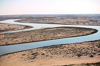
The Warburton River is a freshwater stream in the far north of South Australia that flows southwest and discharges into the eastern side of Lake Eyre. It is one of the state's largest rivers, and is part of the Lake Eyre Basin. It runs along the eastern side of the Simpson Desert, and drains water from Eyre Creek, the Diamantina and Georgina rivers from Goyder Lagoon, carrying it into Lake Eyre during its infrequent floods.
The Officer Creek, part of the Lake Eyre basin, is an ephemeral watercourse located in the Far North region in the Australian state of South Australia.
The Kallakoopah Creek, part of the Lake Eyre basin, is a watercourse located in the southern part of the Simpson Desert in the Australian state of South Australia. It is an anabranch of Warburton Creek.
The Pike Creek, a perennial stream that is one of the Border Rivers and part of the Macintyre catchment within the Murray–Darling basin, is located in the Darling Downs region of Queensland, Australia

The Annan River is a river in the Wet Tropics of Far North Queensland, Australia.

The Comet River is a river in Central Queensland, Australia.
The Leichhardt River is a river in north west Queensland, Australia.
Macumba River, once known as Treuer River, is an ephemeral freshwater stream in the far north of South Australia, that is part of the Lake Eyre Basin.
Yapunyah Waterhole lies in the Mulga Lands bioregion of western Queensland. The waterhole is about two kilometres long and covers approximately 22 hectares when full. It is defined as a permanent waterhole in a region where permanent waterholes are extremely rare and therefore provide important refuges for aquatic plants and animals. These rare waterholes were also vital for Aboriginal people and provided both spiritual and physical nourishment.
The Mission River is a river in Far North Queensland, Australia.
The Strzelecki Creek, part of the Lake Eyre basin, is an ephemeral watercourse located in the Australian state of South Australia.
The Wilson River, part of the Lake Eyre Basin, is an ephemeral river in the Channel Country in western Queensland, Australia.
The Julaolinja were an indigenous Australian people of the state of Queensland.
References
- ↑ "Map of Mulligan River, QLD (205 m – 62 m)". Bonzle.com.
- ↑ "Map of Mulligan River, QLD (62 m – 49 m)". Bonzle.com.
- ↑ "Georgina - Eyre Creek Basin map". Rainfall and River Conditions. Bureau of Meteorology . Retrieved 27 December 2018.
Rivers of Queensland | |||||||||||||||
|---|---|---|---|---|---|---|---|---|---|---|---|---|---|---|---|
| |||||||||||||||
| |||||||||||||||
| |||||||||||||||
| |||||||||||||||
| |||||||||||||||
| | This Queensland location article is a stub. You can help Wikipedia by expanding it. |