Bhind is a city in the Indian state of Madhya Pradesh. It is the headquarters of the Bhind district.

Jaunpur is a city and a municipal board in Jaunpur district in the Indian state of Uttar Pradesh. It is located 228 km southeast of state capital Lucknow. Demographically, Jaunpur resembles the rest of the Purvanchal area in which it is located.
Ballia is a city with a municipal board in the Indian state of Uttar Pradesh. The eastern boundary of the city lies at the junction of two major rivers, the Ganges and the Ghaghara. The city is situated 140 km (87 mi) east of Varanasi and about 380 km from the state capital Lucknow. It is home to a protected area, the Jai Prakash Narayan bird sanctuary. Ballia is around 4 km (2.5 mi) from Bihar.

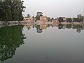
Bhadohi district is a district of Uttar Pradesh state in northern India. It is also referred to as Sant Ravidas Nagar. It is the smallest district by area in the state of Uttar Pradesh which was created on June 30, 1994 by dividing western part of the district Varanasi. It is surrounded by Varanasi district on east, Allahabad on west, Jaunpur north and Mirzapur district in south. The state capital Lucknow is distanced at 234 KM from Bhadohi. Its district headquarters is situated in the city of Gyanpur. The district is popularly known for carpet weaving as it is one of largest centres of Carpet Industries in India and therefore it also known as the 'Carpet City of India'. Carpets of Bhadohi have 'Geographical Indication' tag attached to it. Bhadohi has huge geographical significance and position attached to it due to its location between two culturally important and rich heritage cities of Prayagraj and Varanasi.
Azizpur is a census town in Agra district in the state of Uttar Pradesh, India.
Bhadohi is a city and municipal corporation in the Bhadohi district of northern Indian state of Uttar Pradesh. As the district headquarters of Bhadohi, it is home to the largest hand-knotted carpet-weaving industry hub in South Asia. The city has a long-standing tradition of weaving carpets which are known for their durability, unique patterns and the craftsmanship of the weavers. Bhadohi has geographical significance due to its location between two culturally important and rich heritage cities of Prayagraj and Varanasi.
Dhanuha is a census town in Jaunpur district in the state of Uttar Pradesh, India.
Dostpur is a town and a nagar panchayat in Sultanpur district in the state of Uttar Pradesh, India. The town borders Sultanpur and Ambedkarnagar. Purvanchal Expressway passes near the town.
Etmadpur is a town (tehsil) in Agra district in the state of Uttar Pradesh, India. It is located eastward 19 km from Agra. It is 274 km far from state capital Lucknow.

Fatehpur Chaurasi is a town and a nagar panchayat in Unnao district in the state of Uttar Pradesh, India. First officially classified as a town for the 1981 census, Fatehpur Chaurasi is located on the north bank of the Kalyani river, a bit to the south of the main road from Unnao to Bangarmau. Local industries include the production of furniture, boxes, almirahs, shoes, and slippers. As of 2011, the town's population is 6,715, in 1,158 households.
Gulaothi is a town, near Bulandshahr city in the Bulandshahr district that falls under the Meerut division of the Indian state of Uttar Pradesh.
Kairana is a city and a municipal board in Shamli district of the Indian state of Uttar Pradesh. It is approximately 14 km (8.7 mi) from Shamli city.
Lal Gopalganj Nindaura is a town and a nagar panchayat in Prayagraj district in Indian state of Uttar Pradesh.

Machhlishahr is a town in Jaunpur district in the Indian state of Uttar Pradesh. It is situated 30 km west of district headquarters Jaunpur. NH-231 passes through the city. Machhlishahr – Janghai NH-731B – Bhadohi four-lane national highway is under construction which will boost the economy of the region. Machhlishahr is a Nagar panchayat and there has been a longstanding demand for making it a Nagar palika parishad. In 2020, Machhalisahar nagar panchayat has secured 33rd all India rank in Swachh Survekshan cleanliness survey.
Mariahu (Mariyahu) is a town and a nagar panchayat in Jaunpur district in the Indian state of Uttar Pradesh. Its name Mariahu was given by Nanwag (Nandwak) king Naun Rao in 16th century on the name of Mandav Deo, the patreon deity of the Nanwag clan. The samadhi of Mandav dev is situated near to Chutka Devi temple which is in the east of tehsil. Mostly tehsil was ruled by Nanwag Rajputs who were the local rulers during 16th and 17th century. Baghi Sangram Singh a leader of the Nanwags revolted against the British East India company during the revolt of 1857 and defeated them on several occasions. It is one of the six tehsils of Jaunpur district, with the others being Jaunpur city, Shahganj, Machalishahar, Badlapur and Keraket.
Nainana Jat is a census town in Agra district in the Indian state of Uttar Pradesh.
Pinahat is a town and a nagar panchayat in Agra district in the Indian state of Uttar Pradesh and situated on the Bank of Chambal River. It is about 55 km from Agra. The distance between Pinahat and Chambal is only 2 km.
Sarai Mir is a town and a nagar panchayat in Azamgarh district in the Indian state of Uttar Pradesh.
Manpur is a town and a nagar panchayat in Mhow Tehsil of Indore district in the Indian state of Madhya Pradesh.

Dewa Sharif or Dewa is a town and a nagar panchayat in Barabanki district in the state of Uttar Pradesh, India. It is famous for the shrine of Haji Waris Ali Shah. This town is also known by the name of Dewa Sharif in respect for the shrine. It is about 26 km north-east of the state capital Lucknow.