Harlingen, New Jersey | |
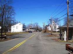
---|---|
Location in Somerset County Location in New Jersey | |
Coordinates: 40°26′58″N74°39′31″W / 40.449363°N 74.658505°W [1] [2] | |
Country | United States |
State | New Jersey |
County | Somerset |
Township | Montgomery |
Area | |
• Total | 0.81 sq mi (2.09 km2) |
• Land | 0.81 sq mi (2.09 km2) |
• Water | 0.00 sq mi (0.00 km2) 0.00% |
Elevation | 79 ft (24 m) |
Population | |
• Total | 430 |
• Density | 533.50/sq mi (205.88/km2) |
Time zone | UTC−05:00 (Eastern (EST)) |
• Summer (DST) | UTC−04:00 (Eastern (EDT)) |
Area code(s) | 609/640 and 732/848 |
FIPS code | 34-29940 [1] [6] [7] |
GNIS feature ID | 02584000 [1] [8] |
Harlingen is an unincorporated community and census-designated place (CDP) [9] located within Montgomery Township, in Somerset County, in the U.S. state of New Jersey. [10] [11] [12] [13] As of the 2010 United States Census, the CDP's population was 297. [14]
It is adjacent to the historical areas of Dutchtown and Bridgepoint. Harlingen Road and U.S. Route 206 intersect in the center of Harlingen. The Harlingen Dutch Reformed Church on Route 206 is extant and had an associated cemetery. The town was a stop on the short-lived Mercer and Somerset Railway.
According to the United States Census Bureau, Harlingen had a total area of 0.717 square mile (1.858 km2), all of which was land. [1] [2]
Census | Pop. | Note | %± |
---|---|---|---|
2010 | 297 | — | |
2020 | 430 | 44.8% | |
Population sources: 2010 [14] 2020 [5] |
The 2010 United States census counted 297 people, 93 households, and 81 families in the CDP. The population density was 414.1 per square mile (159.9/km2). There were 98 housing units at an average density of 136.6 per square mile (52.7/km2). The racial makeup was 77.78% (231) White, 1.68% (5) Black or African American, 0.00% (0) Native American, 16.50% (49) Asian, 0.00% (0) Pacific Islander, 2.36% (7) from other races, and 1.68% (5) from two or more races. Hispanic or Latino of any race were 5.72% (17) of the population. [14]
Of the 93 households, 54.8% had children under the age of 18; 79.6% were married couples living together; 4.3% had a female householder with no husband present and 12.9% were non-families. Of all households, 10.8% were made up of individuals and 3.2% had someone living alone who was 65 years of age or older. The average household size was 3.19 and the average family size was 3.46. [14]
30.6% of the population were under the age of 18, 7.4% from 18 to 24, 16.2% from 25 to 44, 38.7% from 45 to 64, and 7.1% who were 65 years of age or older. The median age was 42.3 years. For every 100 females, the population had 113.7 males. For every 100 females ages 18 and older there were 100.0 males. [14]
The Harlingen Dutch Reformed Church is in the Belle Mead, New Jersey section of Montgomery Township. The congregation was organized in 1727, and the minister was one of the major antagonists in the dispute between the traditionalists and the American party that contested governance of the Dutch Reformed Church. The church is still active.
The Reverend Johannes Arondeus, sent by the Classis of Amsterdam, was pastor from 1747 to 1754.
Kingston is an unincorporated community and census designated place (CDP) along the border of South Brunswick Township in Middlesex County and Franklin Township in Somerset County, and also located relatively near Princeton in Mercer County in the U.S. state of New Jersey. The historic settlement is in the Raritan Valley region, located along the course of the Millstone River. As of the 2010 United States Census, the CDP's population was 1,493, of which 1,222 were in South Brunswick Township and 271 in Franklin Township.
Plainsboro Center is an unincorporated community and census-designated place (CDP) located within Plainsboro Township, in Middlesex County, in the U.S. state of New Jersey. As of the 2010 United States Census, the CDP's population was 2,712.
Belle Mead is an unincorporated community and census-designated place (CDP) located within Montgomery Township, in Somerset County, in the U.S. state of New Jersey. As of the 2020 United States census, the CDP's population was 5,569, reflecting an expansion of the CDP from 0.74 square miles (1.9 km2) in 2010 to 4.03 square miles (10.4 km2) in 2020.
Blackwells Mills is an unincorporated community and census-designated place (CDP) located in Franklin Township in Somerset County, in the U.S. state of New Jersey. As of the 2010 U.S. census, the CDP's population was 803.
Six Mile Run is an unincorporated community and census-designated place (CDP) located in Franklin Township, in Somerset County, in the U.S. state of New Jersey. As of the 2010 United States Census, the CDP's population was 3,184.
Griggstown is an unincorporated community and census-designated place (CDP) located within Franklin Township, in Somerset County, in the U.S. state of New Jersey. As of the 2010 United States Census, the CDP's population was 819. The area was first settled around 1733.
Middlebush is an unincorporated community and census-designated place (CDP) located in Franklin Township, in Somerset County, in the U.S. state of New Jersey. As of the 2010 United States Census, the CDP's population was 2,326. It is perhaps most distinguished as being the host section for Franklin Township's municipal complex.
Blawenburg is an unincorporated community and census-designated place (CDP) located within Montgomery Township, in Somerset County, in the U.S. state of New Jersey. As of the 2010 United States Census, the CDP's population was 280. It is located at the juncture of two large roads, CR 518 and CR 601.
East Millstone is an unincorporated community and census-designated place (CDP) located in Franklin Township in Somerset County, in the U.S. state of New Jersey.
Franklin Park is an unincorporated community and census-designated place (CDP) located within Franklin Township, in Somerset County, in the U.S. state of New Jersey. As of the 2010 United States Census, the CDP's population was 13,295. Route 27 bisects the village and serves as the dividing line between the two counties. The adjacent sections of South Brunswick and North Brunswick, Middlesex County on the east side of Route 27 are also known as Franklin Park, but are not included within the CDP's boundaries.
Clyde is an unincorporated community and census-designated place (CDP) located in Franklin Township, in Somerset County, in the U.S. state of New Jersey. It was a station stop on the Penna RR's Millstone Branch. As of the 2010 United States Census, the CDP's population was 213.
East Franklin is an unincorporated community and census-designated place (CDP) located in Franklin Township, in Somerset County, in the U.S. state of New Jersey. At the 2010 United States Census, East Franklin's population was 8,669.
East Rocky Hill is an unincorporated community and census-designated place (CDP) located in Franklin Township, in Somerset County, in the U.S. state of New Jersey. As of the 2010 United States Census, the CDP's population was 469.
Franklin Center is an unincorporated community and census-designated place (CDP) located in Franklin Township, in Somerset County, in the U.S. state of New Jersey. As of the 2010 United States Census, the CDP's population was 4,460.
Finderne is an unincorporated community and census-designated place (CDP) located within Bridgewater Township, in Somerset County, in the U.S. state of New Jersey. As of the 2010 United States Census, the CDP's population was 5,600.
Bradley Gardens is an unincorporated community and census-designated place (CDP) located within Bridgewater Township, in Somerset County, in the U.S. state of New Jersey. As of the 2010 United States Census, the CDP's population was 14,206.
Green Knoll is an unincorporated community and census-designated place (CDP) located within Bridgewater Township, in Somerset County, in the U.S. state of New Jersey. As of the 2010 United States Census, the CDP's population was 6,200.
Ten Mile Run is an unincorporated community and census-designated place (CDP) located in Franklin Township, in Somerset County, in the U.S. state of New Jersey. As of the 2010 United States Census, the CDP's population was 1,959.
Voorhees is an unincorporated community and census-designated place (CDP) located in Franklin Township, in Somerset County, in the U.S. state of New Jersey. As of the 2010 United States Census, the CDP's population was 1,959.
Harmony is an unincorporated community and census-designated place (CDP) located within Harmony Township in Warren County, in the U.S. state of New Jersey, that was defined as part of the 2010 United States Census. As of the 2010 Census, the CDP's population was 441.