Hobart city centre

Last updated
Hobart
Hobart,  Tasmania
Articulated-intersect-in-hbt2.jpg
The Hobart CBD
Population456 (2006) [1]
 • Density240/km2 (622/sq mi)
Established1803
Postcode(s) 7000, 7001
Area1.9 km2 (0.7 sq mi)
LGA(s) City of Hobart
State electorate(s) Clark
Federal Division(s) Denison
Suburbs around Hobart:
West Hobart North Hobart Glebe
West Hobart Hobart Glebe
South Hobart Sullivan's Cove Sullivan's Cove

Hobart City Centre (referred to as Town or Hobart CBD) is a suburb surrounded by metropolitan Hobart, which comprises the original settlement, the central business district, and other built-up areas. It is the oldest part of Hobart and includes many of the city's important institutions and landmarks, such as Parliament, the Supreme Court, Franklin Square, the Elizabeth Street Mall, the Royal Hobart Hospital, the Theatre Royal, State Library, the NAB Building, the Museum, and the Cenotaph. The city centre is located in the local government areas of the City of Hobart.

Hobart City in Tasmania, Australia

Hobart is the capital and most populous city of the Australian island state of Tasmania. With a population of approximately 225,000, it is the least populated Australian state capital city, and second smallest if territories are taken into account. Founded in 1804 as a British penal colony, Hobart, formerly known as Hobart Town or Hobarton, is Australia's second oldest capital city after Sydney, New South Wales. Prior to British settlement, the Hobart area had been occupied for possibly as long as 35,000 years, by the semi-nomadic Mouheneener tribe, a sub-group of the Nuennone, or South-East tribe. The descendants of these Aboriginal Tasmanians often refer to themselves as 'Palawa'.

Parliament House, Hobart house of parliament for State of Tasmania, Australia

Parliament House, Hobart, located on Salamanca Place in Hobart, Tasmania, Australia, is the meeting place of the Parliament of Tasmania. The building was originally designed as a customs house but changed use in 1841 when Tasmania achieved self-government. The building served both purposes from 1841 to 1904, when the customs offices were relocated.

Supreme Court of Tasmania

The Supreme Court of Tasmania is the highest State court in the Australian State of Tasmania. In the Australian court hierarchy, the Supreme Court of Tasmania is in the middle level, with both an appellate jurisdiction over lower courts, and decisions made by Court to be heard on appeal by the High Court of Australia.

Contents

Although the city centre is one of the oldest and most developed areas of Hobart, demographically it is one of the less densely populated areas in the greater area of Hobart, due to its core being commercial. In an attempt to create a more vibrant city at night, the state government has been encouraging inner city residential development in recent years. [2] [3] The population of the city centre was 456 in 2006. [1]

History

Settlement of Greater Hobart spawned from the settlement of Sullivans Cove on 21 February 1804, by order of David Collins who was most unimpressed with the initial landing site at Risdon Cove.

Sullivans Cove

Sullivans Cove is on the River Derwent adjacent to the Hobart CBD in Tasmania.

Risdon Cove cove near Hobart, Tasmania, Australia

Risdon Cove is located on the east bank of the Derwent River, approximately 7 kilometres (4 mi) north of Hobart, Tasmania. It was the site of the first British settlement in Van Diemen's Land, now Tasmania, the smallest Australian state. The cove was named by John Hayes, who mapped the river in the ship Duke of Clarence in 1794, after his second officer William Bellamy Risdon.

Geography

The Hobart city centre draws a sense of its identity from its location between the Derwent River and the foot hills of Mount Wellington. The city is concentrated with Low-rise office buildings, interspersed by parks such as Franklin Square and St Davids Park and historic precincts such as Sullivans Cove and Salamanca Place. Due to street width, the majority of Hobart CBD's streets are One-way with a few exceptions including Elizabeth Street, the main north-south thoroughfare of the city centre. Davey Street/Macquarie travel parallel as a one-way couplet carrying traffic between Hobart's major highways along the CBD's southern fringe. The streets run on a slightly warped grid pattern in the CBD, due to early planning by Lachlan Macquarie.

River Derwent (Tasmania) river in south east Tasmania, Australia

The Derwent River is a river located in Tasmania, Australia. It is also known by the palawa kani name timtumili minanya. The river rises in the state's Central Highlands at Lake St Clair, and descends more than 700 metres (2,300 ft) over a distance of more than 200 kilometres (120 mi), flowing through Hobart, the state's capital city, before emptying into Storm Bay and flowing into the Tasman Sea. The banks of the Derwent were once covered by forests and occupied by Tasmanian Aborigines. European settlers farmed the area and during the 20th century many dams were built on its tributaries for the generation of hydro-electricity.

Mount Wellington (Tasmania) mountain at Hobart, Tasmania

Mount Wellington, officially kunanyi / Mount Wellington, incorporating its Palawa kani name, is a mountain in the southeast coastal region of Tasmania, Australia. It is the summit of the Wellington Range and is within the Wellington Park reserve. Located at the foothills of the mountain is much of Tasmania's capital city, Hobart.

Salamanca Place Tasmania, Australia

Salamanca Place is a precinct of Hobart, the capital city of the Australian state of Tasmania.

Governance

Administratively, the Hobart City Centre falls under the authority of the local government area of the City of Hobart. [4] The Tasmanian Government also has authority over some aspects of the CBD, in particular the major state controlled roads passing through and around the city.

Local government in Australia is the third tier of government in Australia administered by the states and territories, which in turn are beneath the federal tier. Local government is not mentioned in the Constitution of Australia and two referenda in the 1970s and 1980s to alter the Constitution relating to local government were unsuccessful. Every state government recognises local government in their respective constitutions. Unlike Canada or the United States, there is only one level of local government in each state, with no distinction such as cities and counties.

City of Hobart Local government area in Tasmania, Australia

Hobart City Council is a local government body in Tasmania, covering the central metropolitan area of the state capital, Hobart. The Hobart local government area has a population of 50,439 and includes the suburbs of New Town, Sandy Bay and most of Fern Tree and Mount Nelson.

Commercial area

With the exception of Wrest Point Casino in Sandy Bay, the Hobart CBD contains all of Tasmania’s tallest buildings, including 39 Murray Street, 188 Collins Street and the Trafalgar Building. The tallest building in the city centre is NAB House at 58 m (190 ft), however planning restrictions limit future developments to a height of 42 m (138 ft). There have been some exceptions to this rule such as Wellington Centre standing at 48 m (157 ft) [5] and the new Royal Hobart Hospital K1/K2 Twin Towers [6] [7] which when complete, will stand at 48 m (157 ft) high. The City centre has several shopping areas including the Wellington Centre, Centrepoint and the historically significant Cat & Fiddle Arcade. During 2007, a spectacular inner city fire [8] was responsible for the loss of one of Hobart's Myer buildings and as a result will soon see construction of the 40 m (130 ft) Icon Complex, boasting a 5 level Myer with specialty shops as well as a Hotel with roof top bar. [9]

Wrest Point Hotel Casino hotel and casino complex in Hobart, Tasmania

The Wrest Point Hotel Casino was Australia's first legal casino, opening in the suburb of Sandy Bay in Hobart, Tasmania, on 10 February 1973.

Sandy Bay, Tasmania Suburb of Hobart, Tasmania, Australia

Sandy Bay is a suburb of the city of Hobart, Tasmania, Australia, located immediately south of the central business district, and adjoins the suburb of Battery Point. Sandy Bay is bounded on the east by the Derwent River, and has several beaches along the shore, the main beaches with public access are Nutgrove Beach and Long Beach.

Tasmania island state of Australia

Tasmania is an island state of Australia. It is located 240 km (150 mi) to the south of the Australian mainland, separated by Bass Strait. The state encompasses the main island of Tasmania, the 26th-largest island in the world, and the surrounding 334 islands. The state has a population of around 526,700 as of March 2018. Just over forty percent of the population resides in the Greater Hobart precinct, which forms the metropolitan area of the state capital and largest city, Hobart.

Culture

There is a large concentration of cultural institutions within the CBD including: the Tasmanian Museum and Art Gallery, the State Library of Tasmania, the Playhouse Theatre, and the Theatre Royal.

Every December, the city hosts the conclusion of the Sydney to Hobart Yacht Race while concurrently holding the Taste Festival. Every January the city hosts the Australian Wooden Boat Festival and the annual Royal Hobart Regatta is held during February.

Additional, the Salamanca Market is held at Salamanca Place every Saturday.

See also

Related Research Articles

The history of Tasmania begins at the end of the most recent ice age when it is believed that the island was joined to the Australian mainland. Little is known of the human history of the island until the British colonisation in the 19th century.

Brooker Highway highway in Tasmania

The Brooker Highway is a highway in the State of Tasmania, Australia. As one of Hobart's 3 major radials, the highway connects traffic from the Hobart city centre with the northern suburbs and is the major road connection to the cities and towns of Northern Tasmania. With an AADT of 48,000, the highway is one of the busiest in Tasmania. The Brooker Highway has recently been declared part of the National Highway.

Davey Street, Hobart street in Hobart

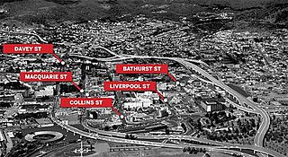
Davey Street a major one way street passing through the outskirts of the Hobart Central business district in Tasmania, Australia. Davey street is named after Thomas Davey, the first Governor of Van Diemen's Land. The street forms a One-way couplet with nearby Macquarie Street connecting traffic from the Southern Outlet in the south with traffic from the Tasman Highway to the east and the Brooker Highway to the north of the city. With Annual average daily traffic of 37,200, the road is one of the busier streets in Hobart.

Sydney central business district Suburb of Sydney, New South Wales, Australia

The Sydney central business district is the main commercial centre of Sydney, the state capital of New South Wales and the most populous city in Australia. It extends southwards for about 3 km (2 mi) from Sydney Cove, the point of first European settlement in which the Sydney region was initially established. Due to its pivotal role in Australia's early history, it is one of the oldest established areas in the country.

Macquarie Street, Hobart street in Hobart, Tasmania, Australia

Macquarie Street a major one way street passing through the outskirts of the Hobart Central business district in Tasmania, Australia. Macquarie street is named after Lachlan Macquarie, who oversaw the planning of Hobart’s inner city grid layout. The street forms a One-way couplet with nearby Davey Street connecting traffic from the Southern Outlet in the south with traffic from the Tasman Highway to the east and the Brooker Highway to the north of the city. With annual average daily traffic of 28,500, the road is one of the busier streets in Hobart.

The modern history of the Australian city of Hobart in Tasmania dates to its foundation as a British colony in 1804. Prior to British settlement, the area had been occupied for at least 8,000 years, but possibly for as long as 35,000 years, by the semi-nomadic Mouheneener tribe, a sub-group of the Nuenonne, or South-East tribe. The descendants of the indigenous Tasmanians now refer to themselves as 'Palawa'.

Elizabeth Street, Hobart road in Hobart

Elizabeth Street is the major street which runs southeast to northwest through the city and suburbs of Hobart, Tasmania, Australia. It was named by the Governor of New South Wales from 1810-1821, Lachlan Macquarie, after his wife Elizabeth Macquarie. It starts at Sullivans Cove and runs northwesterly through the CBD of Hobart and the North Hobart shopping district, and changes to become New Town Road at the intersection with Augusta Road in New Town.

Royal Hobart Regatta

The Royal Hobart Regatta began in 1838, is a series of aquatic competitions and displays held annually in Hobart, Tasmania, Australia and is Tasmania's oldest sporting event. The regatta runs for three days, ending on the second Monday in February, and dominates the whole river for the duration of the event. The regatta of 6 February 1934 was the first to be called the Royal Hobart Regatta, the title being conferred by King George V.

Doone Kennedy Hobart Aquatic Centre aquatic sporting facility in Hobart, Australia

The Doone Kennedy Hobart Aquatic Centre is a major, $17 million aquatic sporting facility located upon the Queens Domain, within less than 1 kilometre of the CBD of Hobart, the capital city of Tasmania, Australia. The venue has hosted the Australian Swimming Championships, the Tasmanian Swimming Championships, FINA Swimming World Cup, Pan Pacific Games and the Qantas Skins. Other major events held at the venue throughout its first seven years of operation include the Australian Canoe Polo Championships, Australian Diving Championships, Australian Water Polo Under Age and National League events and the World and Australian Underwater Hockey Championships.

Hobart Rivulet river in Australia

The Hobart Rivulet, part of the River Derwent catchment, is an urban stream located in the Hobart hinterland and flows through and underneath the city, in Tasmania, Australia.

Trams in Hobart

The Australian city of Hobart, Tasmania’s capital city, no longer has a network of trams operating, but it once had an extensive and popular system that reached the majority of Hobart suburbs. The Hobart tram network was established in 1893 by a private consortium known as the Hobart Electric Tram Company, providing Hobart with the first complete electric tramway in the Southern Hemisphere. Its fleet of double-decker trams were the only such trams in Australia.

Hobart Bypass proposed road in Hobart

The Hobart Bypass is a proposed concept to bypass the Central Business District of Hobart, Tasmania. Currently, through traffic travels from the Tasman/Brooker Highways down the one-way Davey/Macquarie couplet to the Southern Outlet. As well as traffic concerns, there is also a call to build the bypass on the grounds that the current traffic arrangement cuts the central business district off from Hobart's waterfront.

Icon Complex

The ICON Complex is a low rise building in Hobart, Tasmania, situated in the city's centre. ICON Complex utilises access from of two main street fronts, Murray and Liverpool. The Myer department store is situated on Liverpool Street, replacing the Myer lost on the same site in 2007. The Liverpool Street site consists of the ICON Complex shopping centre, boasting many national and international brands including MECCA MAXIMA and Scotch and Soda (Clothing).

Liverpool Street, Hobart street in Hobart, capital city of the state of Tasmania in Australia

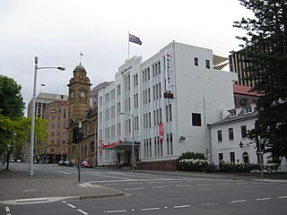
Liverpool Street is a street in the Central Business District of Hobart, in the state of Tasmania.

Argyle Street, Hobart road in Tasmania, Australia

Argyle Street is a street in Hobart, Tasmania. The street was named by Lachlan Macquarie either in reference to Argyll, Scotland, where he grew up, or for the Duke of Argyll, head of Clan Campbell. Lachlan's wife had been born Elizabeth Campbell.

References

  1. 1 2 "2006 Census QuickStats : Hobart (C) - Inner (Statistical Local Area)". Australian Bureau of Statistics. 2006. Retrieved 2014-01-04.
  2. "Affordable Housing Strategy 2010-2012". Hobart City Council. 2010. Retrieved 2014-01-04.
  3. "Hobart- A world class, liveable waterfront city" (PDF). Government of Tasmania. 2010. Retrieved 2014-01-04.
  4. "Home". Hobart City Council . Retrieved 2014-01-04.
  5. "Central Area Provisions Background Report" (PDF). Hobart City Council . Retrieved 2014-01-04.
  6. "Builders named for two new towers of the Royal Hobart Hospital". The Mercury . Retrieved 2014-01-04.
  7. "Supporting Assessment Information" (PDF). Hobart City Council . Retrieved 2014-01-04.
  8. "Devastating Myer fire leaves Hobart reeling". The Age . Retrieved 2014-01-04.
  9. "Icon Complex". Kik group. Retrieved 2014-01-04.

Coordinates: 42°52′50″S147°19′30″E / 42.88056°S 147.32500°E / -42.88056; 147.32500