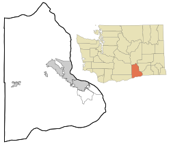
Benton County is a county in the south-central portion of the U.S. state of Washington. As of the 2010 census, its population was 175,177. The county seat is Prosser, and its largest city is Kennewick. The Columbia River demarcates the county's north, south, and east boundaries.

The Horse Heaven Hills are a long range of high, rolling hills in Klickitat, Yakima, and Benton counties in Washington. The hills are an anticline ridge in the Yakima Fold Belt formed by north–south compression of lava flows in the Columbia River Basalt Group. The highest point is Bickleton Ridge in the west end of the hills. They lie within the rain shadow to the east of the Cascade Range, making them significantly drier and hotter than regions west of the Cascades.

Apricot is an unincorporated community in Benton County, Washington, United States, located between Prosser and Grandview.

Artesian is an unincorporated community in Yakima County, Washington, United States, located approximately one mile east of Moxee.
Ashue is an unincorporated community in Yakima County, Washington, United States, located approximately two mile southwest of Wapato.
Blackrock also known as Black Rock is an unincorporated community in Yakima County, Washington, United States, located approximately twelve miles north of Sunnyside.
Midvale is an unincorporated community in Yakima County, Washington, United States, located immediately south of Sunnyside.
Byron is an unincorporated community in Yakima County, Washington, United States, located approximately three miles west of Prosser.
Birchfield is an unincorporated community in Yakima County, Washington, United States, located between Terrace Heights and Moxee.

Cliffdell is an unincorporated community in Yakima County, Washington, United States, located approximately 23 miles west of Ellensburg.
Nile is a census-designated place and unincorporated community in Yakima County, Washington, United States, located approximately 35 miles northwest of Yakima in the Nile Valley adjacent to the Naches River in the Nile Valley, near the mouth of Rattlesnake Creek.
Pomona is an unincorporated community in Yakima County, Washington, United States, located immediately northeast of Selah.
Rimrock is an unincorporated community in Yakima County, Washington, United States, located approximately 22 miles west of Yakima on the Tieton River, adjacent to Rimrock Lake.
Badger is an unincorporated community in Benton County, Washington, United States, located approximately three miles southwest of Richland, near Badger Springs and Badger Canyon.
Chaffee is an unincorporated community in Benton County, Washington, United States, located approximately five miles west of Benton City on the north bank of the Yakima River.
Richland Junction is a neighborhood of Richland in Benton County, Washington, United States. It is located within the east city limits of Richland.

Gibbon is an unincorporated community in Benton County, Washington, United States, between Prosser and Benton City.
Kinneyville was an unincorporated community in Benton County, Washington, United States, and is now a part of Prosser.
North Prosser is an unincorporated community in Benton County, Washington, United States, located approximately one mile north of Prosser.
Whitcomb is an unincorporated community in Benton County, Washington, United States, located approximately 22 miles south of Prosser on the north bank of the Columbia River on the south side of Canoe Canyon.