
Chengde, formerly known as Jehol and Rehe, is a prefecture-level city in Hebei province, situated northeast of Beijing. It is best known as the site of the Mountain Resort, a vast imperial garden and palace formerly used by the Qing emperors as summer residence. The permanent resident population is approximately 3,473,200 in 2017.

Kittatinny Mountain is a long ridge traversing across northwestern New Jersey running in a northeast-southwest axis, a continuation across the Delaware Water Gap of Pennsylvania's Blue Mountain Ridge. It is the first major ridge in the far northeastern extension of the Ridge and Valley province of the Appalachian Mountains, and reaches its highest elevation, 1,803 feet, at High Point in Montague Township. Kittatinny Mountain forms the eastern side of Wallpack Valley; the western side comprises the Wallpack Ridge (highest elevation: 928 feet above sea level.

Chenzhou is a prefecture-level city located in the south of Hunan province, China. Its administrative area covers 19,317 square kilometres (7,458 sq mi), 9.2% of the provincial area, and its total population reached 4,559,600 in 2001, 26% of them living in urban areas, 74% of them live in rural areas.
François Lake Provincial Park is a provincial park in British Columbia, Canada, located at the east end of Francois Lake. Total park area is 7,214 hectares. It is about 12 km off BC Highway 16, southwest of the town of Fraser Lake. There is no potable water at the site so campers should bring their own.
Hont is a village in Nógrád County in Hungary.
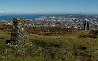
Black Mountain is a large hill which overlooks the city of Belfast, Northern Ireland.

The Gogebic Range is an elongated area of iron ore deposits located within a range of hills in northern Michigan and Wisconsin just south of Lake Superior. It extends from Lake Namakagon in Wisconsin eastward to Lake Gogebic in Michigan, or almost 80 miles. Though long, it is only about a half mile wide and forms a crescent concave to the southeast. The Gogebic Range includes the communities of Ironwood in Michigan, plus Mellen and Hurley in Wisconsin.

The Shenandoah Valley AVA is an American Viticultural Area located in the Shenandoah Valley of Virginia and West Virginia. The valley is bounded by the Blue Ridge Mountains to the east and the Appalachian and Allegheny Plateaus to the west. Most of the AVA is in Virginia, with a small portion in the Eastern Panhandle of West Virginia. Most of the vineyards in the AVA are located in Virginia and grow a wide variety of Vitis vinifera, Vitis labrusca, and French hybrid grapes. The hardiness zone is mainly 6b except for some 7a closer to the mouth of the Shenandoah.

Alander Mountain, 2,239 feet (682 m), is a prominent peak of the south Taconic Mountains; it is located in southwest Massachusetts and adjacent New York. Part of the summit is grassy and open and part is covered with scrub oak and shrubs; the sides of the mountain are wooded with northern hardwood tree species. Views from the top include the southern Taconic Mountains, the Hudson River Valley including the Catskills. Several trails traverse Alander Mountain, most notably the 15.7 mi (25.3 km) South Taconic Trail, which passes just beneath the summit.

Hunt's Hill is a former mining camp in Nevada County, California, United States. Hunt's Hill was located in the Sierra Nevada foothills about 6 miles in a straight line southeast of Nevada City and about 2 miles northwest of You Bet, on the north side of Greenhorn Creek, not far from the present intersection of Red Dog and Buckeye Roads. Hunt’s Hill was founded in 1852 by a miner named Hunt. It was located on one of the deepest parts of the rich Blue Lead channel of gold-bearing gravel. In 1855, one of the mining claims established by some French miners, was “jumped". During the fight, one of the French miners lost an eye. Thereafter, that mine, and sometimes the town, were called Gouge Eye. By 1857, the town boasted two saloons, a hotel, a blacksmith and stable, a butcher shop, a boot and shoe store, and several grocery stores. In 1858, a stage line from Nevada City arrived. In 1866, seven cement mills for extracting gold from the “blue cement” were operating in the area. By 1880, the town was reduced to a combined store and saloon and a few houses. In 1895, one directory summed up the state of the community thus: "At the present time there is not much doing there." Since that same directory identified the town's justice of the peace and constable, what little happened must have been interesting. Today, it is just a historic site.

The New River Mountains are a small 14-mi (23 km) long, mountain range in central Arizona, and on the north border of the Phoenix valley; the range is located on the southwest perimeter of the Arizona transition zone. The range is a sub-part of landforms extending south from the Black Hills of Yavapai County. Rivers and canyons border east and west; the south of the range is located in Maricopa County, the location of much of the Phoenix metropolitan area.

Poston Butte is a hill located along Hunt Highway in Florence, Pinal County, Arizona, United States, near the eastern end of the Santan Mountains. Geologically, it is characterized by basalts overlying altered granite.

Gross Hill is a mountain in the Central New York Region of New York. It is located northwest of Garrattsville, New York. Crystal Lake is located south and Wooley Hill is located northeast of Gross Hill.

Fox Hill is a mountain located in Adirondack Mountains of New York located in the Town of Indian Lake east of Indian Lake.
Wilders Hill is a mountain located in Central New York Region of New York east of Richfield Springs, New York. Waiontha Mountain is located southeast of Wilders Hill.
Red Hill is a mountain located in the Catskill Mountains of New York east-south of Frost Valley. Woodhull Mountain is located northeast of Red Hill.
Van Loan Hill is a mountain in Greene County, New York. It is located in the Catskill Mountains southwest of Maplecrest. Round Hill is located west, Elm Ridge is located north-northeast, and East Jewett Range is located south of Van Loan Hill.
Steam Sawmill Hill is a mountain in Chenango County, New York. It is located south-southwest of Sherburne. Hunts Mountain is located northeast, Sugarloaf Mountain is located east, and Tinker Ridge is located southwest of Steam Sawmill Hill.
Hunts Mountain is a mountain in Chenango County, New York. It is located southeast of Sherburne. Steam Sawmill Hill is located southwest, Sugarloaf Mountain is located south-southeast, and Church Hill is located northwest of Hunts Mountain.


