Hyannis, Nebraska | |
---|---|
Coordinates: 42°00′02″N101°45′44″W / 42.00056°N 101.76222°W | |
Country | United States |
State | Nebraska |
County | Grant |
Area | |
• Total | 0.52 sq mi (1.35 km2) |
• Land | 0.52 sq mi (1.35 km2) |
• Water | 0.00 sq mi (0.00 km2) |
Elevation | 3,757 ft (1,145 m) |
Population (2020) | |
• Total | 165 |
• Density | 316.70/sq mi (122.31/km2) |
Time zone | UTC-7 (Mountain (MST)) |
• Summer (DST) | UTC-6 (MDT) |
ZIP code | 69350 |
Area code | 308 |
FIPS code | 31-23655 [3] |
GNIS feature ID | 2398566 [2] |
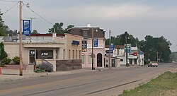
Hyannis is a village in Grant County, Nebraska, United States. The population was 165 at the time of the 2020 census. It is the county seat of Grant County. [4] It is centrally located in the extensive, unique, and remote region of grasslands known as the Sandhills of Nebraska at the intersection of two Nebraska State Highways: NSH 61 which runs north and south, and NSH 2, which runs east and west.
Hyannis was laid out in 1888 when the Chicago, Burlington and Quincy Railroad was extended to that point. [5] It was named after the village of Hyannis, Massachusetts by a railroad official. [6] [7]
Hyannis is served by a Panhandle Trails intercity bus thrice daily Monday through Friday. [8]
Hyannis is located in the Nebraska Sandhills. According to the United States Census Bureau, the village has a total area of 0.52 square miles (1.35 km2), all land. [9]
Census | Pop. | Note | %± |
---|---|---|---|
1910 | 262 | — | |
1920 | 384 | 46.6% | |
1930 | 384 | 0.0% | |
1940 | 449 | 16.9% | |
1950 | 432 | −3.8% | |
1960 | 373 | −13.7% | |
1970 | 345 | −7.5% | |
1980 | 336 | −2.6% | |
1990 | 210 | −37.5% | |
2000 | 287 | 36.7% | |
2010 | 182 | −36.6% | |
2020 | 165 | −9.3% | |
U.S. Decennial Census [10] |
As of the census [11] of 2010, there were 182 people, 98 households, and 61 families residing in the village. The population density was 350.0 inhabitants per square mile (135.1/km2). There were 132 housing units at an average density of 253.8 per square mile (98.0/km2). The racial makeup of the village was 97.8% White and 2.2% from two or more races. Hispanic or Latino of any race were 1.6% of the population.
There were 98 households, of which 12.2% had children under the age of 18 living with them, 56.1% were married couples living together, 4.1% had a female householder with no husband present, 2.0% had a male householder with no wife present, and 37.8% were non-families. 33.7% of all households were made up of individuals, and 15.3% had someone living alone who was 65 years of age or older. The average household size was 1.86 and the average family size was 2.30.
The median age in the village was 54.2 years. 12.1% of residents were under the age of 18; 4.9% were between the ages of 18 and 24; 14.2% were from 25 to 44; 38.3% were from 45 to 64; and 30.2% were 65 years of age or older. The gender makeup of the village was 50.0% male and 50.0% female.
As of the census [3] of 2000, there were 287 people, 116 households, and 88 families residing in the village. The population density was 422.8 inhabitants per square mile (163.2/km2). There were 165 housing units at an average density of 243.1 per square mile (93.9/km2). The racial makeup of the village was 98.61% White, 1.39% from other races. Hispanic or Latino of any race were 2.79% of the population.
There were 116 households, out of which 36.2% had children under the age of 18 living with them, 64.7% were married couples living together, 9.5% had a female householder with no husband present, and 23.3% were non-families. 23.3% of all households were made up of individuals, and 9.5% had someone living alone who was 65 years of age or older. The average household size was 2.47 and the average family size was 2.91.
In the village, the population was spread out, with 28.2% under the age of 18, 5.6% from 18 to 24, 24.7% from 25 to 44, 26.5% from 45 to 64, and 15.0% who were 65 years of age or older. The median age was 41 years. For every 100 females, there were 111.0 males. For every 100 females age 18 and over, there were 102.0 males.
As of 2000 the median income for a household in the village was $29,688, and the median income for a family was $35,313. Males had a median income of $26,000 versus $13,906 for females. The per capita income for the village was $13,906. About 4.7% of families and 6.0% of the population were below the poverty line, including 9.1% of those under the age of eighteen and none of those 65 or over.
Ayr is a village in Adams County, Nebraska, United States. The population was 94 at the 2010 census. It is part of the Hastings, Nebraska Micropolitan Statistical Area.
Brunswick is a village in Antelope County, Nebraska, United States. The population was 138 at the 2010 census.
Riverdale is a village in Buffalo County, in the state of Nebraska, in the Midwestern United States. It is part of the Kearney, Nebraska Micropolitan Statistical Area. The population was 182 at the 2010 census.
Bellwood is a village in Butler County, Nebraska, United States. The population was 435 at the 2010 census.
Bruno is a village in Butler County, Nebraska, United States. The population was 99 at the 2010 census.
Garrison is a village in Butler County, Nebraska, United States. The population was 54 at the 2010 census.
Avoca is a village in Cass County, Nebraska, United States. The population was 178 at the 2020 census.
Mason City is a village in Custer County, Nebraska, United States. The population was 171 at the 2010 census.
Pickrell is a village in Gage County, Nebraska, United States. As of the 2020 census, the village population was 186.
Phillips is a village in Hamilton County, Nebraska, United States. The population was 287 at the 2010 census.
Page is a village in Holt County, Nebraska, United States. The population was 166 at the 2010 census.
Bazile Mills is a village in Knox County, Nebraska, United States. The population was 24 at the 2020 census.
Winnetoon is a village in Knox County, Nebraska, United States. The population was 68 at the 2010 census.
Unadilla is a village in Otoe County, Nebraska, United States. The population was 296 at the 2020 census.
Cedar Bluffs is a village in Saunders County, Nebraska, United States. The population was 615 at the 2020 census. Cedar Bluffs was a point on the Mormon, Oregon, and California Trails.
Valparaiso is a village in Saunders County, Nebraska, United States. The population was 595 at the 2020 census.
Bee is a village in Seward County, Nebraska, United States. It is part of the Lincoln, Nebraska Metropolitan Statistical Area. The population was 191 at the 2010 census.
Gilead is a village in Thayer County, Nebraska, United States. The population was 32 at the 2020 census.
Emerson is a village in Dakota, Dixon, and Thurston counties in Nebraska, United States. The population was 840 at the 2010 census. Emerson is the only community in Nebraska that exists in three counties.
Oxford is a village in Furnas and Harlan counties in the U.S. state of Nebraska. The population was 779 at the 2010 census.
Media related to Hyannis, Nebraska at Wikimedia Commons