
The following is an alphabetical list of topics related to the Marshall Islands.
The following is an alphabetical list of topics related to the Marshall Islands.


The Marshall Islands, officially the Republic of the Marshall Islands, is an island country west of the International Date Line and north of the equator in the Micronesia region in the Northwestern Pacific Ocean. The territory consists of 29 coral atolls and five islands, divided across two island chains: Ratak in the east and Ralik in the west. 97.87% of its territory is water, the largest proportion of water to land of any sovereign state. The country shares maritime boundaries with Wake Island to the north, Kiribati to the southeast, Nauru to the south, and the Federated States of Micronesia to the west. The capital and largest city is Majuro, home to approximately half of the country's population.
Austronesian settlers arrived in the Marshall Islands in the 2nd millennium BC, but there are no historical or oral records of that period. Over time, the Marshallese people learned to navigate over long ocean distances by walap canoe using traditional stick charts.
The flag of the Marshall Islands, an island nation in the Pacific, was adopted upon the start of self-government, May 1, 1979. The flag was designed by Emlain Kabua, who served as the first First Lady of the republic.

The Ratak Chain is a chain of islands and atolls within the island nation of the Marshall Islands. Ratak means "sunrise". It lies to the east of the country's other island chain, the Ralik Chain. In 1999, the total population of the Ratak islands was 30,925.
The Ralik Chain is a chain of islands within the island nation of the Marshall Islands. Ralik means "sunset". It is west of the Ratak Chain. In 1999 the total population of the Ralik islands was 19,915. Christopher Loeak, who became President of the Marshall Islands in 2012, was formerly Minister for the Ralik Chain.
The Maloelap Atoll is a coral atoll of 71 islands in the Pacific Ocean, and forms a legislative district of the Ratak Chain of the Marshall Islands. Its land area is only 9.8 square kilometers (3.8 sq mi), but that encloses a lagoon of 972 square kilometers (375 sq mi). It is located 18 kilometers (11 mi) north of the atoll of Aur. The population of the atoll was 395 at the 2021 census.

Rongerik Atoll or Rongdrik Atoll is an unpopulated coral atoll of 17 islands in the Pacific Ocean, and is located in the Ralik Chain of the Marshall Islands, approximately 200 kilometers (120 mi) east of Bikini Atoll. Its total land area is only 1.68 square kilometers (0.65 sq mi), but it encloses a lagoon of 144 square kilometers (56 sq mi).
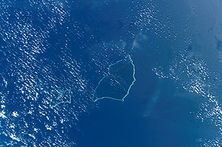
Aur Atoll is a coral atoll of 42 islands in the Pacific Ocean, and forms a legislative district of the Ratak Chain of the Marshall Islands. Its total land area is only 15 square kilometers (5.6 sq mi), but it encloses a lagoon with an area of 620 square kilometers (240 sq mi). It is located south of Maloelap Atoll. The population of Aur Atoll was 317 in 2021.

Likiep Atoll is a coral atoll of 65 islands in the Pacific Ocean, and forms a legislative district of the Ratak Chain of the Marshall Islands. It is approximately 55 kilometers (34 mi) northwest of Wotje. Its total land area is only 10.26 square kilometers (3.96 sq mi), but that encloses a deep central lagoon of 424 square kilometers (164 sq mi). Likiep Atoll also possesses the Marshall Islands' highest point, an unnamed knoll 10 meters (33 ft) above sea level. The population of Likiep Atoll was 228 in 2021.

Namdrik Atoll or Namorik Atoll is a coral atoll of two islands in the Pacific Ocean, and forms a legislative district of the Ralik Chain of the Marshall Islands. Its total land area is only 2.8 square kilometers (1.1 sq mi), but it encloses a lagoon with an area of 8.4 square kilometers (3.2 sq mi). The atoll had a population of 299 at the 2021 census.

Utirik Atoll or Utrik Atoll is a coral atoll of 10 islands in the Pacific Ocean, and forms a legislative district of the Ratak Chain of the Marshall Islands. Its total land area is only 2.4 square kilometers (0.94 sq mi), but it encloses a lagoon with an area of 57.7 square kilometers (22.29 sq mi). It is located approximately 47 kilometers (29 mi) east of Ujae Atoll. The population of Utirik Atoll was 264 at the 2021 census. It is one of the northernmost Marshall Islands with permanent habitation.

Bikar Atoll is an uninhabited atoll in the Ratak Chain of the Marshall Islands. It is one of the smallest atolls in the Marshalls. Due to its relative isolation from the main islands in the group, Bikar's flora and fauna has been able to exist in a relatively pristine condition.
The following outline is provided as an overview of and topical guide to the Marshall Islands:
ISO 3166-2:MH is the entry for the Marshall Islands in ISO 3166-2, part of the ISO 3166 standard published by the International Organization for Standardization (ISO), which defines codes for the names of the principal subdivisions of all countries coded in ISO 3166-1.
Japanese settlement in the Marshall Islands was spurred on by Japanese trade in the Pacific region. The first Japanese explorers arrived in the Marshall Islands in the late 19th century, although permanent settlements were not established until the 1920s. As compared to other Micronesian islands in the South Seas Mandate, there were fewer Japanese who settled in the islands. After the Japanese surrender in 1945, the Japanese populace were repatriated to Japan, although people of mixed Japanese–Marshallese heritage remained behind. They form a sizeable minority in the Marshall Islands' populace, and are well represented in the corporate, public and political sectors in the country.

Republic of Marshall Islands Public School System (PSS) is the public school system of the Marshall Islands, headquartered in Majuro. It was established in November 2013 by Public Law 2013-23.
Northern Islands High School (NIHS) is a secondary school in Wotje, Marshall Islands. It is a part of the Marshall Islands Public School System.

Marshallese cuisine comprises the fare, foods, beverages and foodways of the Marshall Islands, including its food-related customs and traditions. Common indigenous and traditional foods include breadfruit, coconut, bananas, papaya, seafood, pandanus and bwiro. Additional imported foods, such as rice and flour, are also a part of people's diets and contribute to the cuisine as well. The practice of food preservation is a part of the history of the islands, and continues to occur today.

Naval Base Marshall Islands were United States Navy advance bases built on the Marshall Islands during World War II to support the Pacific War efforts. The bases were built by US Navy after the Marshall Islands campaign that captured the islands from the Empire of Japan. By February 1944 the United States Armed Forces had captured the islands. Most of the airfields and other facilities Japan had built were destroyed in allied bombing raids and naval bombardment. US Navy Seabee Construction Battalions arrived as soon as the area was secured and remove the debris. The Seabees quickly repaired, built and improved the airfield/runways and seaport. Seabees often worked around the clock to get airfields operational so that fighter aircraft and bombers could start operating. The bases were used for staging upcoming campaigns and for repair.
