Ise, Mie

Last updated • 14 min readFrom Wikipedia, The Free Encyclopedia
Ise
伊勢市
Uji-bashi 03.JPG
Meoto Iwa rocks 02.jpg
Kongoshoji(Mie) 08.JPG
Oharaimachi-dori Street 20190130-2.jpg
Ise city.JPG
From top, left to right: Ise Grand Shrine, the Wedded Rocks, Kongōshō Temple, Oharaimachi, and Okage Yokocho
Flag of Ise, Mie.svg
Emblem of Ise, Mie.svg
Ise, Mie
Ise in Mie Prefecture Ja.svg
Location of Ise in Mie Prefecture
Japan location map with side map of the Ryukyu Islands.svg
Red pog.svg
Ise
 
Coordinates: 34°29′N136°43′E / 34.483°N 136.717°E / 34.483; 136.717
Country Japan
Region Kansai
Prefecture Mie
As Uji-Yamada citySeptember 1, 1906
As Ise cityJanuary 1, 1955
Government
  MayorKen'ichi Suzuki
Area
  Total
208.52 km2 (80.51 sq mi)
Population
 (July 2021)
  Total
123,533
  Density590/km2 (1,500/sq mi)
Time zone UTC+9 (Japan Standard Time)
Phone number0596-23-1111
Address1-7-29 Iwabuchi, Ise-shi, Mie-ken 516-0037
Climate Cfa
Website Official website
Symbols
Flower Oyane-zakura
Tree Michelia compressa
Ise City Hall Ise cityhall.jpg
Ise City Hall

Ise (Japanese: 伊勢市, Hepburn: Ise-shi), formerly called Ujiyamada (宇治山田), is a city in central Mie Prefecture, on the island of Honshū, Japan. Ise is home to Ise Grand Shrine, the most sacred Shintō shrine in Japan. The city has a long-standing title – Shinto (神都) – that roughly means "the Holy City", and literally means "the Capital of the Kami ". [1] As of 31 July 2021, the city had an estimated population of 123,533 in 55,911 households and a population density of 590 people per km². [2] The total area of the city is 208.53 square kilometres (80.51 sq mi).

Contents

Geography

Ise is located on the northern half of Shima Peninsula in far eastern Mie Prefecture. The northern part of the city is flat land and faces Ise Bay on the Pacific Ocean. In the south, the land rises to form hills and mountains with an elevation of 100 to 500 meters. Most of the city is within the geographic limits of Ise-Shima National Park.

Neighboring municipalities

Mie Prefecture

Climate

Ise has a Humid subtropical climate (Köppen Cfa) characterized by warm summers and cool winters with light to no snowfall. The average annual temperature in Ise is 15.6 °C (60.1 °F). The average annual rainfall is 1,870.8 mm (73.65 in), with September as the wettest month. The temperatures are highest on average in August, at around 27.2 °C (81.0 °F), and lowest in January, at around 4.8 °C (40.6 °F). [3]

Climate data for Obata, Ise (1991−2020 normals, extremes 1979−present)
MonthJanFebMarAprMayJunJulAugSepOctNovDecYear
Record high °C (°F)18.1
(64.6)
20.5
(68.9)
25.3
(77.5)
30.7
(87.3)
33.1
(91.6)
36.0
(96.8)
38.5
(101.3)
38.8
(101.8)
37.8
(100.0)
30.4
(86.7)
25.6
(78.1)
25.4
(77.7)
38.8
(101.8)
Mean daily maximum °C (°F)9.5
(49.1)
10.2
(50.4)
13.8
(56.8)
19.4
(66.9)
24.0
(75.2)
26.8
(80.2)
31.0
(87.8)
32.2
(90.0)
28.3
(82.9)
22.7
(72.9)
17.1
(62.8)
11.9
(53.4)
20.6
(69.0)
Daily mean °C (°F)4.8
(40.6)
5.2
(41.4)
8.5
(47.3)
13.8
(56.8)
18.7
(65.7)
22.2
(72.0)
26.3
(79.3)
27.2
(81.0)
23.7
(74.7)
17.9
(64.2)
12.1
(53.8)
7.0
(44.6)
15.6
(60.1)
Mean daily minimum °C (°F)0.2
(32.4)
0.5
(32.9)
3.3
(37.9)
8.4
(47.1)
13.9
(57.0)
18.4
(65.1)
22.6
(72.7)
23.4
(74.1)
19.9
(67.8)
13.6
(56.5)
7.2
(45.0)
2.2
(36.0)
11.1
(52.0)
Record low °C (°F)−5.7
(21.7)
−6.0
(21.2)
−3.9
(25.0)
−1.8
(28.8)
4.8
(40.6)
10.0
(50.0)
15.7
(60.3)
16.0
(60.8)
10.2
(50.4)
3.1
(37.6)
−1.7
(28.9)
−4.9
(23.2)
−6.0
(21.2)
Average precipitation mm (inches)63.3
(2.49)
68.3
(2.69)
121.3
(4.78)
134.2
(5.28)
188.1
(7.41)
213.7
(8.41)
181.7
(7.15)
160.2
(6.31)
319.2
(12.57)
258.4
(10.17)
95.8
(3.77)
66.6
(2.62)
1,870.8
(73.65)
Average precipitation days (≥ 1.0 mm)5.45.99.69.610.312.611.38.911.310.66.55.6107.6
Mean monthly sunshine hours 173.1163.3182.2190.5191.1137.3174.8208.2150.1157.9159.4174.72,059.8
Source: Japan Meteorological Agency [4] [3]

Demographics

Per Japanese census data, [5] the population of Ise has remained relatively steady over the past 50 years.

Historical population
YearPop.±%
1960 123,311    
1970 130,339+5.7%
1980 137,296+5.3%
1990 138,298+0.7%
2000 136,173−1.5%
2010 130,228−4.4%

History

Ise's history is directly linked to that of Ise Grand Shrine. Ise Grand Shrine is separated into two main parts: The Inner Shrine and the Outer Shrine. Despite the names, these are actually two physically separate shrines approximately six kilometers apart. Ise began with small settlements that had sprung up around the two shrines. During the Edo period, Ise was a major destination for pilgrimages which were called "o-Ise-mairi" (literally, "Coming to Ise") and thus, these settlements grew larger and developed into small villages. The village around the Inner Shrine was named Uji, and the village around the Outer Shrine was named Yamada. Because of the religious importance of Ise Grand Shrine, the Tokugawa shogunate during the Edo period viewed the area as politically significant and installed a magistrate in Yamada.

During the Meiji period, these two villages were merged with the establishment of the modern municipal system to form the town of Ujiyamada. The town was upgraded to city status on September 1, 1906. In 1909, the forerunner to the JNR connected Ujiyamada by train, followed by the forerunner of Kintetsu Railway in 1930. These lines were responsible for a large increase in pilgrims and tourists visiting Ise Grand Shrine, peaking with an estimated eight million visitors in the year 1940, per government-sponsored ceremonies celebrating the 2600th anniversary of the foundation of the Japanese empire. The significance of the Ise Grand Shrine to State Shinto made Ujiyamada a target for six air raids during World War II, the largest of which was on July 28, 1945 when 93 Twentieth Air Force Boeing B-29 Superfortress bombers dropped incendiaries, burning 39% of the city. [6]

On January 1, 1955 Ujiyamada absorbed the villages of Toyohama, Kitahama, Shigō and Kida and was renamed Ise City. The reason for this change is to avoid naming confusion with the later-formed cities of Uji in Kyōto Prefecture and the city of Yamada (now the city of Kama) in Fukuoka Prefecture. The name "Ise" was chosen because it was already recognized throughout Japan due to Ise Grand Shrine. However, the renaming phase took some time around the city. For example, it took four years to rename the main JR station in town, Yamada Station, to Iseshi Station. Some things were never renamed, such as Ujiyamada Station, Ise's largest train station, and Ujiyamada High School, Ise's first high school.

On September 26, 1959: The Ise-wan Typhoon, Japan's strongest-recorded typhoon, hit Ise and surrounding areas.

On November 1, 2005: Ise absorbed the towns of Futami and Obata and the village of Misono (all from Watarai District).

Government

Ise has a mayor-council form of government with a directly elected mayor and a unicameral city council of 28 members. Ise contributes four members to the Mie Prefectural Assembly. In terms of national politics, the city is part of Mie 4th district of the lower house of the Diet of Japan.

Economy

Products

Industry

Factories

Education

Ise has 23 public elementary schools and ten public middle schools operated by the city government and six public high schools operated by the Mie Prefectural Department of Education. The city also has one private middle school and four private high schools. The Shinto-affiliated Kogakkan University is located in Ise.

Transportation

Railway

Ise is easily accessible by rail due to the popularity of Ise Grand Shrine as a tourist attraction. Kintetsu offers direct service to Ise from Kyoto, Osaka and Nagoya in the form of regular express trains (once or twice an hour) and limited express trains (usually twice an hour). The ride from Osaka takes about 135 minutes (105 minutes on the limited express), the ride from Nagoya takes about 100 minutes (85 minutes on the limited express). JR Central, offers direct service to Ise from Nagoya once an hour on the Mie Rapid, which takes about 90 minutes.

Lines and stations

KintetsuLogo.svg Kintetsu Railway - Yamada Line

KintetsuLogo.svg Kintetsu Railway - Toba Line

JR logo (central).svg JR Tōkai - Sangū Line

Bus

Sanco operates a number of buses to and through Ise. The main bus hub in town is in front of the JR exit of Iseshi Station. Sanco used to manage a tram service around Ise, in particular a line called the "Shinto Line" that ran from Iseshi Station to the Inner Shrine. It was closed in 1961 and was replaced by buses.

Roads

Expressways

Toll roads

National Routes

Air

Ise has a direct ferry link to Central Japan International Airport.

Local attractions

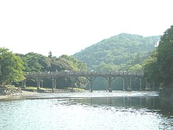
Uji Bridge, entrance to the Inner Shrine Uji-bashi 01.JPG
Uji Bridge, entrance to the Inner Shrine
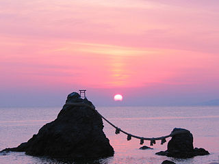
Meoto Iwa, the "wedded rocks" at high tide The Wedded Rocks.JPG
Meoto Iwa, the "wedded rocks" at high tide
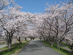
Miya River cherry blossoms Miya River Sakura.jpg
Miya River cherry blossoms
Geku-Sando Street Geku-Sando Street 20190130-1.jpg
Geku-Sando Street

Festivals

Notable people

Related Research Articles

<span class="mw-page-title-main">Mie Prefecture</span> Prefecture of Japan

Mie Prefecture is a prefecture of Japan located in the Kansai region of Honshu. Mie Prefecture has a population of 1,781,948 and has a geographic area of 5,774 square kilometers (2,229 sq mi). Mie Prefecture is bordered by Gifu Prefecture to the north, Shiga Prefecture and Kyoto Prefecture to the northwest, Nara Prefecture to the west, Wakayama Prefecture to the southwest, and Aichi Prefecture to the east.
<span class="mw-page-title-main">Shima Province</span> Former province of Japan

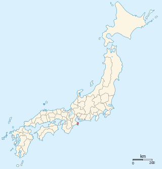
Shima Province was a province of Japan which consisted of a peninsula in the southeastern part of modern Mie Prefecture. Its abbreviated name was Shishū (志州). Shima bordered on Ise Province to the west, and on Ise Bay on the north, east and south. It roughly coincides with the modern municipalities of Shima and Toba.

<span class="mw-page-title-main">Ise Province</span> Former province of Japan

Ise Province was a province of Japan in the area of Japan that is today includes most of modern Mie Prefecture. Ise bordered on Iga, Kii, Mino, Ōmi, Owari, Shima, and Yamato Provinces. Its abbreviated form name was Seishū (勢州).

<span class="mw-page-title-main">Nagoya Line (Kintetsu)</span> Railway line in Japan

The Nagoya Line is a railway line owned and operated by the Kintetsu Railway, a Japanese private railway company, connecting Nagoya and Ise Nakagawa Station in Matsusaka, Mie Prefecture via Kuwana, Yokkaichi, Suzuka, Tsu municipalities along the Ise Bay. The official starting-point of the line is Ise-Nakagawa and the terminus is Nagoya; however, operationally trains run "down" from and "up" towards Nagoya.

<span class="mw-page-title-main">Ise Shrine</span> Shinto shrine in Japan

The Ise Shrine, located in Ise, Mie Prefecture of Japan, is a Shinto shrine dedicated to the solar goddess Amaterasu. Also known simply as Jingū (神宮), Ise Shrine is a shrine complex composed of many Shinto shrines centered on two main shrines, [Naikū] Error: {{nihongo}}: transliteration text not Latin script (help) (内宮) and [Gekū] Error: {{nihongo}}: transliteration text not Latin script (help) (外宮).

<span class="mw-page-title-main">Meoto Iwa</span> Type of sacred rocks in Shinto

Meoto Iwa (夫婦岩), or Married Couple Rocks, are a kind of rock formation seen as religiously significant in Shinto. They are a subtype of Iwakura rock.

<span class="mw-page-title-main">Yamada Line (Kintetsu)</span> Railway line in Japan

The Yamada Line is a railway line of the Japanese private railway company Kintetsu Railway, connecting Ise-Nakagawa Station and Ujiyamada Station in Japan. The line runs parallel to parts of the JR Central Kisei Main Line and Sangū Line.

<span class="mw-page-title-main">Ujiyamada Station</span> Railway station in Ise, Mie Prefecture, Japan

Ujiyamada Station is a junction railway station located in the city of Ise, Mie Prefecture, Japan, operated by the private operator Kintetsu. It is the closest station to Ise Grand Shrine and thus has an important role for tourists and pilgrims. The station also administrates the section between Kushida Station and Isuzugawa Station.
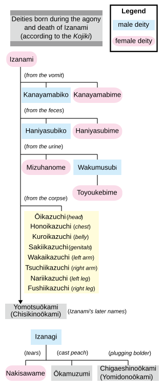
<span class="mw-page-title-main">Toyouke-hime</span> Goddess of agriculture and industry in the Shinto religion

Toyouke-hime is the goddess of agriculture, industry, food, clothing, and houses in the Shinto religion. Originally enshrined in the Tanba region of Japan, she was called to reside at Gekū, Ise Shrine, about 1,500 years ago at the age of Emperor Yūryaku to offer sacred food to Amaterasu Ōmikami, the Sun Goddess.

<span class="mw-page-title-main">Iseshi Station</span> Railway station in Ise, Mie Prefecture, Japan

Iseshi Station is a union passenger railway station located in the city of Ise, Mie Prefecture, Japan, operated by JR Central and the private railway operator Kintetsu Railway.
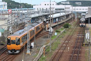
<span class="mw-page-title-main">Toba Line</span> Railway line in Japan

The Toba Line is a railway line operated by the Japanese private railway company Kintetsu Railway, connecting Ujiyamada Station in Ise, Mie with Toba Station in Toba, Mie. The line runs parallel to JR Central's Sangū Line.
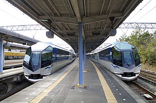
<span class="mw-page-title-main">Shima Line</span>

The Shima Line is a railway line in Mie Prefecture, Japan, operated by private railway operator Kintetsu Railway, connecting Toba Station in Toba with Kashikojima Station in Shima.

<span class="mw-page-title-main">Sangū Line</span> Railway line Mie prefecture, Japan

The Sangū Line is a railway line run by Central Japan Railway Company, connecting Taki Station with Toba Station in Japan.

<span class="mw-page-title-main">Ise Electric Railway</span> Former private railway company in Japan

Ise Electric Railway, usually abbreviated as Iseden (伊勢電), was a private railway company that operated mostly in Mie Prefecture, Japan, for 25 years from 1911 to 1936, when it was absorbed by Sangū Express Electric Railway. At its height, Iseden operated three train lines, two of which it planned and built, that serviced the cities of Yokkaichi, Tsu, Suzuka, Matsusaka, Ujiyamada, and Ōgaki. Much of the infrastructure of Iseden is now owned by Kintetsu and remains in use today.

<span class="mw-page-title-main">Miya River (Mie)</span> River in Japan

The Miya River is a major river that flows through central Mie Prefecture on the island of Honshū, Japan. It is officially classified as a Class 1 river by the Japanese government and is one of four Class 1 rivers that flow solely through Mie; it is the longest among these four.

<i>Mie</i> (train) Japanese rapid train service

The Mie (みえ) is a Rapid train service in Japan operated by Central Japan Railway Company, which runs from Nagoya to Iseshi and Toba. The service passes through several significant locations en route, such as Tsu, the capital city of Mie Prefecture.

<span class="mw-page-title-main">Toyomiyazaki Bunko</span>

The Toyomiyazaki Bunkō (豊宮崎文庫) was a library and academy in the Edo period located in the Okamoto neighborhood of the city of Ise, Mie, Japan. It was an important resource for kokugaku scholars in the Bakumatsu period. Along with the Kanazawa Bunko and Ashikaga Bunko, it was one of the largest and most important collections in pre-modern Japan. The building once housing the collection was designated a National Historic Site of Japan in 1923.
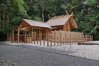
<span class="mw-page-title-main">Izawa-no-miya</span> Shinto shrine in Shima, Mie, Japan

Izawa-no-miya (伊雑宮) is a Shinto shrine in the Kaminogō neighborhood of Isobe in the city of Shima in Mie Prefecture, Japan. It is one of the two shrines claiming the title of ichinomiya of former Shima Province. Together with the Takihara-no-miya (瀧原宮) in Taiki, it is one of the Amaterasu-Ōkami no Tonomiya (天照大神の遙宮), or external branches of the Inner Shrine of the Ise Grand Shrine.

<span class="mw-page-title-main">Izawa-jinja</span> Shinto shrine in Toba, Mie, Japan

Izawa Jinja (伊射波神社) is a Shinto shrine in the Arashima neighborhood of the city of Toba in Mie Prefecture, Japan. It is one of the two shrines claiming the title of ichinomiya of former Shima Province. The main festivals of the shrine are held annually on January 9, June 7 and November 23. It is also referred to as the Shima Daimyōjin (志摩大明神).

<span class="mw-page-title-main">Futami-ga-ura</span> Place in Mie Prefecture, Japan

Futami-ga-ura is a sub-bay or inlet of Ise Bay in Japan, where the Isuzu River enters the bay.

References

  1. In waka rhetoric Makurakotoba , the word Kamikaze was used to introduce Ise.
  2. "Ise city official statistics" (in Japanese). Japan.
  3. 1 2 気象庁 / 平年値(年・月ごとの値). JMA . Retrieved April 11, 2022.
  4. 観測史上1~10位の値(年間を通じての値). JMA . Retrieved April 11, 2022.
  5. Ise population statistics
  6. "USAAF Chronology: COMBAT CHRONOLOGY OF THE US ARMY AIR FORCES, JULY 1945". Archived from the original on 2020-11-13. Retrieved 2008-05-20.

Commons-logo.svg Media related to Ise, Mie at Wikimedia Commons