Jungle tourism

Last updated
Tourists kayaking in Taman Negara, Malaysia. Let's explore.jpg
Tourists kayaking in Taman Negara, Malaysia.

Jungle tourism is a subcategory of adventure travel defined by active multifaceted physical means of travel in the jungle regions of the earth. Although similar in many respects to adventure travel, jungle tourism pertains specifically to the context of region, culture and activity. According to the Glossary of Tourism Terms, jungle tours have become a major component of green tourism in tropical destinations and are a relatively recent phenomenon of Western international tourism.

Contents

Of the regions that take part in tourism-driven sustainable development practices and eco tourism, Mexican, Central and South American practices are the most pervasive in the industry; notably Mayan jungle excursions. Other regions include jungle territories in Africa, Australia, and the South Pacific.

Central and South America

Chichen Itza in Mexico, a World Heritage Site Chichen-Itza-Castillo-Seen-From-East.JPG
Chichen Itza in Mexico, a World Heritage Site
The Tikal in Guatemala Tikalpano.jpg
The Tikal in Guatemala
Copan in Honduras CopanRuins.jpg
Copán in Honduras

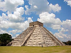
The majority of jungle tour operators are concentrated in what is known as the Mayan World or "Ruta Maya". The Mayan World encompasses five countries that hosted the entirety of the Mayan Civilization: Mexico, Guatemala, Belize, Honduras and El Salvador. Most tours consist of visits to popular Mayan archaeological sites such as Tikal, Guatemala, Chichen Itza, and Copan. These day visits will usually consist of a guided tour of a heavily tourist-concentrated Mayan and archaeological site. Tikal and Chichen Itza are prime examples of popular day-visit sites. Such sites involve a tour guide, designated either by the state government or by a private company, for the tourists. These tour guides are predominantly trained professionals, certified to take large parties of fifty through heavily populated archaeological sites. Nicaragua and Costa Rica are also popular destinations for this type of adventure travel.

Although most of the visits to these more prominent sites involve day trips, there are also many jungle tour operators that showcase less-known, remote Mayan jungle ruins such as Nakum, Yaxha, and El Mirador. These tours involve much more preparation, time and funding to explore as they are usually in very remote and generally inaccessible regions of the Mayan jungles. These ruins and sites are reached by alternative and physically taxing means of travel such as bicycle, canoe, horseback or hiking. This is what essentially differentiates jungle tourism from any other sort of adventure travel tours. There are several tour operators that will employ the use of machetes during tours.

Another difference is that the majority of tour operators that travel deep into the Central and South American jungle will cap the number of persons traveling in the group at ten to fifteen. This is done to minimize the impact on the jungle flora and fauna. Federal laws in some countries prohibit any given group larger than fifteen people traveling through the Mayan jungle, a generally protected region, but limited resources for enforcing such laws have allowed such practices to occur under the radar.

In Guatemala it has become very popular to hike through the jungle of the Mayan Biosphere due to the discovery of El Mirador, also known as the Lost City of Maya. There are no roads. Many take a quick flight from Flores while others hike through the jungles of the department of Petén. Groups should be smaller than 15 people in order to reduce the impact on the environment.

See also

Related Research Articles

<span class="mw-page-title-main">Uxmal</span> Ancient Maya city

Uxmal is an ancient Maya city of the classical period located in present-day Mexico. It is considered one of the most important archaeological sites of Maya culture, along with Palenque, Chichen Itza and Calakmul in Mexico, Caracol and Xunantunich in Belize, and Tikal in Guatemala. It is located in the Puuc region of the western Yucatán Peninsula, and is considered one of the Maya cities most representative of the region's dominant architectural style. It has been designated a UNESCO World Heritage Site in recognition of its significance.

<span class="mw-page-title-main">Coba</span> Pre-Columbian Maya site in the northeastern Yucatán peninsula

Coba is an ancient Maya city on the Yucatán Peninsula, located in the Mexican state of Quintana Roo. The site is the nexus of the largest network of stone causeways of the ancient Maya world, and it contains many engraved and sculpted stelae that document ceremonial life and important events of the Late Classic Period of Mesoamerican civilization. The adjacent modern village bearing the same name, reported a population of 1,278 inhabitants in the 2010 Mexican federal census.

<span class="mw-page-title-main">Maya peoples</span> People of southern Mexico and northern Central America

The Maya are an ethnolinguistic group of indigenous peoples of Mesoamerica. The ancient Maya civilization was formed by members of this group, and today's Maya are generally descended from people who lived within that historical region. Today they inhabit southern Mexico, Guatemala, Belize, El Salvador, Nicaragua, and Honduras. "Maya" is a modern collective term for the peoples of the region; however, the term was not historically used by the indigenous populations themselves. There was no common sense of identity or political unity among the distinct populations, societies and ethnic groups because they each had their own particular traditions, cultures and historical identity.

<span class="mw-page-title-main">El Mirador</span> Pre-Columbian Maya settlement

El Mirador is a large pre-Columbian Middle and Late Preclassic Maya settlement, located in the north of the modern department of El Petén, Guatemala. It is part of the Mirador-Calakmul Karst Basin of northern Guatemala.

<span class="mw-page-title-main">Sacbe</span> Paved roads linking ancient Mayan cities

A sacbe, plural sacbeob, or "white road", is a raised paved road built by the Maya civilization of pre-Columbian Mesoamerica. Most connect temples, plazas, and groups of structures within ceremonial centers or cities, but some longer roads between cities are also known. The term "sacbe" is Yucatec Maya for "white road"; white perhaps because there is evidence that they were originally coated with limestone stucco or plaster, which was over a stone and rubble fill. Although great progress has been made on determining the roles of sacbeob in Maya society, the decision to construct sacbeob as opposed to smaller, less complicated paths is puzzling to experts. Without a profound reliance on beasts of burden to transport goods, it remains partially unclear why the Maya decided to expend so much labor constructing these impressive roads. However it remains a very plausible theory that the Sacbe held significant spiritual and religious value, in the sense that the actual trekking of the Sacbe itself seemed to be a spiritual journey of sorts.

<span class="mw-page-title-main">Mesoamerican pyramids</span> Prominent architectural features of ancient Mesoamerican civilizations

Mesoamerican pyramids form a prominent part of ancient Mesoamerican architecture. Although similar in some ways to Egyptian pyramids, these New World structures have flat tops and stairs ascending their faces. The largest pyramid in the world by volume is the Great Pyramid of Cholula, in the east-central Mexican state of Puebla. The builders of certain classic Mesoamerican pyramids have decorated them copiously with stories about the Hero Twins, the feathered serpent Quetzalcoatl, Mesoamerican creation myths, ritualistic sacrifice, etc. written in the form of Maya script on the rises of the steps of the pyramids, on the walls, and on the sculptures contained within.

<span class="mw-page-title-main">El Castillo, Chichen Itza</span> Step pyramid in the Mayan city of Chichen Itza in Tinúm, Mexico

El Castillo, also known as the Temple of Kukulcan is a Mesoamerican step-pyramid that dominates the center of the Chichen Itza archaeological site in the Mexican state of Yucatán. The temple building is more formally designated by archaeologists as Chichen Itza Structure 5B18.

The Mayan architecture of the Maya civilization spans across several thousands of years, several eras of political change, and architectural innovation before the Spanish colonization of the Americas. Often, the buildings most dramatic and easily recognizable as creations of the Maya peoples are the step pyramids of the Terminal Preclassic Maya period and beyond. Based in general Mesoamerican architectural traditions, the Maya utilized geometric proportions and intricate carving to build everything from simple houses to ornate temples. This article focuses on the more well-known pre-classic and classic examples of Maya architecture. The temples like the ones at Palenque, Tikal, and Uxmal represent a zenith of Maya art and architecture. Through the observation of numerous elements and stylistic distinctions, remnants of Maya architecture have become an important key to understanding their religious beliefs and culture as a whole.

<span class="mw-page-title-main">Maya Biosphere Reserve</span> Biosphere reserve in Petén Department, Guatemala

The Maya Biosphere Reserve is a nature reserve in Guatemala managed by Guatemala's National Council of Protected Areas (CONAP). The Maya Biosphere Reserve covers an area of 21,602 km², one-fifth of the country's total land area.

The Petén Basin is a geographical subregion of the Maya Lowlands, primarily located in northern Guatemala within the Department of El Petén, and into the state of Campeche in southeastern Mexico.

<span class="mw-page-title-main">Chichen Itza</span> Pre-Columbian Maya city in Mexico

Chichén Itzá was a large pre-Columbian city built by the Maya people of the Terminal Classic period. The archeological site is located in Tinúm Municipality, Yucatán State, Mexico.

Cuatro Balam is an initiative by the government of Guatemala to dramatically increase tourism in the Maya Biosphere Reserve, focusing on the region's numerous archeological sites. The Reserve is a protected area of 21,602 km2 in Guatemala's northernmost Petén Department. The Reserve contains national parks and wildlife preserves, and "multiple use" zones where limited human settlement and activity are permitted.

<span class="mw-page-title-main">Maya city</span> Centres of ancient Maya civilization in Mesoamerica

Maya cities were the centres of population of the pre-Columbian Maya civilization of Mesoamerica. They served the specialised roles of administration, commerce, manufacturing and religion that characterised ancient cities worldwide. Maya cities tended to be more dispersed than cities in other societies, even within Mesoamerica, as a result of adaptation to a lowland tropical environment that allowed food production amidst areas dedicated to other activities. They lacked the grid plans of the highland cities of central Mexico, such as Teotihuacán and Tenochtitlan. Maya kings ruled their kingdoms from palaces that were situated within the centre of their cities. Cities tended to be located in places that controlled trade routes or that could supply essential products. This allowed the elites that controlled trade to increase their wealth and status. Such cities were able to construct temples for public ceremonies, thus attracting further inhabitants to the city. Those cities that had favourable conditions for food production, combined with access to trade routes, were likely to develop into the capital cities of early Maya states.

<i>Incidents of Travel in Chichen Itza</i>

Incidents of Travel in Chichén Itzá is an ethnographic film . Jeff Himpele and Quetzil E. Castañeda, filmmakers and producers. Production 1995 and 1997. Postproduction release: 1997.

<span class="mw-page-title-main">Maritime trade in the Maya civilization</span>

The extensive trade networks of the Ancient Maya contributed largely to the success of their civilization spanning three millennia. Maya royal control and the wide distribution of foreign and domestic commodities for both population sustenance and social affluence are hallmarks of the Maya visible throughout much of the iconography found in the archaeological record. In particular, moderately long-distance trade of foreign commodities from the Caribbean and Gulf Coasts provided the larger inland Maya cities with the resources they needed to sustain settled population levels in the several thousands. Though the ruling class essentially controlled the trade economy, a middle merchant class supervised import and export from cities and trade ports. Not much is known of the Maya merchant class; however, merchants of royal lineage are sometimes represented in the iconography. Notably, a canoe paddle often accompanies the royal merchant depictions, signifying their association with marine resources.

<span class="mw-page-title-main">Hacienda Chichén</span> Hotel in Yucatán, Mexico

Hacienda Chichén is located within the ancient Maya city of Chichen Itza, in the county of Tinum, Yucatan, Mexico. It was one of the first haciendas established in Yucatán and was in ruins by 1847. Edward Herbert Thompson, U.S. consul in Yucatán, purchased Hacienda Chichén, including the archaeological site visited today in 1894. He excavated, explored and exported goods from the site to the Peabody Museum for over 3 decades. In 1926, he was charged with trafficking of antiquities but the charges were later dropped and his heirs sold the site. The purchaser, Fernando Barbachano Peon is credited with beginning the tourism industry of Yucatán and being the first hotelier to change a hacienda into a hotel.

The history of Maya civilization is divided into three principal periods: the Preclassic, Classic and Postclassic periods; these were preceded by the Archaic Period, which saw the first settled villages and early developments in agriculture. Modern scholars regard these periods as arbitrary divisions of chronology of the Maya civilization, rather than indicative of cultural evolution or decadence. Definitions of the start and end dates of period spans can vary by as much as a century, depending on the author. The Preclassic lasted from approximately 3000 BC to approximately 250 AD; this was followed by the Classic, from 250 AD to roughly 950 AD, then by the Postclassic, from 950 AD to the middle of the 16th century. Each period is further subdivided:

Tourism became one of the main drivers of Guatemala's economy, an industry that reported more than $1.8 billion in 2008. Guatemala receives about two million tourists annually.

<span class="mw-page-title-main">Anabel Ford</span> American archaeologist (born 1951)

Anabel Ford is an American archaeologist specializing in the study of Mesoamerica, with a focus on the lowland Maya of Belize and Guatemala. She is recognized for her discovery of the ancient Maya city El Pilar. Ford is currently affiliated with the Institute of Social Behavioral and Economic Research (ISBER) and is the director of the MesoAmerican Research Center (MARC) at the University of California, Santa Barbara.

Nixtun-Chʼichʼ is an Itza Maya archaeological site in Petén Department, Guatemala. It has an urban grid with fairly well ordered streets and avenues dated to around 2500 years ago. This is one of the earliest urban grids in the Americas and likely emerged as the ancient Maya developed more complex forms of political organization. It was likely a means to regulate and perhaps dominate the inhabitants. Nevertheless, the grid system at Nixtun-Chʼichʼ did not catch on and is not seen in later Maya cities.

References