
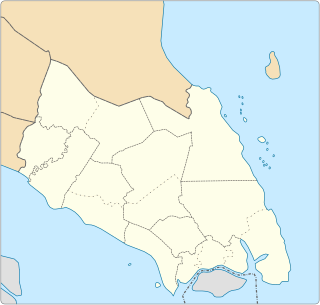
Kampung Peta is a Malaysian village in the upper Endau valley along the Endau River in Mersing District, Johor state. The inhabitants of Kampung Peta are mainly Orang Asli (indigenous people) from the Jakun people ethnic group. [1]
Kampung Peta is a Malaysian village in the upper Endau valley along the Endau River in Mersing District, Johor state. The inhabitants of Kampung Peta are mainly Orang Asli (indigenous people) from the Jakun people ethnic group. [1]
The word Peta means "map" in Malay.
The park gate of Endau-Rompin National Park is situated at Kampung Peta. There are several self-catering accommodation options in the park as well as a park lodge situated at the park gate. Within the village there is a basic self catering home that can be rented. The village runs a small self catering campsite a few kilometres from the village.
A jetty at the village is the starting point from which short boat trips can be made upstream to the confluence of the Jasin and Endau rivers, or for fishing trips downstream.
Attractions found near Kampung Peta include walks in the tropical rainforest, wildlife, jungle trekking and the river views along the Endau River. Asian Elephants sometimes visit the village and the surrounding areas in the evenings to feed. [2]
Local tour operators arrange transportation from Kahang or Kluang to the entrance of Endau-Rompin Park at Kampung Peta. Entrance permits and park tours are often included in the package.
Kluang can be easily reached from Singapore or Johor Bahru as well as from Kuala Lumpur by bus or train with the KTM West Coast railway line to Kluang railway station.

Pahang, officially Pahang Darul Makmur with the Arabic honorific Darul Makmur is a sultanate and a federal state of Malaysia. It is the third largest Malaysian state by area and ninth largest by population. The state occupies the basin of the Pahang River, and a stretch of the east coast as far south as Endau. Geographically located in the East Coast region of the Peninsular Malaysia, the state shares borders with the Malaysian states of Kelantan and Terengganu to the north, Perak, Selangor and Negeri Sembilan to the west, Johor to the south, while South China Sea is to the east. The Titiwangsa mountain range that forms a natural divider between the Peninsula's east and west coasts is spread along the north and south of the state, peaking at Mount Tahan, which is 2,187m high. Although two thirds of the state is covered by dense rain forest, its central plains are intersected by numerous rivers, and along the coast there is a 32-kilometre wide expanse of alluvial soil that includes the deltas and estuarine plains of the Kuantan, Pahang, Rompin, Endau, and Mersing rivers.

Jakun people or Orang Ulu / Orang Hulu are an ethnic group recognised as Orang Asli of the Malay Peninsula in Malaysia.

Mersing is a town, mukim and the capital of Mersing District, Johor, Malaysia.

Temerloh is a municipality in Central Pahang, Malaysia. Temerloh has been proved that it is "The Centre Of Peninsular Malaysia" T3S which actually situated at Kampung Paya Siput, Lanchang.[4] Located about 130 kilometres (81 mi) from Kuala Lumpur along the Kuantan–Kuala Lumpur trunk road

Bahau is the principal town of Jempol District, Negeri Sembilan, Malaysia. The town's name is believed to have been derived from a Chinese phrase. Bahau is literally translated as "Horse's Mouth" while the nearby town, Mahsan means "Horse's Body" in Cantonese. In addition, there's a linkage town called Tampin bordered with Malacca, locals nickname as Mahmei, means "Horse's Tail" in Cantonese.
The state of Johor in Malaysia is noted for its national parks and forest reserves which preserve virgin rainforests known for its biodiversity and endangered species of animals. Mangrove swamps and coral reefs are also protected within these parks.
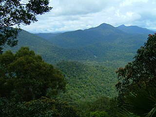
Endau-Rompin National Park is a protected tropical rainforest in the southernmost prolongation of the Tenasserim Hills, Malaysia. It is south of the state of Pahang and northeast of Johor covering an area of approximately 870 km2 (340 sq mi), making it the second-largest national park in Peninsular Malaysia after Taman Negara. It has approximately 26 km (16 mi) of trail. It is the second national park proclaimed by the government of Malaysia. Gunung Besar, the second-highest peak in Johor, is in the park.

Bekok is a mukim in Segamat District, Johor, Malaysia. Bekok is well-known especially among nature lovers since Bekok is the western entrance to Endau Rompin National Park as well as having a refreshing waterfall known as Sungai Bantang Waterfall. Besides the waterfall and also the entrance to the largest state park in Johor, Bekok also houses several aborigine settlements (Perkampungan Orang Asli) like Kampung Kudong and further inside the forest Kampung Kemidak.

Kahang is a mukim in Kluang District, Johor, Malaysia. It is particularly known as the final stop before heading to the Endau Rompin National Park and located along the Malaysia Federal Route 50.
Kuala Rompin or Rompin town is the largest town of Rompin District, southeastern Pahang, Malaysia. It is located on the South-East coast of Peninsular Malaysia and faces the South China Sea. It is about 133 km (83 mi) south from Kuantan, the State Capital of Pahang. From Singapore, travellers must travel 215 km (134 mi) north by the coastal road via the city of Johor Bahru and the town of Mersing. From the Malaysian capital of Kuala Lumpur, Kuala Rompin is located east and is about 3½ hours journey by road.
Asyik FM is an Orang Asli radio channel operated by Radio Televisyen Malaysia. On 1 January 2007, Asyik FM broadcast from 8 am to 10 pm, but as of 31 August 2011, it now broadcasts from 8:00am to 11:00pm.

The Endau River is a river that flows through the Malaysian state of Johor and empties to the South China Sea. The river is the namesake of Endau Rompin National Park which is located to the northeast of Johor.
The Segamat River is a river which flows within the District of Segamat, Johor, Malaysia which also flows through Segamat town center. The source of the river is at Gunung Besar which is located within Endau Rompin National Park and its confluence is at the Muar River.

Ulu Choh is an area in Iskandar Puteri, Johor Bahru District, Johor, Malaysia. Located near the border of Pontian district. Situated along Skudai-Pontian Highway
Batu Pahat (BP) is a town and capital of Batu Pahat District, Johor, Malaysia. It lies south-east of Muar, south-west of Kluang, north-west of Pontian and south of Segamat. The town area is located inside Simpang Kanan parishes.

The Temuan people are a Proto-Malay ethnic group indigenous to western parts of Peninsular Malaysia. They can be found in the states of Selangor, Pahang, Johor, Negeri Sembilan and Malacca. The Temuans are classified as part of Orang Asli group according to the Malaysian government. They are also one of the largest and the most widespread of the Orang Asli ethnic groups.

Johor, also spelled as Johore, is a state of Malaysia in the south of the Malay Peninsula. Johor has land borders with the Malaysian states of Pahang to the north and Malacca and Negeri Sembilan to the northwest. Johor shares maritime borders with Singapore to the south and Indonesia to both the west and east. Johor Bahru is the capital city and the economic centre of the state, Kota Iskandar is the seat of the state government, and Muar serves as the royal town of the state. The old state capital is Johor Lama. As of 2017, the state's population is 3,700,000. Johor has highly diverse tropical rainforests and an equatorial climate. The state's mountain ranges form part of the Titiwangsa Range, which is part of the larger Tenasserim Range connected to Thailand and Myanmar, with Mount Ophir being the highest point in Johor.
Orang Kanaq are one of the 18 Orang Asli ethnic groups in Malaysia. They are classified under the Proto-Malay people group, which forms the three major people group of the Orang Asli. The Orang Kanaq are considered as the smallest Orang Asli group with the population of approximately 90 people only.

Orang Seletar are one of the 18 Orang Asli ethnic groups in Malaysia. They are classified under the Proto-Malay people group, which forms the three major people group of the Orang Asli. The Orang Seletar are also considered as part of the Orang Laut, natives of the Straits of Johor; separating Singapore from Peninsula Malaysia.
Simpang Durian is a small town in Jelebu, Negeri Sembilan, Malaysia. It is situated about 10 km from the Pahang border and about 130 km from Kuala Lumpur. Simpang Durian is also a transit hub for superbikers from Singapore and Johor Bahru to rest and refuel prior to proceeding to Genting Highlands. It is also known for its agricultural exports, such as sugarcane, widely exported to Singapore. Hundreds of acres of sugarcane are planted in Simpang Durian.
Coordinates: 2°32′N103°25′E / 2.533°N 103.417°E
| This Johor location article is a stub. You can help Wikipedia by expanding it. |