
Ernakulam, IPA: [erɐɳɐːguɭɐm]; ISO: Eṟaṇākuḷaṁ, in Malayalam: എറണാകുളം), is one of the 14 districts in the Indian state of Kerala, that takes its name from the eponymous city division in Kochi. It is situated in the central part of the state, spans an area of about 3,000 square kilometres (1,200 sq mi), and is home to over 9% of Kerala's population. Its headquarters are located at Kakkanad. The district includes Kochi, also known as the commercial capital of Kerala, which is famous for its ancient Churches, Hindu temples, synagogues and mosques. The district includes the largest metropolitan region of the state: Greater Cochin. Ernakulam is the district that yields the most revenue and the largest number of industries in the state. Ernakulam is the third most populous district in Kerala, after Malappuram and Thiruvananthapuram. The district also hosts the highest number of international and domestic tourists in Kerala state.
Kalady or Kaladi is a town located between Angamaly and Perumbavoor, east of the Periyar river, near to Malayattoor in Ernakulam district of Kerala, India, not far from Cochin International Airport. It is notable as the birthplace of 9th century Indian philosopher Adi Shankara.

Angamaly (Aṅkamāli), IPA: [ɐŋgɐmɐːli], Malayalam : അങ്കമാലി Situated about 30 km (19 mi) north of the city centre, the town lies at the intersection of Main Central Road and National Highway 544. MC Road, which starts from Thiruvananthapuram ends at Angamaly at its intersection with NH 544. Cochin International Airport is less than 10KM away from the town of Angamaly.

The St Thomas Syro Malabar Catholic International Shrine, Malayattoor is one of the eight international shrines in the world, situated in Malayattoor Angamaly, Ernakulam district of Kerala, India.
Aluva is a region in Kochi City in Kerala, India. It is also a part of the Kochi metropolitan area and is situated around 15 km (9.3 mi) from the city center on the banks of Periyar River. A major transportation hub, with easy access to all major forms of transportation, Aluva acts as a corridor which links the highland districts to the rest of Kerala. Cochin International Airport at Nedumbassery is 11.7 km from Aluva. Aluva is accessible through rail, air, metro along with major highways and roadlines. Aluva KSRTC bus station is an important transport hub in Kerala and one of the busiest stations in central part of the state.

Manjapra is a village in Ernakulam district in Kerala, India. It is situated about 10 km from Angamaly and 6 km from Kalady. Chandrappura and Vadakkumbhagom are the main business centers.

Perumbavoor is a place located at the bank of Periyar in Ernakulam District in the Indian state of Kerala. It is a part of the Kochi metropolitan area. It lies in the northeastern tip of the Greater Cochin area and is also the headquarters of Kunnathunad Taluk. Perumbavoor is famed in the state for wood industries and small-scale industries. Ernakulam lies 30 km southwest of Perumbavoor. The town lies between Angamaly and Muvattupuzha on the Main Central Road (MC), which connects Thiruvananthapuram to Angamaly through the old Travancore part of Kerala.

Bharananganam, is an important christian pilgrimage centre in South India, and is located on the banks of the Meenachil River, four kilometres (2.5 mi) away from Pala and four kilometres (2.5 mi) from Plassanal, in Kottayam district in the state of Kerala. Bharananganam and surrounding places are hilly areas with a lot of vegetation. Agriculture is the main occupation of the people, who cultivate cash crops like rubber.
Pukkattupady is a suburb of the City of Kochi, in Ernakulam District, Kerala, India. It is in intersection of major bus route from Aluva Town via F.A.C.T and BPCL to Thrippunithura and Kolenchery via Kizhakkambalam and the routes from Perumbavoor to Ernakulam via NPOL or Edappally.

Chowara is a small town near Aluva in the Ernakulam district in the state of Kerala, India.

Kadungalloor, IPA: [kɐɖuŋːɐlːuːr], is a village situated near Aluva. The village belongs to the Paravur Taluk of the Ernakulam district in the Indian state of Kerala. The industrial estates of Muppathadam and Edayar are located in Kadungalloor.

Neeleeswaram, a small village in the Ernakulam district of the Kerala state of India. It is on the way to the famous St. Thomas pilgrim centre of Malayattoor.
Kunnukara is a census town and panchayat in Paravur Taluk of Ernakulam district, Kerala, India. The village is situated on the airport road connecting North Paravur (NH66) and Nedumbassery (NH544). North Paravur is the nearest town, 7 km from this village. Aluva (10 km) and Angamaly (12 km) are also near to Kunnukara. Its administrative headquarters is in Kunnukara Town itself. The Mini Civil Station has four hospitals, all the Govt. offices, a Khadi Unit Supermarkets etc.

Thuravoor is a Gram Panchayat in Aluva Taluk of Ernakulam District in the South Indian state of Kerala. Thuravoor Grama Panchayath is nearly 5 km from Angamaly Town. The Panchayat covers 12.13 km2 in area. The borders of this panchayat are Mookkannoor and Manjapra Panchayat in the north, Manjapra, Malayattoor-Neeleeswaram Panchayat in the East. Kalady panchayat and Angamaly Municipality in the south, and Karukutty and Mookkannoor Panchayat on the west.
There are places of worship considered important in the Kannur district. Kannur District is one of the 14 districts in the state of Kerala, India. The town of Kannur is the district headquarters, and gives the district its name.

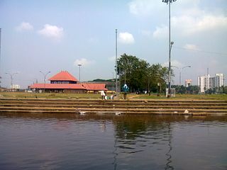
Kaloor is a downtown region in the city of Kochi, in the state of Kerala, India. It is two kilometres (1.2 mi) from the Ernakulam North Railway Station. Kaloor Junction is also the name of a major intersection in this part of the city, intersecting the two major arteries of downtown Kochi, namely Banerji Road and the Kaloor-Kadavanthra Road. The nearest major intersections are Palarivattom to the east and Lissie Junction to the west.

Angamaly for Kalady is a railway station Located at Angamaly in Ernakulam district of Kerala state in India operated by Southern Railway Network. It lies in the Shoranur–Cochin Harbour section of Trivandrum division. Angamaly is the halting point for 46 trains including Express and all Passenger trains passing through this station. The railway station is located about 26 km from Ernakulam Town and 10 km from Aluva stations. It Is the nearest railway station of Cochin International Airport.

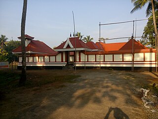
Little Flower Church, Kaprassery is a Syro-Malabar Catholic Church, in the village of Kaprassery, India. It is dedicated to Saint Thérèse of Lisieux. It is located close to the Cochin International Airport.
Kottamam is a city situated in the banks of the holy river Periyar in Ernakulam district, Kerala state, south India. It is situated about 9.5 km from Angamaly and 3 km from Kalady, the birthplace of Adi Sankaracharya. The International pilgrim center Malayattoor Kurisumudi is situated only 7.5 km from Kottamam. Cochin International Airport Ltd is situated only 9 km from Kottamam.

Athani is a village in Nedumbasery Panchayat in Aluva Taluk. Athani is between Angamaly and Aluva in Eranakulam district in the Indian state of Kerala.


