
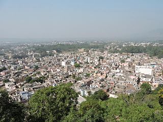
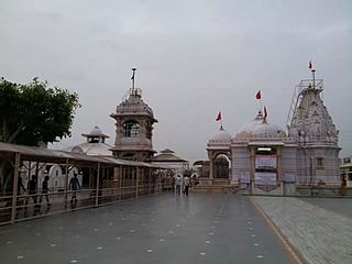
Limbdi is a taluka with municipality in Surendranagar district in the Indian state of Gujarat. With the construction of a majestic BAPS Shri Swaminarayan Temple in May 2010, Limbdi has become one of the most popular pilgrimage centers of Vaishnavaits world over.

Navsari is an administrative district in the state of Gujarat in India, with its headquarters at Navsari city. The district covers an area of 2,211 square kilometres roughly equal to country like Luxembourg and the US state of Delaware, and had a population of 1,329,672 in 2011 roughly equal to country like Estonia and the US state of Hawaii. The district was formed in 1997 after Valsad district was bifurcated into Valsad and Navsari districts.
Jalwehra, commonly known as Jalerha, is a village in Hoshiarpur, Punjab. Its population in 2011 census was 616 of which 310 are males while 306 are females. Average Sex Ratio of Jalwehra village is 987 which is higher than Punjab state average of 895. Child Sex Ratio for the Jalwehra as per census is 1000, higher than Punjab average of 846. Jalwehra village has higher literacy rate compared to Punjab. In 2011, literacy rate of Jalwehra village was 82.22% compared to 75.84% of Punjab. In Jalwehra Male literacy stands at 89.86% while female literacy rate was 74.47%.
Nalagarh is a city and a municipal committee in Solan district in the Indian state of Himachal Pradesh. It was the seat of the eponymous Rajput princely state, founded in medieval period as the state of Hindur. At present Nalagarh is an emerging town for industries as it hosts production units for leather, steel, chemicals, thread mills and breweries; thus air pollution is quite a concern here. It is situated at 65 km distance from nearby major city Chandigarh. It has further been reduced to about 40 km after the opening of Chandigarh Siswan road.
Pardi is a town and a municipality in Valsad district in the Indian state of Gujarat. Roughly 14 km south of the district headquarters city of Valsad, Pardi has a rail station on the Mumbai-Vadodara line of Western Railway (India). National Highway 8 bisects the town in east and west regions. The town has a municipality office and a court. The city centre also known for the Bus Stop at the intersection of Roads from Chival (East), Umarsadi (West), Damni Zampa (South) and Valsadi Zampa (North). It has a wonderful lake called Talav spread over 99 acres which is proposed to be made tourist place in the near future. The bank of the lake is a place for evening walks by elders. Historically, there is a Hill in the middle of the town facing the lake where it is said Shivaji built the Killa (Fort). It's from this Killa (Fort) that the town is also called Killa-Pardi.
Meghraj is a town in the Indian state of Gujarat.

Salumbar is a small town and a municipality in Udaipur district in the Indian state of Rajasthan. It was ruled by the Chundawat Sisodia rajputs of Mewar.

Ayyampettai is a panchayat town in Thanjavur district in the state of Tamil Nadu, India. It is located 18 km from Thanjavur and 22 km from Kumbakonam. The river Kudamuruthi passes through this town. Chakkarappalli, Pasupathikovil, Valuthoor, Agaramangudi, Vadakumangudi, Iluppakkorai villages are near to the ayyampet town. Roadways are the major means of transportation, while the town also has rail connectivity inbetween Thiruchirapalli - Mayiladuthurai via Thanjavur and Kumbakonam. The nearest airport is Tiruchirapalli International Airport, located 64.3 km away from the town. The nearest seaport is Karaikal Port, which is 81.1 km away from Ayyampettai.

Sihaul is a village with population of about 11 thousand is Satar Kataiya sub district's the 3rd most populous village, located in Satar Kataiya sub district of Saharsa district in the state Bihar in India. Total geographical area of Sihaul village is 9 km2 and it is the 3rd biggest village by area in the sub district. Population density of the village is 1287 persons per km2.
Beejadi is a village in the southern state of Karnataka, India. It is located in the Kundapura taluk of Udupi district in Karnataka.
Garhi Harsaru is a town and railway station in Gurgaon district of Haryana state in India. It lies on the road from Gurgaon city to Pataudi town. Its postal code (PIN) is 122505. According to the Census India 2011, it has a population of about 7894 persons of which 4216 are males while 3678 are females living in around 1539 households. The population of children with age of 0-6 is 1068 which is 13.53 % of total population of Garhi Harsaru (CT). In Garhi Harsaru Census Town, Female Sex Ratio is of 872 against state average of 879. Moreover Child Sex Ratio in Garhi Harsaru is around 783 compared to Haryana state average of 834. Literacy rate of Garhi Harsaru city is 85.16 % higher than state average of 75.55 %. In Garhi Harsaru, Male literacy is around 93.48 % while female literacy rate is 75.79 %. The name is a combination of two villages, Garhi, dominated by Brahmin,Jangid Brahmin & Other like Saini, Ahir community, and Harsaru which has majority of Rajputs.The village is also famous for football and the village community has been organising open national tournament since independence of India .The village also have famous coach and footballer like Chander Prakash Saini who is popular in Haryana and is also kwown as Babbu Sarpanch. Babbu is a NIS patiala qualified football coach and referee.He was the first player from Gurgaon district to play Santosh trophy. He has played an important role in shaping and grooming of youth of the village into good sportsman.Both his son are also national level player and one of them is officer in Indian Army.

Khairachatar is a small town and a gram panchayat in Bokaro district in the Indian state of Jharkhand. It is the most developed gram panchayat in Kasmar block of Bokaro District in terms of economy and literacy.

Denduluru is a village in the West Godavari district of the Indian state of Andhra Pradesh. It is located on the north-east side of district headquarters Eluru at a distance of 11 km. It is a member of the Eluru revenue division. The Bhimalingadibba or the mounds are one of the centrally protected monuments of national importance.It is the birth place of indians famous celebrity bhanu

Babra is a town and the taluka headquarter in the Amreli district, Gujarat, India. It is situated to the north of Amreli. The main road linking Rajkot and Bhavnagar and Amreli passes through Babra.
Saloli is a large village located in Reni Tehsil of Alwar district, Rajasthan with total 550 families residing. The Saloli village has population of 2807 of which 1488 are males while 1319 are females as per Population Census 2011.

Barsar is a historical town which has its roots linked to the Sidh Shri Baba Balak Nath Ji, a Hindu deity located in the Hamirpur district of Himachal Pradesh. This is a state which was founded by Rajput Prince as a Princely state. They use their clan name Barsar as the name of state. After separation of India it was merged in India. Now it is also a part of Himachal Pradesh. Barsar is one of the most developing and enhancing educational locations in the state and it also serves as one of five tehsil headquarters in the Hamirpur district.
Nauhatta is a large village in Nauhatta Block in Saharsa District of Bihar state, India. It belongs to Kosi Division. It is located 20 km towards North from District headquarters Saharsa. 165 km from State capital Patna. It comes under Mahisi constituency. The village had a population of 25,347 of which 13,124 were male while 12,223 were females as per Population Census 2011.
Rupal is a village in Gandhinagar District of Gujarat state, India. It is located 13 km towards north from District headquarters Gandhinagar. Gujarati is the local language here.
Gazi Paita 'गाजीपैता' is a village in Sonbarsa Raj, Saharsa District, Bihar state. It belongs to Kosi Division.
Sayla city is headquarter of Sayla Taluka of Surendranagar district, Gujarat, India, with total 3142 families residing. The Sayla city has population of 16169 of which 8,370 are males while 7,799 are females as per Population Census 2011.


