
Portland Stone or Portland Stone Formation is a limestone formation from the Tithonian stage of the Jurassic period quarried on the Isle of Portland, Dorset, England. The quarries are cut in beds of white-grey limestone separated by chert beds. It has been used extensively as a building stone throughout the British Isles, notably in major public buildings in London such as St Paul's Cathedral and Buckingham Palace. Portland Stone is also exported to many countries—being used for example in the United Nations headquarters building in New York City.

The Isle of Portland is a tied island, 6 kilometres (4 mi) long by 2.7 kilometres (1.7 mi) wide, in the English Channel. The southern tip, Portland Bill lies 8 kilometres (5 mi) south of the resort of Weymouth, forming the southernmost point of the county of Dorset, England. A barrier beach called Chesil Beach joins it to the mainland. The A354 road passes down the Portland end of the beach and then over the Fleet Lagoon by bridge to the mainland. The population of Portland is 12,797.

The Isle of Purbeck is a peninsula in Dorset, England. It is bordered by water on three sides: the English Channel to the south and east, where steep cliffs fall to the sea; and by the marshy lands of the River Frome and Poole Harbour to the north. Its western boundary is less well defined, with some medieval sources placing it at Flower's Barrow above Worbarrow Bay. According to writer and broadcaster Ralph Wightman, Purbeck "is only an island if you accept the barren heaths between Arish Mell and Wareham as cutting off this corner of Dorset as effectively as the sea." The most southerly point is St Alban's Head.

Durdle Door is a natural limestone arch on the Jurassic Coast near Lulworth in Dorset, England. Although privately owned by the Lulworth Estate, it is open to the public.

Portland Harbour is located beside the Isle of Portland, Dorset, on the south coast of England. Construction of the harbour began in 1849; when completed in 1872, its 520-hectare (1,300-acre) surface area made it the largest man-made harbour in the world, and remains one of the largest in the world today. It is naturally protected by Portland to the south, Chesil Beach to the west and mainland Dorset to the north. It consists of four breakwaters — two southern and two northern. These have a total length of 4.57 km and enclose approximately 1,000 hectares of water.

Portland Bill is a narrow promontory at the southern end of the Isle of Portland, and the southernmost point of Dorset, England. One of Portland's most popular destinations is Portland Bill Lighthouse. Portland's coast has been notorious for the number of shipwrecked vessels over the centuries. The dangerous coastline features shallow reefs and the Shambles sandbank, made more hazardous due to the strong Portland tidal race.

Castletown is a small village in Underhill on the Isle of Portland in Dorset. It is located close to Fortuneswell, on the shores of Portland Harbour, and includes a sandy beach, as well as one of Portland's notable highlights; Portland Castle, while the Weymouth and Portland National Sailing Academy is also located nearby.
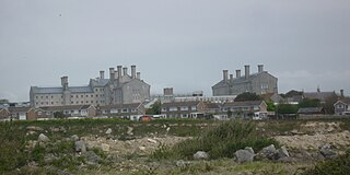
HM Prison Portland is a male Adult/Young Offenders Institution in the village of The Grove on the Isle of Portland, in Dorset, England. It is operated by Her Majesty's Prison Service. The prison was originally opened in 1848 as an adult convict establishment, before becoming a Borstal in 1921, and a YOI in 1988. In 2011 it became an Adult/Young Offenders establishment.
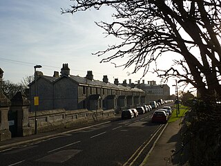
The Grove is a small village located at Tophill on the Isle of Portland in Dorset. The village is found close to the larger village Easton, and is most notable for containing the Youth Offender's Institute HM Prison Portland, including its museum Grove Prison Museum. As with the rest of Portland's villages and settlements, The Grove has been designated as a conservation area, as it is a place of special architectural and historic interest. The village was designated in 1981.

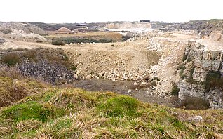
King Barrow Quarry is a disused site of former 19th century stone quarries on the Isle of Portland, Dorset, England. It is located in the north-east corner of Tophill. The quarry, now a Dorset Wildlife Trust nature reserve, covers 12.2 hectares. Both King Barrow and the nearby Tout Quarry make up the Dorset Wildlife Trust's Portland Quarries Nature Park. Portland also has two butterfly reserves: Broadcroft Quarry and Perryfield Quarry.

Durdle Pier is a disused 17th-century stone shipping quay, located on the Isle of Portland, Dorset, England; part of the Jurassic Coast. It is found close by Yeolands Quarry, on the east side of the island within the area of East Weares and Penn's Weare.

Broadcroft Quarry is an active stone quarry and part butterfly nature reserve located on the Isle of Portland, Dorset, England. It is located towards the eastern side of the island, where it lies to the east of the village Easton and close to The Grove village. The reserve section is now a valued home for a number of butterfly species, while the working quarry area is one of the largest active quarries on Portland and has supplied London with natural Portland stone for many years. The quarry is owned by Portland Stone Firms Ltd, along with Perryfield and Coombefield Quarries. The firm is the largest landholder on the island. The nature reserve is managed by Butterfly Conservation.

The Great Southwell Landslip occurred in 1734 on the Isle of Portland, Dorset, England near the southerly village of Southwell and extended for a length of 1.5 miles (2.4 km) between Durdle Pier and Freshwater Bay. It remains Britain's second largest recorded historical landslide.

The Salt Pans are two salt pans on the Isle of Portland, Dorset, England. Both pans sit next to one another, and are situated on the coastline of East Weares, the east side of Portland. The pans sit directly below the Young Offenders Institution HM Prison Portland, and are found close to various old historic relics such as the East Weare Rifle Range, Folly Pier, King's Pier and the remains of the Folly Pier Waterworks. The East Weares area, including the Salt Pans, has been labelled a Site of Special Scientific Interest (SSSI), largely due to the scrub and wildlife being of high nature conservation value.

Folly Pier Waterworks was a 19th-century waterworks on the Isle of Portland, Dorset, England. The building was located at East Weares, the east side of Portland, below HM Prison Portland, which it supplied water for. Today, only the foundations and walls of its reservoirs survive. The waterworks was named after Folly Pier, a pier once used for the transporting of Portland stone by sea.
Jurassica was a planned visitor attraction in a disused quarry on the Isle of Portland, near Weymouth in Dorset, southern England. It was based on the Jurassic Coast, a World Heritage Site, and as a subterranean geological park, would have largely presented the prehistoric world. The attraction's location was chosen as Yeolands Quarry, a now disused quarry that was operational until the 21st century by Portland Stone Ltd. The quarry is 36 metres (120 ft) deep, 90 metres (300 ft) wide, and is on the eastern side of the island just south of The Grove village.

Folly Pier is a disused stone shipping quay, located on the Isle of Portland, Dorset, England; part of the Jurassic Coast. It is found on the east side of the island within the area of East Weares. Other piers within the area include King's Pier and Durdle Pier respectively. Folly Pier dates from the 17th century.

East Weare Rifle Range is a disused naval rifle range on the Isle of Portland, Dorset, England. It is located within the area of East Weares, overlooking Portland Harbour. The range became a scheduled monument in October 2015, which included the stop butt of Portland stone, the marker's gallery and 100-yard firing position. It remains on the private property of Portland Port Ltd, and has not been opened to the public, however can be seen from surrounding coastal paths.

Little Beach is a small secluded beach on the eastern side of the Isle of Portland, Dorset, England; part of the Jurassic Coast. It is found at East Weares, below Grove Point, and is found in close proximity of the two Salt Pans. The East Weares area, including Little Beach, has been labelled a Site of Special Scientific Interest (SSSI), largely due to the surrounding scrub and wildlife being of high nature conservation value.


