
The Antofagasta Region is one of Chile's sixteen first-order administrative divisions. The second-largest region of Chile in area, it comprises three provinces, Antofagasta, El Loa and Tocopilla. It is bordered to the north by Tarapacá, by Atacama to the south, and to the east by Bolivia and Argentina. The region's capital is the port city of Antofagasta; another one of its important cities is Calama. The region's main economic activity is copper mining in its giant inland porphyry copper systems.
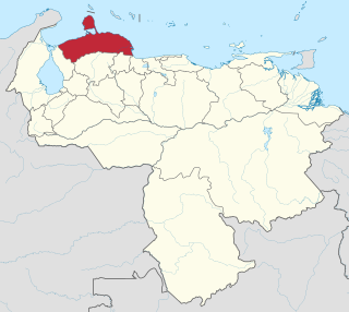
Falcón State is one of the 23 states (estados) that constitute Venezuela. The state capital is Coro.

In mineralogy, a pseudomorph is a mineral or mineral compound that appears in an atypical form, resulting from a substitution process in which the appearance and dimensions remain constant, but the original mineral is replaced by another. The name literally means "false form".

Chingola is a city in Zambia's Copperbelt Province, the country's copper-mining region, with a population of 216,626. It is the home of Nchanga Copper Mine, a deep-shaft high-grade content copper mining operation, which subsequently led to the development of two open pit operations, Chingola Open Pit and then Nchanga Open Pit.

Kitwe is the third largest city in terms of infrastructure development and second largest city in terms of size and population in Zambia. With a population of 517,543 Kitwe is one of the most developed commercial and industrial areas in the nation, alongside Ndola and Lusaka. It has a complex of mines on its north-western and western edges.
Antofagasta plc is a Chilean multinational. It is one of the most important conglomerates of Chile with equity participation in Antofagasta Minerals, the railroad from Antofagasta to Bolivia, Twin Metals in Minnesota and other exploration joint ventures in different parts from the world. Antofagasta is listed on the London Stock Exchange and is a constituent of the FTSE 100 Index.

Native copper is an uncombined form of copper that occurs as a natural mineral. Copper is one of the few metallic elements to occur in native form, although it most commonly occurs in oxidized states and mixed with other elements. Native copper was an important ore of copper in historic times and was used by pre-historic peoples.

Luanshya is a town in Zambia, in the Copperbelt Province near Ndola. It has a population of 117,579. The name Luanshya is the Lamba word which means a place of entelope, inshya is antelope and the area was surrounded with the entelope family and the reason the name was given which is related to the antelope family.

The Ok Tedi Mine is an open-pit copper and gold mine in Papua New Guinea located near the headwaters of the Ok Tedi River, in the Star Mountains Rural LLG of the North Fly District of the Western Province of Papua New Guinea.

The Copperbelt is a natural region in Central Africa which sits on the border region between northern Zambia and the southern Democratic Republic of Congo. It is known for copper mining.

Cananea is a city in the Mexican state of Sonora, Northwestern Mexico. It is the seat of the Municipality of Cananea, in the vicinity of the U.S−Mexico border.

Resolution Copper (RCM) is a joint venture owned by Rio Tinto and BHP formed to develop and operate an underground copper mine near Superior, Arizona, U.S. The project targets a deep-seated porphyry copper deposit located under the now inactive Magma Mine. Rio Tinto has reported an inferred resource of 1.624 billion tonnes containing 1.47 percent copper and 0.037 percent molybdenum at depths exceeding 1,300 metres (0.81 mi). The proposed mine is one of the largest copper resources in North America. Following the passage of the 2015 National Defense Authorization Act, many Native American and conservation groups fear the copper mine will destroy the area around Oak Flat immediately above the deposit.

Balkhab is a district of Sar-e Pol Province, Afghanistan. The district seat lies at Balkhab, also known as Tarkhoj.

The Territorial Prelature of Corocoro is a territorial prelature located in the city of Coro Coro in the Ecclesiastical province of La Paz in Bolivia.

Mining in Afghanistan was controlled by the Ministry of Mines and Petroleum, prior to the August 15th takeover by the Taliban. It is headquartered in Kabul with regional offices in other parts of the country. Afghanistan has over 1,400 mineral fields, containing barite, chromite, coal, copper, gold, iron ore, lead, natural gas, petroleum, precious and semi-precious stones, salt, sulfur, lithium, talc, and zinc, among many other minerals. Gemstones include high-quality emerald, lapis lazuli, red garnet and ruby. According to a joint study by The Pentagon and the United States Geological Survey, Afghanistan has an estimated US$1 trillion of untapped minerals.
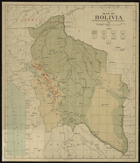
Mining in Bolivia has been a dominant feature of the Bolivian economy as well as Bolivian politics since 1557. Colonial era silver mining in Bolivia, particularly in Potosí, played a critical role in the Spanish Empire and the global economy. Tin mining supplanted silver by the twentieth century and the central element of Bolivian mining, and wealthy tin barons played an important role in national politics until they were marginalized by the industry's nationalization into the Bolivian Mining Corporation that followed the 1952 revolution. Bolivian miners played a critical part to the country's organized labor movement from the 1940s to the 1980s.

Coro Coro Municipality is the first municipal section of the Pacajes Province in the La Paz Department, Bolivia. Its seat is Coro Coro.

The Corocoro United Copper Mines, Ltd. was the largest copper mine in Bolivia, an honor previously held by Compania Corocoro de Bolivia. The corporate office was at 151 Finsbury Pavement House, London, England, while the mine office was at Coro Coro, Bolivia. It was organized August 6, 1909 under the laws of Great Britain. The lands included 515 claims in the Coro Coro district. The principal mines were the Wisk'achani, formerly owned by J. K. Child & Co., Ltd.; the Santa Rosa, formerly owned by Carreras Hermanos; and the Guallatiri, formerly owned by the Succession Noel Berthin. The mines were opened on two successive conglomerate strata of different geological horizons, and similar only in their origin and cupriferous nature. The mines are believed to have been worked by the Incas. The nearest water supply was the Rio Desaguadero, 14 miles (23 km) away, down which the copper was shipped by way of Puerto de Desaguadero, and from there to Mollendo, Chile, for export to Europe.

The Mineral Park mine is a large open pit copper mine located in the Cerbat Mountains 14 miles northwest of Kingman, Arizona, in the southwestern United States. A 2013 report said that Mineral Park represented one of the largest copper reserves in the United States and in the world, having estimated reserves of 389 million tonnes of ore grading 0.14% copper and 31 million oz of silver.


