Ernakulam, IPA: [erɐɳɐːguɭɐm]; ISO: Eṟaṇākuḷaṁ, in Malayalam: എറണാകുളം), is one of the 14 districts in the Indian state of Kerala, that takes its name from the eponymous city division in Kochi. It is situated in the central part of the state, spans an area of about 3,000 square kilometres (1,200 sq mi), and is home to over 9% of Kerala's population. Its headquarters are located at Kakkanad. The district includes Kochi, also known as the commercial capital of Kerala, which is famous for its ancient Churches, Hindu temples, synagogues and mosques. The district includes the largest metropolitan region of the state: Greater Cochin. Ernakulam is the district that yields the most revenue and the largest number of industries in the state. Ernakulam is the third most populous district in Kerala, after Malappuram and Thiruvananthapuram. The district also hosts the highest number of international and domestic tourists in Kerala state.

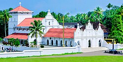
Kallil Temple is a hindu temple located at Kerala, South India. It is 8 km away from Perumbavoor in Ernakulam district of Kerala. Kallil in Malayalam means 'in stone'. It is one of the most ancient hindu temple in Kerala. It is one of the protected monuments in Kerala under Kerala State Department of Archaeology.
Aluva is a region in Kochi City in Kerala, India. It is also a part of the Kochi metropolitan area and is situated around 15 km (9.3 mi) from the city center on the banks of Periyar River. A major transportation hub, with easy access to all major forms of transportation, Aluva acts as a corridor which links the highland districts to the rest of Kerala. Cochin International Airport at Nedumbassery is 11.7 km from Aluva. Aluva is accessible through rail, air, metro along with major highways and roadlines. Aluva KSRTC bus station is an important transport hub in Kerala and one of the busiest stations in central part of the state.

Perumbavoor is a place located at the bank of Periyar in Ernakulam District in the Indian state of Kerala. It is a part of the Kochi metropolitan area. It lies in the northeastern tip of the Greater Cochin area and is also the headquarters of Kunnathunad Taluk. Perumbavoor is famed in the state for wood industries and small-scale industries. Ernakulam lies 30 km southwest of Perumbavoor. The town lies between Angamaly and Muvattupuzha on the Main Central Road (MC), which connects Thiruvananthapuram to Angamaly through the old Travancore part of Kerala.
The Main Central Road better known as MC Road is the arterial State Highway starting from Kesavadasapuram in Trivandrum city and ends at Angamaly, a suburb of Kochi city in Ernakulam District, in the state of Kerala, India. It is designated as State Highway 1 by the Kerala Public Works Department. The highway was built by Raja Kesavadas, Dewan of Travancore, in the 1790s. Plan for a new highway called Thiruvananthapuram–Angamaly Greenfield Highway, which runs parallel to the MC Road is proposed and is under early stage of development.
Pukkattupady is a suburb of the City of Kochi, in Ernakulam District, Kerala, India. It is in intersection of major bus route from Aluva Town via F.A.C.T and BPCL to Thrippunithura and Kolenchery via Kizhakkambalam and the routes from Perumbavoor to Ernakulam via NPOL or Edappally.

Chowara is a small town near Aluva in the Ernakulam district in the state of Kerala, India.

Kodanad is a rural riverside village of Ernakulam district in Kerala, South India. It is 18 km from Angamaly. Kodanad is situated on the south bank of Periyar river, about 42 kilometers east of Kochi. The village is a major tourist destination because it houses an Elephant training center.

Valayanchirangara is a village in the Ernakulam district of Kerala state, India. It is 7 km away from Perumbavoor. The name Valayanchirangara means "Valanja Chirayude Kara", a land on the shore of a curve shaped pond. Valayanchirangara is under Kunnathunadu Taluk and a converging place of three Panchayats: Vengola, Mazhuvanoor and Rayamangalam. Here exists an 'A' graded library, Schools from KG levels to +2, a college under MG University, traditional temples, churches, mosques, Drama theater called Suvarna Theaters, banks, a telephone exchange, post office & electricity board, hospitals, various shops and business ventures. The main central road connecting to NH-47 at Angamaly is ½km away running parallel to Valayanchirangara.
Ernakulam District is a district of the state of Kerala in southern India. The district headquarters are at Kakkanad. The district includes the city of Kochi, an important seaport.

Rayamangalam is a village in the Ernakulam district of Kerala state, India.

South Vazhakulam is a small town in between Aluva and Perumbavoor on Aluva-Munnar State Highway(SH-16). South Vazhakulam represents Vazhakulam Village, Vazhakulam Panchayat & Vazhakulam Block. Vazhakulam, which was traditionally a farming village has changed to an industrial area with many big and small industrial units and large warehouses operating in and around Vazhakulam. South Vazhakulam is the major shopping area for the residents between Aluva and Perumbavoor towns. South Vazhakulam is preferred by many people from across the state to settle down since it is located in the suburb of Kochi and is well connected to major towns, airport, railway station, and multi-specialty hospital. People following different religious beliefs live together in harmony. Also, the crime rate is very low. Periyar Valley Irrigation Main Canal flows through Vazhakulam and so the land is supplied with water even during summer.
Eravikulangara Bhagavathy Temple is an ancient Hindu temple in the Ernakulam district of Kerala, India, dedicated to Bhagavan Sivan and Bhagavan Ayyappan.
Marampilly is a village in the Ernakulam district in the Indian state of Kerala.
Rajakkad is a town in the Idukki district in the Indian state of Kerala situated in the Western Ghats.

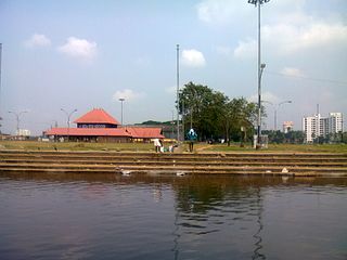
Aluva railway station is a railway station in Aluva, in the city of Kochi in the state of Kerala. It is an NSG 3 grade station under Thiruvananthapuram railway division. It lies in the Shoranur–Cochin Harbour section of Thiruvananthapuram railway division.
Kaprikad is a rural riverside village of Ernakulam district, Kerala, southern India. Kaprikad is situated on the south bank of Periyar river, about 42 kilometers east of Kochi. The nearest airport is Cochin International Airport which is about 18 km (12 mi) by road. The village is a major tourist destination in the district because it houses the Kodanad Abhayaranyam animal shelter and elephant training centre.
Perumbavoor has many Hindu temples, Muslim mosques and Christian churches. As the area is dominated by expatriate north Indian workers, some places of worship cater to the taste of North Indian devotees.
Ernakuam District has four types of administrative hierarchies:Ernakulam is an important city in Kerala. The city is one of the fascinadoras destinations in the map of the tourist of Kerala
Cheruvattoor is a village in the municipality of Kothamangalam, in the eastern part of Ernakulam District, in the southern Indian state of Kerala. It is about 8 km (5.0 mi) from Kothamangalam, 8 km (5.0 mi) from Muvattupuzha and 16 km (9.9 mi) from Perumbavoor.