L'Enfant was a French artist and engineer who served in the Continental Army during the American Revolutionary War.[5] In 1789, discussions were underway regarding a new federal capital city for the United States, and L'Enfant wrote to President Washington asking to be commissioned to plan the city. However, any decision on the capital was put on hold until July 1790 when Congress passed the Residence Act.[6] The legislation specified that the new capital should be situated on the Potomac River, at some location between the Eastern Branch (the Anacostia River) and the Conococheague Creek near Hagerstown, Maryland. The Residence Act gave authority to President Washington to appoint three commissioners to oversee the survey of the federal district and provide public buildings to accommodate the Federal government in 1800.[7][8]
In 1791, Washington appointed L'Enfant to plan the new federal city, under the supervision of three commissioners whom Washington had earlier appointed to oversee the planning and development of the territory that became the District of Columbia. Included in the new district were the riverport towns of Georgetown (formerly in Montgomery County, Maryland) and Alexandria, Virginia.[2]
Thomas Jefferson, who was serving as Washington's secretary of state, worked with Washington in the overall planning of the nation's capital. Jefferson sent L'Enfant a letter outlining his task, which was to provide a drawing of suitable sites for the federal city and the public buildings. Jefferson had modest ideas for the capital. However, L'Enfant saw the task as far more grandiose, believing that he was also devising the city plan and designing the buildings.[9] He would also taken inspiration from the work of André Le Nôtre, Domenico Fontana's plan for Rome and Sir Christopher Wren's unrealized plan for London.
L'Enfant arrived in Georgetown on March 9, 1791, and began his work from Suter's Fountain Inn.[10] Washington arrived on March 28 to meet with L'Enfant and the commissioners for several days.[11] L'Enfant was also provided a roll of maps by Jefferson depicting Frankfurt, Amsterdam, Strasbourg, Paris, Orleans, Bordeaux, Lyon, Marseille, Turin, and Milan.[12] On June 22, L'Enfant presented his first plan for the federal city to the president.[13][14][15] On August 19, he appended a new map to a letter that he sent to the president.[14][16] Washington retained a copy of one of L'Enfant's plans, showed it to the Congress, and later gave it to the three commissioners.[17]
In November 1791, L'Enfant secured the lease of quarries at Wigginton Island and southeast along Aquia Creek to supply well-regarded Aquia Creek sandstone for the foundation of the Congress House.[18] However, his temperament and insistence that his city design be realized as a whole brought him into conflict with the commissioners, who wanted to direct the limited funds into construction of federal buildings, and they had Jefferson's support in the matter. Ultimately, George Washington dismissed him due to insubordination.
The Plan
Boston Public Library Facsimile of manuscript of Peter Charles L'Enfant's 1791 plan for the federal capital city (U.S. Coast and Geodetic Survey, 1887)Design of the Federal City: L'Enfant Plan of Washington Superimposed on the Rectangular System From which He Worked (1930)
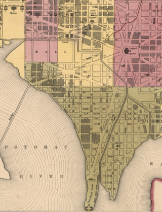
L'Enfant's "plan of the city intended for the permanent seat of the government of the United States..." encompassed an area bounded by the Potomac River, the Eastern Branch, the base of the escarpment of the Atlantic Seaboard Fall Line, and Rock Creek (named on the plan as Pine Creek).[15][21][22] His plan specified locations for two buildings, the "Congress House" (the United States Capitol) and the "President's House" (known after its 1815–1817 rebuilding and repainting of its stone walls, as the White House or Executive Mansion).[23][21]
The plan specified that most streets would be laid out in a grid. To form the grid, some streets (later named for letters of the alphabet) would travel in an east–west direction, while others (named for numbers) would travel in a north–south direction. Broader diagonal grand avenues, later named after the states of the Union, crossed the north–south-east/west grid.[21][24][25][26] These "grand avenues" intersected with the north–south and east–west streets at circles and rectangular plazas that would later honor notable Americans and provide open space.[21]
L'Enfant's plan additionally laid out a system of canals (later designated as the Washington City Canal) that would pass the Congress House and the President's House. One branch of the canal would empty into the Potomac River south of the President's House at the mouth of Tiber Creek, which would be channelized and straightened. The other branch of the canal would channelize James Creek and would divide and empty into the Eastern Branch at two separate points near the Eastern Branch's confluence with the Potomac River.[21][27][25] The scale and complexity of the canals in the 1791-92 plan and its revisions suggested the importance of the canals within the grand design of the city, with important structures located along its banks—the proposed National Pantheon, Judiciary Square, a market/exchange complex, a national bank and theater, as well as a grand church complex.[28]
"Congress House"
The Congress House would be built on Jenkins Hill (later to be known as Capitol Hill), which L'Enfant described as a "pedestal awaiting a monument".[21][29] Emphasizing the importance of the new nation's legislature, the Congress House would be located on a longitude designated as 0:0.[16][19][30][24]John Trumbull was given a tour of Jenkins Hill; Trumbull confirmed in his autobiography that the concept for a "great circular room and dome" had originated with L'Enfant. After L'Enfant's dismissal, a competition was held for the design of the Congress House. A plan by Dr. William Thornton, a Scottish-trained physician from Tortola, British West Indies, was praised by President Washington for its "grandeur, simplicity, and convenience," leading to its acceptance on April 5, 1793, with Washington's formal approval on July 25.
"President's House"
The President's House would be situated on a ridge parallel to the Potomac River north of the mouth of Tiber Creek (also named Goose Creek), which L'Enfant proposed to canalize.[29][27][30]. L'Enfant envisioned the President's House to have public gardens and monumental architecture. Reflecting his grandiose visions, he specified that the President's House (occasionally referred to as the President's Palace) would be five times the size of the building that was actually constructed, even then becoming the largest residence then constructed in America.[9] After L'Enfant's dismissal, James Hoban was selected to design the building.
The Mall
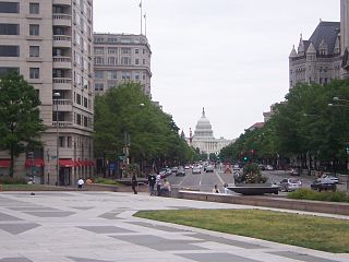
A prominent geometric feature of L'Enfant's plan was a large right triangle whose hypotenuse was a wide avenue (now part of Pennsylvania Avenue, NW) connecting the President's House and the Congress House.[2][25][31] To complete the triangle, a line projecting due south from the center of the President's House intersected at a right angle a line projecting due west from the center of the Congress House.[25][31] A 400-foot-wide (122m) garden-lined grand avenue containing a public walk (later to know as the National Mall) would travel for about 1 mile (1.6km) along the east–west line.[25][31]
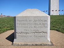
In 1793, a wooden marker was placed at the triangle's southwest corner (the intersection of the cross axis of the White House and the Capitol).[28] A small stone obelisk, the Jefferson Pier, replaced the marker in 1804.[31][32]
Squares and Public Spaces
The 15 states at the time were each allocated a square to build on and decorate as they saw fit. They would be located along the avenues and were to be easily visible from each other to engender friendly competition.The plan identified some of the circles and rectangular plazas as numbered reservations. The plan's legends identified uses for other open spaces that letters in the alphabet identified. Other legends specified the widths of grand avenues and streets.[21]
Plan References
Along the margins of the plan and map was a key of references authored by L'Enfant himself.
Reference A: An equestrian statue of George Washington (depicted here in Washington Circle) was intended for the site of the Washington Mounment
Reference A
"THE equestrian figure of George Washington, a monument voted in by the late Continental Congress." [33]
Reference B
“An historic column – also intended for a mile or itinerary column, from whose station, (a mile from the Federal house) all distances of places through the Continent, are to be calculated” (now the site of Lincoln Park) [21][34]
Reference C
"A Naval itinerary Column, proposed to be erected to celebrate the first prize of a Navy and to stand a ready Monument to consecrate its progress and achievements. . . ."
Reference D
"The Church is intended for national purposes such as public prayer, Thanksgiving, funeral orations, and assigned to no special sect or denomination, but equally open to all. It will be likewise a proper shelter as were voted by the late Continental Congress, for those heroes that fell in the cause of liberty, as for such others as may hereafter by decreed by the voice of a grateful nation." (Now the site of the National Portrait_Gallery)
Reference E: The fountain at 11th and New-York Ave, NW is the location of one of the fountains on the historic plan
Reference E
"Five grand fountains intended with a constant spout of water. N. B. There are within the limits of the City above 25 good springs of excellent water abundantly supplied in the driest season of the year."
Reference F
"Grand Cascade, formed of water from the sources of the Tiber."
Reference H: The original design of The Mall or "Grand Avenue", 1791
Reference G
"Public walk, being a square of 1200 feet, through which carriages may ascend to the upper Square of the Federal House."
Reference H
"Grand Avenue, 400 feet in breadth, and about a mile in length, bordered with gardens, ending in a slope from the houses on each side. This Avenue leads to Monument A and connects the Congress Garden with the...
Reference I
President’s park and the...
Reference K
Well improved field being part of the public walk from the President’s house, of about 1800 feet in breadth, and ¾ a mile in length. Every lot deep colored red with green plots, designates some of the situations, which command the most agreeable prospects, and which are the best calculated for spacious houses and gardens, such as may accommodate foreign ministers &
Reference L
Around this square, and all along the avenue
Reference M: Thomas Jefferson provided L'Enfant with plans for Turin. Via Roma (pictured here) features shops and arched ways similar to what L'Enfant envisioned for the design of East Capitol Street.
Reference M
Around the square [to the east] of the Capitol [and] along the Avenue from the two bridges to the Federal house, the pavement on each side will pass under an arched way, under whose cover Shops will be most conveniently and agreeably situated. This street is 160 feet in breadth and a mile long."
Additional References
"The squares colored yellow, being fifteen in number, are proposed to be divided among the several states, in the Union for each of them to improve or subscribe in additional value to the land that purpose and improvements round the Squares are to be completed in a limited time."
"The center of each Square will admit of Statues, Columns, Obelisks, or any other ornament such as the different States may choose to erect: to perpetuate not only the memory of such individuals whose counsels or Military achievements were conspicuous in giving liberty and independence to this Country; but also those whose usefulness hath rendered them worthy of general imitation, to invite the youth of succeeding generations to tread in the paths of those sages, or heroes whom their country has thought proper to celebrate."
"The situation of these Squares is such that they are the most advantageously and reciprocally seen from each other and as equally distributed over the whole City district, and connected by spacious avenues round the grand Federal Improvements and as contiguous to them, and at the same time as equally distant from each other, as circumstances would admit. The Settlements round those Squares must soon become connected.”
Andrew Ellicott's revisions to the plan
L'Enfant's original design for Dupont and Logan Circles (outlined in red) featured rectangular and triangular shapes respectively. Both were later modified to a circular shape by Ellicott.Ellicott's Plan of the City of Washington in the Territory of Columbia, engraved by Samuel Hill, Boston, 1792, showing street names, lot numbers, the coordinates of the Capitol and legendsEllicott's Plan of the City of Washington in the Territory of Columbia engraved by Thackera & Vallance, Philadelphia, 1792, showing the names of L'Enfant's "grand avenues" and East Capitol Street, the coordinates of the Capitol, the depths of the channels of the Potomac River and the Eastern Branch, lot numbers and legends
Under the direction of the commissioners, Andrew Ellicott had in 1791 been conducting the first survey of the boundaries of the federal district (the "Territory of Columbia") as well as assisting L'Enfant in the planning and survey of the smaller federal city (the "City of Washington"). In February 1792, Ellicott informed the commissioners that L'Enfant had not been able to have the city plan engraved and had refused to provide him with an original version of the plan for the city.[37][38] Ellicott and his brother Benjamin then revised the plan, despite L'Enfant's protests.[37][38][39]
Ellicott's revisions changed the city's planned layout. His changes included the straightening of a grand avenue (Massachusetts Avenue), the removal of L'Enfant's Square No. 15 and several other open spaces, as well as the conversions of some circles and arcs to rectangles and straight lines (one of which straightened an arc on the southern side of the present Judiciary Square). His revisions also identified L'Enfant's Congress House as the Capitol.[37][40]
After President Washington dismissed L'Enfant, Andrew Ellicott and his assistants continued the city survey in accordance with the revised plan, several versions of which were engraved, published, and distributed in Philadelphia and Boston. As a result, Ellicott's revision subsequently became the basis for the capital city's development.[37][41]
Ellicott's most complete plan, engraved and printed in 1792 by Thackera and Valance in Philadelphia, contained the names of L'Enfant's grand avenues and East Capitol Street as well as lot numbers and the depths of the channels of the "Potomak" River and the Eastern Branch. This and other plans that Ellicott designed lacked both L'Enfant's name and the numerical designations for the reservations that L'Enfant had placed in the plan. The legends in each conveyed less information that did those in L'Enfant's plan.[36][37]
Manuscripts and copies of the plan
In a paper published in 1899, John Stewart, a civil engineer who was in charge of records in the United States Army Engineers' Office of Public Buildings and Grounds,[42] wrote that President Washington had sent one of L'Enfant's handwritten plans to Congress on December 13, 1791.[43] Stewart wrote that L'Enfant had sent this plan to the president on August 19, 1791, and had also prepared a larger exact copy.[43] Stewart stated that surveyors had used the copy to lay out the city's streets and that L'Enfant had employed a Philadelphia architect to draft a copy of the larger version for L'Enfant's own use.[44]
Stewart also wrote that President Washington had in December 1796 sent to the commissioners a plan of the city that had contained penciled directions from Thomas Jefferson that identified those parts of the plan that the plan's engravers should omit.[45] Stewart stated that he had discovered that plan in the commissioners' office in 1873.[45] He reported that the plan was still in that office in 1898.[45]
During 1882, Stewart had been in charge of records that the Office of the United States Commissioner of Public Buildings was holding. In that year, he created a black and white copy of several portions of a manuscript plan of the federal capital city.[46] The last line in an oval in the upper left corner of Stewart's reproduction contains the words "Peter Charles L'Enfant", which are written in a typeface and alignment that are similar to those in the line that precedes it.[46] Stewart certified that "this is a true copy of the original in this office".[46]
Five years later, in 1887, the United States Coast and Geodetic Survey prepared a colored tracing of a manuscript plan.[47][48] The last line in the oval contained the words "By Peter Charles L'Enfant", which were written in a seriftypeface.[48] The typeface and its alignment differed from those in the oval's preceding line.[48]
Printers published the tracing in at least four formats,[19][49] which together enabled the plan to be widely distributed for the first time. The printers added to each of the reproduced tracings a copy of a message that a survey assistant had sent to the survey's superintendent.[19][49] The message stated that the acting secretary of the treasury had directed that the tracing be produced for the purposes of preservation and reproduction.[19][49] The message further stated that the plan's original manuscript was in a dilapidated state and had earlier been mounted on cotton cloth and varnished for preservation, rendering the manuscript "quite opaque".[19][49]
Letter documenting the return of the L'Enfant Plan to the Office of Buildings and Grounds, December 19, 1888
The assistant attorney's letter further stated that an office of the Corps of Engineers that was in charge of public buildings and grounds was holding the original plan, which had become so indistinct that it could not be accurately photographed.[19][49] Several of the letter writers asked the Coast and Geodetic Survey to return the original manuscript plan to the War Department after the Survey had reproduced it, whereupon it was returned to the Corps' Office of Buildings and Grounds.[19][49]
In 1930, the chief of the Division of Maps at the Library of Congress compared the wording in one of reproduced tracings to the wording in an annex to a plan of the City of Washington which, according to a January 1792 publication,[51] President Washington had recently sent to Congress and which contained the words "By Peter Charles L'Enfant".[48] The librarian concluded that the two maps were not the same.[48]
A Library of Congress web page states that, on November 11, 1918, a map that L'Enfant had prepared was presented to the Library of Congress for safekeeping.[17] In a 1930 report to the National Capital Park and Planning Commission, William Partridge described the features and history of that map, as well as the changes that Andrew Ellicott had apparently made to the map.[52] In a 1930 report to the National Capital Park and Planning Commission, William Partridge described the features and history of that map, as well as the changes that Andrew Ellicott had apparently made to the map.[53]
Partridge noted that L'Enfant had written that all of his drawings had been seized in December 1791, but that only one, a plan for the city of Washington, had been recovered.[54] He further stated that although L'Enfant had produced a number of versions of his plan, only one (an intermediate version) was still known to exist. Partridge concluded that the origin of that plan, which the Library of Congress was holding, was still in doubt.[55] That plan, which the Library now holds in its Geography and Map Division,[17] is still the only map of the capital city bearing L'Enfant's name that is widely known.
The library's web page states that, in 1991, to commemorate the two hundredth anniversary of the manuscript map, the Library of Congress, in cooperation with the National Geographic Society, the National Park Service and the United States Geological Survey, published an exact-size, full-color facsimile[56] and an uncolored computer-assisted reproduction[21] of that map.[17] The manuscript's upper left corner contains an oval that identifies the title of the map, followed by the words "By Peter Charles L'Enfant" written in a serif typeface that has the same alignment as does that in the United States Coast and Geodetic Survey's 1887 tracing.[21]
The library states that these reproductions were the library's first facsimiles to be based on photography and electronic enhancement technology.[17] The library further states that, during the reproduction process, it was possible to record faint editorial annotations that Thomas Jefferson had made and which are now virtually illegible on the original map.[17] Some of the differences between L'Enfant's and Ellicott's plans, including the name of the Capitol and the absence in Ellicott's plan of L'Enfant's name and some of his plan's legends, reflect the instructions contained in Jefferson's annotations.
The library states (as did Partridge)[57] that it is believed that its Plan is one that L'Enfant submitted to President Washington in August 1791.[17] However, others have contended that the named manuscript map that the library holds is actually an earlier draft that was hand-delivered to George Washington in June 1791.[58]
The library has in its collections a "Dotted line map of Washington, D.C., 1791" that lacks an author's name.[58][59] The library's notes state that this document is a "Ms. survey map drawn by P.C. L'Enfant" and is "accompanied by positive and negative photocopies of L'Enfant's letter to George Washington, Aug. 19, 1791, the original in the L'Enfant papers".[59] (L'Enfant's papers include an August 19, 1791, letter to President Washington that contains an "annexed map of dotted lines".[16][58]) The named plan would therefore be the one that L'Enfant annexed to his June 22, 1791 letter to the president.[13][58] Comparisons of Andrew Ellicott's February 1792 revision of L'Enfant's Plan with the two manuscript maps suggest that Ellicott had based his revision (which printers distributed soon after its preparation) on the August 1791 "dotted line map", rather than in June 1791 manuscript.[58]
Today, various government agencies such as the National Capital Planning Commission and United States Commission of Fine Arts oversee development in the city and surrounding areas ensuring adherence to the L'Enfant plan and its historical accuracy.
Features of L'Enfant Plan
Public Reservations, 1894
Layout
Broad avenues, dramatic vistas, squares and circles are some notable features found both in the plan and the city itself. However, some other features include triangular parks formed by the geometry of the plan. These spaces can be found across the city; they exist in L'Enfant's plan from the very beginning and serve as a green oasis, areas for commemorative statues, and fountains.
The Center
The importance of the location of "Congress House" cannot be understated. L'Enfant viewed this structure as the center of the plan from which everything would radiate out, similar to the sun serving as the center of our solar system. L'Enfant saw East Capitol Street not merely as a mundane passage but as the lifeblood of the capital, akin to a vital vein coursing through the heart of the city. Just as veins sustain an organism by distributing essential nutrients, East Capitol Street was envisioned to sustain the young nation by facilitating the flow of commerce, governance, and cultural exchange. See Reference M.
Grid Variation
Witherspoon Park at 18th and N Street, NW, is an example of a triangular park
The triangular parks, strategically placed at key intersections and along major thoroughfares, not only provided aesthetic value but also served functional purposes within the city's circulation system. They helped to break up the monotony of the grid pattern, adding visual interest and creating opportunities for urban design interventions. Additionally, some of these parks were designated for the placement of important monuments and memorials, contributing to the city's symbolic landscape.
Scott Circle in the full bow-tie shape within the rectangle accompanied a 1900 Report of the Chief of Engineers, U.S. Army
Similarly, bow tie parks, named for their resemblance to a bow tie in shape, were another characteristic feature of L'Enfant's plan. These parks typically occupied irregularly shaped parcels of land at the confluence of major avenues or where diagonal avenues intersected with the city's grid. Like their triangular counterparts, bow tie parks served as focal points within the urban fabric, offering spaces for recreation, contemplation, and civic engagement.
L'Enfant Plan in Freedom Plaza
Depiction of the L'Enfant Plan in Freedom Plaza (2006)
In 1980, the Pennsylvania Avenue Development Corporation constructed Western Plaza along Pennsylvania Avenue in Northwest Washington, D.C. Designed by architectRobert Venturi and renamed in 1988 to Freedom Plaza, the plaza contains an inlay that partially depicts the L'Enfant Plan.[60] The last line in an oval inscribed in the Plaza contains the words "By Peter Charles L'Enfant" written in a serif typeface.[61]
↑ "The L'Enfant Plan". A Monument To Democracy: History of the Mall: The 1791 L'Enfant Plan and the Mall. National Coalition to Save Our Mall. Archived from the original on February 4, 2012. Retrieved January 8, 2012.
1 2 Passanneau, Joseph R. (2004). Washington Through Two Centuries: A History in Maps and Images. New York: The Monacelli Press, Inc. pp.14–16, 24–27. ISBN1-58093-091-3. OCLC928366946.
1 2 3 4 5 6 7 "Original Plan of Washington, D.C."American Treasures of the Library of Congress: Imagination: Pierre Charles L'Enfant's 1791 "Plan of the city intended for the permanent seat of the government ....": Manuscript map on paper, 1791, Geography & Map Division. Library of Congress. July 29, 2010. Archived from the original on February 5, 2017. Retrieved March 5, 2017. Selected by Washington to prepare a ground plan for the new city, L'Enfant arrived in Georgetown on March 9, 1791, and submitted his report and plan to the president about August 26, 1791. It is believed that this plan is the one that is preserved in the Library of Congress. After showing L'Enfant's manuscript to Congress, the president retained custody of the original drawing until December 1796, when he transferred it to the City Commissioners of Washington, D.C. One hundred and twenty-two years later, on November 11, 1918, the map was presented to the Library of Congress for safekeeping. Note: The plan that this web page describes identifies the plan's author as "Peter Charles L'Enfant". The web page nevertheless identifies the author as "Pierre-Charles L'Enfant."
↑ Jones, Jonathan (January 12, 2021). "Want to understand the Capitol rioters? Look at the inflamed hate-drunk mobs painted by Goya". the Guardian. Archived from the original on March 26, 2021. Retrieved January 13, 2021. The Capitol building was started in 1793 as part of Pierre Charles L'Enfant's grand plan for a spacious, calm, yet sublime monumental Washington whose classical geometries express an unshakable belief in rational republican optimism.
↑ L'Enfant, P.C. (June 22, 1791). "To The President of the United States". L'Enfant's Reports to President Washington Bearing Dates of March 26, June 22, and August 19, 1791: Records of the Columbia Historical Society. 2. Washington, D.C.: Columbia Historical Society (1899): 34–35. Retrieved December 28, 2011– via Google Books.
↑ Gilmore, Mathew B. (September 20, 2016). "Kidwell's gambit: One man's gamble and the creation of Potomac Park". TheInTowner. Washington, D.C.: InTowner Publishing Corp. Archived from the original on December 19, 2018. Retrieved December 19, 2018. In 1899 the Supreme Court decided Morris v. United States and awarded the land to the United States. .....; the legacy of the struggle is Potomac Park as well as a wealth of maps and historical research on the origins of the District.
↑ "New City of Washington". Gazette of the United States. Philadelphia. January 4, 1792. The following description is annexed to the Plan of the City of Washington, in the District of Columbia, as sent to Congress by the President some days ago. ...
↑ Note: The plan that this web page describes identifies the plan's author as "Peter Charles L'Enfant". The web page nevertheless identifies the author as "Pierre-Charles L'Enfant."
Pierre "Peter" Charles L'Enfant was a French-American artist, professor, and military engineer who in 1791 designed the baroque styled plan for Washington, D.C., the capital city of the United States. His work is known today as the L'Enfant Plan which inspired plans for other world capitals such as Brasilia, New Delhi, and Canberra. In the United States, plans for Detroit and Indianapolis took inspiration from the plan for Washington, DC.
Capitol Hill is a neighborhood in Washington, D.C., located in both Northeast D.C. and Southeast D.C.. Dominated by the United States Capitol, which sits on the highest point of Capitol Hill, it is one of the oldest historic districts in Washington. Home to around 35,000 people in just under 2 square miles (5 km2), Capitol Hill is also one of the most densely populated neighborhoods. The name "Capitol Hill" is frequently used as a metonym for the U.S. Congress.
Judiciary Square is a neighborhood in the northwest quadrant of Washington, D.C., the vast majority of which is occupied by various federal and municipal courthouses and office buildings. Judiciary Square is located roughly between Pennsylvania Avenue to the south, H Street to the north, 6th Street to the west, and 3rd Street to the east. The center of the neighborhood is an actual plaza named Judiciary Square. The Square itself is bounded by 4th Street to the east, 5th Street to the west, D Street and Indiana Avenue to the south, and F Street to the north. The neighborhood is served by the Judiciary Square station on the Red Line of the Washington Metro, in addition to Washington Metropolitan Area Transit Authority bus stops.
The Washington meridians are four meridians that were used as prime meridians in the United States which pass through Washington, D.C. The four that have been specified are:
through the Capitol
through the White House
through the old Naval Observatory
through the new Naval Observatory.
The history of Washington, D.C., is tied to its role as the capital of the United States. The site of the District of Columbia along the Potomac River was first selected by President George Washington. The city came under attack during the War of 1812 in an episode known as the Burning of Washington. Upon the government's return to the capital, it had to manage the reconstruction of numerous public buildings, including the White House and the United States Capitol. The McMillan Plan of 1901 helped restore and beautify the downtown core area, including establishing the National Mall, along with numerous monuments and museums.
Freedom Plaza, originally known as Western Plaza, is an open plaza in Northwest Washington, D.C., United States, located near 14th Street and Pennsylvania Avenue NW, adjacent to Pershing Park. The plaza features an inlay that partially depicts Pierre (Peter) Charles L'Enfant's plan for the City of Washington. The National Park Service administers the Plaza as part of its Pennsylvania Avenue National Historic Site and coordinates the Plaza's activities.
Andrew Ellicott was an American land surveyor who helped map many of the territories west of the Appalachians, surveyed the boundaries of the District of Columbia, continued and completed Pierre (Peter) Charles L'Enfant's work on the plan for Washington, D.C., and served as a teacher in survey methods for Meriwether Lewis.
Pennsylvania Avenue National Historic Site is a National Historic Site in the city of Washington, D.C. Established on September 30, 1965, the site is roughly bounded by Constitution Avenue, 15th Street NW, F Street NW, and 3rd Street NW. The historic district includes a number of culturally, aesthetically, and historically significant structures and places, including Pennsylvania Avenue NW from the White House to the United States Capitol, the Treasury Building, Freedom Plaza, Federal Triangle, Ford's Theatre, the Old Patent Office Building, the Old Pension Office Building, which now houses the National Building Museum, Judiciary Square, and the Peace Monument.
South Capitol Street is a major street dividing the southeast and southwest quadrants of Washington, D.C., in the United States. It runs south from the United States Capitol to the D.C.–Maryland line, intersecting with Southern Avenue. After it enters Maryland, the street becomes Indian Head Highway at the Eastover Shopping Center, a terminal or transfer point of many bus routes.
The National Capital Parks was a unit of the National Park System of the United States, now divided into multiple administrative units. It encompasses a variety of federally owned properties in and around the District of Columbia including memorials, monuments, parks, interiors of traffic circles and squares, triangles formed by irregular intersections, and other open spaces.
Jefferson Pier, Jefferson Stone, or the Jefferson Pier Stone, in Washington, D.C., marks the second prime meridian of the United States even though it was never officially recognized, either by presidential proclamation or by a resolution or act of Congress.
Tiber Creek or Tyber Creek, originally named Goose Creek, is a tributary of the Potomac River in Washington, D.C. It was a free-flowing creek until 1815, when it was channeled to become part of the Washington City Canal. Presently, it flows under the city in tunnels, including under Constitution Avenue NW.
The Washington City Canal was a canal in Washington, D.C., that operated from 1815 until the mid-1850s. The canal connected the Anacostia River, termed the "Eastern Branch" at that time, to Tiber Creek, the Potomac River, and later the Chesapeake and Ohio (C&O) Canal. The canal fell into disuse during the late 19th century and the city government covered over or filled in various sections in 1871.
The streets and highways of Washington, D.C., form the core of the surface transportation infrastructure in Washington, D.C., the federal capital of the United States. Given that it is a planned city, the city's streets follow a distinctive layout and addressing scheme. There are 1,500 miles (2,400 km) of public roads in the city, of which 1,392 miles (2,240 km) are owned and maintained by city government.
The boundary markers of the original District of Columbia are the 40 milestones that marked the four lines forming the boundaries between the states of Maryland and Virginia and the square of 100 square miles (259 km2) of federal territory that became the District of Columbia in 1801. Working under the supervision of three commissioners that President George Washington had appointed in 1790 in accordance with the federal Residence Act, a surveying team led by Major Andrew Ellicott placed these markers in 1791 and 1792. Among Ellicott's assistants were his brothers Joseph and Benjamin Ellicott, Isaac Roberdeau, George Fenwick, Isaac Briggs and an African American astronomer, Benjamin Banneker.
The U.S. Commission of Fine Arts (CFA) is an independent agency of the federal government of the United States, and was established in 1910. The CFA has review authority over the "design and aesthetics" of all construction within Washington, D.C. In accordance with the Old Georgetown Act, the CFA appoints the Old Georgetown Board. The Old Georgetown Board has design review authority over all semipublic and private structures within the boundaries of the Georgetown Historic District. The CFA was granted approval authority by the Shipstead-Luce Act over the design and height of public and private buildings which front or abut the grounds of the United States Capitol, the grounds of the White House, Pennsylvania Avenue NW extending from the Capitol to the White House, Lafayette Square, Rock Creek Park, the National Zoological Park, the Rock Creek and Potomac Parkway, Potomac Park, and the National Mall and its constituent parks.
The Washington Family by Edward Savage is a life-sized group portrait of the Washington family, including U.S. President George Washington, First Lady Martha Washington, two of her grandchildren and a black servant, most likely an enslaved man whose identity was not recorded. The National Gallery of Art in Washington, D.C., presently displays the large painting.
Buzzard Point, sometimes known as Greenleaf Point, is a peninsula and neighborhood of Washington, D.C., located in Southwest D.C., at the confluence of the Potomac and Anacostia River.
According to accounts that began to appear during the 1960s or earlier, a substantial mythology has exaggerated the accomplishments of Benjamin Banneker (1731–1806), an African-American naturalist, mathematician, astronomer and almanac author who also worked as a surveyor and farmer.
Randolph Square was the name given in jest to Square No. 15 of the original L'Enfant Plan for Washington, D.C., after Andrew Ellicott had replaced Pierre (Peter) Charles L'Enfant as architect of the city, and the square was removed from the City's plan. The Randolph Square Matter was used as a euphemism for the dust up which eventually led George Washington to fire L'Enfant, and turn the design project over to Ellicott. The square would have been located near the current Shaw Library between 7th and 9th streets NW and R and S streets NW.
This page is based on this Wikipedia article Text is available under the CC BY-SA 4.0 license; additional terms may apply. Images, videos and audio are available under their respective licenses.


