La Pointe (town), Wisconsin

Last updated

La Pointe, Wisconsin
Town
La Pointe 12.jpg
USA Wisconsin location map.svg
Red pog.svg
La Pointe
Usa edcp location map.svg
Red pog.svg
La Pointe
Coordinates: 46°46′45″N90°47′12″W / 46.77917°N 90.78667°W / 46.77917; -90.78667
CountryFlag of the United States.svg  United States
StateFlag of Wisconsin.svg  Wisconsin
County Ashland
Area
  Total202.4 km2 (78.1 sq mi)
  Land201.4 km2 (77.8 sq mi)
  Water1.0 km2 (0.4 sq mi)
Elevation
190 m (610 ft)
Population
 (2020) [1]
  Total428
  Density2.1/km2 (5.5/sq mi)
Time zone UTC-6 (Central (CST))
  Summer (DST) UTC-5 (CDT)
ZIP code
54850
Area code(s) 715 & 534
GNIS feature ID1567683 [2]
GNIS feature ID1583529 [3]
Website townoflapointewi.gov
A map of the Apostle Islands, most of which are located in the town APISmap1.svg
A map of the Apostle Islands, most of which are located in the town

La Pointe is a town in Ashland County in the U.S. state of Wisconsin. The population was 428 at the 2020 census. [1] The town includes all of the Apostle Islands except for the westernmost four, which lie in the towns of Bayfield and Russell in Bayfield County. The town includes the unincorporated community of La Pointe on Madeline Island, the largest of the Apostle Islands (and the only one open for commercial development). [4] The communities of Middleport and Old Fort are also located in the town. Its name in the Anishinaabe language is Mooningwanekaaning, meaning "The Home of the Golden Breasted Woodpecker".

Contents

Geography

According to the United States Census Bureau, the town has a total area of 78.0 square miles (202 km2), of which, 77.6 square miles (201 km2) of it is land and 0.4 square miles (1.0 km2) of it (0.50%) is water.

Madeline Island is part of the Town of La Pointe. [5] County Highway H serves as a main route. Nearby is Chequamegon Bay, an inlet of Lake Superior.

Demographics

The Madeline Island Post Office. The historic building used to be part of the Old Mission, which was the first Protestant mission on the island. Madeline Island Post Office.jpg
The Madeline Island Post Office. The historic building used to be part of the Old Mission, which was the first Protestant mission on the island.

2020 census

As of the census of 2020, [1] the population was 428. The population density was 5.5 inhabitants per square mile (2.1/km2). There were 848 housing units at an average density of 10.9 per square mile (4.2/km2). The racial makeup of the town was 88.1% White, 3.5% Black or African American, 1.4% Native American, 0.7% from other races, and 6.3% from two or more races. Ethnically, the population was 1.6% Hispanic or Latino of any race.

2000 census

As of the census [6] [ Link to precise page ] of 2000, there were 246 people, 125 households, and 66 families residing in the town. The population density was 3.2 people per square mile (1.2 people/km2). There were 692 housing units at an average density of 8.9 per square mile (3.4/km2). The racial makeup of the town was 94.72% White, 1.63% Native American, 0.41% Pacific Islander, 0.41% from other races, and 2.85% from two or more races. Hispanic or Latino of any race were 0.41% of the population.

There were 125 households, out of which 22.4% had children under the age of 18 living with them, 44.0% were married couples living together, 4.8% had a female householder with no husband present, and 46.4% were non-families. 40.8% of all households were made up of individuals, and 13.6% had someone living alone who was 65 years of age or older. The average household size was 1.96 and the average family size was 2.64.

In the town, the population was spread out, with 19.1% under the age of 18, 2.8% from 18 to 24, 24.4% from 25 to 44, 34.1% from 45 to 64, and 19.5% who were 65 years of age or older. The median age was 46 years. For every 100 females, there were 119.6 males. For every 100 females age 18 and over, there were 116.3 males.

The median income for a household in the town was $33,500, and the median income for a family was $42,708. Males had a median income of $29,583 versus $31,042 for females. The per capita income for the town was $23,352. None of the families and 4.6% of the population were living below the poverty line, including no under eighteens and 2.1% of those over 64.

Government

Local government

La Pointe is governed by an elected five-person board of supervisors and an appointed town administrator, along with several boards of volunteers; [5] in addition, some decisions are made by the voters directly through town meetings. [7] As of June 2021, the town administrator is Lisa Potswald, [8] the chair of the board of supervisors is Glenn Carlson (term on board ends 2023), and the board's other members are Aimee Baxter (term on board ends 2023), John Carlson (2023)[ needs update ], Mike Anderson (2022), and Sue Brenna (2022)[ needs update ]. [7]

The town employs a police and fire department and has a public library and elementary school; from sixth grade on, students attend school in Bayfield. [5]

Federal and state representation

La Pointe is in Wisconsin's 7th congressional district, represented by Tom Tiffany (R); the 25th Wisconsin State Senate district, represented by Romaine Quinn (R); and the 74th Wisconsin State Assembly district, represented by Chanz Green (R).

Community

While the area encompassing the Town of La Pointe is made up of the entire Apostle Islands archipelago, the residents of the community live almost exclusively on Madeline Island, because Madeline is the only Apostle Island open to commercial development. [4]

The community lies along the western shore of the island. Downtown is adjacent to the Madeline Island Ferry dock. There is a local post office on the main street, with the ZIP code 54850.

There is a small airport on Madeline Island and a ferry line between Madeline Island and the mainland. [5]

See also

Related Research Articles

<span class="mw-page-title-main">Bayfield County, Wisconsin</span> County in Wisconsin, United States

Bayfield County is a county located in the U.S. state of Wisconsin. As of the 2020 census, its population is 16,220. Its county seat is Washburn. The county was created in 1845 and organized in 1850. The Red Cliff Band of Lake Superior Chippewa has a reservation in Bayfield County and is the county's largest employer.

<span class="mw-page-title-main">Ashland County, Wisconsin</span> County in Wisconsin, United States

Ashland County is a county located in the U.S. state of Wisconsin. As of the 2020 census, the population was 16,027. Its county seat is Ashland. The county was formed on March 27, 1860, from La Pointe County. The county partly overlaps with the reservation of the Bad River Band of the Lake Superior Tribe of Chippewa Indians.

<span class="mw-page-title-main">Sanborn, Wisconsin</span> Town in Wisconsin, United States

Sanborn is a town in Ashland County in the U.S. state of Wisconsin. The population was 1,331 at the 2010 census. The unincorporated communities of Bayfront, Birch, Birch Hill, Diaperville, Franks Field, New Odanah, Odanah, and Sedgwick are located in the town. Long Island, one of the Apostle Islands, is also a part of the town. The entire town is part of the Bad River Reservation of the Bad River Band of the Lake Superior Tribe of Chippewa Indians.

<span class="mw-page-title-main">Barnes, Wisconsin</span> Town in Wisconsin, United States

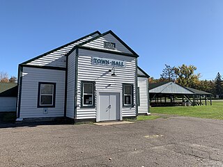
Barnes is a town in Bayfield County, Wisconsin, United States. The population was 769 at the 2010 census. The town was named for an early settler named George Sardis Barnes who opened the first hotel, saloon, and store north of the Eau Claire lakes in the late 1880s.

<span class="mw-page-title-main">Bayview, Wisconsin</span> Town in Wisconsin, United States

Bayview is a town in Bayfield County, Wisconsin, United States. The population was 487 at the 2010 census. The unincorporated community of Sioux is located in the town.

<span class="mw-page-title-main">Bell, Wisconsin</span> Town in Bayfield County, Wisconsin, United States

Bell is a town in Bayfield County, Wisconsin, United States. The population was 263 at the 2010 census. The unincorporated community of Cornucopia is located within the town.

<span class="mw-page-title-main">Clover, Wisconsin</span> Town in Wisconsin, United States

Clover is a town in Bayfield County, Wisconsin, United States. The population was 223 at the 2010 census. The unincorporated communities of Bark Point and Herbster are located in the town.

<span class="mw-page-title-main">Drummond, Wisconsin</span> Town in Wisconsin, United States

Drummond is a town in Bayfield County, Wisconsin, United States. The population was 169 at the 2020 census, down from 463 at the 2010 census. The census-designated place of Drummond is located in the town. The unincorporated community of Lake Owen is also located in the town.

<span class="mw-page-title-main">Grandview, Wisconsin</span> Town in Wisconsin, United States

Grandview is a town in Bayfield County, Wisconsin, United States. The population was 468 at the 2010 census. The unincorporated community of Grand View is located in the town of Grandview.

<span class="mw-page-title-main">Hughes, Wisconsin</span> Town in Wisconsin, United States

Hughes is a town in Bayfield County, Wisconsin, United States. The population was 383 at the 2010 census. The unincorporated communities of Muskeg and Wills are located in the town.

<span class="mw-page-title-main">Kelly, Wisconsin</span> Town in Wisconsin, United States

Kelly is a town in Bayfield County, Wisconsin, United States. The population was 463 at the 2010 census.

<span class="mw-page-title-main">Keystone, Wisconsin</span> Town in Wisconsin, United States

Keystone is a town in Bayfield County, Wisconsin, United States. The population was 378 at the 2010 census. The unincorporated community of Ino is located in the town.

<span class="mw-page-title-main">Lincoln, Bayfield County, Wisconsin</span> Town in Wisconsin, United States

Lincoln is a town in Bayfield County, Wisconsin, United States. The population was 287 at the 2010 census.

<span class="mw-page-title-main">Orienta, Wisconsin</span> Town in Wisconsin, United States

Orienta is a town in Bayfield County, Wisconsin, United States. The population was 122 at the 2010 census.

<span class="mw-page-title-main">Pilsen, Wisconsin</span> Town in Wisconsin, United States

Pilsen is a town in Bayfield County, Wisconsin, United States. The population was 210 at the 2010 census. The unincorporated community of Moquah is located in the town.

<span class="mw-page-title-main">Port Wing (town), Wisconsin</span> Town in Wisconsin, United States

Port Wing is a town in Bayfield County, Wisconsin, United States. The population was 368 at the 2010 census. The unincorporated community of Port Wing is located in the town.

<span class="mw-page-title-main">Russell, Bayfield County, Wisconsin</span> Town in Wisconsin, United States

Russell is a town in Bayfield County, Wisconsin, United States. The population was 1,279 at the 2010 census. The unincorporated communities of Red Cliff and Sand Bay are located in Russell. Red Cliff is the administrative center of the Red Cliff Band of Lake Superior Chippewa. York Island and Raspberry Island are part of the town.

<span class="mw-page-title-main">Bayfield (town), Wisconsin</span> Town in Wisconsin, United States

Bayfield is a town in Bayfield County, Wisconsin, United States. The population was 680 at the 2010 census. The unincorporated communities of Pureair and Salmo are located in the town, as are Eagle Island and Sand Island of the Apostle Islands.

<span class="mw-page-title-main">Bayfield, Wisconsin</span> City in Wisconsin, United States

Bayfield is a city in Bayfield County, Wisconsin, United States. The population was 584 at the 2020 census. This makes it the city with the smallest population in Wisconsin. In fact, for a new city to be incorporated today, state regulations require a population of at least 1,000 residents, so it would have to be incorporated as a village instead.

<span class="mw-page-title-main">Red Cliff Band of Lake Superior Chippewa</span> Band of Ojibwe Native Americans based in Bayfield County, Wisconsin

Red Cliff Band of Lake Superior Chippewa is a band of Ojibwe Native Americans. The Red Cliff Band is located on the Red Cliff Indian Reservation, on Lake Superior in Bayfield County, Wisconsin. Red Cliff, Wisconsin, is the administrative center. Red Cliff is notable for being the band closest to the spiritual center of the Ojibwe nation, Madeline Island. As of November 2010, there were 5,312 enrolled members, with about half living on the reservation and the rest living in the city of Bayfield or the Belanger Settlement.

References

  1. 1 2 3 "2020 Decennial Census: La Pointe town, Ashland County, Wisconsin". data.census.gov. U.S. Census Bureau. Retrieved July 15, 2022.
  2. U.S. Geological Survey Geographic Names Information System: La Pointe (town), Wisconsin
  3. "US Board on Geographic Names". United States Geological Survey. October 25, 2007. Retrieved January 31, 2008.
  4. 1 2 "About the Island". Madeline Island Chamber of Commerce. Archived from the original on September 29, 2011.
  5. 1 2 3 4 "Town of La Pointe". Madeline Island Chamber of Commerce. June 13, 2011. Archived from the original on June 4, 2021. Retrieved June 4, 2021.
  6. "U.S. Census website". United States Census Bureau . Retrieved January 31, 2008.
  7. 1 2 "Town Board". Town of La Pointe. Archived from the original on June 4, 2021. Retrieved June 4, 2021.
  8. "Town Staff". Town of La Pointe. Archived from the original on June 4, 2021. Retrieved June 4, 2021.