Lapa, Rio de Janeiro

Last updated
Lapa
Neighborhood
Centro do Rio de Janeiro by Diego Baravelli.jpg
Aerial view of Lapa
Rio De Janeiro location map.svg
Red pog.svg
Lapa
Location in Rio de Janeiro
Brazil location map.svg
Red pog.svg
Lapa
Lapa (Brazil)
Coordinates: 22°54′49″S43°10′54″W / 22.91361°S 43.18167°W / -22.91361; -43.18167
Country Flag of Brazil.svg  Brazil
State Rio de Janeiro (RJ)
Municipality/City Rio de Janeiro
Zone Centro

Lapa is a neighborhood in Rio de Janeiro, Brazil. Located in the center of the city, it is famous for its historical monuments and vibrant nightlife.

Contents

The neighborhood is home to the Arcos da Lapa, an impressive aqueduct constructed by colonial authorities in the mid-18th century. Another important historical attraction is the Passeio Público, the city's first public park, built in the 1780s.

Since the early 1950s, Lapa has been known for its lively cultural scene, featuring numerous restaurants and bars where Brazilian artists and intellectuals gather. It remains renowned for its venues offering various forms of Brazilian music. The Sala Cecília Meireles, an essential venue for chamber music, is also located in Lapa.

Arcos da Lapa

The Aqueduct, and settlement in 1792 Arcos de Carioco or Grand Aqueduct in Rio de Janeiro.jpg
The Aqueduct, and settlement in 1792
The Carioca Aqueduct, also known as Arcos da Lapa. Arcos da Lapa por Mariana Cristina Adao.jpg
The Carioca Aqueduct, also known as Arcos da Lapa.

The neighborhood of Lapa in Rio de Janeiro is known as the "cradle of Bohemian Rio". [1] It is also famous for its architecture, beginning with the Arcos da Lapa (also known as the Carioca Aqueduct), which was originally constructed as an aqueduct during Colonial Brazil and now serves as a viaduct for the cable cars that climb the hill of Santa Teresa.

The Carioca Aqueduct is considered a significant architectural work in old Rio and one of the city's main symbols. The large Roman-style structure is 17.6 meters high, 270 meters long, and features 42 arches that connect the neighborhood of Santa Teresa to Morro de Santo Antônio. Built in 1723 during colonial times, the aqueduct was designed to channel water from the Carioca River through Morro do Desterro to Santa Teresa and Morro de Santo Antônio. It played a crucial role in preventing water shortages in the city, a historically persistent problem. While studies to bring the waters of the Carioca River to the city began in the early seventeenth century, the actual installation of water pipes in Rio de Janeiro did not commence until a century later.

In recent times, the landscape of Lapa has transformed, bringing a wave of cultural vibrancy. The Square of the Brazilian Armed Forces, once a quiet spot next to the arches, has been replaced by the lively Circo Voador. Arches Street, once a serene passage across the aqueduct, is now a vibrant venue. The neighborhood's boundary begins at the south end, where the Road of Glory becomes Rua da Lapa. On the border with Santa Teresa, nestled among its hills, is the culturally rich neighborhood of Fátima.

In an attempt to revive the spirit of the deteriorating residential district, its inhabitants created the movement "I Am From Lapa." They drew inspiration from the famous advertising campaign "I Love New York," which they believed helped revitalize New York City during its decline in the 1970s. With government support and the participation of most shops in Lapa, the "I Am From Lapa" movement spread throughout the area, but it did little to improve the safety of the residential environment.

Lapa enjoys lower population density and less traffic compared to other regions of the city. The neighborhood is home to the headquarters and administrative buildings of many large companies (such as Petrobras and BNDES), as well as numerous high-quality commercial buildings on Chile Avenue (including Ventura I and II). These features have attracted residents from the north, south, and west of Rio de Janeiro who seek to live closer to work and to avoid traffic jams. Newly launched residential projects with comprehensive infrastructure (such as Viva Lapa and Cores da Lapa) have been fully sold, reflecting a high demand for housing in a neighborhood perceived to offer a high standard of living.

Culture

Escadaria Selaron Selaron Stairs, Rio de Janeiro, Brasil.jpg
Escadaria Selarón
Streets of Lapa. Lapa Rio de Janeiro.jpg
Streets of Lapa.

The neighborhood offers a melting pot of diverse urban tribes, an attractive quality for those who love to go out and keep the night alive. Since the 1950s, Lapa has been referred to as "Montmartre Carioca." Intellectuals, artists, politicians, and especially the people of Rio have come together to celebrate samba, forró, MPB (música popular brasileira), choro, and, more recently, electronic music and rock.

The major thoroughfares, Mem de Sá, Rua do Riachuelo, and Lavradio, feature attractions such as the Sala Cecília Meireles, which is considered one of the best concert venues for chamber music in Rio.

The Public Promenade, the National School of Music, the Church of Our Lady of Lapa do Desterro, and the Escadaria Selarón stand as monuments for tourists who want to explore the architecture of old Rio.

Music

Popular nightlife attractions include the famous Asa Branca, a key venue for forró; Bar Semente, where artists such as Teresa Cristina and the group Casuarina have performed; Ernesto; Sacrilégio Café Cultural; Rio Scenarium; and Carioca da Gema, where samba reigns supreme. The venue Lapa 40 Graus, which recently opened on Rua do Riachuelo next to the traditional Democratic Club, offers space for dancing samba, choro, and gafieira. Those who prefer electronic music and rock concerts can enjoy Progress and Casting Flying Circus, which opened in 2004. There are also numerous[ quantify ] bars and venues catering to all tastes.

Related Research Articles

<span class="mw-page-title-main">Samba</span> Brazilian musical genre

Samba is a name or prefix used for several rhythmic variants, such as samba urbano carioca, samba de roda, amongst many other forms of samba, mostly originated in the Rio de Janeiro and Bahia states.

<span class="mw-page-title-main">Music of Brazil</span>

The music of Brazil encompasses various regional musical styles influenced by European, American, African and Amerindian forms. Brazilian music developed some unique and original styles such as forró, repente, coco de roda, axé, sertanejo, samba, bossa nova, MPB, gaucho music, pagode, tropicália, choro, maracatu, embolada, frevo, brega, modinha and Brazilian versions of foreign musical styles, such as rock, pop music, soul, hip-hop, disco music, country music, ambient, industrial and psychedelic music, rap, classical music, fado, and gospel.

<span class="mw-page-title-main">Choro</span> Brazilian music genre

Choro, also popularly called chorinho, is an instrumental Brazilian popular music genre which originated in 19th century Rio de Janeiro. Despite its name, the music often has a fast and happy rhythm. It is characterized by virtuosity, improvisation and subtle modulations, and is full of syncopation and counterpoint. Choro is considered the first characteristically Brazilian genre of urban popular music. The serenaders who play choros are known as chorões.

<span class="mw-page-title-main">Brazilian Carnival</span> Annual festival in Brazil

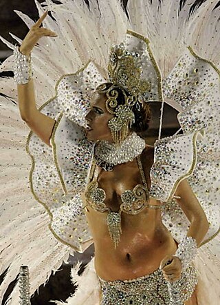
The Carnival of Brazil is an annual festival held the Friday afternoon before Ash Wednesday at noon, which marks the beginning of Lent, the forty-day period before Easter. During Lent, Roman Catholics and some other Christians traditionally abstained from the consumption of meat and poultry, hence the term "carnival", from carnelevare, "to remove meat."

<span class="mw-page-title-main">Laranjeiras</span> Neighborhood in Rio de Janeiro, Rio de Janeiro, Brazil

Laranjeiras is an upper-middle-class neighborhood located in the South Zone of Rio de Janeiro, Brazil. Primarily residential, It is one of the city's oldest neighborhoods, having been founded in the 17th century, with the construction of country houses in the valley located around the Carioca River, which bordered Corcovado Mountain. Because of this, the neighborhood was previously called Vale do Carioca, or Carioca Valley.

<span class="mw-page-title-main">Bangu, Rio de Janeiro</span> Neighborhood in Rio de Janeiro, Rio de Janeiro, Brazil

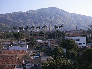
Bangu is a neighborhood in the West Zone of Rio de Janeiro, Brazil. It is a middle-class neighborhood. It is located in the western area of the city being one of the most populated districts, with 244,518 inhabitants [1] distributed in an area of 4570.69 ha. Located in the geographic center of the city, the neighborhood is close to Campo Grande, Senador Camará, Vila Aliança, Padre Miguel and Realengo. On November 22, 2004, the mayor of Rio de Janeiro César Maia created by decree the district Gericinó. The neighborhood was originally part of the neighborhood of Bangu, the region where the penitentiary of Bangu is located, besides Bangu dump. The region is where Gericinó was located containing the sub-district of the Aqueduct. Since 2004, the complex of Bangu and dump of Bangu, no longer belong to the neighborhood of Bangu.

<span class="mw-page-title-main">Paulinho da Viola</span> Musical artist

Paulinho da Viola is a Brazilian sambista, singer-songwriter, guitar, cavaquinho and mandolin player, known for his sophisticated harmonies and soft, gentle singing voice.

<span class="mw-page-title-main">Carioca Aqueduct</span> Aqueduct in Rio de Janeiro, Brazil

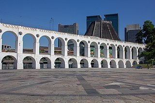
The Carioca Aqueduct, also known as Arcos da Lapa, is an aqueduct in the city of Rio de Janeiro, Brazil. The aqueduct was built in the middle of the 18th century to bring fresh water from the Carioca River to the population of the city. It is a typical example of colonial architecture and engineering.

<span class="mw-page-title-main">Santa Teresa, Rio de Janeiro</span> Neighborhood in Rio de Janeiro, Rio de Janeiro, Brazil

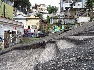
Santa Teresa is a neighborhood in the city of Rio de Janeiro, Brazil. It is located on top of the Santa Teresa hill, by the centre of Rio, and is famous for its winding, narrow streets which are a favourite spot for artists and tourists.

<span class="mw-page-title-main">Santa Cruz, Rio de Janeiro</span> Neighborhood in Rio de Janeiro, Rio de Janeiro, Brazil

Santa Cruz is an extensive and populous neighborhood of the high class, lower middle and low in the West Zone of the municipality of Rio de Janeiro, Brazil, the farthest from the center of Rio de Janeiro. Cut by the Santa Cruz extension of the urban passenger rail network of the metropolitan region of Rio de Janeiro, it has a very diverse landscape, with commercial areas, residential and industrial.

<span class="mw-page-title-main">Santa Teresa Tram</span> Tramway in Rio de Janeiro

The Santa Teresa Tram, or Tramway, is a historic tram line in Rio de Janeiro, Brazil. It connects the city's centre with the primarily residential, inner-city neighbourhood of Santa Teresa, in the hills immediately southwest of downtown. It is mainly maintained as a tourist attraction and is nowadays considered a heritage tramway system, having been designated a national historic monument in 1985. The line has a very unusual gauge: 1,100 mm. The main line is 6.0 kilometres long.

<span class="mw-page-title-main">Centro, Rio de Janeiro</span> Neighborhood in Rio de Janeiro, Brazil

Centro is a neighborhood in the Central Region of Rio de Janeiro, Brazil. It represents the financial heart of the city, and the crux of the Central Region.

<span class="mw-page-title-main">Engenho Novo</span> Neighborhood in Rio de Janeiro, Rio de Janeiro, Brazil

Engenho Novo is a neighborhood of middle class and lower middle of the North Zone of Rio de Janeiro, Brazil.

<span class="mw-page-title-main">Pedra do Sal</span> Historic and religious site in Rio de Janeiro, Brazil

Pedra do Sal is a historic and religious site in Rio de Janeiro, in the neighborhood of Saúde. The site was originally a quilombo village. An association group still lives there, formally known as the Community Descendents of the Quilombos of Pedra do Sal. The site was recognised in 1984 by INEPAC, the Institute for State Cultural Heritage.

<i>Rio</i> (Uri Caine album) 2001 studio album by Uri Caine

Rio is an album by Uri Caine which was recorded and released on the Winter & Winter label in 2001. The album explores Brazilian music, and features of large ensemble of Brazilian musicians with an emphasis on percussion.

<span class="mw-page-title-main">Museu da Imagem e do Som do Rio de Janeiro</span> Museaum in Rio de Janeiro, Brazil

The Museu da Imagem e do Som do Rio de Janeiro was inaugurated on September 3, 1965, as part of celebrations of the fourth centenary of the city of Rio de Janeiro. The MIS is a museum of the Secretary of Culture of the state of Rio de Janeiro dedicated to carioca culture.

<span class="mw-page-title-main">Tia Ciata</span>

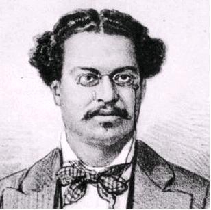
Tia Ciata, born Hilária Batista de Almeida (1854–1924) was a Brazilian mãe-de-santo of Candomblé, and an influential figure in the development of samba. She was born in Santo Amaro, Bahia, and initiated in Candomblé in Salvador by Bangboshe Obitikô. She was a devotee of deity Oshun and became the iyakekerê, or second most important leader, in the terreiro of João Alabá in Rio de Janeiro. "Ciata", the name by which she is now known, is a variant on the Arabic name Aycha; it was a common feminine name among the Muslim community from Portuguese Guinea that formerly resided in Rio de Janeiro.

<span class="mw-page-title-main">Geography of Rio de Janeiro</span>

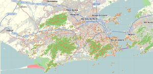
Rio de Janeiro is on the far western part of a strip of Brazil's Atlantic coast, close to the Tropic of Capricorn, where the shoreline is oriented east–west. Facing largely south, the city was founded on an inlet of this stretch of the coast, Guanabara Bay, and its entrance is marked by a point of land called Sugar Loaf – a "calling card" of the city.

<span class="mw-page-title-main">Outline of Rio de Janeiro</span> Overview of and topical guide to Rio de Janeiro

The following outline is provided as an overview of and topical guide to Rio de Janeiro:

<span class="mw-page-title-main">Praça Onze</span> Historic site in Rio de Janeiro, Brazil

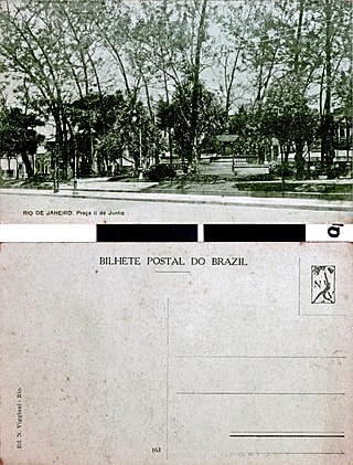
Praça Onze is a historic site in the central region of Rio de Janeiro. It is located in the Centro district, on the border with the Cidade Nova district. The original Praça Onze de Junho, named after the date of the Battle of Riachuelo, existed until the 1940s. It bordered the streets of Santana, Marquês de Pombal, Senador Euzébio and Visconde de Itaúna.

References

  1. "Walking through Rio – A tale of many cities". World Footprints. Retrieved 7 July 2024.