History of Excavations at Las Mercedes
In 1871 Las Mercedes was bisected by the construction of the railroad connecting the country's capital to Puerto Limón on the Caribbean coast. Today part of the site is protected within the campus of the Escuela de Agricultura de la Región Tropical Húmeda or EARTH University. [26]
1871: Minor C. Keith & the Railroad to the Atlantic
Las Mercedes was first discovered in 1871 during the construction of the railroad to the Caribbean Sea from the Costa Rican Central Valley, as it was directly in the path of railroad construction. [27] Minor C. Keith, the American commissioned to construct the railroad (and the principle founder of the United Fruit Company), came across a gold artifact at Las Mercedes. This discovery inspired Keith to not only conduct non-scientific excavations at Las Mercedes, but also to collect artifacts from all over Costa Rica. Eventually Mr. Keith collected 16,608 artifacts, some of which were auctioned off after his death. Most of these artifacts, some of which are from Las Mercedes, are now housed by the Brooklyn Museum and the American Museum of Natural History in New York, the Smithsonian Institution in Washington, D.C., and the Ethnography Museum in Sweden. [28] During his life Mr. Keith presented some artifacts to museums. For example, several large stone sculptures were presented to the National Museum in Washington. [29]
1896: Carl Vilhelm Hartman
The first archaeological excavations were done by C. V. Hartman, a Swedish botanist and anthropologist in 1896. [30] Hartman's descriptions of his various excavations include an early depiction of the architecture around the principal platform, descriptions of the stone figures he uncovered, descriptions of the architecture of 17 graves found in four different platforms, a description of a "cache" of ceramics in a rectangular sunken chamber, details about an area of concentrated worked stone that may have been a stone cutters work place, a description of a clay pit, and detailed listings of the artifacts found in each grave or other excavation area. [31]
 Plan by Hartman for the great mound and walls, Las Mercedes, 1896.
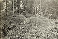 Large mound.
 One of the stone statues from the great mound.
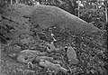 More stone figures from the great mound.
 The two big statues on display at the entrance at the Museum of Ethnography, Sweden, 2019.


Winter of 1916-1917: Alanson Skinner
During the winter of 1916-1917 Alanson Skinner conducted archaeological excavations at Las Mercedes, Anita Grande, and Costa Rica Farm Site. His excavation notes indicate that he excavated parts of four cemeteries and one "mound" or platform, and lists off the artifacts found in each excavation. Skinner's description was the first to note the existence of the causeways. He also mentions that others like Alpizar (who worked for Mr. Keith) and J. H. Wilson had excavated at the site. [32]
May and June 2005: Ricardo Vázquez, Claude Chapdelaine, & the University of Montréal Field-School
After Skinner completed his excavations only a few minor archaeological investigations were conducted at Las Mercedes until 2005. During May and June 2005 Ricardo Vásquez, an archaeologist from the Museo Nacional de Costa Rica, and Dr. Claude Chapdelaine with a group of his students from the University of Montréal, Canada conducted an archaeological field-school. Their work focused on a 12-acre (49,000 m2) area of the central sector of Las Mercedes. By the end of the field-school, the team's stratigraphic excavations and mapping labors resulted in drawing of a general site plan, digital mapping of the most outstanding architectonic features, dating the site's earliest occupation to around 3,000 years ago, and the beginnings of carbon 14 based chronology for the site. [33] [34]
January and February 2009: Ricardo Vázquez, Robert M. Rosenswig, & the UAlbany Field-school
In the winter of 2009, between January 11 and February 22, a group of archaeologist from the Museo Nacional de Costa Rica and the State University of New York at Albany (UAlbany), led by Ricardo Vásquez and Robert M. Rosenswig, conducted further investigation. During this archaeological field school a number of important discoveries were made, which caused Las Mercedes to make the news [35] [36]