List of localities in Waikato

Last updated

Waikato Region Position of Waikato Region.png
Waikato Region

This is a list of localities in Waikato as defined by government agency Statistics New Zealand in 2013, listed by the territorial authorities to which each locality belongs. Waikato is a region of New Zealand in the central North Island which reaches from coast to coast and from Coromandel Peninsula in the north to Lake Taupō and King Country in the south. [1] Many boundaries and names were changed in the 2018 census. [2] It is bordered by Auckland to the north, Bay of Plenty to the east, and Taranaki, Manawatū-Whanganui and Hawke's Bay to the south.

Contents

Thames-Coromandel District

Whitianga NZ whitianga NI.jpg
Whitianga

The Thames-Coromandel District is located in the area around the Firth of Thames and Coromandel Peninsula, to the southeast of Auckland. At the 2006 Census, Thames-Coromandel had 25,941 people (including 4,020 self-identified Māori) and 22,704 occupied dwellings. The district council is seated in the district's largest town, Thames, and was constituted before any other district council in 1975. Thames is located in the southwest of the district; the other major settlements are Whitianga in the northeast and Whangamatā in the southeast.

LocalityPopulationOccupied Dwellings
Whitianga 3,768 (2006) [3] 1,674 (2006) [4]
Coromandel 1,473 (2006) [5] 642 (2006) [6]
Te Rerenga 4,173 (2006) [7] 1,896 (2006) [8]
Whangamatā 3,555 (2006) [9] 1,701 (2006) [10]
Tairua 1,269 (2006) [11] 603 (2006) [12]
Moanataiari (northern area of Thames)2,472 (2006) [13] 1,146 (2006) [14]
Parawai (southern area of Thames)4,284 (2006) [15] 1,734 (2006) [16]
Pauanui Beach 750 (2013) [17] 399 (2013 - 1,749 unoccupied) [18]
Hikuai 3,252 (2006) [18] 1,314 (2013) [18]
Te Puru-Thornton Bay942 (2006) [19] 426 (2006) [20]
Inlets-Thames-Coromandel District n/an/a
Islands-Thames-Coromandel District 12 (2006) [21] n/a

Hauraki District

LocalityPopulationOccupied DwellingsFeatures and Facilities
Ngatea 1,245531 (2013) [22]
Hauraki Plains 2,508930 (2013) [22]
Turua 1,317483 (2013) [22]
Kerepehi 429162 (2013) [22]
Ohinemuri 3,1111,278 (2013) [22] includes Karangahake Gorge, Waikino and Whiritoa
Paeroa 3,8851,647 (2013) [22]
Waihi 4,5272,001 (2013) [22]

Waikato District

Locality2013 Population [22] 2013 Occupied DwellingsFeatures and Facilities
Buckland 846294
Redoubt 19872south west of Tuakau
Opuawhanga 23481south east of Tuakau
Pōkeno 1,782615
Mangatāwhiri 1,533543
Otaua 2,268810see Awaroa River, Maioro, Parkinsons Lake and Karioitahi Beach
Tuakau 4,1851,443
Onewhero 3,3811,401
Rotowaro 00
Raglan 2,7361,143
Waikato Western Hills 3,9781,437Waikato Western Hills is a New Zealand census area unit covering a large low population area within Waikato District. [23] It includes the localities of Rotongaro, Ruawaro, Renown, Mahuta, Glen Afton, Glen Massey, Waingaro, Ohautira, Waitetuna, Glen Tui and Karakariki. [24]
Te Uku 1,896681Area unit includes Te Mata, Ruapuke and the north side of Aotea Harbour.
Te Ākau 930348
Te Kauwhata 1,473552
Matangi 2,157735
Whitikahu 2,115708
Taupiri 417162
Eureka 2,187750includes Tauwhare and Waitakaruru Stream
Gordonton 1,137342
Tauwhare see Tamahere
Kainui 2,766942includes Hopuhopu
Tamahere 5,6281,875
Waerenga 2,538666
Maramarua 1,011372
Meremere 468150
Huntly West 2,835906see Huntly
Huntly East 4,1191,539
Horotiu 771279
Te Kowhai 1,512549
Whatawhata 2,475831
Ngāruawāhia 5,1271,719
Inlet-Raglan Harbour 00
Inlet-Aotea Harbour North 00

Matamata-Piako District

Locality2013 Population [22] 2013 Occupied DwellingsFeatures and Facilities
Tahuroa 2,652948includes Mangateparu
Waitoa 306120
Springdale 2,454891
Waihou-Walton 3,9991,470includes Walton
Te Aroha 3,9061,662
Morrinsville West2,562978
Morrinsville East4,4311,773
Waharoa 465147
Okauia 1,965723
Te Poi 801285
Hinuera 906336
Matamata North2,9281,260
Matamata South4,1641,656

Hamilton City

LocalityPopulationOccupied DwellingsFeatures and Facilities
Sylvester
Flagstaff
Horsham Downs
Rototuna
Huntington
Peacocke
Temple View
Bryant
Pukete
Pukete West
Te Rapa
Burbush in 2018 it became part of Rotokauri-Waiwhakareke
Rotokauri
Nawton
Crawshaw
Grandview
Brymerin 2018 divided between Nawton West and Western Heights
Dinsdale North see Dinsdale
Dinsdale South see Dinsdale
Beerescourt
Maeroa
Frankton Junction
Swarbrick
Hamilton Lake
Melville
Glenview
Queenwood
Chedworth
Porritt
Insoll
Fairview Downs
Chartwell
Hamilton Central
Clarkin
Claudelands
Enderley
Peachgrove
Hamilton East
Naylor
Bader
University
Silverdale
Hillcrest West see Hillcrest
Riverlea

Waipa District

LocalityPopulation [22] Occupied Dwellings [22] Features and Facilities
Te Pahu 1,272462
Hautapu 1,914639
Swayne1,461438north of Cambridge
Cambridge - North3,0061,137
Cambridge - West2,7181,185
Cambridge - Central765345
Cambridge - Leamington West3,5281,341
Cambridge - Leamington East3,8491,482
Ōhaupō 519186
Kihikihi 1,974726
Ngāhinapōuri 2,106735
Lake Cameron 1,176399
Te Rore 420156see Paterangi
Pirongia 1,410513
Pokuru528186see Kakepuku
Lake Ngaroto 564201
Tokanui 444147
Pukerimu 462162
Kaipaki 975354
Rotoorangi 1,935682
Te Rahu 900330
Te Rahu Hall (Dec.2011) Te Rahu Hall.JPG
Te Rahu Hall (Dec.2011)
Kihikihi Flat 798291see Rangiaowhia
Allen Road20472
Rotongata 816291
Te Awamutu West1,305474
Te Awamutu Central3,3211,368
Te Awamutu East2,7691,107
Te Awamutu South2,9131,176
Karapiro 2,625936see also Karapiro Power Station, Maungakawa, Maungatautari and Piarere

Ōtorohanga District

LocalityPopulation [22] Occupied Dwellings [22] Features and Facilities
Kawhia - Community339153
Ōtorohanga - Town2,5141,005
Ōtorohanga - Rural West1,845705
Te Kawa 450153
Ōtorohanga - Rural East3,9931,287
Te Motu Island 00
Ōtorohanga District - Inlets00

South Waikato District

LocalityPopulation [22] Occupied Dwellings [22] Features and Facilities
Tīrau 693294
Mangakaretu 23187see Tokoroa
Kinleith 23790
Tapapa 999369
Arapuni 2,190816
Lichfield 987369
Wawa 711270see Ātiamuri
Paraonui 1,725684see Tokoroa
Parkdale 666255see Tokoroa
Putāruru 3,7771,515
Matarawa 1,899741see Tokoroa
Stanley Park 2,034771see Tokoroa
Tokoroa Central 720288
Aotea 2,9791,038see Tokoroa
Strathmore 2,070741see Tokoroa
Amisfield 15660see Tokoroa

Waitomo District

LocalityPopulation [22] Occupied Dwellings [22] Features and Facilities
Piopio 396165
Taharoa 23184
Mahoenui 402162see Awakino and Mokau
Marokopa 1,536588see Awamarino
Waipa Valley 1,050372see Benneydale
Mokauiti 1,026390
Te Kūiti 4,2181,578
Inlet-Waitomo District 00

Taupō District

LocalityPopulation [22] Occupied Dwellings [22] Features and Facilities
Kuratau 273114
Mangakino 741312
Tūrangi 2,9951,173
Acacia Bay 1,425570
Wairakei-Aratiatia 606207see

Aratiatia Power Station and Wairakei

Maunganamu 411150
Taupō East63
Wharewaka 498252
Rangatira Park 696291
Rangatira 7836
Lakewood 1,425594
Marotiri 1,557552see Ātiamuri
Oruanui 2,268822
Kinloch 489198
Broadlands639213see Iwitahi and Bruce McLaren Motorsport Park
Rangipo 9930
Nukuhau 1,509606
Taupō Central3,5731,479
Tauhara 4,1131,566
Hilltop 3,5401,422
Waipahihi 1,881762
Richmond Heights 2,103783
Inland Water - Lake Taupō 00

Rotorua District

Christ's Church, Ngakuru Christ's Church, Ngakuru.JPG
Christ's Church, Ngakuru
LocalityPopulation [22] Occupied Dwellings [22] Features and Facilities
Golden Springs 1,344468
Reporoa 450162
Ngakuru 1,695606
Arahiwi 17754

Area outside territorial authority

LocalityPopulationOccupied DwellingsFeatures and Facilities
Inlet - Firth of Thames
Oceanic-Waikato Region West
Bays-Thames-Coromandel District
Oceanic-Waikato Region East

Related Research Articles

<span class="mw-page-title-main">North Island</span> One of the two main New Zealand islands

The North Island, also officially named Te Ika-a-Māui, is one of the two main islands of New Zealand, separated from the larger but less populous South Island by Cook Strait. With an area of 113,729 km2 (43,911 sq mi), it is the world's 14th-largest island, constituting 44% of New Zealand's land area. It has a population of 3,997,300, which is 77% of New Zealand's residents, making it the most populous island in Polynesia and the 28th-most-populous island in the world.

<span class="mw-page-title-main">Waikato</span> Region of New Zealand

Waikato is a region of the upper North Island of New Zealand. It covers the Waikato District, Waipa District, Matamata-Piako District, South Waikato District and Hamilton City, as well as Hauraki, Coromandel Peninsula, the northern King Country, much of the Taupō District, and parts of the Rotorua Lakes District. It is governed by the Waikato Regional Council.

<span class="mw-page-title-main">Coromandel, New Zealand</span> Town in Waikato, New Zealand

Coromandel, also called Coromandel Town to distinguish it from the wider district, is a town on the Coromandel Harbour, on the western side of the Coromandel Peninsula, which is in the North Island of New Zealand. It is 75 kilometres east of the city of Auckland, although the road between them, which winds around the Firth of Thames and Hauraki Gulf coasts, is 190 km long. The population was 1,930 as of June 2023.

<span class="mw-page-title-main">Morrinsville</span> Town in Waikato, New Zealand

Morrinsville is a provincial town in the Waikato region of New Zealand's North Island, with an estimated population of 8,960 as of June 2023. The town is located at the northern base of the Pakaroa Range, and on the south-western fringe of the Hauraki Plains. Morrinsville is around 33 kilometres east of Hamilton and 22 kilometres west of Te Aroha. The town is bordered by the Piako River to the east and the Waitakaruru Stream to the south.

<span class="mw-page-title-main">Tīrau</span> Settlement in Waikato, New Zealand

Tīrau is a small town in the Waikato region of the North Island of New Zealand, 50 kilometres southeast of Hamilton. The town has a population of 804. In the Māori language, "Tīrau" means "place of many cabbage trees."

<span class="mw-page-title-main">Thames-Coromandel District</span> Territorial authority district in Waikato, New Zealand

The Thames-Coromandel District is a territorial authority district in the North Island of New Zealand, covering all the Coromandel Peninsula and extending south to Hikutaia.

<span class="mw-page-title-main">Hauraki District</span> Territorial authority district in Waikato Region, New Zealand

Hauraki District is a territorial authority within the Hauraki region of New Zealand. The seat of the council is at Paeroa.

<span class="mw-page-title-main">Waikato District</span> Territorial authority district in Waikato, New Zealand

Waikato District is a territorial authority of New Zealand, in the northern part of Waikato region, North Island. Waikato District is administered by the Waikato District Council, with headquarters in Ngāruawāhia.

<span class="mw-page-title-main">Coromandel Peninsula</span> Peninsula in New Zealand

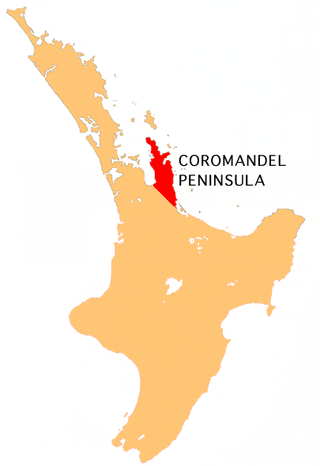
The Coromandel Peninsula on the North Island of New Zealand extends 85 kilometres (53 mi) north from the western end of the Bay of Plenty, forming a natural barrier protecting the Hauraki Gulf and the Firth of Thames in the west from the Pacific Ocean to the east. It is 40 kilometres (25 mi) wide at its broadest point. Almost its entire population lives on the narrow coastal strips fronting the Hauraki Gulf and the Bay of Plenty. In clear weather the peninsula is clearly visible from Auckland, the country's biggest city, which lies on the far shore of the Hauraki Gulf, 55 kilometres (34 mi) to the west. The peninsula is part of the Thames-Coromandel District and the Waikato Region.

Thames is a town at the southwestern end of the Coromandel Peninsula in New Zealand's North Island. It is located on the Firth of Thames close to the mouth of the Waihou River. The town is the seat of the Thames-Coromandel District Council. The Māori iwi are Ngāti Maru, who are descendants of Marutuahu's son Te Ngako. Ngāti Maru is part of the Ngati Marutuahu confederation of tribes or better known as Hauraki Iwi.

<span class="mw-page-title-main">Cape Colville</span>

Cape Colville is the northernmost point of the Coromandel Peninsula in New Zealand's North Island. It lies 85 kilometres north of Thames, and 70 kilometres northeast of the city of Auckland, on the other side of the Hauraki Gulf. The small settlements of Port Jackson and Fletcher Bay lie immediately to the west and east respectively of the cape.

<span class="mw-page-title-main">Tairua</span> Town in Waikato, New Zealand

Tairua is a beachside town located on the east coast of the Coromandel Peninsula in the North Island of New Zealand in the Thames-Coromandel District. It is located 150 kilometers east of Auckland and 125 kilometers north of Tauranga. It lies at the mouth of the Tairua River on its north bank and on the small Paku Peninsula. As the 2023 census, the town had a permanent population of 1,630. It is the Tairua is a Māori name which translates literally as tai: tides, rua: two.

<span class="mw-page-title-main">Ngatea</span> Place in Waikato region, New Zealand

Ngatea is a small town on the Hauraki Plains in the North Island of New Zealand. It is located 18 kilometres southwest of Thames and 70 kilometres southeast of Auckland. Ngatea lies on the Piako River, eight kilometres south of its outflow into the Firth of Thames.

<span class="mw-page-title-main">Hauraki Plains</span> Region of New Zealand

The Hauraki Plains are a geographical feature and non-administrative area located in the northern North Island of New Zealand, at the lower (northern) end of the Thames Valley. They are located 75 kilometres south-east of Auckland, at the foot of the Coromandel Peninsula and occupy the southern portion of a rift valley bounded on the north-west by the Hunua Ranges, to the east by the Coromandel and Kaimai ranges and to the west by a series of undulating hills which separate the plains from the much larger plains of the Waikato River. Broadly, the northern and southern parts of the Hauraki Plains are administered by the Hauraki District and the Matamata-Piako District respectively.

<span class="mw-page-title-main">Te Kauwhata</span> Town in Waikato, New Zealand

Te Kauwhata is a small town in the north of the Waikato region of New Zealand, situated close to the western shore of Lake Waikare, some 40 km north of Hamilton and approximately 58 km south of Manukau City.

<span class="mw-page-title-main">Moehau Range</span> Mountain range in North Island of New Zealand

The Moehau Range is the northernmost range on the Coromandel Peninsula, extending from the settlement of Colville, New Zealand northwards to the tip of the peninsula. Mount Moehau is the highest point of the range, at 892m above sea level.

Kennedy Bay is a locality in the north eastern Coromandel Peninsula of New Zealand. The Harataunga and Omoho Streams flow from the Coromandel Range past the settlement and into the bay to the east.

<span class="mw-page-title-main">Te Puru</span> Rural settlement in New Zealand

Te Puru is a locality on the western side of the Coromandel Peninsula of New Zealand. State Highway 25 runs through it. Tapu lies about 7 km to the north, and Thames is about 12 km to the south. The Te Puru Stream and about 18 tributaries drain a steep hilly 23 km2 area of the Coromandel Range, almost entirely covered by native forest. It runs through the settlement and into the Firth of Thames to the west. Flooding has been a problem.

<span class="mw-page-title-main">Tararu</span> Place in Waikato, New Zealand

Tararu is a former gold-mining village on the west coast of the Coromandel Peninsula of New Zealand. State Highway 25 runs through it; Te Puru being about 7 km (4.3 mi) to the north, and Thames about 2 km (1.2 mi) to the south.

<span class="mw-page-title-main">Onemana</span> Beach village in New Zealand

Onemana is a 1970s beach village on the eastern side of the Coromandel Peninsula of New Zealand, with a beach, a surf club, fire station and dairy. It lies 3 km (1.9 mi) to the east of State Highway 25, south of Pauanui and north of Whangamatā. The Wharekawa River and Opoutere are just to the north and west.

References

  1. "About the Waikato region". Environment Waikato. Archived from the original on 16 December 2010. Retrieved 6 July 2009.
  2. "ArcGIS Web Application". statsnz.maps.arcgis.com. Retrieved 4 April 2020.
  3. "Census 2006". Statistics NZ. 1 January 2006. Retrieved 8 January 2010.
  4. "Census 2006". Statistics NZ. 1 January 2006. Retrieved 8 January 2010.
  5. "Census 2006". Statistics NZ. 1 January 2006. Retrieved 8 January 2010.
  6. "Census 2006". Statistics NZ. 1 January 2006. Retrieved 8 January 2010.
  7. "Census 2006". Statistics NZ. 1 January 2006. Retrieved 8 January 2010.
  8. "Census 2006". Statistics NZ. 1 January 2006. Retrieved 8 January 2010.
  9. "Census 2006". Statistics NZ. 1 January 2006. Retrieved 8 January 2010.
  10. "Census 2006". Statistics NZ. 1 January 2006. Retrieved 8 January 2010.
  11. "Census 2006". Statistics NZ. 1 January 2006. Retrieved 8 January 2010.
  12. "Census 2006". Statistics NZ. 1 January 2006. Retrieved 8 January 2010.
  13. "Census 2006". Statistics NZ. 1 January 2006. Retrieved 8 January 2010.
  14. "Census 2006". Statistics NZ. 1 January 2006. Retrieved 8 January 2010.
  15. "Census 2006". Statistics NZ. 1 January 2006. Retrieved 8 January 2010.
  16. "Census 2006". Statistics NZ. 1 January 2006. Retrieved 8 January 2010.
  17. "2013 Census QuickStats about a place" . Retrieved 25 August 2018.
  18. 1 2 3 "Census 2006". Statistics NZ. 1 January 2006. Retrieved 8 January 2010.
  19. "Census 2006". Statistics NZ. 1 January 2006. Retrieved 8 January 2010.
  20. "Census 2006". Statistics NZ. 1 January 2006. Retrieved 8 January 2010.
  21. "Census 2006". Statistics NZ. 1 January 2006. Retrieved 8 January 2010.
  22. 1 2 3 4 5 6 7 8 9 10 11 12 13 14 15 16 17 18 19 20 21 "2013 Census map – QuickStats about a place". archive.stats.govt.nz. Retrieved 25 August 2018.
  23. "Boundary Map of Waikato Western Hills". www.stats.govt.nz. Retrieved 22 May 2017.
  24. NZStats interactive map Archived 2013-10-30 at the Wayback Machine