Dum Dum is a city and a municipality in the Kolkata Metropolitan Area of North 24 Parganas district in the Indian state of West Bengal. It is a part of the area covered by Kolkata Metropolitan Development Authority (KMDA). The Netaji Subhas Chandra Bose International Airport, also known as Kolkata Airport, is situated at Dum Dum.

The Kolkata Metro is a rapid transit system serving the city of Kolkata and the Kolkata Metropolitan Region in West Bengal, India. Opened in 1984, it was the first operational rapid transit system in India. As of October 2024, it has four operational lines: the 32.13 km (19.96 mi) long Line 1 from Dakshineswar to Kavi Subhash, 14.1 km (8.8 mi) long Line 2 from Salt Lake Sector V to Howrah Maidan, 7.75 km (4.82 mi) long Line 3 from Joka to Majerhat and 5.4 km (3.4 mi) long Line 6 from Kavi Subhash to Hemanta Mukhopadhyay for a total of 59.38 km (36.90 mi). Two other lines named Line 4 and Line 5 are in various phases of construction and planning. The system has a mix of underground, at-grade, and elevated stations using both broad-gauge and standard-gauge tracks. It operates on a 750 V DC Third rail system. Trains operate between 06:50 and 22:40 IST and the fares range from ₹5 to ₹50.

Durganagar is a locality in North Dumdum of
North 24 Parganas district in the Indian state of West Bengal. It is a part of the area covered by Kolkata Metropolitan Development Authority (KMDA). Durganagar was named after the Mother Goddess Durga.
Kolkata the Capital of the Indian state of West Bengal has a good transportation system. Kolkata's transport system is diverse, with a mix of modern and traditional modes of transport catering to the city's large population.

South Dum Dum is a city and a municipality in the Kolkata Metropolitan Area of North 24 Parganas district in the Indian state of West Bengal. It is a part of the area covered by Kolkata Metropolitan Development Authority (KMDA).

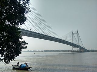
Belgharia is a locality in Kolkata of North 24 Parganas district in the Indian state of West Bengal. It is a part of the area covered by Kolkata Metropolitan Development Authority (KMDA) and a vital locality of North Kolkata. Dakshineswar Kali Temple is approximately 2 km from Belgharia. The Vivekananda Setu on the Hooghly River is one of the oldest bridges in Kolkata established for the connection between the city of Howrah and Kolkata is also at the adjacent area of Belgharia.
Kolkata Monorail was a rail-based transit project planned for the city of Kolkata, West Bengal, India. This was the first proposed monorail in the country.

Kavi Subhash is the at-grade southern terminus and interchange metro station of the North-South corridor and Bypass Corridor of Kolkata Metro in Kolkata, West Bengal, India. It is named after poet Subhash Mukhopadhyay. This station was opened to public on the auspicious day of Mahalaya in 2010.

Barasat Junction is a Kolkata Suburban Railway station in Barasat. It is one of the major suburban railway stations in North 24 Parganas district, West Bengal, India. Generally, people commuting daily use this station for travelling to Kolkata's Central Business District or other towns, with the busiest times at the station being the morning and evening peak periods. This station provides the facility of separate rest rooms for both male & female passengers. Barasat Junction Railway station consists of 6 permanent platforms.

Line 1 is a rapid transit metro line of the Kolkata Metro in Kolkata, West Bengal, India. It consists of 26 operational stations from Dakshineswar to Kavi Subhash, out of which 9 of the stations are elevated, 2 are at-grade and the remaining 15 are underground. With a total distance of 32.13 km (19.96 mi), the line connects Dakshineswar and New Garia and uses 5 ft 6 in broad gauge tracks. This line was the first underground railway to be built in India, with the first operations commencing in October 1984 and the full stretch that was initially planned being operational by February 1995. On 28 December 2010, Kolkata Metro became the 17th zone of the Indian Railways. Being the country's first, and a completely indigenous process, the construction of the Kolkata Metro Line 1 was more of a trial-and-error affair, in contrast to the Delhi Metro, which has seen the involvement of numerous international consultants. As a result, it took nearly 23 years to completely construct around 15 km (9.3 mi) underground railway from Birpara up to Tollygunge.

Line 2 is a rapid transit metro line of the Kolkata Metro in Kolkata, West Bengal, India. It currently consists of two distinctly operational sections from Salt Lake Sector-V to Sealdah, and Esplanade to Howrah Maidan by going underneath the Hooghly River. A future eastern extension from Sector-V to Teghoria is planned. It will cover a distance of 22 km (14 mi) and consist of 17 stations from Teghoria (Haldiram) in the east to Howrah Maidan in the west, of which it will consist of 11 elevated and 6 underground stations, and the operational section consists of 6 elevated and 6 underground stations, with a total distance of 13.1 km (8.1 mi). It is expected to derive a very high ridership, since it will connect India's two largest commuter railway and long-distance railway terminals, Howrah and Sealdah, along with two of its largest business districts, BBD Bagh and Salt Lake Sector V. At present, more than 100,000 passengers commute through the line every day, and this figure is expected to go up to 1 million after it gets fully completed by 2035. It will also connect the industrial hub of Kolkata, i.e., Howrah and the IT hub of Kolkata, i.e., Salt Lake Sector-V. It connects Line 1 at Esplanade and will eventually connect Lines 3 and 6.

Line 4 is a rapid transit metro line of the Kolkata Metro in Kolkata, West Bengal, India. It is a 16.876 km (10.486 mi) long line from Noapara to Barasat in North 24 Parganas, which is under construction. It is being built by RVNL, Senbo & ITD. It will run mostly on underground tunnels, the track will be elevated until Jessore Road from Noapara and then go underground towards Barasat metro station. It will have an interchange at the Kolkata Airport with Orange Line.

Line 6 is a rapid transit metro line of the Kolkata Metro in Kolkata, West Bengal, India. It will connect New Garia with Netaji Subhas Chandra Bose International Airport via two major satellite towns of Kolkata metropolitan region, Salt Lake and New Town. It currently operates between Kavi Subhash and Hemanta Mukhopadhyay. This line will be one of the most important stretches of Kolkata Metro because it will connect the southern and the eastern parts of the city with Kolkata Airport. The total distance of this route will be 29.87 km (18.56 mi). It connects Line 1 at Kavi Subhash and will eventually connect Line 2 at Sector-V and Kaikhali and Line 4 at Airport.
Line 5 is a planned rapid transit metro line of the Kolkata Metro in Kolkata, West Bengal, India. The line will run from Baranagar to Barrackpore, with a length of 12.50 km (7.77 mi). It was sanctioned in 2009, at a cost of Rs.2070 crore, to enable a quicker commuter service from the northern suburbs to Kolkata.

Jai Hind is a metro station of Kolkata Metro. It will serve the city of Kolkata's main airport, the Netaji Subhas Chandra Bose International Airport. As of October 2024 the station is planned to be open for service during March 2025.
Gour Kishore Ghosh is a station of Line 6 of the Kolkata Metro near the Chingrighata crossing, Tangra at Sukanta Nagar in Bidhannagar. The station is named in honour of famous Bengali writer and journalist, Gour Kishore Ghosh.

Nimta is a Census Town (Mofussil) in North Dumdum Municipality of Barrackpore II CD block in the Barrackpore subdivision of North 24 Parganas district in the Indian state of West Bengal. It is close to Kolkata and also a part of the area covered by Kolkata Urban Agglomeration

Jyotirindra Nandi is a metro station of Line 6 of the Kolkata Metro. The station serves Mukundapur, Santoshpur and Ajoy Nagar areas outlying the E.M. Bypass section of the city.
Kavi Sukanta is a station of Line 6 of the Kolkata Metro in Kalikapur, a southern neighbourhood of Kolkata, India, serving the areas of Kalikapur, Haltu, Prince Anwar Shah Road and Nandi Bagan. The station is named in honour of the revolutionary Bengali poet Sukanta Bhattacharya.