Teghoria

Last updated

Teghoria
Neighbourhood
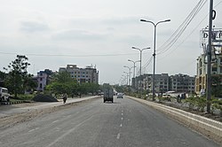
Major Arterial Road - Teghoria - Rajarhat 2012-04-11 9421.JPG
Major Arterial Road, Teghoria–Rajarhat
Kolkata location map EN.svg
Red pog.svg
Teghoria
Location in West Bengal, India
West Bengal location map.svg
Red pog.svg
Teghoria
Teghoria (West Bengal)
India location map.svg
Red pog.svg
Teghoria
Teghoria (India)
Coordinates: 22°37′22″N88°26′12″E / 22.6227°N 88.4368°E / 22.6227; 88.4368
CountryFlag of India.svg India
State West Bengal
Division Presidency
District North 24 Parganas
Metro station VIP Road (under construction)
Government
  Type Municipal Corporation
  Body Bidhannagar Municipal Corporation
Languages
  Official Bengali, English
Time zone UTC+5:30 (IST)
PIN
700136, 700157
Telephone code+91 33
Vehicle registration WB
BMC wards6, 8, 9, 11
Lok Sabha constituency Dum Dum
Vidhan Sabha constituency Rajarhat Gopalpur
Website bmcwbgov.in

Teghoria is a neighbourhood in Bidhannagar Municipal Corporation of North 24 Parganas district in the Indian state of West Bengal. It is a part of the area covered by Kolkata Metropolitan Development Authority (KMDA). [1] [2]

Contents

Geography

Teghoria
Transparent.svg
Transparent.svg
260m
283yds
Red pog.svg
Teghoria
Haldiram Bhujiawala Pure Foods, Teghoria Haldiram's - Teghoria - Kolkata 2012-04-11 9424.JPG
Haldiram Bhujiawala Pure Foods, Teghoria

Transport

Haldiram Flyover at the intersection of VIP Road and Major Arterial Road Major Arterial Road & VIP Road Flyover - Kolkata 2011-09-09 4936.JPG
Haldiram Flyover at the intersection of VIP Road and Major Arterial Road

Teghoria is the junction of VIP Road and Major Arterial Road (Haldiram crossing). Teghoria Main Road connects VIP Road to Rajarhat Main Road. Rajarhat Main Road starts from Jora Mandir (near Baguiati) and goes via Loknath Mandir, Chinar Park (crossing with 8-lane roadways Major Arterial Road) to Rajarhat Chowmatha.

Bus route numbers 45, 45A, 46, L238, D-1A, AC-39, VS-2, VS-1, V-1, AC-2, AC-37, AC-50A, AC-23A, AC-37A, AC-38, AC-43, EB-12, EB-13, S-23A, S64, C-23, C-8, 79D, 91C, 237, DN17, S-151 (Mini), S-152 (Mini), S-172 (Mini), S-175 (Mini), S-184 (Mini), 211, 211A, 211B, 215, 217, 46B, 217B etc serves the area. [3]

References

  1. "Kolkata Metropolitan Development Authority". KMDA. Retrieved 20 September 2025.
  2. "Kolkata Metropolitan Area Map". KMDA. Retrieved 20 September 2025.
  3. "Bus routes of Calcutta". Calcutta Yellow Pages. Retrieved 20 September 2025.