Slovenia officially the Republic of Slovenia is a country in Central Europe. It borders Italy to the west, Austria to the north, Hungary to the northeast, Croatia to the south and southeast, and a short coastline within the Adriatic Sea to the southwest, which is part of the Mediterranean sea. Slovenia is mostly mountainous and forested, covers 20,271 square kilometres (7,827 sq mi), and has a population of approximately 2.1 million. Slovene is the official language. Slovenia has a predominantly temperate continental climate, with the exception of the Slovene Littoral and the Julian Alps. Ljubljana, the capital and largest city of Slovenia, is geographically situated near the centre of the country. Other larger urban centers are Maribor, Kranj, Celje and Koper.

Carinthia, also Slovene Carinthia or Slovenian Carinthia, is a traditional region in northern Slovenia. The term refers to the small southeasternmost area of the former Duchy of Carinthia, which after World War I was allocated to the State of Slovenes, Croats and Serbs according to the 1919 Treaty of Saint-Germain. It has no distinct centre, but a local centre in each of the three central river valleys among the heavily forested mountains.
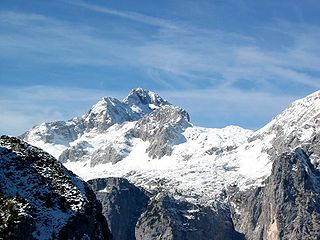
Slovenia offers tourists a wide variety of landscapes: Alpine in the northwest, Mediterranean in the southwest, Pannonian in the northeast, and Dinaric in the southeast. They roughly correspond to the traditional regions of Slovenia, based on the former four Habsburg crown lands. Each offers its own natural, geographic, architectural, and cultural features. Slovenia has mountains, meadows, lakes, caves, and the sea, making it an attractive destination in Europe.

The Karawanks or Karavankas or Karavanks are a mountain range of the Southern Limestone Alps on the border between Slovenia to the south and Austria to the north. With a total length of 120 kilometres (75 mi) in an east–west direction, the Karawanks chain is one of the longest ranges in Europe. It is traversed by important trade routes and has a great tourist significance. Geographically and geologically, it is divided into the higher Western Karawanks and the lower-lying Eastern Karawanks. It is traversed by the Periadriatic Seam, separating the Apulian tectonic plate from the Eurasian Plate.

Inner Carniola is a traditional region of Slovenia, the southwestern part of the larger Carniola region. It comprises the Hrušica karst plateau up to Postojna Gate, bordering the Slovenian Littoral in the west. Its administrative and economic center of the region is Postojna, and other minor centers include Vrhnika, Logatec, Cerknica, Pivka, and Ilirska Bistrica.

Ilirska Bistrica is a town in the Inner Carniola region of southwestern Slovenia. It is the administrative seat of the Municipality of Ilirska Bistrica.
Rak Škocjan is a valley and a landscape park, part of Inner Carniola Regional Park in southwestern Slovenia. Administratively, it belongs to the settlement of Rakov Škocjan. Rak Škocjan has been protected since 1949 and is the oldest landscape park in Slovenia.

Srednja Dobrava is a settlement in the Municipality of Radovljica in the Upper Carniola region of Slovenia.

Škocjan Caves is a cave system located in Slovenia. Škocjan Caves was included on UNESCO’s list of natural and cultural World Heritage Sites in 1986. Škocjan Caves is a significant underground phenomenon on the Karst Plateau and in Slovenia. After gaining independence from Yugoslavia in 1991, Slovenia made a commitment to actively protect the Škocjan Caves area. To fulfill this commitment, Škocjan Caves Regional Park was established, along with its managing authority, the Škocjan Caves Park Public Service Agency.
Škocjan Caves Regional Park is located in the Škocjan Karst, a vast flat landscape that lies at an elevation between 420 and 450 m in the southeast part of the Karst area. Following its independence, Slovenia committed itself to protecting the Škocjan Caves area; for this reason, it established Škocjan Caves Regional Park and its managing authority, the Škocjan Caves Park Public Service Agency.

The Prešeren Monument in Ljubljana, also Prešeren Statue in Ljubljana, is a late Historicist bronze statue of the Slovene national poet France Prešeren in Ljubljana, the capital of Slovenia. It stands in the eastern side of Prešeren Square, in front of the Central Pharmacy Building in Ljubljana, the capital of Slovenia. It is among the best-known Slovenian monuments.

Pavel Kunaver was a Slovene pedagogue, writer of popular science books, geography, history and Slovene language teacher and pioneer of amateur astronomy, mountain climbing, skiing and caving in Slovenia.

The Municipality of Naklo is one of the municipalities in northwestern Slovenia. Its seat is Naklo. The municipality, established in 1994, lies at an elevation of 407 metres (1,335 ft) and has 5,020 residents. It has an area of 28.3 square kilometres (10.9 sq mi).

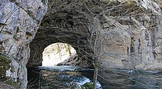
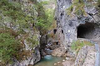
Weaver Cave —also known as Vaulted Cave, Škocjan Cave, and Inlet Cave —is a 2,885 metres (9,465 ft) long ponor cave in southwest Slovenia. It runs from the west (downstream) side of the Rak Škocjan Valley, where it has two entrances, and continues into Planina Cave. It is traversed by Rak Creek, part of the Ljubljanica source system. It thus forms part of the hydrological connection between Cerknica Polje and Planina Polje. Due to sumps, the stream of the Rak is very difficult to follow and was explored by divers only in 1974, when the majority of the cave was discovered in the course of a rescue expedition, and in August 2012.
The Slovenian Mountain Hiking Trail, sometimes also called Transverzala, is a route from Maribor to Ankaran. It covers most of the Slovenian mountain areas including Pohorje, the Julian Alps, the Kamnik-Savinja Alps, the Karawanks, and the southwestern part of Slovenia. It is the oldest hiking track in Europe.
The Municipality of Mirna Peč is a municipality in southeast Slovenia, located in the traditional region of Lower Carniola. The seat of the municipality, which was established in 1998, is Mirna Peč. With an estimated population of 2,800, the municipality is included in the Southeast Slovenia Statistical Region.

The Udin Woods is one of the oldest glacial terraces in the Ljubljana Basin. It is a contiguous wooded area clearly delineated from its surroundings. The woods is dominated by Scots pine, and deciduous trees include sessile oak, hornbeam, and beech. It has natural value in terms of its botanical features, terrain, and geomorphology. It was given the status of a protected landscape area in 1985.

The Bloke Plateau is an extensive bowl-like plateau in southern Slovenia, part of the traditional region of Inner Carniola.
The Dovžan Gorge is a gorge in Slovenia that was carved by the Tržič Bistrica River. The river flows through unique waterfalls over large rounded blocks of white quartz conglomerate. These large blocks tumbled into the river from Pine Cliff above the right bank, named after the Scots pine that overgrows its steep slopes.