List of unconfirmed impact craters on Earth

Last updated
Map all coordinates using: OpenStreetMap  
Download coordinates as: KML  ·  GPX

This list of more than 130 features on Earth includes candidate impact sites that have appeared several times in the literature and/or have been endorsed by the Impact Field Studies Group (IFSG) [1] and/or Expert Database on Earth Impact Structures (EDEIS), [2] . None has been scientifically confirmed to be an impact crater, according to the Earth Impact Database (EID). [3]

The Impact Field Studies Group (IFSG) is a scientific organization emphasizing geologic field research of suspected and confirmed sites of impact craters and impact structures. The group is composed of researchers, professionals and students involved in study of impact sites. IFSG's web site is hosted by the Department of Earth and Planetary Sciences at University of Tennessee, Knoxville.

Earth Impact Database

The Earth Impact Database is a database of confirmed impact structures or craters on Earth. It was initiated in 1955 by the Dominion Observatory, Ottawa, under the direction of Dr. Carlyle S. Beals. Since 2001, it has been maintained as a not-for-profit source of information at the Planetary and Space Science Centre at the University of New Brunswick, Canada.

Contents

Misidentified or unconfirmed impact features

The following tables list geological features on Earth that some individuals have associated with impact events, but for which there is currently no confirming scientific evidence in the peer-reviewed literature. In order for a structure to be a confirmed as an impact crater, it must meet a stringent set of well established criteria. Some proposed impact structures are eventually confirmed, whereas others are shown to be misidentified (see below). Recent extensive surveys have been done for Australian (2005), [4] African (2014), [5] and South American (2015) [6] craters, as well as those in the Arab world (2016). [7] A book review by A. Crósta and U. Reimold disputes some of the evidence presented for several of the South American structures. [8]

Ak-Bura (Murgab) Ak-Bura 2.png
Ak-Bura (Murgab)
False-colour Landsat image of Darwin Crater (arrowed) Darwin Crater Landsat.jpg
False-colour Landsat image of Darwin Crater (arrowed)
Topographic image of Iturralde Crater Iturralde Crater PIA03359 cropped.jpg
Topographic image of Iturralde Crater
Zerelia West and East Zerelia West and East.png
Zerelia West and East
Tonle Sap lake French Indochina map.jpg
Tonlé Sap lake
NameLocationDiameter
(km)
Age
Date
(approx.)
Coordinates
Lake Cheko [ citation needed ]Russia (Siberia)0.5[ citation needed ]? 1908 AD [ citation needed ] 60°57′50″N101°51′36″E / 60.964°N 101.86°E / 60.964; 101.86 (Cheko)
Ak-Bura (Murgab) [9] [10] Tajikistan 0.8[ citation needed ]0.3 ka [ citation needed ]1700 AD [11] 38°5′38.5″N74°16′58″E / 38.094028°N 74.28278°E / 38.094028; 74.28278 (Ak-Bura)
Mahuika [ citation needed ]New Zealand (offshore)20?0.6 ka [ citation needed ]1400 AD[ citation needed ] 48°18′S166°24′E / 48.3°S 166.4°E / -48.3; 166.4 (Mahuika)
Merewether [12] Canada (Newfoundland)0.2[ citation needed ]0.9 ka [ citation needed ]1100 AD[ citation needed ] 58°02′N64°03′W / 58.04°N 64.05°W / 58.04; -64.05 (Merewether)
Sirente [ citation needed ]Italy0.1[ citation needed ]1.7 ka [ citation needed ]320 ± 90 AD[ citation needed ] 42°10′38″N13°35′45″E / 42.17722°N 13.59583°E / 42.17722; 13.59583 (Sirente)
Svetloyar lake [13] Russia0.4[ citation needed ]2.6 ka [ citation needed ]600 BC[ citation needed ] 56°49′08″N45°05′35″E / 56.819°N 45.093°E / 56.819; 45.093 (Svetloyar)
Kachchh (Luna) [14] India2.1[ citation needed ]4.0 ka [ citation needed ]2000 BC[ citation needed ] 23°42′17″N69°15′37″E / 23.70472°N 69.26028°E / 23.70472; 69.26028 (Kachchh)
Umm al Binni [ citation needed ] Iraq 3.4[ citation needed ]<5.0 ka [ citation needed ]3000 BC[ citation needed ] 31°14′29″N47°06′21″E / 31.24139°N 47.10583°E / 31.24139; 47.10583 (Umm al Binni)
Burckle [ citation needed ] Indian Ocean [ citation needed ]30??3000 BC[ citation needed ] 30°52′S61°22′E / 30.86°S 61.36°E / -30.86; 61.36 (Burckle)
Zerelia West [15] Greece0.2[ citation needed ]7.0 ka [ citation needed ]5000 BC[ citation needed ] 39°09′48″N22°42′32″E / 39.16333°N 22.70889°E / 39.16333; 22.70889 (Zerelia West)
Zerelia East [15] Greece0.1[ citation needed ]7.0 ka [ citation needed ]5000 BC[ citation needed ] 39°09′43″N22°42′51″E / 39.16194°N 22.71417°E / 39.16194; 22.71417 (Zerelia East)
Smerdyacheye lake [16] Russia0.2[ citation needed ]10–30? ka [ citation needed ] 55°44′06″N39°49′23″E / 55.735°N 39.823°E / 55.735; 39.823 (Smerdyacheye)
Hickman Crater [ citation needed ]Australia0.3[ citation needed ]10–100 ka [ citation needed ] 23°2′13″S119°40′59″E / 23.03694°S 119.68306°E / -23.03694; 119.68306 (Hickman)
Bloody Creek [ citation needed ]Canada (Nova Scotia)0.4[ citation needed ]? 44°45′N65°14′W / 44.750°N 65.233°W / 44.750; -65.233 (Bloody Creek)
Iturralde [ citation needed ] Bolivia 8.011–30 ka [ citation needed ] 12°35′S67°40′W / 12.583°S 67.667°W / -12.583; -67.667 (Iturralde)
Brushy Creek Feature [17] United States (Louisiana)2.0[ citation needed ]11–30 ka [ citation needed ] 30°46′N90°44′W / 30.76°N 90.73°W / 30.76; -90.73 (Brushy Creek Feature)
Ouro Ndia [18] Mali 3.0[ citation needed ]11–100? ka [11] 14°59.8′N4°30.0′W / 14.9967°N 4.5000°W / 14.9967; -4.5000 (Ouro Ndia)
Mt. Oikeyama [19] Japan0.9[ citation needed ]30? ka [ citation needed ] 35°24′18″N138°00′47″E / 35.405°N 138.013°E / 35.405; 138.013 (Oikeyama)
Sithylemenkat lake [20] United States (Alaska)1233? ka [21] [22] 66°07′34″N151°23′20″W / 66.12611°N 151.38889°W / 66.12611; -151.38889 (Sithylemenkat)
La Dulce crater [23] Argentina 2.8[ citation needed ]445? ka [ citation needed ] 38°13′S59°13′W / 38.21°S 59.21°W / -38.21; -59.21 (La Dulce)
Bajada del Diablo craters [24] [25] Argentina 0.4[ citation needed ]450 ± 300 ka [ citation needed ] 42°46′S67°24′W / 42.767°S 67.400°W / -42.767; -67.400 (Bajada del Diablo)
Darwin Crater [ citation needed ] Tasmania 1.2[ citation needed ]816 ka [ citation needed ] 42°19′S145°40′E / 42.317°S 145.667°E / -42.317; 145.667 (Darwin crater)
Pantasma [ citation needed ] Nicaragua 10? 13°22′N85°57′W / 13.37°N 85.95°W / 13.37; -85.95 (Pantasma)
38th Parallel structures [ citation needed ]United States (Missouri, etc.)2-17?
Al Madafi [26] [27] Saudi Arabia 66-66 Ma [26] [27] 28°40′N37°11′E / 28.67°N 37.18°E / 28.67; 37.18 (Al Madafi)
Alamo bolide impact [ citation needed ]United States (Nevada)100 ± 40 [11] [28] 367 Ma [ citation needed ] 37°19′N116°11′W / 37.31°N 116.18°W / 37.31; -116.18 (Alamo)
Anefis [18] [29] Chad 3.9[ citation needed ]23? Ma [11] 18°04′19″N0°02′53″W / 18.072°N 0.048°W / 18.072; -0.048 (Anefis)
Aorounga Central [30] [31] Chad 11.6< 345 Ma [ citation needed ] 19°13′44″N19°15′40″E / 19.229°N 19.261°E / 19.229; 19.261 (Aorounga center)
Arganaty [32] Kazakhstan (Almaty region)300250 Ma [33] 46°30′N79°48′E / 46.5°N 79.8°E / 46.5; 79.8 (Arganaty)
Arlit crater [34] [35] Niger 10? 21°21′11″N9°08′42″E / 21.353°N 9.145°E / 21.353; 9.145 (Arlit)
Australian impact structure [ citation needed ]Australia (Northern Territory)600 >545 Ma [ citation needed ] 25°33′S131°23′E / 25.550°S 131.383°E / -25.550; 131.383 (MAPCIS)
Azuara [ citation needed ]Spain35-4030-40 Ma [ citation needed ] 41°07′N0°13′W / 41.117°N 0.217°W / 41.117; -0.217 (Azuara)
Bajo Hondo [36] Argentina 3.9< 10 Ma [ citation needed ] 42°15′S67°55′W / 42.250°S 67.917°W / -42.250; -67.917 (Bajo Hondo)
Bangui magnetic anomaly [5] [37] Central African Republic 600-800? >542 Ma [ citation needed ] 6°00′N18°18′E / 6°N 18.3°E / 6; 18.3 (Bangui)
Bateke Plateau [38] Gabon 7.1< 2.6 0°38′45″S14°27′29″E / 0.64583°S 14.45806°E / -0.64583; 14.45806 (Bateke)
Bedout [ citation needed ]Australia (offshore)250250 Ma [ citation needed ] 18°S119°E / 18°S 119°E / -18; 119 (Bedout)
Bee Bluff [39] United States (Texas)2.440? Ma [ citation needed ] 29°02′N99°51′W / 29.03°N 99.85°W / 29.03; -99.85 (Bee Bluff)
Björkö [40] Sweden101200 Ma [ citation needed ] 59°18′N17°36′E / 59.30°N 17.60°E / 59.30; 17.60 (Björkö)
Bohemian circular structure [41] [42] Czech Republic 260-300>700? Ma [11] 50°00′N14°42′E / 50.0°N 14.7°E / 50.0; 14.7 (Bohemian)
Bow City [ citation needed ]Canada (Alberta)870 Ma [ citation needed ] 50°25′N112°16′W / 50.417°N 112.267°W / 50.417; -112.267 (Bow City)
Bowers crater [43] Antarctic Ocean (Ross Sea)1003-5 Ma [44] [45] 71°12′S176°00′E / 71.2°S 176°E / -71.2; 176 (Bowers)
Catalina structures [46]
(Navy, Catalina, Emery Knoll)
Pacific Ocean (NE)12, 32, 3716-18 Ma [ citation needed ] 32°55′N118°05′W / 32.91°N 118.09°W / 32.91; -118.09 (Catalina)
Cerro do Jarau [47] [48] Brazil (Paraná)10117 Ma [ citation needed ] 30°12′S56°32′W / 30.200°S 56.533°W / -30.200; -56.533 (Cerro)
Charity Shoal Crater [ citation needed ]Canada (Ontario)1.2<470 Ma [ citation needed ] 44°2′15″N76°29′37″W / 44.03750°N 76.49361°W / 44.03750; -76.49361 (Charity Shoal)
Corossol [ citation needed ]Canada (Quebec)4<470 Ma [ citation needed ] 50°03′N66°23′W / 50.050°N 66.383°W / 50.050; -66.383 (Corossol)
Decorah crater{ [49] United States (Iowa)5.6470 Ma [50] 43°18′50″N91°46′20″W / 43.31389°N 91.77222°W / 43.31389; -91.77222 (Decorah)
Dumas magnetic anomaly [51] Canada (Saskatchewan)3.270 ± 5 Ma [ citation needed ] 49°55′N102°07′W / 49.92°N 102.12°W / 49.92; -102.12 (Dumas)
Duolun [52] China (Inner Mongolia)120 ± 50129 ± 3 Ma [ citation needed ] 42°3′N116°15′E / 42.050°N 116.250°E / 42.050; 116.250 (Duolun)
El-Baz [31] [53] Egypt 4? 24°12′N26°24′E / 24.200°N 26.400°E / 24.200; 26.400 (El-Baz)
Eltanin impact [ citation needed ] Pacific Ocean (SE)35?2.5 Ma [ citation needed ] 57°47′S90°47′W / 57.783°S 90.783°W / -57.783; -90.783 (Eltanin)
Faya Basin [54] Chad 2385 ± 15 Ma [ citation needed ] 18°10′N19°34′E / 18.167°N 19.567°E / 18.167; 19.567 (Faya)
Falkland Plateau
anomaly [55] [56] [57] [58]
Atlantic Ocean
(near the Falkland Islands)
250-300250 Ma [11] 51°S62°W / 51°S 62°W / -51; -62 (Malvinas)
Fried Egg structure [59] Atlantic Ocean 617 Ma [ citation needed ] 36°N27°W / 36°N 27°W / 36; -27 (Fried Egg)
Garet El Lefet [60] [61] Libya 3? 25°00′N16°30′E / 25.0°N 16.5°E / 25.0; 16.5 ("Garet El Lefet")
Gatun structure [ citation needed ] Panama 320 Ma [ citation needed ] 09°05′58″N79°47′22″W / 9.09944°N 79.78944°W / 9.09944; -79.78944 (Gatun structure)
General San Martin [23] [62] Argentina 111.2 Ma [ citation needed ] 38°0′S63°18′W / 38.000°S 63.300°W / -38.000; -63.300 (General San Martin)
Gnargoo [63] Australia (Western Australia)75<300 Ma [ citation needed ] 24°48′24″S115°13′29″E / 24.80667°S 115.22472°E / -24.80667; 115.22472 (Gnargoo)
Guarda [ citation needed ] Portugal 30200 Ma [ citation needed ] 40°38′N07°06′W / 40.633°N 7.100°W / 40.633; -7.100 (Guarda)
Hiawatha crater [ citation needed ] Greenland 31[ citation needed ]<1985 [64] 78°44′N66°14′W / 78.733°N 66.233°W / 78.733; -66.233 (Hiawatha)
Hartney anomaly [51] [65] Canada (Manitoba)8120 ± 20 Ma [ citation needed ] 49°24′N100°40′W / 49.4°N 100.67°W / 49.4; -100.67 (Hartney)
Hico structure [66] United States (Texas)9< 60 Ma [ citation needed ] 32°01′N98°02′W / 32.01°N 98.03°W / 32.01; -98.03 (Hico)
Hotchkiss [67] Canada (Alberta)4220 ± 100 Ma [ citation needed ] 57°32′20″N118°52′41″W / 57.539°N 118.878°W / 57.539; -118.878 (Hotchkiss)
Howell structure [68] [69] United States (Tennessee)2.5380 ± 10 Ma [ citation needed ] 35°14′N86°37′W / 35.23°N 86.61°W / 35.23; -86.61 (Howell)
Ibn-Batutah [70] Libya 2.5120 ± 20 Ma [ citation needed ] 21°34′10″N20°50′15″E / 21.56944°N 20.83750°E / 21.56944; 20.83750 (Ibn-Batutah)
Ishim impact structure [71] [ citation needed ] Kazakhstan (Akmola region)300430-460 Ma [72] 52°0′N69°0′E / 52.000°N 69.000°E / 52.000; 69.000 (Ishim Akmola)
Jackpine Creek
magnetic anomaly [73]
Canada (British Columbia)25120 ± 20 Ma [ citation needed ] 55°36′N120°06′W / 55.6°N 120.1°W / 55.6; -120.1 (Jackpine)
Jebel Hadid [74] Libya 4.7< 66 Ma [ citation needed ] 20°52′12″N22°42′18″E / 20.87000°N 22.70500°E / 20.87000; 22.70500 (Jebel Hadid)
Jeptha Knob [ citation needed ]United States (Kentucky)4.3425 Ma [ citation needed ] 38°11′N85°07′W / 38.183°N 85.117°W / 38.183; -85.117 (Jeptha Knob)
Jwaneng South [75] Botswana 1.3< 66 Ma [ citation needed ] 24°42′S24°46′E / 24.700°S 24.767°E / -24.700; 24.767 (Jwaneng South)
Kebira [ citation needed ] Egypt 31100 Ma [ citation needed ] 24°40′N24°58′E / 24.667°N 24.967°E / 24.667; 24.967 (Kebira)
Kilmichael [76] United States (Mississippi)1345 Ma [ citation needed ] 33°30′N89°33′W / 33.5°N 89.55°W / 33.5; -89.55 (Kilmichael)
Krk structure [77] Croatia 1240 Ma [ citation needed ] 45°04′N14°37′E / 45.06°N 14.62°E / 45.06; 14.62 (Krk)
Kurai Basin [78] Russia (Altai)20<200 Ma [ citation needed ] 50°12′N87°54′E / 50.200°N 87.900°E / 50.200; 87.900 (Kurai)
Labynkyr ring [79] [80] Russia67150? Ma [11] 62°19′30″N143°05′24″E / 62.325°N 143.090°E / 62.325; 143.090 (Labynkyr)
Lairg Gravity Low [ citation needed ] Scotland 401200 Ma [ citation needed ] 58°1′12″N, 4°24′0″W [ citation needed ]
Lake Iro (Lac Iro) [5] [81] Chad 13? 10°10′N19°40′E / 10.167°N 19.667°E / 10.167; 19.667 (Iro Lake)
Lake Tai (Tai Hu) [82] China (Jiangsu)70 ± 5365 ± 5 Ma [83] 31°14′N120°8′E / 31.233°N 120.133°E / 31.233; 120.133 (Tai)
Loch Leven [84] Scotland18x8290 Ma [ citation needed ] 56°12′N3°23′W / 56.200°N 3.383°W / 56.200; -3.383 (Loch Leven)
Lorne Basin [85] Australia (New South Wales)30250 ± 2 Ma [ citation needed ] 31°36′S152°37′E / 31.60°S 152.62°E / -31.60; 152.62 (Lorne)
Lycksele structure [86] [87] Sweden1301500 ± 300 Ma [ citation needed ] 64°55′N18°47′E / 64.92°N 18.78°E / 64.92; 18.78 (Lycksele)
Madagascar structure 3 [88] Madagascar 12? 18°50′20″S46°13′16″E / 18.839°S 46.221°E / -18.839; 46.221 (Madagascar)
Magyarmecske anomaly [89] Hungary7299 Ma [ citation needed ] 45°57′N17°58′E / 45.95°N 17.97°E / 45.95; 17.97 (Magyarmecske)
Maniitsoq structure [90] [91] Greenland 1003000 Ma [ citation needed ] 65°15′N51°50′W / 65.250°N 51.833°W / 65.250; -51.833 (Maniitsoq)
Mejaouda (El Mrayer) [61] [18] [92] Mauritania 3< 542? Ma [11] 22°43′19″N7°18′43″W / 22.722°N 7.312°W / 22.722; -7.312 (Mejaouda)
Meseta de la Barda Negra [93] Argentina 1.54 ± 1 Ma [ citation needed ] 39°10′S69°53′W / 39.167°S 69.883°W / -39.167; -69.883 (Barda Negra)
Middle-Urals Ring Structure [94] [95] Russia400–550 >542 Ma [ citation needed ] 56°N56°E / 56°N 56°E / 56; 56 (Urals Ring)
Mistassini-Otish impact structure [ citation needed ]Quebec, Canada)600 [96] 2200 Ma [ citation needed ] 50°34′N73°25′W / 50.57°N 73.42°W / 50.57; -73.42 (Mistassini lake)
Mount Ashmore dome [97] [98] Indian Ocean (in Timor Sea)>5035 Ma [ citation needed ]
Mousso [99] Chad 3.8< 542 Ma [ citation needed ] 17°58′N10°53′E / 17.967°N 10.883°E / 17.967; 10.883 (Mousso)
Mulkarra [100] Australia (South Australia)17105 Ma [ citation needed ] 27°51′S138°55′E / 27.85°S 138.92°E / -27.85; 138.92 (Mulkarra)
Nastapoka (Hudson Bay) arc [ citation needed ]Canada (Quebec)4501800? Ma [11] 57°00′N78°50′W / 57.000°N 78.833°W / 57.000; -78.833 (Hudson Bay)
Ouro Ndia [18] Mali3<2.6 Ma [ citation needed ] 14°59′N4°30′W / 14.983°N 4.500°W / 14.983; -4.500 (Ouro Ndia)
Panther Mountain [ citation needed ]United States (New York)10375 Ma [ citation needed ] 42°03′N74°24′W / 42.050°N 74.400°W / 42.050; -74.400 (Panther Mountain)
Peerless structure [101] United States (Montana)6470 ± 10 Ma [ citation needed ] 48°48′N105°48′W / 48.8°N 105.8°W / 48.8; -105.8 (Peerless)
Piratininga [47] Brazil (Paraná)12117 Ma [ citation needed ] 22°28′S49°09′W / 22.467°S 49.150°W / -22.467; -49.150 (Piratininga)
Praia Grande [47] [48] Brazil (São Paulo, offshore)2084 Ma [ citation needed ] 25°39′S45°37′W / 25.650°S 45.617°W / -25.650; -45.617 (prai grande)
Ramgarh [ citation needed ]India (Rajasthan)3? 25°20′16″N76°37′29″E / 25.33778°N 76.62472°E / 25.33778; 76.62472 (Ramgarh)
Ross crater [44] [ citation needed ] Antarctic Ocean (Ross Sea)600?<38 Ma [ citation needed ] 77°30′S178°30′E / 77.5°S 178.5°E / -77.5; 178.5 (Ross)
Rubielos de la Cérida [ citation needed ]Spain80x4030-40 Ma [ citation needed ] 40°46′59″N1°15′00″W / 40.783°N 1.25°W / 40.783; -1.25 (Rubielos)
Sakhalinka [102] Pacific Ocean (NW)1270 Ma [ citation needed ] 30°15′N170°03′E / 30.250°N 170.050°E / 30.250; 170.050 (Sakhalinka)
São Miguel do Tapuio [48] [103] Brazil (Piauí)22120 Ma [11] [ citation needed ] 5°37.6′S41°23.3′W / 5.6267°S 41.3883°W / -5.6267; -41.3883 (Sao Miguel Do Tapuio)
Shanghewan [104] [105] China (Jilin)30? 44°29′N126°11′E / 44.483°N 126.183°E / 44.483; 126.183 (Shangewan)
Shiva crater [ citation needed ] Indian Ocean 50066 Ma [ citation needed ] 18°40′N70°14′E / 18.667°N 70.233°E / 18.667; 70.233 (Shiva)
Shiyli dome [106] Kazakhstan 5.546 ± 7 Ma [ citation needed ] 49°10′N57°51′E / 49.167°N 57.850°E / 49.167; 57.850 (Shiyli)
Silverpit [ citation needed ] Atlantic Ocean (North Sea)20 [107] 60 ± 15 Ma [ citation needed ] 54°14′N1°51′E / 54.233°N 1.850°E / 54.233; 1.850 (Silverpit)
Snows Island (Johnsonville) [ citation needed ]United States (South Carolina)11300? Ma [11] [ citation needed ] 33°49′N79°22′W / 33.817°N 79.367°W / 33.817; -79.367 (Snows Island)
Sudan 3 (Mahas)[ citation needed ] Sudan 2.8? 20°01.9′N30°13.7′E / 20.0317°N 30.2283°E / 20.0317; 30.2283 (Mahas)
Sudan 2 (Bayuda) [108] [109] Sudan 10? 18°03.5′N33°30.2′E / 18.0583°N 33.5033°E / 18.0583; 33.5033 (Bayuda)
Sudan 1 (Red Sea Hills) [110] Sudan 6? 17°57.1′N37°56.1′E / 17.9517°N 37.9350°E / 17.9517; 37.9350 (Red Sea)
Takamatsu [111] Japan4-815 Ma [ citation needed ] 34°18′N134°03′E / 34.3°N 134.05°E / 34.3; 134.05 (Takamatsu)
Tarek (Gilf Kebir) [112] [113] Egypt 2.1112? Ma [11] 24°36′04″N27°12′18″E / 24.601°N 27.205°E / 24.601; 27.205 (Tarek)
Tatarsky North [114] Pacific Ocean (NW)14? 49°57′35″N141°23′40″E / 49.95972°N 141.39444°E / 49.95972; 141.39444 (Tatarsky1)
Tatarsky South [114] [ citation needed ] Pacific Ocean (NW)20? 48°17′38″N141°23′40″E / 48.29389°N 141.39444°E / 48.29389; 141.39444 (Tatarsky2)
Tefé River structure [48] [115] Brazil (Amazonas)1565 ± 20 Ma [ citation needed ] 4°57′S66°03′W / 4.950°S 66.050°W / -4.950; -66.050 (Tefé)
Talundilly [116] Australia (Queensland)84128 ± 5 Ma [ citation needed ] 24°44′S144°37′E / 24.73°S 144.62°E / -24.73; 144.62 (Talundilly)
Temimichat [117] Mauritania 0.72? Ma [11] 24°15′N9°39′W / 24.250°N 9.650°W / 24.250; -9.650 (Temimichat)
Tsenkher [118] Mongolia 3.65 Ma [ citation needed ] 43°38′41″N98°22′09″E / 43.64472°N 98.36917°E / 43.64472; 98.36917 (Tsenkher)
Toms Canyon [ citation needed ]United States (New Jersey)2235 Ma [ citation needed ] 39°08′N72°51′W / 39.133°N 72.850°W / 39.133; -72.850 (Toms Canyon)
Unnamed impact [119] Australia (Queensland)[ citation needed ]130300 Ma [ citation needed ] 22°09′S141°54′E / 22.150°S 141.900°E / -22.150; 141.900 (Winton crustal anomaly)
Ust-Kara [120] Russia (Nenetsia, offshore)2570 ± 2.2 Ma [ citation needed ] 69°17′N65°21′E / 69.28°N 65.35°E / 69.28; 65.35 (Ust-Kara)
Vélingara [121] Senegal 4823-40 Ma [ citation needed ] 13°02′N14°08′W / 13.033°N 14.133°W / 13.033; -14.133 (Vélingara)
Versailles cryptoexplosion [122] United States (Kentucky)1.5<400 Ma [ citation needed ] 38°05′N84°40′W / 38.09°N 84.67°W / 38.09; -84.67 (Versailles)
Vichada Structure [ citation needed ] Colombia 5030? Ma [11] 4°30′N69°15′W / 4.500°N 69.250°W / 4.500; -69.250 (Vichada)
Victoria Island structure [ citation needed ]United States (California)5.537-49 Ma [ citation needed ] 37°53′N121°32′W / 37.89°N 121.53°W / 37.89; -121.53 (Victoria Island structure)
Warburton East [123] [124] Australia (South Australia)200300-360 Ma [125] [ citation needed ] 28°00′S140°30′E / 28°S 140.5°E / -28; 140.5 (Warbuton)
Warburton West [124] [ citation needed ]Australia (South Australia)200300-360 Ma [125] [ citation needed ]
Weaubleau structure [ citation needed ]United States (Missouri)19330 ± 10 Ma [ citation needed ] 38°00′N93°36′W / 38.0°N 93.6°W / 38.0; -93.6 (Weaubleau)
Wembo-Nyama (Omeonga)
ring structure
[126] [127]
DR Congo 36-4660? Ma [ citation needed ] 3°37′52″S24°31′07″E / 3.63111°S 24.51861°E / -3.63111; 24.51861 (Wembo-Nyama ring structure)
Wilkes Land crater [ citation needed ] Antarctica 480250-500 Ma [ citation needed ] 70°S120°E / 70°S 120°E / -70; 120 (Wilkes)
Woodbury astrobleme [128] United States (Georgia)7500 ± 100 Ma [ citation needed ] 32°55′N84°33′W / 32.92°N 84.55°W / 32.92; -84.55 (Woodbury)
Yallalie [129] [130] Australia (Western Australia)1299? Ma [11] 30°26′40″S115°46′16″E / 30.44444°S 115.77111°E / -30.44444; 115.77111 (Yallalie)

The Cheko crater is thought by one research group to be the result of the famous Tunguska event, although sediments in the lake have been dated back more than 5,000 years. There is highly speculative conjecture about the supposed Sirente impact (c. 320 ± 90 AD) causing the Roman emperor Constantine's vision at Milvian Bridge. [131]

Lake Cheko lake in Krasnoyarsk Krai, Russia

Lake Cheko is a small freshwater lake in Siberia, near the Podkamennaya Tunguska River, in what is now the Evenkiysky District of the Krasnoyarsk Krai.

Tunguska event powerful explosion that occurred near the Podkamennaya Tunguska River

The Tunguska event was a large explosion that occurred near the Stony Tunguska River in Yeniseysk Governorate, Russia, on the morning of 30 June 1908 (NS). The explosion over the sparsely populated Eastern Siberian Taiga flattened 2,000 square kilometres of forest, yet caused no known human casualties. The explosion is generally attributed to the air burst of a meteor. It is classified as an impact event, even though no impact crater has been found; the object is thought to have disintegrated at an altitude of 5 to 10 kilometres rather than to have hit the surface of the Earth.

The Sirente crater is a small shallow seasonal lake in Abruzzo, central Italy. The depression, which is located at the center of the Prati del Sirente, a mountainous highland north of the Sirente massif in the Apennines, is 13 km (8.1 mi) from the village of Secinaro. Its formation has prompted a number of theories in recent years. Although in the absence of shock-metamorphic and / or geochemical evidence it is not yet possible to confirm the meteoritic impact theory, no other theories for the origin of this geological structure have been proven yet.

The Burckle crater and Umm al Binni structure are proposed to be behind the floods that affected Sumerian civilization. [132] [133] The Kachchh impact may have been witnessed by the Harappan civilization and mentioned as a fireball in Sanskrit texts. [14]

Umm al Binni lake is a mostly dry lake within the Central Marshes in Maysan Governorate in southern Iraq. The 3.4 km wide lake is approximately 45 km northwest of the Tigris–Euphrates confluence. Because of its shape, location, and other details, it has been conjectured to represent an impact crater.

Sumer Ancient civilization and historical region in southern Mesopotamia

Sumer is the earliest known civilization in the historical region of southern Mesopotamia, modern-day southern Iraq, during the Chalcolithic and Early Bronze ages, and one of the first civilizations in the world along with Ancient Egypt and the Indus Valley. Living along the valleys of the Tigris and Euphrates, Sumerian farmers were able to grow an abundance of grain and other crops, the surplus of which enabled them to settle in one place. Prehistoric proto-writing dates back before 3000 BC. The earliest texts, from c. 3300 BC, come from the cities of Uruk and Jemdet Nasr; early cuneiform script emerged around 3000 BC.

Sanskrit language of ancient India

Sanskrit is a language of ancient India with a history going back about 3,500 years. It is the primary liturgical language of Hinduism and the predominant language of most works of Hindu philosophy as well as some of the principal texts of Buddhism and Jainism. Sanskrit, in its variants and numerous dialects, was the lingua franca of ancient and medieval India. In the early 1st millennium CE, along with Buddhism and Hinduism, Sanskrit migrated to Southeast Asia, parts of East Asia and Central Asia, emerging as a language of high culture and of local ruling elites in these regions.

The ages of the Bloody Creek crater [134] and Hiawatha crater are disputed, with some evidence suggesting it hit glacier ice 12,000-13,000 years ago, coeval with the Younger Dryas.

Bloody Creek crater

Bloody Creek crater, which is also known as the Bloody Creek structure, is a 420-by-350-meter in diameter elliptical feature that is located in southwestern Nova Scotia, Canada. It is argued to be either a possible extraterrestrial impact crater or an impact structure. It lies between Bridgetown and West Dalhousie, Annapolis County, Nova Scotia, where the Bloody Creek structure straddles what was once a stretch of Bloody Creek. It also is informally known as the Astrid crater.

Hiawatha Glacier glacier in Greenland

Hiawatha Glacier is a glacier in northwest Greenland, near Inglefield Land. It was mapped in 1922 by Lauge Koch, who noted that the glacier tongue extended into Lake Alida. Hiawatha Glacier attracted attention in 2018 because of the discovery of a crater beneath the surface of the ice sheet in the area. A publication noted in 1952 that Hiawatha Glacier is retreating since 1920.

Younger Dryas A return to glacial conditions which temporarily reversed the gradual climatic warming after the Last Glacial Maximum

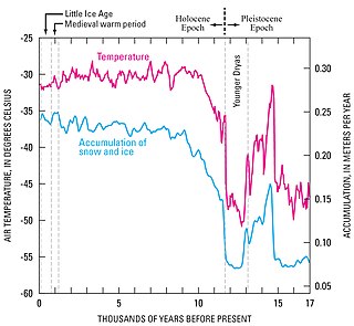
The Younger Dryas was a return to glacial conditions which temporarily reversed the gradual climatic warming after the Last Glacial Maximum started receding around 20,000 BP. It is named after an indicator genus, the alpine-tundra wildflower Dryas octopetala, as its leaves are occasionally abundant in the Late Glacial, often minerogenic-rich, like the lake sediments of Scandinavian lakes.

As the trend in the Earth Impact Database for about 26 confirmed craters younger than a million years old show that almost all are less than two km (1.2 mi) in diameter (except the three km (1.9 mi) Agoudal and four km (2.5 mi) Rio Cuarto), the suggestion that two large craters, Mahuika (20 km (12 mi)) and Burckle (30 km (19 mi)), formed just within the last few millennia has been met with skepticism. [135] [136] [137]

Mahuika crater is a submarine feature that is hypothesized to be an impact crater. It is about 20 ± 2 km wide and over 153 meters (502 ft) deep and lies on the New Zealand continental shelf at 48.3 South and 166.4 East, to the south of The Snares. The Mahuika crater is named after the Māori god of fire. However, there is debate about its origins.

However, the source of the young (less than a million years old) and enormous Australasian strewnfield (c. 790 ka) is suggested to be a crater about 100 km (62 mi) across somewhere in Indochina, [138] [139] with Hartung and Koeberl (1994) proposing the elongated 100 km × 35 km (62 mi × 22 mi) Tonlé Sap lake in Cambodia (visible in the map at the side) as a suspect structure. [140]

Aorounga South. Aorounga Central is above this structure Aorounga Impact Crater, Chad.jpg
Aorounga South. Aorounga Central is above this structure
Arlit crater Arlit.png
Arlit crater
The Bangui magnetic anomaly in central Africa Bangui anomaly.JPG
The Bangui magnetic anomaly in central Africa
Decorah crater USGS Decorah crater.jpg
Decorah crater
Duolun crater Duolon crater.png
Duolun crater
El Baz crater El-Baz.png
El Baz crater
Lake Iro Lake Iro.jpg
Lake Iro
Kebira Crater Kebira Crater.jpg
Kebira Crater
Panther Mountain Panther rosette stream pattern.gif
Panther Mountain
Ramgarh crater Ramgarh Crater.JPG
Ramgarh crater
Rubielos de la Cerida Rubielos de la Cerida impact structure-karte topo.jpg
Rubielos de la Cérida
The Nastapoka (Hudson Bay) arc of Quebec (in red). Quebec, Canada.svg
The Nastapoka (Hudson Bay) arc of Quebec (in red).
Silverpit crater in false colours Silverpit northwest perspective.jpg
Silverpit crater in false colours
Sudan (Mahas) crater Mahas crater.png
Sudan (Mahas) crater
Sudan adm location map.svg
Red pog.svg
Mahas
Red pog.svg
Bayuda
Red pog.svg
Red Sea Hills
Ust-Kara and Kara twin? crater Kara crateri crater Russia lansat 7 image.gif
Ust-Kara and Kara twin? crater
Velingara circular structure Velingara ring-structur in senegal.png
Vélingara circular structure
1973 Skylab image of the Vichada Structure Vichada Structure Skylab G40B091120000.jpg
1973 Skylab image of the Vichada Structure
Weaubleau structure Weaubleau Structure shaded relief.jpg
Weaubleau structure
Wembo-Nyama ring structure DR Congo crater.png
Wembo-Nyama ring structure
Wilkes Land crater in Antarctica Antarctica Map Wilkes L Crater.png
Wilkes Land crater in Antarctica

The Decorah crater has been conjectured as being part of the Ordovician meteor event. [141]

Several twin impacts have been proposed such as the Rubielos de la Cérida and Azuara (30–40 Ma), [142] Cerro Jarau and Piratininga (c. 117 Ma), [47] and Warburton East and West (300–360 Ma). [124] However, adjacent craters may not necessarily have formed at the same time such as case of the confirmed Clearwater East and West lakes.

Some confirmed impacts like Sudbury or Chicxulub are also sources of magnetic anomalies [143] and/or gravity anomalies. The magnetic anomalies Bangui and Jackpine Creek, [73] the gravity anomalies Wilkes Land crater and Falkland Islands, [55] and others have been considered as being of impact origin. Bangui apparently has been discredited, [31] [144] but appears again in a 2014 table of unconfirmed structures in Africa by Reimold and Koeberl. [5]

Several anomalies in Williston Basin were identified by Swatzky in the 1970s as astroblemes including Viewfield, Red Wing Creek, Eagle Butte, Dumas, and Hartney, of which only the last two are unconfirmed. [51]

The Eltanin impact has been confirmed (via an iridium anomaly and meteoritic material from ocean cores) but, as it fell into the Pacific Ocean, apparently no crater was formed. The age of Silverpit and the confirmed Boltysh crater (65.17 ± 0.64 Ma), as well as their latitude, has led to the speculative hypothesis that there may have been several impacts during the KT boundary. [145] [146] Of the five oceans in descending order by area, namely the Pacific, Atlantic, Indian, Antarctic, and Arctic, only the smallest (the Arctic) does not yet have a proposed unconfirmed impact crater.

Craters larger than 100 km in the Phanerozoic (after 541 Ma) are notable for their size as well as for the possible coeval events associated with them especially the major extinction events.

For example, the Ishim impact structure [71] is conjectured to be bounded by the late Ordivician-early Silurian (c. 445 ± 5 Ma), [72] the two Warburton basins has been linked to the Late Devonian extinction (c. 360 Ma), [125] both Bedout and the Wilkes Land crater have been associated with the severe Permian–Triassic extinction event (c. 252 Ma), [147] [148] Manicouagan (c. 215 Ma) was once thought to be connected to the Triassic–Jurassic extinction event (c. 201 Ma) [149] but more recent dating has made it unlikely, while the consensus is the Chicxulub impact caused the one for Cretaceous–Paleogene (c. 66 Ma).

However, other extinction theories employ coeval periods of massive volcanism such as the Siberian Traps.

Undiscovered but inferred

Australasian strewnfield. Shaded areas represent tektite finds. Australasian strewnfield.jpg
Australasian strewnfield. Shaded areas represent tektite finds.

There is geological evidence for impact events having taken place on Earth on certain specific occasions, which should have formed craters, but for which no impact craters have been found. In some cases this is because of erosion and Earth's crust having been recycled through plate tectonics, in others likely because exploration of the Earth's surface is incomplete. Typically the ages are already known and the diameters can be estimated.

Parent crater ofExpected crater diameter (km)Age
Dakhleh glass [150] [151] 0.4 km150 ka
Argentinian tektites [152] 5 km480 ka
Australasian tektites [139] 32–114 km780 ka
Central American tektites [153] [154] 14 km820 ka
Skye ejecta deposits [155] Unknown60 Ma
Stac Fada Member 40 km1.2 Ga
Barberton Greenstone Belt microtektites [156] 500 km3.2 Ga
Marble Bar impact spherules [157] "hundreds of kilometers"3.4 Ga

Mistaken identity

Some geological processes can result in circular or near-circular features that may be mistaken for impact craters. Some examples are calderas, maars, sinkholes, glacial cirques, igneous intrusions, ring dikes, salt domes, geologic domes, ventifacts, tuff rings, forest rings , and others. Conversely, an impact crater may originally be thought as one of these geological features, like Meteor Crater (as a maar) or Upheaval Dome (as a salt dome).

The presence of shock metamorphism and shatter cones are important criteria in favor of an impact interpretation, though massive landslides (such as the Köfels landslide of 7800 BC which was once thought to be impact-related) may produce shock-like fused rocks called "frictionite". [158]

See also

Related Research Articles

Impact crater Circular depression on a solid astronomical body formed by a hypervelocity impact of a smaller object

An impact crater is an approximately circular depression in the surface of a planet, moon, or other solid body in the Solar System or elsewhere, formed by the hypervelocity impact of a smaller body. In contrast to volcanic craters, which result from explosion or internal collapse, impact craters typically have raised rims and floors that are lower in elevation than the surrounding terrain. Impact craters range from small, simple, bowl-shaped depressions to large, complex, multi-ringed impact basins. Meteor Crater is a well-known example of a small impact crater on Earth.

Aorounga crater geographical object

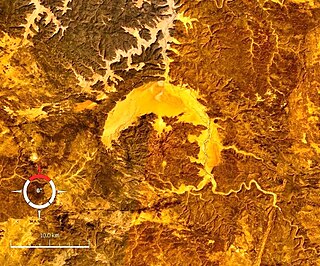
Aorounga is an eroded meteorite impact crater in Chad, Africa. The exposed remnant of the crater is 12.6 km (7.8 mi) in diameter and its age is estimated to be less than 345 million years.

Arkenu structures mountain

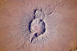
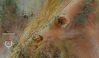
The Arkenu structures, also known as the Arkenu craters, are a pair of prominent circular geological structures. These structures are 10 km and 6.8 km in diameter, and lie about 70 km west of Jabal Arkanu on the eastern margin of the al-Kufrah Basin.

Connolly Basin crater

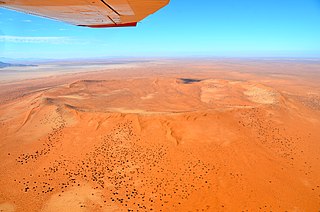
Connolly Basin is a 9 km-diameter impact crater located in the Gibson Desert of central Western Australia. It lies adjacent to the Talawana Track 45 km west of the junction with the Gary Highway, but is difficult to access due to the remoteness of the area. It was originally thought to be a diapir ; an impact origin was first proposed in 1985.,

Gweni-Fada crater impact crater

Gweni-Fada is a meteorite crater in Chad, Africa.

Mount Toondina crater

Mount Toondina crater is an impact structure, the eroded remnant of a former impact crater, situated in northern South Australia 45 km south of the township of Oodnadatta. Mount Toondina is the high point of a circular topographic feature rising out of an otherwise relatively flat desert area of the Eromanga Basin. An impact origin was first suggested in 1976, challenging the earlier diapir hypothesis, and strongly supported by subsequent studies. A geophysical survey using gravity methods indicates an internal structure typical of complex impact craters, including an uplifted centre, and suggests that the original crater was about 3–4 km in diameter. The crater must be younger than the Early Cretaceous age of the rocks in which it is situated, but otherwise is not well dated. It has clearly undergone significant erosion since the impact event.

Rochechouart crater large astrobleme in France, remain of Mesozoic Era impact

The Rochechouart crater is an impact crater. The initial crater morphology has been lost by erosion and there is no crater visible on site. The proper term to designate what remains of the Rochechouart impact crater is Rochechouart impact structure. The term “astrobleme” introduced by R. Dietz since 1947 together with shatter cones as a symptomatic finger print for identifying an eroded impact crater on Earth, is also used to designate the Rochechouart impact structure. In 2008 the French State acknowledged the heritage value of the Rochechouart impact creating the “Réserve Naturelle Nationale de l’astroblème de Rochechouart-Chassenon” on 12 sites representative of characteristics geological features of the impact structure.

Roter Kamm crater mountain in Namibia

Roter Kamm is a meteorite crater, located in the Sperrgebiet, within the Namibian section of the Namib Desert, approximately 80 kilometres (50 mi) north of Oranjemund and 12 kilometres (7.5 mi) southwest of Aurus Mountain in the ǁKaras Region. The crater is 2.5 kilometres (1.6 mi) in diameter and is 130 metres (430 ft) deep. The age is estimated at 4.81 ± 0.5 Ma, placing it in the Pliocene. The crater is exposed at the surface, but its original floor is covered by sand deposits at least 100 metres (330 ft) thick.

Tookoonooka crater impact crater

Tookoonooka is a large meteorite impact crater (astrobleme) situated in South West Queensland, Australia. It lies deeply buried within Mesozoic sedimentary rocks of the Eromanga Basin and is not visible at the surface.

Woodleigh crater impact crater

Woodleigh is a large meteorite impact crater (astrobleme) in Western Australia, centred on Woodleigh Station east of Shark Bay, Gascoyne region. A team of four scientists at the Geological Survey of Western Australia and the Australian National University, led by Arthur J. Mory, announced the discovery in the 15 April 2000 issue of Earth and Planetary Science Letters.

The term cryptoexplosion structure means an explosion of unknown cause. The term is now largely obsolete. It was once commonly used to describe sites where there was geological evidence of a large-scale explosion within the Earth's crust, but no definitive evidence for the cause such as normal volcanic rocks. These sites are usually circular with signs of anomalous rock deformation contrasting with the surrounding region, and often showing evidence that crustal material had been uplifted and/or blown outwards. The assumption was that some unusual form of volcanism, or a gas explosion originating within the crust, was the cause. The use of the term went away with the rise of the science of impact crater recognition in the late 20th century. Most structures described as cryptoexplosions turned out to be eroded impact craters, caused by the impact of meteorites. Today geologists discount former cryptoexplosion theories.

Serra da Cangalha

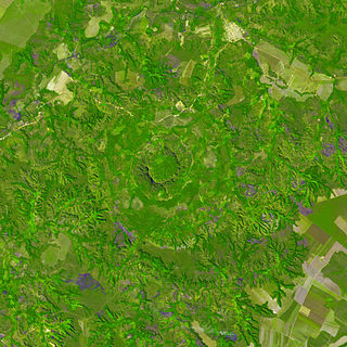
Serra da Cangalha is an impact crater in the State of Tocantins, near the border of Maranhão State, in north/northeastern Brazil. The crater is between 12 and 13 kilometres in diameter, making it the second-largest known crater in Brazil. Its age is estimated to be about 220 million years. The name means Pack-Saddle Mountains in Portuguese.

Australasian strewnfield

The Australasian strewnfield is the youngest and largest of the tektite strewnfields, with recent estimates suggesting it may cover 10%-30% of the Earth's surface.

Impact structure

An impact structure is a generally circular or craterlike geologic structure of deformed bedrock or sediment produced by impact on a planetary surface whatever the stage of erosion of the structure. In contrast an impact crater is the surface expression of an impact structure. In many case, in many cases on Earth, the impact crater has been destroyed by erosion leaving only the deformed rock or sediment of the impact structure behind. This is the fate of almost all old impact craters on Earth, unlike the ancient pristine craters preserved on the Moon and other geologically inactive rocky bodies with old surfaces. in the Solar System. Impact structure is synonymous with the less commonly used term astrobleme meaning "star wound".

Mars may contain ores that would be very useful to potential colonists. The abundance of volcanic features together with widespread cratering are strong evidence for a variety of ores. While nothing may be found on Mars that would justify the high cost of transport to Earth, the more ores that future colonists can obtain from Mars, the easier it would be to build colonies there.

Late Heavy Bombardment Interval when a disproportionately large number of asteroids are theorised to have collided with the inner planets

The Late Heavy Bombardment is an event thought to have occurred approximately 4.1 to 3.8 billion years (Ga) ago, at a time corresponding to the Neohadean and Eoarchean eras on Earth. During this interval, a disproportionately large number of asteroids are theorized to have collided with the early terrestrial planets in the inner Solar System, including Mercury, Venus, Earth, and Mars.

Noachian Era of Mars history

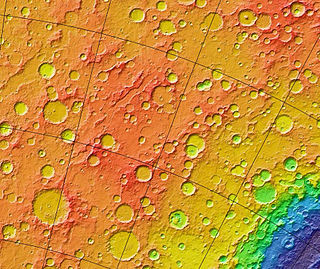
The Noachian is a geologic system and early time period on the planet Mars characterized by high rates of meteorite and asteroid impacts and the possible presence of abundant surface water. The absolute age of the Noachian period is uncertain but probably corresponds to the lunar Pre-Nectarian to Early Imbrian periods of 4100 to 3700 million years ago, during the interval known as the Late Heavy Bombardment. Many of the large impact basins on the Moon and Mars formed at this time. The Noachian Period is roughly equivalent to the Earth’s Hadean and early Archean eons when the first life forms likely arose.

Lakes on Mars

In summer 1965, the first close-up images from Mars showed a cratered desert with no signs of water. However, over the decades, as more parts of the planet were imaged with better cameras on more sophisticated satellites, Mars showed evidence of past river valleys, lakes, and present ice in glaciers and in the ground. It was discovered that the climate of Mars displays huge changes over geologic time because its axis is not stabilized by a large moon, as Earth's is. Also, some researchers maintain that surface liquid water could have existed for periods of time due to geothermal effects or asteroid impacts. This article describes some of the places that could have held large lakes.

References

  1. Impact Field Studies Group
  2. Expert Database on Earth Impact Structures
  3. Earth Impact Database
  4. P. W. Haines (2005). Impact cratering and distal ejecta: the Australian record, Australian Journal of Earth Sciences, v. 52, p. 481–507.
  5. 1 2 3 4 5 W. Reimold & C. Koeberl (2014). Impact structures in Africa: A review, Journal of African Earth Sciences, Volume 93, May 2014, Pages 57–175.
  6. R. Acevedo, M. C. Rocca, J. Ponce, S. Stinco (2015). Impact Craters in South America, Springer, Apr 25, 2015.
  7. M. C. Chabou (2016). An updated inventory of meteorite impact structures in the Arab world, 1st ArabGU International Conference, Feb 2016, Algeria
  8. A. Crósta and U. Reimold (2016). A Book Review: "Impact Craters in South America, by R. D. Acevedo et al."
  9. Meteorite crater site of Ak-Bura
  10. Bacharev, A (1952), The Murgab meteorite crater. Astron. Tsirk., No 122, p.8-10
  11. 1 2 3 4 5 6 7 8 9 10 11 12 13 14 15 Expert Database on Earth Impact Structures (EDEIS), Accessed May 2016
  12. J. B. Garvin and J. J. Frawley (2008). Geometric Properties Of The Merewether Structure, Newfoundland, Canada.Lunar and Planetary Science XXXIX (2008)
  13. V. Feldman, A. Kiselev (2008). Shock-melted impactites at the Svetloyar meteorite crater Volga area, Russia, Lunar and Planetary Science XXXIX
  14. 1 2 R. V. Karanth, P. Thakker, and M. Gadhavi 2006. A preliminary report on the possible impact crater of Kachchh, Current Science, vol. 91, no. 7, October 2006
  15. 1 2 Dietrich, V. J; Lagios, E; Reusser, E; Sakkas, V; Gartzos, E; Kyriakopoulos, K (2013). "The enigmatic Zerelia twin-lakes (Thessaly, Central Greece): two potential meteorite impact Craters". Solid Earth Discussions. 5 (2): 1511–1573. Bibcode:2013SolED...5.1511D. doi:10.5194/sed-5-1511-2013.
  16. L. L. Kashkarov, D. D. Badjukov, A. I. Ivliev, G. V. Kalinina, and M. A. Nazarov, Vernadsky (2005). The Smerdyacheye Lake: New Evidence For Impact Origin And Formation Age, Lunar and Planetary Science XXXVI (2005)
  17. Heinrich, P.V. (2003) Possible Meteorite Impact Crater in St. Helena Parish, Louisiana. Search and Discovery Article. no. 50006. American Association of Petroleum Geologist, Tulsa, Oklahoma. Retrieved March 27, 2011.
  18. 1 2 3 4 A. Rossi (2002). Seven Possible New Impact Structures In Western Africa Detected On Aster Imagery, Lunar and Planetary Science XXXIII
  19. Sakamoto, Masao; Gucsik, Arnold; Nishido, Hirotsugu; Ninagawa, Kiyotaka; Okumura, Tasuku; Toyoda, Shin (2010), "Micro Raman spectroscopy of anomalous planar microstructures in quartz from Mt. Oikeyama: Discovery of a probable impact crater in Japan", Meteoritics and Planetary Science, doi:10.1111/j.1945-5100.2009.01003.x
  20. Cannon, P.J. (1977) Meteorite impact crater discovered in central alaska with landsat imagery, Science, 1977 Jun 17;196(4296):1322-4.
  21. Ned Rozell (2008) The mystery of mammoth tusks with iron fillings
  22. Jonathan T. Hagstrum, Richard B. Firestone, Allen West, Zsolt Stefanka and Zsolt Revay(2010). Micrometeorite Impacts in Beringian Mammoth Tusks and a Bison Skull
  23. 1 2 Harris, R. S.; Schultz, P. H.; Zárate, M. A. (2007) La Dulce Crater: Evidence For A 2.8 Km Impact Structure In The Eastern Pampas Of Argentina, 38th Lunar and Planetary Science Conference
  24. R. D. Acevedo, J. Rabassa, M. J. Orgeira, et al. (2010) Bajada Del Diablo Impact Crater Strewn-Field, Patagonia, Argentina: The Largest Crater Field In The World? 73rd Annual Meteoritical Society Meeting
  25. Acevedo, R. D.; Rabassa, J.; Ponce, J. F, et al. (2012) The Bajada del Diablo astrobleme-strewn field, central Patagonia Argentina: Extending the exploration to surrounding areas Geomorphology, Volume 169, p. 151-164.
  26. 1 2 Garvin, J. B. & Blodget, H. W. (1986). Suspected Impact Crater Near Al Madafi, Saudi Arabia, Meteoritics, Vol. 21, p.366
  27. 1 2 Roger Weller. Al Madafi crater
  28. Henry Brean (2015). New study ranks Nevada crater among world's largest, Las Vegas Review Journal
  29. Roger Weller Anefis crater
  30. Ocampo, A. & Pope, K. (1996). Shuttle Imaging Radar (SIR-C) Images Reveal Multiple Impact Craters at Aorounga, Northern Chad, Lunar and Planetary Science, volume 27, page 977.
  31. 1 2 3 S. Master & W. Reimold (2000). The impact cratering record of Africa: An updated inventory of proven, probable, possible, and discredited impact structures on the African continent, Catastrophic Events Conference 2000.
  32. Zeilik, B. (1987). The Arganaty cosmogenic crater in southern Kazakhstan and the ring structures associated with it. Akademiia Nauk SSSR, Doklady, vol. 297, no. 4, 1987, p. 925-928.
  33. M. Barash (2012). Mass Extinction of Ocean Organisms at the Paleozoic–Mesozoic Boundary: Effects and Causes. Oceanology, 2012, Vol. 52, No. 2, pp. 238–248.
  34. David Rajmon (2010). Impact Field Studies Group
  35. Marc Fokker (2008). Astroforum Netherlands
  36. M. C. Rocca (2005). BAJO HONDO, CHUBUT, PATAGONIA, ARGENTINA: A NEW METEORITE IMPACT CRATER IN BASALT?, 68th Annual Meteoritical Society Meeting
  37. Girdler, R.; Taylor, P.; Frawley, J. (1992). A possible impact origin for the Bangui magnetic anomaly (Central Africa). Tectonophysics, Volume 212, Issue 1, p. 45-58
  38. S. Master, G.R.J. Cooper and K. Klajnik (2013). The Bateke Plateau Structure – A New Possible 7 Km Diameter Quaternary Meteorite Impact Structure In Gabon: A Remote Sensing Study, 13th SAGA Biennial Conference & Exhibition
  39. R. A. Graham (2005) Reinvestigation of the Bee Bluff Structure South of Uvalde, Texas, 'The Uvalde Crater'. Lunar and Planetary Science XXXVI (2005)
  40. H. Henkel, A. Bäckström, B. Bergman, O. Stephansson, and M. Lindström (2005). Geothermal Energy from Impact Craters? The Björkö Study, Proceedings World Geothermal Congress 2005
  41. M. Papagiannis (1989). Photographs from geostationary satellites indicate the possible existence of a huge 300 KM impact crater in the Bohemian region of Czechoslovakia, Meteoritics, Vol. 24, p.313.
  42. P. Rajlich (1992). Bohemian Circular Structure, Czechoslovakia: Search for the Impact Evidence, International Conference on Large Meteorite Impacts and Planetary Evolution. Held 1992, in Sudbury, Canada
  43. Paul Rincon (2006). Space impact clue in Antarctica, BBC News
  44. 1 2 L. P. Hrjanina (Khryanina), 2006. "Once again about Kainozoic meteorite structures in the Ross Sea, Antarctica" (PDF).
  45. Gerard-Little, P., Abbott, D., Breger, D. and Burckle, L (2006). "Evidence for a Possible Late Pliocene Impact in the Ross Sea, Antarctica".CS1 maint: Uses authors parameter (link)
  46. Mark R. Legg, Craig Nicholson, Chris Goldfinger, Randall Milstein, and Marc Kamerling (2004). Large enigmatic crater structures offshore southern California, Geophys. J. Int. (2004) 159, 803–815
  47. 1 2 3 4 A. Crósta, R. Romano (2004). Brazilian Impact Craters: A Review, 35th Lunar and Planetary Science Conference (2004)
  48. 1 2 3 4 A. Crósta, M. Vasconcelos (2013). Update On The Current Knowledge Of The Brazilian Impact Craters, 44th Lunar and Planetary Science Conference (2013)
  49. Vastag, Brian (18 February 2013). "Crater found in Iowa points to asteroid break-up 470 million years ago". Washington Post . Retrieved 19 February 2013.
  50. "Geological survey: Ancient meteorite crater sits below Decorah". Cedar Rapids Gazette . 5 March 2013. Retrieved 6 March 2013.
  51. 1 2 3 Gubins, A. & Strangway, D. (1978). Magnetic Fields Associated with a Probable Late Cretaceous Astrobleme at Dumas, Saskatchewan, LUNAR AND PLANETARY SCIENCE IX, PP. 433–435
  52. Wu Siben (1989). (1989). "Geologic feature of the Duolun impact crater". Lunar and Planetary Science Conference. 20: 1219. Bibcode:1989LPI....20.1219W.
  53. El-Baz, F. (1981). Science, 213, 439–440.
  54. M. Schmieder and E. Buchner (2010). The Faya Basin (Chad) revisited – structural insights from central peak morphology and potential Martian analogs, Nördlingen Ries Crater Workshop (2010).
  55. 1 2 M. Rocca and J. Presser (2015) A possible new very large impact structure in Malvinas Islands, Historia Natural, Tercera Series, Volumen 5(2), 2015.
  56. Acevedo, R. D.; Rocca, M. C. L.; Ponce, J.; Stinco, S. G. (2015). Impact Craters in South America. Springer. p. 23. ISBN   978-3-319-13093-4.
  57. Maximiliano C.L. Rocca et al. (2017). (2017). "Geophysical evidence for a large impact structure on the Falkland (Malvinas) Plateau". Terra Nova. 29 (4): 233–237. doi:10.1111/ter.12269.
  58. Hannah Osborne (May 5, 2017). "Crater Potentially Linked to the Biggest Mass Extinction Event in Earth's History is Discovered". Newsweek Tech & Science.
  59. Amos, J (2009) 'Fried Egg' may be impact crater BBC News.
  60. Roger Weller. Garet El Lefet crater
  61. 1 2 J. Classen (1977). Catalogue of 230 certain, probable, possible, and doubtful impact structures, Meteoritics, vol. 12, Mar. 31, 1977, p. 61-78.
  62. R. D. Acevedo, M. Rocca, J. Rabassa and J. F. Ponce (2011) Meteorite Impact Craters In South America: A Brief Review. 74th Annual Meteoritical Society Meeting (2011)
  63. R. Iaskty and A. Glikson (2005). "Gnargoo: a possible 75 km-diameter post-Early Permian – pre-Cretaceous buried impact structure, Carnarvon Basin, Western Australia", Australian Journal of Earth Sciences, Vol 52, 2005
  64. Kjær, Kurt H.; et al. (2018). "A large impact crater beneath Hiawatha Glacier in northwest Greenland". Science Advances. 4 (11): eaar8173. doi:10.1126/sciadv.aar8173. PMC   6235527 . PMID   30443592.
  65. C. Anderson (1980). A Seismic Reflection Study of a Probable Astrobleme near Hartney, Manitoba
  66. J. Glidewell (2009). SEISMIC DATA THROUGH THE HICO STRUCTURE: A POSSIBLE IMPACT FEATURE IN NORTHCENTRAL TEXAS, 40th Lunar and Planetary Science Conference
  67. M. Mazur and R. Stewart (1998). Interpreting the Hotchkiss structure: A possible meteorite impact feature in northwestern Alberta, Consortium for Research in Elastic Wave Exploration Seismology (CREWES).
  68. B. Deane, P. Lee, K. Milam, J. Evenick, and R.Zawislak (2004). THE HOWELL STRUCTURE, LINCOLN COUNTY, TENNESSEE: A REVIEW OF PAST AND CURRENT RESEARCH, Lunar and Planetary Science XXXV
  69. Milam, K. A., Henderson, T., Deane, B. (2014). An Assessment Of Shock Metamorphism In Breccias From The Howell Structure, Lincoln County, Tennessee, USA, Abstracts of the 2014 GSA Annual Meeting, Geological Society of America
  70. E. Ghoneim (2009). Ibn-Batutah: A possible simple impact structure in southeastern Libya, a remote sensing study, Geomorphology, Volume 103, Issue 3, p. 341-350.
  71. 1 2 Frank Dachille (1976). (1976). "Frequency of the formation of large terrestrial impact craters". Meteoritics. 11: 270. Bibcode:1976Metic..11..270D.
  72. 1 2 Zeylik B. S.; Seytmuratova E. Yu, 1974: A meteorite-impact structure in central Kazakhstan and its magmatic-ore controlling role. Doklady Akademii Nauk SSSR: 1, Pages 167–170
  73. 1 2 S. Goussev, R. Charters, J. Peirce and W. Glenn (2002). Jackpine Creek Magnetic Anomaly: A Case of the HRAM Prospect Scale Interpretation. CSEG: The Canadian Society of Exploration Geophysicists
  74. Martin Schmieder, Elmar Buchner, & Daniel Paul Le Heron (2009). The Jebel Hadid structure (Al Kufrah Basin, SE Libya)—A possible impact structure and potential hydrocarbon trap?, Marine and Petroleum Geology , Volume 26, Issue 3, March 2009, Pages 310–318
  75. Sharad Master, Brad Pitts and Marek Wendorff (2009). Jwaneng South Structure, Botswana: a New 1.3 km Diameter Buried Cenozoic Impact Crater Discovered by Airship-mounted Gravity Gradometer, 11th SAGA Biennial Technical Meeting and Exhibition
  76. M.S. Huber, D.T. King, Jr., L.W. Petruny, and C. Koeberl (2013). REVISITING KILMICHAEL (MISSISSIPPI), A POSSIBLE IMPACT STRUCTURE, 44th Lunar and Planetary Science Conference
  77. T. Marjanac, A. Tomša, Lj. Marjanac, M. Calogovic & S. Fazinic (2015). Krk impact structure ejecta breccia and melt rocks on the islands of Krk and Rab, Croatian Adriatic: A clue on the impact target lithology, Bridging the Gap III (2015)
  78. S. A. Vishnevsky (2007). The Kurai Basin, Altai mountains (Russia): First evidences of impact origin, Lunar and Planetary Science XXXVIII (2007)
  79. Dietz, R. S. & McHone, J. (1974). Impact structures from ERTS imagery, Meteoritics, Vol. 9, p.329
  80. Roger Weller. Labynkyr ring
  81. James B. Garvin (1986). POSSIBLE IMPACT STRUCTURES IN CENTRAL AFRICA
  82. Roger Weller. Tai Hu crater
  83. Wang, K.; Geldsetzer, H. H. J. (1992). "A late Devonian impact event and its association with a possible extinction event on Eastern Gondwana". Lunar and Planetary Inst., International Conference on Large Meteorite Impacts and Planetary Evolution: 77. Bibcode:1992lmip.conf...77W.
  84. B. J. Hamill (2003). The Loch Leven Crater: Anatomy Of A Low-Angle Oblique Impact Structure, Large Meteorite Impacts (2003)
  85. P. Tonkin (1998). Lorne Basin, New South Wales: Evidence for a possible impact origin?, Australian Journal of Earth Sciences, Volume 45, Issue 5, 1998
  86. D. Nisca, H. Thunehed, L.J. Pesonen, S-Å. Elming (1997). The Lycksele structure, a huge ring formation in northern Sweden: result of an impact?, Large Meteorite Impacts and Planetary Evolution
  87. L.J. Pesonen (1996). The Impact Cratering Record of Fennoscandia, Earth, Moon and Planets, Volume 72, Issue 1–3, pp. 377–393
  88. Roger Weller. Madagascar structure
  89. Tamas Bodoky et al. (2007). Is the Magyarmecske telluric conductivity anomaly a buried impact structure?
  90. Garde, Adam A.; McDonald, Iain; Dyck, Brendan; Keulen, Nynke (2012). "Searching for giant, ancient impact structures on Earth: The Mesoarchaean Maniitsoq structure, West Greenland". Earth and Planetary Science Letters. 337–338: 197–210. Bibcode:2012E&PSL.337..197G. doi:10.1016/j.epsl.2012.04.026.
  91. Scherst, Anders; Garde, Adam A. (30 July 2013). "Complete hydrothermal re-equilibration of zircon in the Maniitsoq structure, West Greenland: A 3001 Ma minimum age of impact?". Meteoritics & Planetary Science. 48 (8): 1472–1498. Bibcode:2013M&PS...48.1472S. doi:10.1111/maps.12169.
  92. Roger Weller. Mejaouda crater
  93. A.C. Ocampo, A.C. Garrido, J. Rabassa, M.C. Rocca, J.C. Echaurren, and E. Mazzoni (2005). A Possible Impact Crater In Basalt At Meseta De La Barda Negra, Neuquen, Argentina, 68th Annual Meteoritical Society Meeting
  94. G. Burba (1991). Middle-Urals Ring structure, USSR: Definition, description, possible planetary analogues, Lunar and Planetary Science conference XXII.
  95. G. Burba (2003). The geologic evolution of the Ural Mountains: A supposed exposure to a giant impact. Microsymposium 38, MS011, 2003
  96. S.Genest and F.Robert). [https://www.hou.usra.edu/meetings/metsoc2017/pdf/6047.pdf
  97. A. Glikson, D. Jablonski, & S. Westlake (2010). Origin of the Mt Ashmore structural dome, west Bonaparte Basin, Timor Sea. Australian Journal of Earth Sciences, Volume 57, Issue 4
  98. Examining a new asteroid crater found in the Timor Sea. ScienceWise 2010, Australian National Uni
  99. Elmar Buchner, Martin Schmieder (2007). Mousso structure: a deeply eroded, medium-sized complex impact crater in northern Chad?, Journal of African Earth Sciences 49, 71–78
  100. J. B. Plescia (1999). Mulkarra Impact Structure, South Australia: A Complex Impact Structure, Lunar and Planetary Science XXX
  101. J.M. Comstock and J.R. Morrow (2000). PEERLESS STRUCTURE SOUTHWESTERN DANIELS COUNTY, MONTANA: A PROBABLE MIDORDOVICIAN IMPACT EVENT, Lunar and Planetary Science XXXI
  102. B. Levin, E. Gretskaya, G. Nemchenko (2006). A new astrobleme in the Pacific Ocean, Doklady Earth Sciences, 2006, Vol. 411, No. 8, pp.1336–1338.
  103. W. D. MacDonald, A. P. Crosta, J. Francolin (2006) Structural Dome At São Miguel do Tapuio, Piaui, Brazil, 69th Annual Meteoritical Society Meeting (2006)
  104. Dietz, R. & McHone, J. (1991). Astroblemes Recently Confirmed with Shatter Cones, Abstracts for the 54th Annual Meeting of the Meteoritical Society. Held July 21–26, 1991.
  105. Wu Siben (1988). The Shanghewan Impact Crater, China, Abstracts of the Lunar and Planetary Science Conference, volume 19, page 1296, (1988)
  106. S. A. Vishnevsky (2007). Shiyli Dome, Kazakhstan: Origin Of Central Uplift By Elastic Response, Workshop on Impact Cratering II
  107. Stewart SA, Allen PJ (2002). "A 20-km-diameter multi-ringed impact structure in the North Sea". Nature . 418 (6897): 520–3. Bibcode:2002Natur.418..520S. doi:10.1038/nature00914. PMID   12152076.
  108. A. Sparavigna (2010) Crater-Like Landform in Bayuda Desert (A Processing of Satellite Images)
  109. A. Sparavigna (2010) Craters and ring complexes of the North-East Sudanese country
  110. G. Di Achille (2005). A New Candidate Impact Site In Northeastern Sudan Detected From Remote Sensing, Lunar and Planetary Science XXXVI
  111. Y. Miura (2007) Analyses Of Surface And Underground Data Of Takamatsu Crater In Japan. Lunar and Planetary Science XXXVIII (2007)
  112. Philippe Paillou et al. (2006).An extended field of crater-shaped structures in the Gilf Kebir region, Egypt: Observations and hypotheses about their origin, Journal of African Earth Sciences
  113. Roger Weller. Tarek crater
  114. 1 2 B. W. Levin, S. A. Vishnevsky, and N. A. Palchik (2010). Underwater depressions on the bottom of the Tatarsky Strait, the Sea of Japan (western coast of the Sakhalin Island, Russia): possible marine impact craters, 41st Lunar and Planetary Science Conference (2010)
  115. J. de Menezes, C. de Souza, F. Fortes, and C. Filho (1999). Geophysical Evidence Of A Possible Impact Structure At The K-T Boundary Of The Solimões Basin, Brazil, 6th International Congress of the Brazilian Geophysical Society
  116. K. Bron (2015) The Tookoonooka-Talundilly tsunami sequence: constraining marine impact stratigraphy, Australian School of Petroleum, The University of Adelaide
  117. Roger Weller. Temimichat crater
  118. G. Komatsu et al. (2015)The Tsenkher structure, Gobi-Altai, Mongolia: A probable impact crater with well-preserved rampart ejecta. 46th Lunar and Planetary Science Conference (2015)
  119. "Potential asteroid impact identified in western Queensland". Geoscience Australia. 2015-03-17. Retrieved 26 June 2016.
  120. C. Koeberl (1990). The Kara/Ust-Kara twin impact structure. Geological Society of America, special paper.
  121. S. Wade, M. Barbieri, J. Lichtenegger (2001) The Velingara Circular Structure Esa Bulletin June 2001
  122. Harris, J. B., Jones, D. R., & Street, R. L. (1991). A shallow seismic refraction study of the Versailles cryptoexplosion structure, central Kentucky, Meteoritics, vol. 26, March 1991, p. 47-53
  123. UQ Researcher Discovers Giant Asteroid Impact, University News and Information Service (2010)
  124. 1 2 3 World's largest asteroid impact zone found in Australia: Meteorite broke in two, leaving two craters each 200 km across. Mar 24, 2015
  125. 1 2 3 Stephen Luntz (2013). Huge Asteroid Impact Identified. Australasian Science
  126. G. Monegato; M. Massironi & E. Martellato (2010). "The Ring Structure of Wembo-Nyama (Eastern Kasai, R.D. Congo): A Possible Impact Crater in Central Africa" (PDF). Lunar and Planetary Science. XLI.
  127. "Ring may be giant 'impact crater'". BBC News. 2010-03-10. Retrieved 2010-05-08.
  128. E. F. Albin and R. S. Harris (2016). WOODBURY ASTROBLEME: FURTHER EVIDENCE FOR A LATE PROTEROZOIC IMPACT STRUCTURE IN WEST-CENTRAL GEORGIA, USA, 47th Lunar and Planetary Science Conference
  129. Dentith, M., Bevan, A., Backhouse, J., Featherstone, W., and Koeberl, C. (1999). Yallalie: a Buried Structure of Possible Impact Origin in the Perth Basin, Western Australia. Geological Magazine 136 (6): pp. 619–632.
  130. Grant, B. The Yallalie Impact Structure.
  131. Whitehouse, David (2003-06-23). "Space impact 'saved Christianity'". BBC News. British Broadcasting Corporation . Retrieved 2009-09-10.
  132. Sandra Blakeslee (2006). Ancient Crash, Epic Wave
  133. Master, S. (2002) Umm al Binni lake, a possible Holocene impact structure in the marshes of southern Iraq. In: Leroy, S. and Stewart, I.S. (Eds.), Environmental Catastrophes and Recovery in the Holocene, Abstracts Volume, Brunel University, UK, 29 August – 2 September 2002, pp. 56–57
  134. Stevens, G, I Spooner, J Morrow, P Pufahl, R Raeside, RAF Grieve, CR Stanley, SM Barr, and D McMullin (2008) Physical evidence of a late-glacial (Younger Dryas?) impact event in southwestern Nova Scotia. Atlantic Geology. 44:42.
  135. Goff, James; et al. (2010). "Analysis of the Mahuika comet impact tsunami hypothesis". Marine Geology . 271 (3/4): 292–296. Bibcode:2010MGeol.271..292G. doi:10.1016/j.margeo.2010.02.020.
  136. Bourgeois, J., and R. Weiss (2009) 'Chevrons' are not mega-tsunami deposits; a sedimentologic assessment. Geology. 37(5):403–406.
  137. Pinter, N., and S.E. Ishman, S.E. (2008). Impacts, mega-tsunami, and other extraordinary claims. GSA Today. 18(1):37.
  138. Povenmire H., Liu W. and Xianlin I. (1999) "Australasian tektites found in Guangxi Province, China", 30th Annual Lunar and Planetary Science Conference, Houston, March 1999.
  139. 1 2 Glass B.P. and Pizzuto J.E. (1994) "Geographic variation in Australasian microtektite concentrations: Implications concerning the location and size of the source crater," J of Geophysical Research, vol 99, no E9, 19075-19081, Sept 1994.
  140. Hartung J. and Koberl C. (1994) "In search of the Australasian tektite source crater: the Tonle sap hypothesis", Meteoritics.
  141. Vastag, Brian (18 February 2013). "Crater found in Iowa points to asteroid break-up 470 million years ago". Washington Post . Retrieved 19 February 2013.
  142. Ernstson, K., Claudin, F., Schüssler, U. & Hradil, K. (2002): The mid-Tertiary Azuara and Rubielos de la Cérida paired impact structures (Spain) – Treb. Mus. Geol. Barcelona, 11, 5 – 65.
  143. Magnetic anomaly map, Sudbury, Ontario and Quebec. Natural Resources Canada
  144. L. Antoine, W. Reimold, and A. Tessema (1999) The Bangui Magnetic Anomaly Revisited, 62nd Annual Meteoritical Society Meeting
  145. Howard Falcon-Lang (2010). Double space strike 'caused dinosaur extinction', BBC News
  146. Jolley D., Gilmour I., Gurov E., Kelley S., Watson J. (2010) Two large meteorite impacts at the Cretaceous-Paleogene boundary Geology September 2010, v. 38, pp. 835–838, doi : 10.1130/G31034.1
  147. Becker L., Shukolyukov A., Macassic C., Lugmair G. & Poreda R. 2006. Extraterrestrial Chromium at the Graphite Peak P/Tr boundary and in the Bedout Impact Melt Breccia. Lunar and Planetary Science XXXVII (2006), abstract # 2321.PDF
  148. Gorder, Pam Frost (June 1, 2006). "Big Bang in Antarctica – Killer Crater Found Under Ice". Ohio State University Research News. Archived from the original on March 6, 2016.
  149. Hodych, J.P.; G.R.Dunning (1992). "Did the Manicouagan impact trigger end-of-Triassic mass extinction?". Geology. 20 (1): 51.54. Bibcode:1992Geo....20...51H. doi:10.1130/0091-7613(1992)020<0051:DTMITE>2.3.CO;2.
  150. A. Haldeman et al. (2005). Mapping Impact Modified Sediments: Subtle Remote-Sensing Signatures of the Dakhleh Oasis Catastrophic Event, Western Desert, Egypt, Bulletin of the American Astronomical Society, Vol. 37, p.648
  151. G. Osinski, A. Haldemann, et al. (2007). Impact Glass At The Dakhleh Oasis, Egypt: Evidence For A Cratering Event Or Large Aerial Burst?, Lunar and Planetary Science XXXVIII
  152. P. Bland et al. (2002). A possible tektite strewn field in the Argentinian Pampa, Science, Volume 296, Issue 5570, pp. 1109–1112
  153. H. Povenmire, R. S. Harris, and J. H. Cornec (2011). The New Central American Tektite and Strewn Field. 42nd Lunar and Planetary Science Conference, Houston, Texas. abstract no. 1224.
  154. H. Povenmire, B. Burrer, J. H. Cornec, and R. S. Harris (2012). The New Central American Tektite Strewn Field Update. 43rd Lunar and Planetary Science Conference, Houston, Texas. abstract no. 1260.
  155. Drake, Simon M.; Beard, Andrew D.; Jones, Adrian P.; Brown, David J.; Fortes, A. Dominic; Millar, Ian L.; Carter, Andrew; Baca, Jergus; Downes, Hilary (2017). "Discovery of a meteoritic ejecta layer containing unmelted impactor fragments at the base of Paleocene lavas, Isle of Skye, Scotland". Geology. 46 (2): 171. doi:10.1130/g39452.1.
  156. “Scientists reconstruct ancient impact that dwarfs dinosaur-extinction blast”, American Geophysical Union, April 9, 2014
  157. McKirdy, Euan. "This apocalyptic asteroid's impact was bigger than one that killed dinosaurs". CNN.com. CNN. Retrieved 19 May 2016.
  158. Weidinger JT, Korup O (2008). "Frictionite as evidence for a large Late Quaternary rockslide near Kanchenjunga, Sikkim Himalayas, India — Implications for extreme events in mountain relief destruction". Geomorphology. 103 (1): 57–65. Bibcode:2009Geomo.103...57W. doi:10.1016/j.geomorph.2007.10.021.
  159. Mika McKinnon (2015). This Is Not A Crater, So What Is It? at space.gizmodo.com
  160. Roger Weller. Semsiyat crater
  161. Dietz, R.S., R. Fudali, and W. Cassidy (1969) Richat and Semsiyat Domes (Mauritania): Not Astroblemes. Geological Society of America. v. 80, no. 7, pp. 1367-1372.
Map all coordinates using: OpenStreetMap  
Download coordinates as: KML  ·  GPX