Longswamp, Pennsylvania

Last updated

Longswamp, Pennsylvania
Unincorporated community
Village of Longswamp, PA from southeast (1), May 2024.jpg
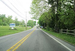
Westbound State Street in Longswamp
USA Pennsylvania location map.svg
Red pog.svg
Longswamp
Coordinates: 40°29′53″N75°39′18″W / 40.49806°N 75.65500°W / 40.49806; -75.65500
Country United States
State Pennsylvania
County Berks
Township Longswamp
Elevation
502 ft (153 m)
Time zone UTC-5 (Eastern (EST))
  Summer (DST) UTC-4 (EDT)
Area code(s) 610 and 484
GNIS feature ID1179926 [1]

Longswamp is an unincorporated community in Longswamp Township in Berks County, Pennsylvania, United States. Longswamp is located along State Street southeast of Topton. [2]

History

A post office called Longswamp was established in 1822, and remained in operation until 1906. [3] The community took its name from Longswamp Township. [4]

Related Research Articles

<span class="mw-page-title-main">Hereford Township, Pennsylvania</span> Township in Pennsylvania, United States

Hereford Township is a township in Berks County, Pennsylvania, United States. It is the easternmost municipality within Berks County. Its population was 2,969 at the 2020 census. It is in Upper Perkiomen School District.

<span class="mw-page-title-main">Longswamp Township, Pennsylvania</span> Township in Pennsylvania, United States

Longswamp Township is a township in Berks County, Pennsylvania, United States. The population was 5,551 at the 2020 census.

<span class="mw-page-title-main">Hereford, Pennsylvania</span> Census-designated place in Pennsylvania, United States

Hereford is a census-designated place that is located in Hereford Township, Berks County, Pennsylvania, United States.

Amityville is an unincorporated community in Berks County, Pennsylvania, United States, near the borough of Pottstown. It is located on Old Swede Road in Amity Township.

Blandon is a census-designated place in Maidencreek Township, Berks County, Pennsylvania, United States. It is located at the junction of Pennsylvania Route 73 and Park Road. As of the 2020 census, the population was 7,289 residents.

Manatawny is an unincorporated community in Berks County, Pennsylvania, United States. It is located at the junction on PA Route 73 and Hoch Road in Oley Township, a short distance from Pleasantville.

<span class="mw-page-title-main">Plowville, Pennsylvania</span> Unincorporated area in Pennsylvania, U.S.

Plowville is an unincorporated area of Robeson Township, Berks County, Pennsylvania, United States. it is located on Pennsylvania Route 10, just east of Interstate 176. Its zip code is 19540 and the community is served by the Twin Valley School District. The most recognizable landmark is Plow Church.

Berne is an unincorporated community in northern Berks County, Pennsylvania, United States. The community is approximately three miles outside Hamburg and is served by the Hamburg Area School District. Berne sits near the Schuylkill River, south of Blue Mountain, in southeastern Tilden Township.

<span class="mw-page-title-main">Joanna, Pennsylvania</span> Unincorporated community in the U.S. state of Pennsylvania

Joanna is an unincorporated community in southern Berks County, Pennsylvania, United States. Joanna sits in southern Robeson Township, near the borough of New Morgan, and is also near Caernarvon Township and near the Pennsylvania Turnpike. The Twin Valley School District serves Joanna; the high school is located close to the village.

<span class="mw-page-title-main">Oley, Pennsylvania</span> Census-designated place in Pennsylvania, United States

Oley, also called Friedensburg, is a census-designated place (CDP) that is located on Routes 73 and 662 in northern Oley Township, Berks County, United States.

<span class="mw-page-title-main">Yellow House, Pennsylvania</span> Unincorporated community in Pennsylvania, United States

Yellow House is a village in eastern Berks County, Pennsylvania, United States, situated at the junction of Routes 562 and 662. It is located in Amity Township and Oley Township. It is drained by the Manatawny Creek into the Schuylkill River. It is split between the Douglassville and Oley post offices, which use the ZIP codes of 19518 and 19547, respectively.

Maxatawny is an unincorporated community and census-designated place located on U.S. Route 222 in Maxatawny Township, Berks County, Pennsylvania, United States, five miles east of Kutztown. It is in the Lehigh watershed and Schaefer Run flows through it to the Little Lehigh Creek. Maxatawny has a post office, with the ZIP code of 19538. Traffic speed on US 222 is reduced to 35 miles-per-hour passing through the village, which borders Lehigh County.

Cacoosing is an unincorporated community in Spring Township in Berks County, Pennsylvania, United States. Cacoosing is located along State Hill Road at the crossing of Cacoosing Creek.

Fredericksville is an unincorporated community in Rockland Township in Berks County, Pennsylvania, United States. Fredericksville is located at the intersection of Fredericksville and Five Points Roads.

Hancock is an unincorporated community in Longswamp Township in Berks County, Pennsylvania, United States. Hancock is located at the intersection of State Street and Park Avenue.

Henningsville is an unincorporated community in Longswamp Township in Berks County, Pennsylvania, United States. Henningsville is located at the intersection of Woodside Avenue and Centennial Road.

Maple Grove is an unincorporated community in Longswamp Township in Berks County, Pennsylvania, United States. Maple Grove is located near the intersection of State Street and Mountain Road.

Moselem is an unincorporated community in Richmond Township in Berks County, Pennsylvania, United States. Moselem is located along Pennsylvania Route 662, east of Maiden Creek.

Pikeville is an unincorporated community in Pike Township in Berks County, Pennsylvania, United States. Pikeville is located near the intersection of Lobachsville Road and Oysterdale Road.

Monocacy Station is an unincorporated community that is located in Amity Township in Berks County, Pennsylvania, United States.

References

  1. "Longswamp". Geographic Names Information System . United States Geological Survey, United States Department of the Interior.
  2. Berks County, Pennsylvania Highway Map (PDF) (Map). PennDOT. 2012. Retrieved August 19, 2013.[ permanent dead link ]
  3. "Berks County". Jim Forte Postal History. Retrieved December 1, 2015.
  4. "Some peculiar post office names in Berks". Reading Eagle. November 27, 1910. p. 11. Retrieved December 2, 2015.