Mapleton, Pennsylvania

Last updated
Mapleton, Pennsylvania
Borough
H.O. Andrews Feed Mill 2.jpg
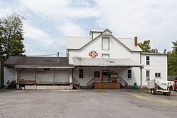
H.O. Andrews Feed Mill on Main Street
Huntingdon County Pennsylvania Incorporated and Unincorporated areas Mapleton Highlighted.svg
Location of Mapleton in Huntingdon County, Pennsylvania.
USA Pennsylvania location map.svg
Red pog.svg
Mapleton
Usa edcp location map.svg
Red pog.svg
Mapleton
Coordinates: 40°23′31″N77°56′25″W / 40.39194°N 77.94028°W / 40.39194; -77.94028
Country United States
State Pennsylvania
County Huntingdon
Government
  TypeBorough Council
  MayorMike Corbin
Area
[1]
  Total0.19 sq mi (0.50 km2)
  Land0.18 sq mi (0.47 km2)
  Water0.01 sq mi (0.02 km2)
Elevation
604 ft (184 m)
Population
 (2020) [2]
  Total418
  Density2,284.15/sq mi (882.32/km2)
Time zone UTC-5 (Eastern (EST))
  Summer (DST) UTC-4 (EDT)
Zip code
17052
Area code 814
FIPS code 42-47248
Website http://www.mapleton-pa.com/index.htm
Local phone exchanges: 542, 543

Mapleton is a borough in Huntingdon County, Pennsylvania, United States. The population was 441 at the 2010 census. [3] It is located on the Juniata River, which is a tributary of the Susquehanna River.

Contents

History

Mapleton was founded when the Pennsylvania Railroad was extended to that point. The community was named for a grove of maple trees near the original town site. [4]

The H.O. Andrews Feed Mill was listed on the National Register of Historic Places in 1990. [5]

Geography

Mapleton is located in east-central Huntingdon County at 40°23′31″N77°56′25″W / 40.39194°N 77.94028°W / 40.39194; -77.94028 (40.392043, -77.940316), [6] on the south bank of the Juniata River at the west entrance of that river's water gap through Jacks Mountain. Pennsylvania Route 655 passes through the center of the borough, leading south 14 miles (23 km) to Saltillo and north 2 miles (3 km) to U.S. Route 22. US 22 leads east 4 miles (6 km) to Mount Union and northwest 8 miles (13 km) to Huntingdon, the county seat.

According to the United States Census Bureau, Mapleton has a total area of 0.19 square miles (0.5 km2), of which 0.01 square miles (0.02 km2), or 4.40%, are water. [3]

Demographics

Historical population
CensusPop.Note
1870 389
1880 44414.1%
1890 71561.0%
1900 612−14.4%
1910 75222.9%
1920 8026.6%
1930 89411.5%
1940 803−10.2%
1950 742−7.6%
1960 666−10.2%
1970 661−0.8%
1980 591−10.6%
1990 529−10.5%
2000 470−11.2%
2010 439−6.6%
2020 418−4.8%
Sources: [7] [8] [9] [2]

As of the census [8] of 2000, there were 473 people, 191 households, and 135 families residing in the borough. The population density was 2,173.1 inhabitants per square mile (839.0/km2). There were 201 housing units at an average density of 923.5 per square mile (356.6/km2). The racial makeup of the borough was 97.67% White, 0.42% African American, 0.21% from other races, and 1.69% from two or more races. Hispanic or Latino of any race were 0.21% of the population.

There were 191 households, out of which 28.3% had children under the age of 18 living with them, 58.1% were married couples living together, 7.9% had a female householder with no husband present, and 28.8% were non-families. 22.0% of all households were made up of individuals, and 12.6% had someone living alone who was 65 years of age or older. The average household size was 2.48 and the average family size was 2.89.

In the borough the population was spread out, with 22.0% under the age of 18, 7.0% from 18 to 24, 28.1% from 25 to 44, 26.2% from 45 to 64, and 16.7% who were 65 years of age or older. The median age was 41 years. For every 100 females there were 88.4 males. For every 100 females age 18 and over, there were 92.2 males.

The median income for a household in the borough was $32,500, and the median income for a family was $38,125. Males had a median income of $35,556 versus $19,286 for females. The per capita income for the borough was $14,431. About 12.6% of families and 15.6% of the population were below the poverty line, including 17.9% of those under age 18 and 9.8% of those age 65 or over.

Related Research Articles

<span class="mw-page-title-main">Hopewell, Bedford County, Pennsylvania</span> Borough in Pennsylvania, United States

Hopewell is a borough in Bedford County, Pennsylvania, United States. The population was 188 at the 2020 census.

<span class="mw-page-title-main">Coalmont, Pennsylvania</span> Borough in Pennsylvania, United States

Coalmont is a borough in Huntingdon County, Pennsylvania, United States. The population was 91 at the 2020 census.

<span class="mw-page-title-main">Dudley, Pennsylvania</span> Borough in Pennsylvania, United States

Dudley is a borough in Huntingdon County, Pennsylvania, United States. The population was 185 at the 2020 census.

<span class="mw-page-title-main">Henderson Township, Huntingdon County, Pennsylvania</span> Township in Pennsylvania, United States

Henderson Township is a township which is located in Huntingdon County, Pennsylvania, United States. The population was 930 at the time of the 2020 census.

<span class="mw-page-title-main">Mill Creek, Pennsylvania</span> Borough in Pennsylvania, United States

Mill Creek is a borough in Huntingdon County, Pennsylvania, United States. The population was 328 at the 2010 census.

<span class="mw-page-title-main">Mount Union, Pennsylvania</span> Borough in Pennsylvania, United States

Mount Union is a borough in Huntingdon County, Pennsylvania, United States, approximately 44 miles (71 km) southeast of Altoona and 12 miles (19 km) southeast of Huntingdon, on the Juniata River. In the vicinity are found bituminous coal, ganister rock, fire clay, and some timber. A major Easter grass factory is located in the northern quadrant of the borough limits; until May 2007, the facility was owned by Bleyer Industries. The population was 2,447 at the 2010 census.

<span class="mw-page-title-main">Orbisonia, Pennsylvania</span> Borough in Pennsylvania, United States

Orbisonia is a borough in Huntingdon County, Pennsylvania, United States. The population was 428 at the 2010 census.

<span class="mw-page-title-main">Penn Township, Huntingdon County, Pennsylvania</span> Township in Pennsylvania, United States

Penn Township is a township in Huntingdon County, Pennsylvania, United States. The population was 1,086 at the 2020 census. The township includes the village of Hesston and the Seven Points Marina of Raystown Lake.

<span class="mw-page-title-main">Petersburg, Pennsylvania</span> Borough in Pennsylvania, United States

Petersburg is a borough in Huntingdon County, Pennsylvania, United States. It was a stop on the former Pennsylvania Railroad Main Line between Tyrone and Huntingdon and the junction point for the Petersburg Branch. The population was 480 at the 2010 census.

<span class="mw-page-title-main">Shade Gap, Pennsylvania</span> Borough in Pennsylvania, United States

Shade Gap is a borough in Huntingdon County, Pennsylvania, United States. The population was 105 at the 2010 census.

<span class="mw-page-title-main">Shirleysburg, Pennsylvania</span> Borough in Pennsylvania, United States

Shirleysburg is a borough in Huntingdon County, Pennsylvania, United States. The population was 150 at the 2010 census.

<span class="mw-page-title-main">Three Springs, Pennsylvania</span> Borough in Pennsylvania, United States

Three Springs is a borough in Huntingdon County, Pennsylvania, United States. The population was 444 at the 2010 census.

<span class="mw-page-title-main">Delaware Township, Juniata County, Pennsylvania</span> Township in Pennsylvania, United States

Delaware Township is a township in Juniata County, Pennsylvania, United States. The population was 1,615 at the 2010 census.

<span class="mw-page-title-main">Mifflin, Pennsylvania</span> Borough in Pennsylvania, United States

Mifflin is a borough in Juniata County, Pennsylvania, United States. The population was 534 at the 2020 census.

<span class="mw-page-title-main">Mifflintown, Pennsylvania</span> Borough in Pennsylvania, United States

Mifflintown is a borough in and the county seat of Juniata County, Pennsylvania, United States. The population was 842 at the 2020 census.

<span class="mw-page-title-main">Milford Township, Juniata County, Pennsylvania</span> Township in Pennsylvania, United States

Milford Township is a township in Juniata County, Pennsylvania, United States. The population was 1,971 at the 2020 census, a decline from the figure of 2,088 tabulated in 2010.

<span class="mw-page-title-main">Port Royal, Pennsylvania</span> Borough in Pennsylvania, United States

Port Royal is a borough in Juniata County, Pennsylvania, United States. The population was 815 at the 2020 census.

<span class="mw-page-title-main">Thompsontown, Pennsylvania</span> Borough in Pennsylvania, United States

Thompsontown is a borough in Juniata County, Pennsylvania, United States. The population was 629 at the 2020 census.

<span class="mw-page-title-main">Turbett Township, Juniata County, Pennsylvania</span> Township in Pennsylvania, United States

Turbett Township is a township in Juniata County, Pennsylvania, United States. The population was 980 at the 2020 census, a decline from the figure of 981 tabulated in 2010.

<span class="mw-page-title-main">Juniata Terrace, Pennsylvania</span> Borough in Pennsylvania, United States

Juniata Terrace, a former company town, is a borough in Mifflin County, Pennsylvania, United States. The population was 567 at the 2020 census.

References

  1. "ArcGIS REST Services Directory". United States Census Bureau. Retrieved October 12, 2022.
  2. 1 2 "Census Population API". United States Census Bureau. Retrieved Oct 12, 2022.
  3. 1 2 "Geographic Identifiers: 2010 Census Summary File 1 (G001): Mapleton borough, Pennsylvania". American Factfinder. U.S. Census Bureau. Retrieved January 22, 2018.
  4. Espenshade, Abraham Howry (1925). Pennsylvania Place Names. Evangelical Press. p. 312. ISBN   978-0-8063-0416-8.
  5. "National Register Information System". National Register of Historic Places . National Park Service. July 9, 2010.
  6. "US Gazetteer files: 2010, 2000, and 1990". United States Census Bureau. 2011-02-12. Retrieved 2011-04-23.
  7. "Census of Population and Housing". U.S. Census Bureau. Retrieved 11 December 2013.
  8. 1 2 "U.S. Census website". United States Census Bureau . Retrieved 2008-01-31.
  9. "Incorporated Places and Minor Civil Divisions Datasets: Subcounty Resident Population Estimates: April 1, 2010 to July 1, 2012". Population Estimates. U.S. Census Bureau. Archived from the original on 11 June 2013. Retrieved 11 December 2013.