Marsh Butte

Last updated
Marsh Butte
 
Marsh Butte.jpg
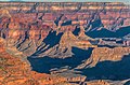
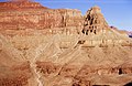
East aspect, from Tonto Trail
Highest point
Elevation 4,721 ft (1,439 m) [1]
Prominence 301 ft (92 m) [1]
Parent peak Diana Temple (6,683 ft) [1]
Isolation 1.51 mi (2.43 km) [1]
Coordinates 36°07′15″N112°14′43″W / 36.1207312°N 112.2451402°W / 36.1207312; -112.2451402 Coordinates: 36°07′15″N112°14′43″W / 36.1207312°N 112.2451402°W / 36.1207312; -112.2451402 [2]
Naming
Etymology Othniel Charles Marsh
Geography
USA Arizona relief location map.svg
Red triangle with thick white border.svg
Marsh Butte
Location in Arizona
Usa edcp relief location map.png
Red triangle with thick white border.svg
Marsh Butte
Marsh Butte (the United States)
Location Grand Canyon National Park
Coconino County, Arizona, US
Parent range Coconino Plateau
Colorado Plateau
Topo map USGS Grand Canyon
Geology
Type of rock limestone, shale, sandstone
Climbing
First ascent 1977
Easiest route class 4 climbing [1]

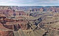
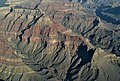
Marsh Butte is a 4,721-foot-elevation (1,439-meter) summit located in the Grand Canyon, in Coconino County in the northern part of the U.S. state of Arizona. [2] It is situated eight miles northwest of Grand Canyon Village, immediately east-northeast of Diana Temple, and Tower of Ra stands directly opposite across Granite Gorge. Topographic relief is significant, as Marsh Butte rises over 2,300 feet (700 meters) above the Colorado River in half a mile (1 km).

Contents

Marsh Butte is composed of Mississippian Redwall Limestone, overlaying the Cambrian Tonto Group, and finally granite of the Paleoproterozoic Vishnu Basement Rocks at river level in Granite Gorge. [3] [4] According to the Köppen climate classification system, Marsh Butte is located in a cold semi-arid climate zone. [5]

History

Marsh Othniel Marsh bust.png
Marsh

In March 1906, this butte was officially named "Endymion Dome", for Endymion of Greek mythology, in keeping with Clarence Dutton's practice of naming geographical features in the Grand Canyon after mythological deities. [2] [6] However, George Wharton James suggested it should be named after preeminent paleontologist Othniel Charles Marsh (1831–1899), and two months later it was officially renamed in May 1906 by the U.S. Board on Geographic Names. [2] George Wharton James described it in his 1910 book "The Grand Canyon of Arizona How to See It" as "a butte of singularly beautiful structure." [7]

The first ascent of the summit was made October 29, 1977, by Pete Baertlein and Mitch McCombs via the class 4 east ridge. [8]

See also

Related Research Articles

<span class="mw-page-title-main">Newton Butte</span> Prominence in the Grand Canyon, Arizona, United States

Newton Butte, in the Grand Canyon, Arizona, United States is a prominence below the South Rim, northwest of Grandview Point, and north on a ridgeline from Shoshone Point which is one mile east of Yaki Point, East Rim Drive. Shoshone Point and Yaki are both on access roads from East Rim Drive, with Yaki being the more advantageous to different viewing directions.

<span class="mw-page-title-main">Zoroaster Temple</span> Landform in Coconino County, Arizona

Zoroaster Temple is a 7,123-foot-elevation (2,171-meter) summit located in the Grand Canyon, in Coconino County of Arizona, USA. It is situated 5.5 miles (8.9 km) northeast of the Yavapai Point overlook on the canyon's South Rim, from which it can be seen towering over 4,600 feet above the Colorado River and Granite Gorge. Its nearest higher neighbor is Brahma Temple, less than one mile to the north-northeast. Zoroaster Temple is named for Zoroaster, an ancient Iranian prophet. This name was used by George Wharton James and Clarence Dutton. Dutton began the tradition of naming geographical features in the Grand Canyon after mythological deities. This geographical feature's name was officially adopted in 1906 by the U.S. Board on Geographic Names.

<span class="mw-page-title-main">Brahma Temple (Grand Canyon)</span> Landform in the Grand Canyon, Arizona

Brahma Temple is a 7,551-foot-elevation summit located in the Grand Canyon, in Coconino County of Arizona, US. It is situated six miles (9.7 km) north-northeast of the Yavapai Point overlook on the canyon's South Rim, and 4.5 miles south of the North Rim's Bright Angel Point. It towers 5,000 feet above Phantom Ranch in Bright Angel Canyon. Its nearest higher neighbor is Oza Butte, four miles to the north-northwest. Other neighbors include Zoroaster Temple one mile to the south, and Deva Temple, 1.5 miles to the north. Brahma Temple is named for Brahma, the Hindu creator of the universe. This name was applied by Clarence Dutton who began the tradition of naming geographical features in the Grand Canyon after mythological deities. This geographical feature's name was officially adopted in 1906 by the U.S. Board on Geographic Names.

<span class="mw-page-title-main">Vishnu Temple (Grand Canyon)</span> Landform in the Grand Canyon, Arizona

Vishnu Temple is a 7,533-foot-elevation (2,296-meter) summit located in the Grand Canyon, in Coconino County of Arizona, US.

<span class="mw-page-title-main">Tower of Set</span> Landform in the Grand Canyon, Arizona

Tower of Set is a 6,012-foot-elevation (1,832-meter) summit located in the Grand Canyon, in Coconino County of Arizona, US. This butte is situated four miles north of Hopi Point overlook on the canyon's South Rim, two miles southeast of Tower of Ra, and three miles south-southwest of Shiva Temple, where it towers 3,600 feet above the Colorado River. Tower of Set was originally named Temple of Sett in 1879 by Thomas Moran, for the Egyptian deity of war, Set, because a niche worn into its wall evoked temples in the valley of the Nile. Another source states it was named by George Wharton James, in keeping with Clarence Dutton's tradition of naming geographical features in the Grand Canyon after mythological deities. This mountain's name was officially adopted in 1906 by the U.S. Board on Geographic Names. In 1919, Harriet Williams Russell Strong proposed connecting Hopi Point and Tower of Set across the river via an aerial tramway, an idea that never came to fruition. The first ascent was made in November 1977 by Bruce Grubbs and Jim Haggart. According to the Köppen climate classification system, Tower of Set is located in a cold semi-arid climate zone.

<span class="mw-page-title-main">Angels Gate</span> Landform in the Grand Canyon, Arizona

Angels Gate is a 6,761-foot (2,061 m)-elevation summit located in the Grand Canyon, in Coconino County of Arizona, United States. It is situated seven miles (11 km) due north of the Grandview Point overlook on the canyon's South Rim, three miles (4.8 km) west of Vishnu Temple, and three point five miles (5.6 km) southeast of Zoroaster Temple. Topographic relief is significant as it rises over 4,200 feet (1,300 m) above the Colorado River in three miles. Angels Gate is the place in Paiute mythology where the gods would return to earth by descending from the shadow world above. George Wharton James applied the "Angel Gate" name to this geographical feature in his book, In & Around the Grand Canyon, in 1900. This feature's name was officially adopted in 1906 by the U.S. Board on Geographic Names. Angels Gate has four peaks composed of Coconino Sandstone. The main highest summit and three spires are known as "Snoopy and his Doghouse" for a resemblance to Snoopy, and the first ascent was made April 1972 by Chuck Graf and Dave Ganci. According to the Köppen climate classification system, Angels Gate is located in a cold semi-arid climate zone.

<span class="mw-page-title-main">Buddha Temple (Grand Canyon)</span> Landform in the Grand Canyon, Arizona

Buddha Temple is a 7,212-foot-elevation (2,198-meter) summit located in the Grand Canyon, in Coconino County of northern Arizona, in the Southwestern United States. It is situated 6.5 miles (10.5 km) due north of the Mather Point overlook on the canyon's South Rim, and four miles southwest of the North Rim's Bright Angel Point. Topographic relief is significant as it rises over 3,800 feet in two miles above Bright Angel Canyon to the east, and 3,000 feet in less than one mile above Haunted Canyon to the immediate west. Its neighbors include Manu Temple 1.5 miles (2.4 km) to the northeast, Isis Temple 2.3 miles to the southwest, Zoroaster Temple 3.8 miles to the southeast, and Deva Temple, 3.5 miles to the east. Buddha Temple was named by Henry Gannett, a geographer for Clarence Dutton, in following Dutton's practice of naming features in the Grand Canyon after mythological deities, in this case Buddha. This geographical feature's name was officially adopted in 1906 by the U.S. Board on Geographic Names. The first ascent of this butte was made in 1973 by Bruce Grubbs, Chauncey Parker, and Mark Brown via the Northwest Arete. According to the Köppen climate classification system, Buddha Temple is located in a Cold semi-arid climate zone.

<span class="mw-page-title-main">Gunther Castle</span> Landform in the Grand Canyon, Arizona

Gunther Castle is a 7,199-foot-elevation (2,194-meter) summit located in the Grand Canyon, in Coconino County of northern Arizona, US. It is situated three miles northwest of Chuar Butte, between Kwagunt Valley to the north, and Chuar Valley to the south. Topographic relief is significant as it rises nearly 4,500 feet above the Colorado River in three miles.

<span class="mw-page-title-main">Steamboat Mountain (Coconino County, Arizona)</span> Landform in the Grand Canyon, Arizona

Steamboat Mountain is a 7,410-foot-elevation (2,260-meter) summit located in the Grand Canyon, in Coconino County of northern Arizona, US. It is situated four miles northwest of Holy Grail Temple, and 2.5 miles west-southwest of Timp Point on the North Rim. George Wharton James described it as a "majestic butte", nearly encircled by Galloway and Saddle Canyons. Topographic relief is significant as it rises over 5,400 feet above the Colorado River in three miles. According to the Köppen climate classification system, Steamboat Mountain is located in a Cold semi-arid climate zone, with precipitation runoff draining west to the Colorado River via Tapeats Creek and Stone Creek. This feature's name was officially adopted in 1932 by the U.S. Board on Geographic Names.

<span class="mw-page-title-main">Pollux Temple</span> Landform in the Grand Canyon, Arizona

Pollux Temple is a 6,251-foot-elevation (1,905-meter) summit in the Grand Canyon, in Coconino County of northern Arizona, US. It is situated ten miles northwest of Grand Canyon Village, and less than one mile northeast of Jicarilla Point. Castor Temple is one mile northwest, and Diana Temple is one mile southeast. Topographic relief is significant as Pollux Temple rises nearly 4,000 feet above the Colorado River in less than two miles. Pollux Temple is named for Pollux, the divine son of Zeus according to Greek mythology. Clarence Dutton began the practice of naming geographical features in the Grand Canyon after mythological deities. According to the Köppen climate classification system, Pollux Temple is located in a Cold semi-arid climate zone.

<span class="mw-page-title-main">Diana Temple (Grand Canyon)</span> Landform in the Grand Canyon, Arizona

Diana Temple is a 6,683-foot-elevation (2,037-meter) summit located in the Grand Canyon, in Coconino County of northern Arizona, US. It is situated nine miles northwest of Grand Canyon Village, and immediately northeast of Mescalero Point. Pollux Temple is one mile northwest, Marsh Butte one mile east-northeast, and Vesta Temple is one mile south. Topographic relief is significant as Diana Temple rises nearly 4,300 feet above the Colorado River in less than two miles. Diana Temple is named for Diana, the goddess of the hunt and the moon according to Roman mythology. Clarence Dutton began the practice of naming geographical features in the Grand Canyon after mythological deities. The U.S. Geological Survey applied the name, and this geographical feature's name was officially adopted in 1908 by the U.S. Board on Geographic Names. In the early 1900s this mesa was sometimes called "No Mans Land". According to the Köppen climate classification system, Diana Temple is located in a Cold semi-arid climate zone.

<span class="mw-page-title-main">Cheops Pyramid</span> Landform in the Grand Canyon, Arizona

Cheops Pyramid is a 5,401-foot-elevation (1,646-meter) summit located in the Grand Canyon, in Coconino County of Arizona, US. This butte is situated four miles north of Grand Canyon Village, 2.5 miles south-southwest of Buddha Temple, and 1.7 mile south-southeast of Isis Temple, which is the nearest higher neighbor. Topographic relief is significant as it rises 3,000 feet above the Colorado River in 1.5 mile. It was named by George Wharton James for the fanciful resemblance to the famous pyramid constructed by Egyptian Pharaoh Cheops. This was in keeping with Clarence Dutton's tradition of naming geographical features in the Grand Canyon after mythological deities. This butte's name was officially adopted in 1906 by the U.S. Board on Geographic Names. According to the Köppen climate classification system, Cheops Pyramid is located in a Cold semi-arid climate zone.

<span class="mw-page-title-main">Geikie Peak</span> Landform in the Grand Canyon, Arizona

Geikie Peak is a 5,005-foot (1,526 m)-elevation summit located in the Grand Canyon, in Coconino County of northern Arizona, United States. It is situated nine miles (14 km) northwest of Grand Canyon Village, immediately north of Diana Temple, and south of Scorpion Ridge which lies across the opposite side of Granite Gorge. Access is via the Tonto Trail which traverses 270 degrees around the base of the peak. Topographic relief is significant as Geikie Peak rises over 2,600 feet (790 m) above the Colorado River in one-half mile (0.80 km). According to the Köppen climate classification system, Geikie Peak is located in a cold semi-arid climate zone.

<span class="mw-page-title-main">O'Neill Butte</span> Landform in the Grand Canyon, Arizona

O'Neill Butte is a 6,071-foot (1,850 m)-elevation summit located in the Grand Canyon, in Coconino County of northern Arizona, United States. It is situated 2.5 miles (4.0 km) east-northeast of Grand Canyon Village, one mile (1.6 km) northeast of Mather Point, and one mile immediately northwest of Yaki Point. Cedar Ridge connects O'Neill Butte with Yaki Point on the South Rim. Topographic relief is significant as O'Neill Butte rises 3,600 feet (1,100 m) above the Colorado River in two miles (3.2 km). Access to this prominence is via the South Kaibab Trail which traverses the east slope of the peak. According to the Köppen climate classification system, O'Neill Butte is located in a cold semi-arid climate zone.

<span class="mw-page-title-main">Newberry Butte</span> Landform in the Grand Canyon, Arizona

Newberry Butte is a 5,105-foot-elevation (1,556-meter) summit located in the Grand Canyon, in Coconino County of northern Arizona, US. It is situated 4.5 miles north of the South Rim's Grandview Point, three miles southwest of Vishnu Temple, and 2.5 miles south of Wotans Throne. Topographic relief is significant as it rises over 2,500 feet above the Colorado River and Granite Gorge in one mile. According to the Köppen climate classification system, Newberry Butte is located in a Cold semi-arid climate zone.

<span class="mw-page-title-main">Butchart Butte</span> Landform in the Grand Canyon, Arizona

Butchart Butte is a 7,602-foot (2,317 m)-elevation summit located in the Grand Canyon, in Coconino County of northern Arizona, United States. It is situated on the North Rim, midway between Gunther Castle and Siegfried Pyre, and between the Chuar and Kwagunt Valleys. Topographic relief is significant as it rises 4,900 feet (1,500 m) above the Colorado River in five miles.

<span class="mw-page-title-main">Vesta Temple</span> Landform in the Grand Canyon, Arizona

Vesta Temple is a 6,299-foot-elevation (1,920-meter) summit located in the Grand Canyon, in Coconino County of northern Arizona, US. It is situated eight miles west-northwest of Grand Canyon Village, and immediately northeast of Mimbreno Point. Marsh Butte is one mile northeast, Eremita Mesa immediately southeast, and nearest higher neighbor Diana Temple is one mile north. Topographic relief is significant as Vesta Temple rises 3,900 feet above the Colorado River in 2.5 miles. Vesta Temple is named for Vesta, the goddess of the hearth, home, and family according to Roman mythology. Clarence Dutton began the practice of naming geographical features in the Grand Canyon after mythological deities. This geographical feature's name was officially adopted in 1908 by the U.S. Board on Geographic Names. According to the Köppen climate classification system, Vesta Temple is located in a Cold semi-arid climate zone.

<span class="mw-page-title-main">Lyell Butte</span> Landform in the Grand Canyon, Arizona

Lyell Butte is a 5,362-foot (1,634 m) elevation summit located in the Grand Canyon, in Coconino County of northern Arizona, United States. It is situated six miles (9.7 km) east of Grand Canyon Village, immediately east of and below Shoshone Point, and 1.5 mile southeast of Newton Butte, which is the nearest higher neighbor. Topographic relief is significant as Lyell Butte rises 2,800 feet (850 m) above the Colorado River in 1.5 mile. Access is via the Tonto Trail which traverses the base of the peak. According to the Köppen climate classification system, Lyell Butte is located in a cold semi-arid climate zone, with precipitation runoff draining northeast to the Colorado River via Grapevine and Boulder Creeks.

<span class="mw-page-title-main">Grand Scenic Divide</span> Landform in the Grand Canyon, Arizona

Grand Scenic Divide is a 5,667-foot-elevation (1,727-meter) ridge located in the Grand Canyon, in Coconino County of northern Arizona, Southwestern United States. It is situated immediately north of Fossil Mountain, and 1.5 mile east of Mount Huethawali. Surrounded by Bass and Serpentine Canyons, topographic relief is significant as it rises over 3,400 feet above the nearby Colorado River in 1.5 mile. It is composed of strata of the Pennsylvanian-Permian Supai Group. Further down are strata of the cliff-forming Mississippian Redwall Limestone, and Cambrian Tonto Group. According to the Köppen climate classification system, Grand Scenic Divide is located in a cold semi-arid climate zone. The normal approach to the ridge is made via the South Bass Trail, and from the top the view includes Masonic Temple, Holy Grail Temple, Dox Castle, King Arthur Castle, Evans Butte, Sagittarius Ridge, and Scorpion Ridge.

<span class="mw-page-title-main">Kibbey Butte</span> Landform in the Grand Canyon, Arizona

Kibbey Butte is a 7,801-foot-elevation (2,378-meter) summit located in the Grand Canyon, in Coconino County of northern Arizona, US. It is situated two miles south of the Point Imperial viewpoint on the canyon's North Rim, where it towers over 3,000 feet above Nankoweap Canyon. Its nearest higher neighbor is Brady Peak one mile to the southeast, Hancock Butte is one mile to the north-northeast, and Alsap Butte is two miles to the east. The summit of this butte is composed of dark reddish Permian Hermit Shale overlaying the Pennsylvanian-Permian Supai Group, in turn overlaying the cliff-forming Mississippian Redwall Limestone. According to the Köppen climate classification system, Kibbey Butte is located in a cold semi-arid climate zone. Precipitation runoff from this feature drains east into the Colorado River via Nankoweap Creek. Cross-country access to Kibbey Butte starts at the parking area for Greenland Lake. The first ascent of the summit was made by Harvey Butchart and Allyn Cureton on May 31, 1961.

References

  1. 1 2 3 4 5 "Marsh Butte – 4,721' AZ". Lists of John. Retrieved 2021-01-14.
  2. 1 2 3 4 "Marsh Butte". Geographic Names Information System . United States Geological Survey, United States Department of the Interior . Retrieved 2021-01-14.
  3. N.H. Darton, Story of the Grand Canyon of Arizona, 1917, page 39.
  4. William Kenneth Hamblin, Anatomy of the Grand Canyon: Panoramas of the Canyon's Geology, 2008, Grand Canyon Association Publisher, ISBN   9781934656013.
  5. Peel, M. C.; Finlayson, B. L.; McMahon, T. A. (2007). "Updated world map of the Köppen−Geiger climate classification". Hydrol. Earth Syst. Sci. 11. ISSN   1027-5606.
  6. Randy Moore and Kara Felicia Witt, The Grand Canyon: An Encyclopedia of Geography, History, and Culture, 2018, ABC-CLIO Publisher, page 151.
  7. George Wharton James, The Grand Canyon of Arizona How to See It, 1910, Little Brown and Company, page 40.
  8. Aaron Tomasi, Pernell Tomasi, Grand Canyon Summits Select An Obscure Compilation of Sixty-nine Remote Ascent Routes in the Grand Canyon National Park Backcountry, 2001, ISBN   9780971088009, page 54.