Marshfield Hills, Massachusetts

Last updated

Marshfield Hills, Massachusetts
Highland Street, Marshfield Hills, MA.jpg
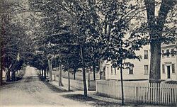
Highland Street c. 1905
Plymouth County Massachusetts incorporated and unincorporated areas Marshfield Hills highlighted.svg
Location in Plymouth County in Massachusetts
Coordinates: 42°8′40″N70°43′47″W / 42.14444°N 70.72972°W / 42.14444; -70.72972
CountryUnited States
State Massachusetts
County Plymouth
Area
[1]
  Total4.94 sq mi (12.78 km2)
  Land4.58 sq mi (11.87 km2)
  Water0.35 sq mi (0.91 km2)
Elevation
128 ft (39 m)
Population
 (2020)
  Total2,491
  Density543.53/sq mi (209.85/km2)
Time zone UTC-5 (Eastern (EST))
  Summer (DST) UTC-4 (EDT)
ZIP code
02051
Area code 781
FIPS code 25-38960
GNIS feature ID0615219
Website www.townofmarshfield.org
Marshfield Hills Historic District
MarshfieldMA MarshfieldHills NorthCommunityChurchAndCemetery.jpg
North Community Church and the adjacent cemetery
USA Massachusetts location map.svg
Red pog.svg
Usa edcp location map.svg
Red pog.svg
LocationBow, Highland, Main, Old Main, Pleasant and Prospect Sts., Glen, Marshfield, Massachusetts
Area134 acres (54 ha)
Architectural styleColonial, Georgian
NRHP reference No. 09001096 [2]
Added to NRHPDecember 18, 2009

Marshfield Hills is a census-designated place (CDP) in the town of Marshfield in Plymouth County, Massachusetts, United States. The population was 2,356 at the 2010 census. [3] The historic center of the village has been designated a historic district and listed on the National Register of Historic Places. [2]

Contents

Geography

Marshfield Hills is located at 42°8′40″N70°43′47″W / 42.14444°N 70.72972°W / 42.14444; -70.72972 (42.144557, -70.729800). [4]

According to the United States Census Bureau, the CDP has a total area of 12.7 km2 (4.9 sq mi), of which 11.7 km2 (4.5 sq mi) is land and 1.0 km2 (0.39 sq mi) (7.94%) is water.

Demographics

Historical population
CensusPop.Note
2020 2,491
U.S. Decennial Census [5]

As of the census [6] of 2000, there were 2,369 people, 841 households, and 687 families residing in the CDP. The population density was 202.4 people /km2 (524 people/sq mi). There were 862 housing units at an average density of 73.6 units /km2 (191 units/sq mi). The racial makeup of the CDP was 98.27% White, 0.34% African American, 0.25% Native American, 0.34% Asian, 0.21% from other races, and 0.59% from two or more races. 0.59% of the population were Hispanic or Latino of any race.

There were 841 households, out of which 39.2% had children under the age of 18 living with them, 73.0% were married couples living together, 6.4% had a female householder with no husband present, and 18.2% were non-families. 15.5% of all households were made up of individuals, and 7.1% had someone living alone who was 65 years of age or older. The average household size was 2.82 and the average family size was 3.16.

In the CDP, the population was spread out, with 26.8% under the age of 18, 5.0% from 18 to 24, 26.4% from 25 to 44, 30.0% from 45 to 64, and 11.8% who were 65 years of age or older. The median age was 41 years. For every 100 females, there were 98.4 males. For every 100 females age 18 and over, there were 94.5 males.

The median income for a household in the CDP was $162,197, and the median income for a family was $189,564. Males had a median income of $98,635 versus $82,225 for females. The per capita income for the CDP was $132,484. 0% of families and 0.3% of the population were below the poverty line, including 6.5% of those under the age of 18 and 14.0% of those 65 and older.

See also

Related Research Articles

<span class="mw-page-title-main">Bliss Corner, Massachusetts</span> Census-designated place in Massachusetts, United States

Bliss Corner is a census-designated place (CDP) in the town of Dartmouth in Bristol County, Massachusetts, United States. The population was 5,280 at the 2010 census.

<span class="mw-page-title-main">Mansfield Center, Massachusetts</span> Census-designated place in Massachusetts, United States

Mansfield Center is a census-designated place (CDP) in the town of Mansfield in Bristol County, Massachusetts, United States. The population was 7,360 at the 2010 census.

<span class="mw-page-title-main">Littleton Common, Massachusetts</span> Census-designated place in Massachusetts, United States

Littleton Common is a census-designated place (CDP) in the town of Littleton in Middlesex County, Massachusetts, United States. The population was 3,065 at the 2020 census, up from 2,789 in 2010.

<span class="mw-page-title-main">Green Harbor-Cedar Crest, Massachusetts</span> Former census-designated place in Massachusetts, United States

Green Harbor-Cedar Crest was a census-designated place (CDP) in the towns of Duxbury and Marshfield in Plymouth County, United States. It included the village of Green Harbor, on the shore of Massachusetts Bay, and the community of Cedar Crest, occupying a hill on the north side of Careswell Street. The population of the CDP was 2,609 at the 2010 census. Prior to the 2020 census the area was split into two CDPs, Green Harbor and Cedar Crest.

<span class="mw-page-title-main">Ocean Bluff-Brant Rock, Massachusetts</span> Census-designated place in Massachusetts, United States

Ocean Bluff-Brant Rock is a census-designated place (CDP) in Plymouth County, Massachusetts, United States, composed of the neighborhoods of Ocean Bluff, Brant Rock, Fieldston, and Rexhame in the town of Marshfield. The population of the CDP was 4,970 at the 2010 census.

<span class="mw-page-title-main">East Douglas, Massachusetts</span> CDP in Massachusetts, United States

East Douglas is a census-designated place (CDP) in the town of Douglas in Worcester County, Massachusetts, United States. The population was 2,557 at the 2010 census.

<span class="mw-page-title-main">Fiskdale, Massachusetts</span> CDP in Sturbridge, Massachusetts, United States

Fiskdale is a census-designated place (CDP) in the town of Sturbridge in Worcester County, Massachusetts, United States. The population was 2,583 at the 2010 census.

<span class="mw-page-title-main">Rice Lake (CDP), Minnesota</span> Census-designated place in Minnesota, US

Rice Lake is a census-designated place (CDP) in La Prairie Township, Clearwater County, Minnesota, United States, near Lower Rice Lake. The population was 235 at the 2010 census. It is located within ZIP code 56621 based in Bagley.

<span class="mw-page-title-main">Erlton-Ellisburg, New Jersey</span> Populated place in Camden County, New Jersey, US

Erlton-Ellisburg was an unincorporated community and census-designated place (CDP) located within Cherry Hill Township, in Camden County, in the U.S. state of New Jersey. As of the 2000 United States Census, the CDP's population was 8,168. The area comprises Erlton and Ellisburg, two neighborhoods in western Cherry Hill. As of the 2010 United States Census, the Erlton-Ellisburg CDP was discontinued and a portion of the old CDP was included in the new Ellisburg CDP.

<span class="mw-page-title-main">Preston-Potter Hollow, New York</span> Census-designated place in New York, United States

Preston-Potter Hollow is a census-designated place (CDP) in Albany County, New York, United States. The population was 366 at the 2010 census.

<span class="mw-page-title-main">Narcissa, Oklahoma</span> CDP in Oklahoma, United States

Narcissa is a census-designated place (CDP) in Ottawa County, Oklahoma, United States. The population was 92 at the time of the 2020 United States census.

<span class="mw-page-title-main">Mount Carmel, South Carolina</span> CDP in South Carolina, United States

Mt. Carmel is a census-designated place (CDP) in McCormick County, South Carolina, United States. The population was 237 at the 2000 census.

<span class="mw-page-title-main">Willington, South Carolina</span> CDP in South Carolina, United States

Willington is a census-designated place (CDP) in McCormick County, South Carolina, United States. The population was 177 at the 2000 census.

<span class="mw-page-title-main">Greenville, Virginia</span> CDP in Virginia, United States

Greenville is a census-designated place (CDP) in Augusta County, Virginia, United States. The population was 887 at the 2020 census. It is part of the Staunton–Waynesboro Micropolitan Statistical Area.

<span class="mw-page-title-main">Chesterfield Court House, Virginia</span> Unincorporated community in Virginia, United States

Chesterfield Court House is an unincorporated community and former census-designated place that is the county seat of Chesterfield County, Virginia, United States. It was a census-designated place (CDP) at the 2000 census, but has not been delineated as a CDP since then. The Chesterfield County Courthouse and Courthouse Square are listed in the National Register of Historic Places. The area is also home of the Chesterfield County Government Complex.

<span class="mw-page-title-main">Stanleytown, Virginia</span> CDP in Virginia, United States

Stanleytown is a census-designated place (CDP) in Henry County, Virginia, United States. The population was 1,422 at the 2010 census. It is part of the Martinsville Micropolitan Statistical Area.

<span class="mw-page-title-main">Max Meadows, Virginia</span> CDP in Virginia, United States

Max Meadows is a census-designated place (CDP) in Wythe County, Virginia, United States. The population was 562 at the 2010 census.

<span class="mw-page-title-main">Potter Lake, Wisconsin</span> CDP in Wisconsin, United States

Potter Lake is a census-designated place (CDP) in the town of East Troy, Walworth County, Wisconsin, United States. The population was 1,117 at the 2020 census.

Homa Hills is a census-designated place (CDP) in Natrona County, Wyoming, United States. It is part of the Casper, Wyoming Metropolitan Statistical Area. The population was 278 at the 2010 census.

<span class="mw-page-title-main">Marshfield (CDP), Massachusetts</span> Census-designated place in Massachusetts, United States

Marshfield is a census-designated place (CDP) in the town of Marshfield in Plymouth County, Massachusetts, United States. The population was 4,335 at the 2010 census.

References

  1. "2020 U.S. Gazetteer Files". United States Census Bureau. Retrieved May 21, 2022.
  2. 1 2 "National Register Information System". National Register of Historic Places . National Park Service. July 9, 2010.
  3. "Profile of General Population and Housing Characteristics: 2010 Demographic Profile Data (DP-1): Marshfield Hills CDP, Massachusetts". United States Census Bureau . Retrieved March 26, 2012.
  4. "US Gazetteer files: 2010, 2000, and 1990". United States Census Bureau. February 12, 2011. Retrieved April 23, 2011.
  5. "Census of Population and Housing". Census.gov. Retrieved June 4, 2016.
  6. "U.S. Census website". United States Census Bureau . Retrieved January 31, 2008.