Morro Solar Group

Last updated
Morro Solar Group
Stratigraphic range: Berriasian-Hauterivian
Salto del Fraile Lima Peru.jpg
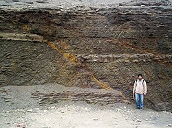
The seaward tilting of the strata of Salto del Fraile Fm. was caused by the Andean orogeny
Type Geological group
Location
Region Lima Province
CountryFlag of Peru.svg  Peru
Type section
Named for Morro Solar

The Morro Solar Group (Spanish : Grupo Morro Solar) is a stratigraphic group of Mesozoic-aged sedimentary formations exposed near Lima, Peru. The groups formations more specifically of Berriasian and Valanginian age (Early Cretaceous) and overlies the Jurassic Puente Piedra Group and underlies the Cretaceous Pamplona Formation. The Morro Solar Group is intruded by sills of andesitic composition. [1] Together with the Casma and Imperial Groups, the Morro Solar Group contains clastic volcanosedimentary material derivative of the Mesozoic Casma Volcanic Arc. [2] The formations of the group hosts mostly local fossils which do not have counterparts for biochronological correlation in other regions. [3]

Stratigraphy

Normal fault in La Herradura Formation, Morro Solar, Peru Falla normal Morro Solar Peru.jpg
Normal fault in La Herradura Formation, Morro Solar, Peru

The formations of the Morro Solar Group are: La Herradura Formation (Spanish: Formación La Herradura), whose sediments reflect a marine near-shore deposition environment, [4] the Valanginian Salto del Fraile Formation (Spanish: Formación Salto del Fraile), and the Marcavilca Formation (Spanish: Formación Marcavilca). [1] The Salto del Fraile Formation is equivalent to the basal part of the Huancané Formation found further inland. [5]

Related Research Articles

Chorrillos District District in Lima, Peru

Chorrillos is a district of the Lima Province in Peru and part of the city of Lima. It gets its name from the Spanish word for "trickle of water". The district was founded as San Pedro de los Chorrillos and served as a deluxe beach resort until the late 19th century, when it was almost completely destroyed by Chilean forces during the War of the Pacific.

Cerro Sechín

Cerro Sechín is an archaeological site in Casma Province of Ancash Region in northern Peru. Dating to 1600 BC, the site was discovered by Peruvian archaeologists Julio C. Tello and Toribio Mejía Xesspe on July 1, 1937. Tello believed it was the capital of an entire culture, now known as the Casma/Sechin culture or Sechin complex. Notable features include megalithic architecture with carved figures in bas-relief, which graphically dramatize human sacrifices. Cerro Sechín is situated within the Sechin Alto Complex, as are Sechin Bajo, and Taukachi-Konkan. There is a small on-site museum. The slabs at Cerro Sechin may represent the central Andes' oldest known monumental sculpture.

The Magallanes Basin or Austral Basin is a major sedimentary basin in southern Patagonia. The basin covers a surface of about 170,000 to 200,000 square kilometres and has a NNW-SSE oriented shape. The basin is bounded to the west by the Andes mountains and is separated from the Malvinas Basin to the east by the Río Chico-Dungeness High. The basin evolved from being an extensional back-arc basin in the Mesozoic to being a compressional foreland basin in the Cenozoic. Rocks within the basin are Jurassic in age and include the Cerro Toro Formation. Three ages of the SALMA classification are defined in the basin; the Early Miocene Santacrucian from the Santa Cruz Formation and Friasian from the Río Frías Formation and the Pleistocene Ensenadan from the La Ensenada Formation.

Camarillas Formation Geological formation in Teruel and La Rioja, Spain

The Camarillas Formation is a geological formation in the Teruel Province of Aragón, Spain whose strata date back to the Early Cretaceous. The sandstones, mudstones and conglomerates of the formation, that due to syn-sedimentary faulting varies greatly in thickness from 300 to 800 metres, were deposited in fluvial, deltaic and lacustrine environments.

Neuquén Basin

Neuquén Basin is a sedimentary basin covering most of Neuquén Province in Argentina. The basin originated in the Jurassic and developed through alternating continental and marine conditions well into the Tertiary. The basin bounds to the west with the Andean Volcanic Belt, to the southeast with the North Patagonian Massif and to the northeast with the San Rafael Block and to the east with the Sierra Pintada System. The basin covers an area of approximately 120,000 square kilometres (46,000 sq mi). One age of the SALMA classification, the Colloncuran, is defined in the basin, based on the Collón Curá Formation, named after the Collón Curá River, a tributary of the Limay River.

Andean orogeny Ongoing mountain-forming process in South America

The Andean orogeny is an ongoing process of orogeny that began in the Early Jurassic and is responsible for the rise of the Andes mountains. The orogeny is driven by a reactivation of a long-lived subduction system along the western margin of South America. On a continental scale the Cretaceous and Oligocene were periods of re-arrangements in the orogeny. Locally the details of the nature of the orogeny varies depending on the segment and the geological period considered.

Morro Solar

Morro Solar is a headland, situated in the district of Chorrillos, to the south of Lima, Peru. Morro Solar is notable for being a site of the Battle of San Juan and Chorrillos between Peruvian and Chilean forces in 1881. Notable landmarks include an astronomical observatory and a monument to an unknown soldier. Its geological formations are rich in silver which is being extracted by several mining companies.

La Herradura Formation

La Herradura Formation is a sedimentary formation of Lower Cretaceous age exposed near Lima in Peru. The sediments of the formation reflect a marine near-shore depositional environment.

Casma Group

The Casma Group is a stratigraphic group of Cretaceous sedimentary formations exposed along the coast and within the Cordillera Occidental near Casma, Peru.

La Negra Formation

La Negra Formation is a geologic formation of Jurassic age, composed chiefly of volcanic and volcaniclastic rocks, located in the Coast Range of northern Chile. The formation originated in marine and continental (terrestrial) conditions, and bears evidence of submarine volcanism as well as large explosive eruptions. The volcanism of La Negra Formation is thought to have lasted for about five million years.

Tobífera Formation

Tobífera Formation is a volcano-sedimentary formation of Middle to Late Jurassic age. The formation is crops out in the Magallanes Region in southern Patagonia and Tierra del Fuego of Chile, the Santa Cruz Province of southern Argentina, and in the subsurface of the Malvinas Basin offshore Argentina and the Falkland Islands.

Zapata Formation

Zapata Formation is a sedimentary formation of Lower Cretaceous age in the Magallanes or Austral Basin of Argentina and Chile. Much of the formation is folded and faulted as consequence of the Andean orogeny. In outcrops of the Zapata Formation near Torres del Paine, the southernmost fossil of the ichthyosaur genus Platypterygius has been found.

The Coastal Batholith of Peru is a group of hundreds, if not thousands, of individual plutons that crop out near or at the coast of Peru. The batholith runs a length of ca. 1600 km. Most of the plutons of the batholith were intruded in an elongated coast-parallel extensional basin. The magma that formed the batholith's plutons is thought to have originated from the partial melting of hydrated basaltic rocks at the base of the crust during rifting (extension). Subsequently, the rift basin was inverted. During the ascent the magma followed vertical pathways but emplacement was mostly in the form of tabular bodies.

Marañón fold and thrust belt

The Marañón fold and thrust belt is a 1,000 kilometres (620 mi) long, northwest–southeast trending belt of deformed rocks located in the Andes of central Peru. The formation of the belt defines the Incaic Phase of the Andean orogeny.

The Murca Formation is a geological formation of the Altiplano Cundiboyacense, Eastern Ranges of the Colombian Andes. The predominantly subarkose sandstone with claystones and siltstones formation dates to the Early Cretaceous period; Valanginian epoch and has a maximum thickness of 924 metres (3,031 ft).

Romeral Fault System

The Romeral Fault System is a megaregional system of major parallel and anastomosing faults in the Central Ranges of the Colombian Andes and the Cauca, Amagá, and Sinú-San Jacinto Basins. The system spans across ten departments of Colombia, from northeast to south Bolívar, Sucre, Córdoba, Antioquia, Caldas, Risaralda, Quindío, Valle del Cauca, Cauca and Nariño. The fault zone extends into Ecuador where it is known as the Peltetec Fault System. The in detail described part of the Romeral Fault System south of Córdoba has a total length of 697.4 kilometres (433.3 mi) with a cumulative length of 1,787.9 kilometres (1,110.9 mi) and runs along an average north to south strike of 017.6 ± 16, cross-cutting the central-western portion of Colombia.

Bajada Colorada Formation

The Bajada Colorada Formation is a geologic formation of the southern Neuquén Province in the Neuquén Basin of northern Patagonia, Argentina. The formation belongs to the Mendoza Group and is Late Berriasian to Early Valanginian in age. The formation is renowned for preserving fossil remains of Bajadasaurus pronuspinax, a genus of dicraeosaurid dinosaurs named after the formation.

Agrio Formation

The Agrio Formation is an Early Cretaceous geologic formation that is up to 1,500 metres (4,900 ft) thick and is located in the southern Mendoza Province and northern-central Neuquén Province, in the Neuquén Basin of northwestern Patagonia, Argentina. This formation is the youngest one of the Mendoza Group, overlying the Mulichinco and Bajada Colorada Formations and overlain by the Huitrín and La Amarga Formations. It is dated to the Late Valanginian to Early Hauterivian, Late Valanginian to Early Barremian, or Hauterivian to earliest Aptian.

Bulldog Shale

The Bulldog Shale is a formation of Early Cretaceous age that forms part of the Marree Subgroup of the Rolling Downs Group, located in the Eromanga Basin of South Australia, Queensland and New South Wales.

References

  1. 1 2 Ayala, Luis; Cuipa, Edward; Rossello, Carlos; López, Wilson; Llamoca, Paola; Gutiérrez, Nataly; Mendoza, Rossella. "Cartografiado e interpretación estructural del sector norte del Morro Solar , dpto. de Lima, Perú" (in Spanish). Retrieved 5 January 2016.Cite journal requires |journal= (help)
  2. Pfiffner, Adrian O.; Gonzalez, Laura (2013). "Mesozoic–Cenozoic Evolution of the Western Margin of South America: Case Study of the Peruvian Andes". Geosciences. 3 (2): 262–310. Bibcode:2013Geosc...3..262P. CiteSeerX   10.1.1.361.3591 . doi: 10.3390/geosciences3020262 .
  3. Cardozo, M.; Wauschkuhn, A. (1984). "The Copara and the Patap Metallotect on the Western Side of Central Peru". In Wauschkuhn, A.; Kluth, C.; Zimmermann, R.A. (eds.). Syngenesis and Epigenesis in the Formation of Mineral Deposits. Springer-Verlag. p. 619.
  4. Cardozo, M. (1990). "The Copara Metallotect in Central Peru: Geologic Evolution and Ore Formation". In Fontboté, L.; Amstutz, G.C.; Cardozo, M.; Cedillo, E.; Frustos, J. (eds.). Stratabound Ore Deposits in the Andes. Springer-Verlag. p. 399.
  5. Carlotto, Víctor; Cárdenas, José; Chávez, Richard; Gil, Willy (1995). "Sedimentología de la Formación Huancané (Neocomiano) de la región de Cusco y su relación con las variaciones del nivel del mar" (PDF). Bulletin de l'Institut français d'études andines (in Spanish). 24 (1): 1–21. Retrieved 30 December 2015.