
Mount Massive is the second-highest summit of the Rocky Mountains of North America and the U.S. state of Colorado. The prominent 14,428-foot (4,398 m) fourteener of the Sawatch Range is located in the Mount Massive Wilderness of San Isabel National Forest, 10.6 miles (17.1 km) west-southwest of the City of Leadville in Lake County, Colorado, United States. Mount Massive edges out the third-highest summit of the Rockies, Mount Harvard, by 7 feet (2.1 m), but falls short of Mount Elbert by 12 feet (3.7 m). It ranks as the third-highest peak in the contiguous United States after Mount Whitney and Mount Elbert.

Mount of the Holy Cross is a high and prominent mountain summit in the northern Sawatch Range of the Rocky Mountains of North America. The 14,011-foot (4270.5 m) fourteener is located in the Holy Cross Wilderness of White River National Forest, 6.6 miles (10.7 km) west-southwest of the Town of Red Cliff in Eagle County, Colorado, United States. The summit of Mount of the Holy Cross is the highest point in Eagle County and the northern Sawatch Range.

Tempe Butte is the official name of an andesite butte of volcanic origin, located partially on Arizona State University's Tempe campus in Tempe, Arizona. It is often referred to by locals as A Mountain, after the 60-foot-tall (18 m) gold-painted letter 'A' near the top. Another name for the area, used by the City of Tempe, is Hayden Butte.

Mount Wilson is the highest summit of the San Miguel Mountains range of the Rocky Mountains of North America. The prominent 14,252-foot (4,344 m) fourteener is located in the Lizard Head Wilderness of San Juan National Forest, 10.6 miles (17.1 km) north by east of the Town of Rico in Dolores County, Colorado, United States. Mount Wilson should not to be confused with the lower Wilson Peak nearby.
Mount Eolus is a high mountain summit of the Needle Mountains range of the Rocky Mountains of North America. The 14,090-foot (4,295 m) fourteener is located in the Weminuche Wilderness of San Juan National Forest, 27.4 miles (44.1 km) northeast by north of the City of Durango in La Plata County, Colorado, United States.

Mount Peale is the highest point in the La Sal Mountains of San Juan County, in the southeastern part of Utah, United States. It is also the highest point in Utah outside the Uinta Mountains. It is located about 20 mi (32 km) southeast of Moab. The summit is the highest point in the Manti-La Sal National Forest and the Mount Peale Research Natural Area. Mount Peale was named for Albert Peale, a mineralogist on the Hayden Survey of 1875.

Mount Meeker is a high mountain summit of the Twin Peaks Massif in the northern Front Range of the Rocky Mountains of North America. The 13,916-foot (4,242 m) thirteener is located in the Rocky Mountain National Park Wilderness, 4.8 miles (7.7 km) west by north of the community of Allenspark in Boulder County, Colorado, United States.

Mount Holmes is a prominent mountain peak in Yellowstone National Park. It is the tallest mountain in the Wyoming portion of the Gallatin Range. Mount Holmes is located in the northwestern part of the park and marks the southern terminus of the Gallatin Range. It is the source of Indian Creek, a tributary of the Gardner River.

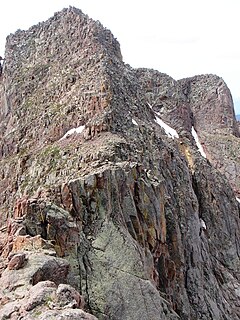
Mount Julian is a mountain summit in the northern Front Range of the Rocky Mountains of North America. The 12,933-foot (3,942 m) peak is located in the Rocky Mountain National Park Wilderness, 12.2 miles (19.7 km) west of the Town of Estes Park in Larimer County, Colorado, United States. The mountain was named in honor of Julian Hayden, a civil engineer who lived in Estes Park.

Mount Sheridan el. 10,313 feet (3,143 m) is a prominent mountain peak overlooking Heart Lake in the Red Mountains of Yellowstone National Park. The peak is named in honor of General Philip H. Sheridan, U.S. Army, one of the early protectors of the park.

Mount Doane el. 10,551 feet (3,216 m) is a mountain peak in the Absaroka Range in Yellowstone National Park. The peak is named for Lieutenant Gustavus Cheyney Doane, a U.S. Army cavalry officer who escorted the Washburn-Langford-Doane Expedition into Yellowstone in 1870. During that expedition, Doane and Nathaniel P. Langford ascended several peaks east of Yellowstone Lake.

Mount Jackson el. 8,231 feet (2,509 m) is a mountain peak just north of the Madison River, in the Gallatin Range of Yellowstone National Park. Mount Jackson is named in honor of William Henry Jackson, chief photographer of the Hayden Geological Survey of 1871 and a member of several subsequent geological surveys in the park. Jackson's photographs are some of the earliest ever taken in Yellowstone. The name was suggested by a park naturalist in 1935 but not awarded until 1937 when Jackson, who was still living gave his approval. Jackson visited the park regularly until his death in 1942.

Mount Langford el. 10,623 feet (3,238 m) is a mountain peak in the Absaroka Range in Yellowstone National Park. The peak is named for Nathaniel P. Langford, the first superintendent of Yellowstone and a leader of the Washburn–Langford–Doane Expedition to Yellowstone in 1870. The expedition and Langford's subsequent promotion in Scribner's helped in the creation of the park in 1872.
Mount Chittenden el. 10,182 feet (3,103 m) is a mountain peak in the Absaroka Range in Yellowstone National Park. The peak was named by Henry Gannett of the Hayden Geological Survey of 1878 for George B. Chittenden. Chittenden was a Geological Survey member who had worked with Gannett, Hayden and others in surveys in Montana, Idaho and Wyoming. Chittenden never participated in any of the Yellowstone surveys.
Mount Stevenson el. 10,230 feet (3,120 m) is a mountain peak in the Absaroka Range of Yellowstone National Park. Mount Stevenson was named in 1871 by geologist Ferdinand Hayden during the Hayden Geological Survey of 1871 for his friend and chief assistant, James Stevenson (1840–1888). Stevenson, who had run away from home as a young boy, first met Hayden in 1853 during an exploration of the Dakota Badlands. In 1866, Stevenson began working for Hayden and did so until 1879. Hayden specifically cited Stevenson's loyalty to him in his 1872 report on the 1871 survey of the park. Stevenson Island on Yellowstone Lake is also named for James Stevenson.
My principal assistant, Mr. James Stevenson, labored with his usual efficiency and fidelity throughout the entire trip. In honor of his great services not only during the past season, but for over twelve years of unremitting toil as my assistant, oftentimes without pecuniary reward, and with little of the scientific recognition that uaually comes to the original explorer, I have desired that one of the principal islands of the lake and one of the noble peaks reflected in its clear waters should bear his name forever.

Mount Jackson is a high and prominent mountain summit in the northern Sawatch Range of the Rocky Mountains of North America. The 13,676-foot (4,168 m) thirteener is located in the Holy Cross Wilderness of White River National Forest, 9.0 miles (14.5 km) west-southwest of the Town of Minturn in Eagle County, Colorado, United States. The mountain was named in honor of photographer William Henry Jackson, who accompanied the Hayden Survey in the 1870s.
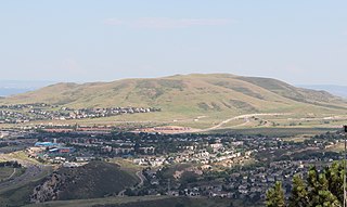
Green Mountain is a mesa on the eastern flank of the Front Range of the Rocky Mountains of North America. The 6,854-foot (2,089 m) mesa summit is located in William Frederick Hayden Park in the City of Lakewood, Colorado, United States, 4.0 miles (6.5 km) west of the municipal center of Lakewood in Jefferson County.

Ginseng Mountain is a mountain located in the Catskill Mountains of New York northeast of Windham. Elm Ridge is located south, Mount Zoar is located east-southeast, and Mount Hayden is located northwest of Ginseng Mountain.
Mount Zoar is a mountain located in the Catskill Mountains of New York northeast of Windham. Kate Hill is located east-southeast, Ginseng Mountain is located west-northwest, and Mount Hayden is located northwest of Mount Zoar.
Mount Nebo is a mountain located in the Catskill Mountains of New York northeast of Windham. Mount Hayden is located southeast, and Mount Pisgah is located northwest of Mount Nebo.


