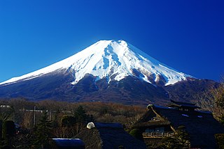
Mount Fuji, located on the island of Honshū, is the highest mountain in Japan, standing 3,776.24 metres (12,389.2 ft). It is also the second-highest volcano located on an island in Asia, and seventh-highest peak of an island on Earth. Mount Fuji is an active stratovolcano that last erupted from 1707 to 1708. The mountain stands about 100 kilometres (62 mi) south-west of Tokyo, and can be seen from there on clear days. Mount Fuji's exceptionally symmetrical cone, which is snow-capped for about 5 months a year, is commonly used as a cultural icon of Japan and it is frequently depicted in many arts and photographs, as well as visited by sightseers and climbers.
Yoho National Park is a national park of Canada in British Columbia. It is located in the Rocky Mountains along the western slope of the Continental Divide of the Americas in southeastern British Columbia. The word Yoho is a Cree expression of amazement or awe, and it is an apt description for the spectacular landscape of massive ice fields and mountain peaks that rank among the highest in the Canadian Rockies. Yoho NP is bordered by Kootenay National Park on the southern side and Banff National Park on the eastern side in Alberta.

The Humboldt–Toiyabe National Forest (HTNF) is the principal U.S. National Forest in the U.S. state of Nevada, and has a smaller portion in Eastern California. With an area of 6,289,821 acres (25,454.00 km2), it is the largest National Forest of the United States outside Alaska.

The Japanese Alps is a series of mountain ranges in Japan which bisect the main island of Honshu. The name was coined by English archaeologist William Gowland, and later popularized by Reverend Walter Weston (1861–1940), an English missionary for whom a memorial plaque is located at Kamikōchi, a tourist destination known for its alpine climate. When Gowland coined the phrase, he was only referring to the Hida Mountains, but it now also applies to the Kiso Mountains and Akaishi Mountains.

Mount Assiniboine, also known as Assiniboine Mountain, is a pyramidal peak mountain located on the Great Divide, on the British Columbia/Alberta border in Canada.

Mount Mansfield is the highest mountain in Vermont with a summit that peaks at 4,395 feet (1,340 m) above sea level. The summit is located within the town of Underhill in Chittenden County; the ridgeline, including some secondary peaks, extends into the town of Stowe in Lamoille County, and the mountain's flanks also reach into the town of Cambridge.

Mount Tai is a mountain of historical and cultural significance located north of the city of Tai'an, in Shandong province, China. The tallest peak is the Jade Emperor Peak, which is commonly reported as 1,545 metres (5,069 ft) tall, but is described by the PRC government as 1,532.7 metres (5,029 ft).

Mount Andromeda is located within the Columbia Icefield on the boundary of Banff and Jasper national parks. The mountain can be seen from the Icefields Parkway (#93) near Sunwapta Pass and is 2.3 km WSW of Mount Athabasca. Mt. Andromeda was named in 1938 by Rex Gibson, former president of the Alpine Club of Canada, after Andromeda, the wife of Perseus. From the Climber's Guide:

The Taconic Mountains or Taconic Range are a range of the Appalachian Mountains, running along the eastern border of New York State and adjacent New England from northwest Connecticut to western Massachusetts, north to central western Vermont. A physiographic region of the larger New England province, the range includes notable summits, including its high point, 3,840 feet (1,170 m) Mount Equinox In Vermont, and 3,489 feet (1,063 m) Mount Greylock, the highest point in Massachusetts.

Mount Banahaw is a potentially active volcano on Luzon in the Philippines. The three-peaked volcano complex is located between the provinces of Laguna and Quezon and is the tallest mountain in the Calabarzon region dominating the landscape for miles around.
The Western Maine Lakes and Mountains region spans most of Maine's western border with New Hampshire. A small part of the scenic White Mountain National Forest is located in this area. The region consists of Oxford County, Androscoggin County, Franklin County, as well as northern York and interior Cumberland Counties. The largest cities in the region are Lewiston and Auburn. Notable towns include Bethel, Bridgton, Oxford, Rangeley, and Rumford. Many of the state's highest peaks are located in the region, although the highest, Mount Katahdin, is not.

Mount Saskatchewan is a mountain located in the North Saskatchewan River valley of Banff National Park, in the Canadian Rockies of Alberta, Canada.

The North Shore Mountains are a mountain range overlooking Vancouver in British Columbia, Canada. Their southernmost peaks are visible from most areas in Vancouver and form a distinctive backdrop for the city.

The Chumash Wilderness is a 38,150 acres (15,440 ha) wilderness area within the southern Los Padres National Forest. It is located in the Transverse Ranges, in northern Ventura County and southwestern Kern County in California.

Mount Odin is a mountain in Qikiqtaaluk, Nunavut, Canada. It is located in Auyuittuq National Park along the Akshayuk Pass, 46 km (29 mi) north of Pangnirtung and south of Mount Asgard. Mount Odin is the highest mountain on Baffin Island.

Mount Silverheels is a high and prominent mountain summit in the Front Range of the Rocky Mountains of North America. The 13,829-foot (4,215 m) thirteener is located in Pike National Forest, 4.9 miles (7.9 km) northeast of the Town of Alma in Park County, Colorado, United States.
White Rock, 2,550 feet (780 m), is the high point on a 7 mi (11 km) ridgeline in the Taconic Mountains. The ridge is located in the tri-state corner of New York, Massachusetts, and Vermont in the towns of Petersburgh, Williamstown, and Pownal. The ridge has several distinct knobs; those with names are, from south to north: White Rocks, 2,365 feet (721 m); Smith Hill, 2,330 feet (710 m); White Rock, the high point 2,550 feet (780 m); and Bald Mountain 2,485 feet (757 m). The Snow Hole, located along the ridgeline between Bald Mountain and the White Rock, is a crevasse in which snow can be found well into the summer.

Mount Doom is a fictional volcano in J.R.R. Tolkien's Middle-earth legendarium. It is located in the northwest of the Black Land of Mordor and close to Barad-dûr. Alternative names, in Tolkien's invented language of Sindarin, include Orodruin and Amon Amarth.
Mount Williams is the 4th highest peak in the Commonwealth of Massachusetts. It is located in the Greylock Range in Berkshire County. Its altitude is 2,951 feet.

Mount Seymour Provincial Park is a park in Vancouver, British Columbia's North Shore Mountains. With an area of 35 square kilometres, it is located approximately 15 kilometres north of Downtown Vancouver. The park, named after Frederick Seymour, was established in 1936. Mount Seymour Provincial Park provides visitors with a variety of recreational activities and animals with natural habitat.

