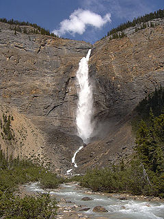
Yoho National Park is located in Canada's Rocky Mountains along the western slope of the Continental Divide of the Americas in southeastern British Columbia. Yoho NP is bordered by Kootenay National Park on the southern side and Banff National Park on the eastern side in Alberta. The name Yoho comes from the Cree word for awe and wonder.

Mount Robson Provincial Park is a vast provincial park in the Canadian Rockies with an area of 2,249 km². The park is located entirely within British Columbia, bordering Jasper National Park in Alberta. The B.C. legislature created the park in 1913, the same year as the first ascent of Mount Robson by a party led by Conrad Kain. It is the second oldest park in the provincial system. The park is named for Mount Robson, which has the highest point in the Canadian Rockies and is located entirely within the park.

The Virunga Mountains are a chain of volcanoes in East Africa, along the northern border of Rwanda, the Democratic Republic of the Congo (DRC), and Uganda. The mountain range is a branch of the Albertine Rift Mountains, which border the western branch of the East African Rift. They are located between Lake Edward and Lake Kivu. The name "Virunga" is an English version of the Kinyarwanda word ibirunga, which means "volcanoes".

Mount Brazeau is a mountain in Alberta, Canada.

Mount Hotham is a mountain in the Victorian Alps of the Great Dividing Range, located in the Australian state of Victoria. The mountain is located approximately 357 kilometres (222 mi) north east of Melbourne, 746 kilometres (464 mi) from Sydney, and 997 kilometres (620 mi) from Adelaide by road. The nearest major road to mountain is the Great Alpine Road. The mountain is named after Charles Hotham, Governor of Victoria from 1854 to 1855.

Mount Saskatchewan is a mountain located in the North Saskatchewan River valley of Banff National Park, in the Canadian Rockies of Alberta, Canada.

Shanks is an unincorporated community in Hampshire County in the U.S. state of West Virginia. According to the 2000 census, the Shanks community has a population of 806.

Mount Frissell, 2,454 feet (748 m), located on the border of southwest Massachusetts and northwest Connecticut, is a prominent peak of the Taconic Range.

South Branch Mountain is a mountain ridge that runs southwest to northeast through Hampshire and Hardy counties in the Eastern Panhandle of the U.S. state of West Virginia, rising to its greatest elevation of 3,028 feet above sea-level in the Nathaniel Mountain Wildlife Management Area. South Branch Mountain is among the largest and most prominent of the mountains in the Ridge-and-valley Appalachians of the Eastern Panhandle region. It forms the eastern edge of the South Branch Potomac River Valley from Springfield to Moorefield. The mountain was originally named Jersey Mountain by colonial settlers in the eighteenth century after Jersey.

Mount Hector is a 3,394-metre (11,135-foot) mountain summit located in the Bow River valley of Banff National Park, in the Canadian Rockies of Alberta, Canada. The mountain was named in 1884 by George M. Dawson after James Hector, a geologist on the Palliser Expedition. The mountain is located beside the Icefields Parkway, 17 km (11 mi) north of Lake Louise.

According to the Book of Exodus, Mount Sinai is the mountain at which the Ten Commandments were given to Moses by God. In the Book of Deuteronomy, these events are described as having transpired at Mount Horeb. "Sinai" and "Horeb" are generally considered to refer to the same place by scholars.

Mount Arab, sometimes known as Arab Mountain, is a mountain located in the town of Piercefield, New York, in the northern part of the Adirondack Mountain Range. At the summit of this mountain is a large fire tower and a ranger station known as the Arab Mountain Fire Observation Station. Because hiking to the summit of this mountain does not take very long and because it offers excellent views of the surrounding mountains and lakes, it is an extremely popular location for tourists and hikers of the Northern Adirondacks.

Mount Odin is a mountain in Qikiqtaaluk, Nunavut, Canada. It is located in Auyuittuq National Park along the Akshayuk Pass, 46 km (29 mi) north of Pangnirtung and south of Mount Asgard. Mount Odin is the highest mountain on Baffin Island.

Mount Emmons is a mountain located in the Adirondack Mountains near the southern edge of Franklin County, New York, United States.

Alander Mountain, 2,239 feet (682 m), is a prominent peak of the south Taconic Mountains; it is located in southwest Massachusetts and adjacent New York. Part of the summit is grassy and open and part is covered with scrub oak and shrubs; the sides of the mountain are wooded with northern hardwood tree species. Views from the top include the southern Taconic Mountains, the Hudson River Valley including the Catskills. Several trails traverse Alander Mountain, most notably the 15.7 mi (25.3 km) South Taconic Trail, which passes just beneath the summit.

Mount Pisgah is a mountain located in the Catskill Mountains of New York north of Windham. Steenburg Mountain is located northwest, Richtmyer Peak is located west, and Mount Nebo is located southeast of Mount Pisgah.

Donatos Mountain is a mountain located in the Catskill Mountains of New York south of Cobleskill. Mount Shank is located northwest, Warnerville Hill is located south-southeast, and Petersburg Mountain is located southeast of Donatos Mountain.

Barrack Zourie is a mountain in Schoharie County, New York. It is located north of Cobleskill. Pine Hill is located west-northwest and Mount Shank is located south-southwest of Barrack Zourie.

Hogback is a mountain in Schoharie County, New York. It is located northeast of Cobleskill. Barrack Zourie is located northwest and Mount Shank is located southwest of Hogback.


