
Webb is the northernmost town in Herkimer County, New York, United States. As of the 2020 Census it had a population of 1,797.

The Sangre de Cristo Mountains are the southernmost subrange of the Rocky Mountains. They are located in southern Colorado and northern New Mexico in the United States. The mountains run from Poncha Pass in South-Central Colorado, trending southeast and south, ending at Glorieta Pass, southeast of Santa Fe, New Mexico. The mountains contain a number of fourteen thousand foot peaks in the Colorado portion, as well as several peaks in New Mexico which are over thirteen thousand feet.

North Mountain is a peak in the Catskill Mountains of New York, on the border between the towns of Catskill and Hunter, in Greene County. It is part of the Catskill Escarpment. Cairo Round Top is located northeast and Artists Rock is located southeast of North Mountain.

The Chemehuevi Mountains are a mountain range that are found at the southeast border of San Bernardino County in southeastern California and are adjacent the Colorado River. Located south of Needles, California and northwest of the Whipple Mountains, the mountains are oriented in a north–south direction, and stretch for approximately 15 miles (24 km) in length.

South Carter Mountain is a mountain located in Coos County, New Hampshire. The mountain is part of the Carter-Moriah Range of the White Mountains, which runs along the northern east side of Pinkham Notch. South Carter is flanked to the northeast by Middle Carter Mountain and to the southeast Mount Hight.

St Donats is a village and community in the Vale of Glamorgan in south Wales, located just west of the small town of Llantwit Major. The community includes the village of Marcross and the hamlets of Monknash and East and West Monkton. It is named after the 6th-century saint, Dunwyd, a friend of Saint Cadoc. It had a population of 732 in 2011.
Spaulding Mountain is a mountain located in Franklin County, Maine. Spaulding Mountain is flanked to the northeast by Sugarloaf Mountain, and to the southeast by Mount Abraham.

Kibby Mountain is a mountain located in Franklin County, Maine, about 3.5 mi (5.6 km) east of the Canada–United States border. Kibby Mountain is flanked to the southeast by Spencer Bale Mountain.

Indian Head Mountain is a 3,573 ft (1,089 m) mountain located in the southeast corner of Greene County, New York. The mountain, named for the appearance of its profile, is part of the Devil's Path range of the Catskill Mountains. To the northwest, Indian Head is separated from Twin Mountain by Jimmy Dolan Notch; to the southeast, Indian Head is flanked by Plattekill Mountain.

Eagle Mountain is a mountain located in Ulster County, New York. The mountain is part of the Catskill Mountains. Eagle Mountain is flanked to the north by Haynes Mountain, to the southwest by Doubletop Mountain and Graham Mountain, and to the southeast by Big Indian Mountain.
Fir Mountain is a mountain located in Ulster County, New York. The mountain is part of the Catskill Mountains. Fir Mountain is flanked to the northwest by Big Indian Mountain, and to the southeast by Spruce Mountain.
The river Chimenticook is a tributary of the Saint John River, flowing in the canton T13 R13 Wels, in the Aroostook County, in North of Maine, in United States.
The East Branch Pockwock Stream is a tributary of the Pocwock River, flowing in Townships T17 R13 Wels and T16 R13 Wels, in the Aroostook County, in North Maine Woods, in Maine, the United States.
Catamount Mountain is a 1,814-foot-tall (553 m) mountain in the Adirondack Mountains of New York. It is located southeast of South Colton in St. Lawrence County. In 1917, a 35-foot-tall (11 m) steel fire lookout tower was built on the mountain. The tower ceased fire lookout operations and was later removed in the early 1980s.

Huntersfield Mountain is a mountain located in the Catskill Mountains of New York north-northwest of Ashland. Ashland Pinnacle is located east, and Tower Mountain is located south-southeast of Huntersfield Mountain. It is the highest point in Schoharie County and it is ranked 9 of 62 on the list of New York County High Points.
Petersburg Mountain is a mountain located in the Catskill Mountains of New York southeast of Cobleskill. Warnerville Hill is located northwest, and Donats Mountain is located northwest of Petersburg Mountain. In 1940, a 67-foot-6-inch-tall (20.57 m) steel fire lookout tower was built on the mountain. The tower was closed at the end of the 1971 season, and later transferred to Schoharie County for use as a radio tower. The tower site is closed to the public.
Mount Shank is a mountain located in the Catskill Mountains of New York northwest of Cobleskill. Hogback is located northeast, and Donats Mountain is located southeast of Mount Shank.
Warnerville Hill is a mountain in Schoharie County, New York. It is located south-southeast of Cobleskill. Donats Mountain is located north and Petersburg Mountain is located southeast of Warnerville Hill.
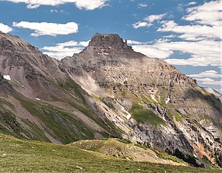
Potosi Peak is a 13,786-foot-elevation (4,202-meter) mountain summit located in Ouray County of Colorado, United States. It is situated five miles southwest of the community of Ouray, on land managed by Uncompahgre National Forest. It is part of the Sneffels Range which is a subset of the San Juan Mountains, which in turn is part of the Rocky Mountains. It is situated west of the Continental Divide, 2.2 miles south of Whitehouse Mountain, and 2.5 miles southeast of Mount Sneffels. Potosi ranks as the 113th-highest peak in Colorado, and the fourth-highest in the Sneffels Range. Recreation enthusiasts heading for Yankee Boy Basin traverse below the southern base of the mountain. Topographic relief is significant as the southeast aspect rises 4,000 feet above the Camp Bird Mine in approximately 1.5 mile. The mining activity in the immediate area produced significant amounts of gold and silver. "Potosi" in Quechuan language translates to "great wealth.". The mountain's name, which has been officially adopted by the United States Board on Geographic Names, was in use before 1899 when Henry Gannett published it in A Dictionary of Altitudes in the United States.
Washburn Mountain is a 1,496-foot-tall (456 m) mountain in New York. It is located south-southeast Copake Falls in Columbia County. From 1932 to 1964, the mountain was the location of a 60-foot-tall (18 m) steel fire lookout tower now located on Beebe Hill. Alander Mountain is located southeast of Washburn Mountain.

