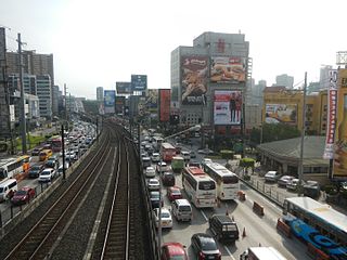
Epifanio de los Santos Avenue, commonly referred to by its acronym EDSA, is a limited-access circumferential highway around Manila, the capital of the Philippines. It is the main thoroughfare in Metro Manila passing through 6 of the capital region's 17 local government units, namely, from north to south, Caloocan, Quezon City, San Juan, Mandaluyong, Makati and Pasay.

The Pan-Philippine Highway, also known as the Maharlika Highway is a 3,517-kilometer (2,185 mi) network of roads, expressways, bridges, and ferry services that connect the islands of Luzon, Samar, Leyte, and Mindanao in the Philippines, serving as the country's principal transport backbone. It is the longest highway in the Philippines that forms the country's north–south backbone component of the National Route 1 (N1) of the Philippine highway network. The entire highway is designated as Asian Highway 26 (AH26) of the Asian Highway Network.
The Marcos Highway, also known as Marikina–Infanta Highway, or Marilaque Road or Marikina-Infanta Road, is a scenic mountain 117.5-kilometer (73.0 mi) highway that connects Metro Manila with Infanta, Quezon in the Philippines.

Commonwealth Avenue, formerly known as Don Mariano Marcos Avenue, named after the father of President Ferdinand Marcos, is a 12.4-kilometer (7.7 mi) highway located in Quezon City, Philippines, which spans from 6 to 18 lanes and is the widest in the Philippines. It is one of the major roads in Metro Manila and is designated as part of Radial Road 7 (R-7) of the older Manila arterial road system and National Route 170 (N170) of the Philippine highway network.

Circumferential Road 5 (C-5), informally known as C-5 Road, is a network of roads and bridges that all together form the fifth beltway of Metro Manila in the Philippines. Spanning some 32.5 kilometers (20.2 mi), it connects the cities of Las Piñas, Makati, Parañaque, Pasay, Pasig, Quezon City, Taguig, and Valenzuela.

Katipunan Avenue is a major avenue in Quezon City, Metro Manila, Philippines. It runs in a north–south direction from the University of the Philippines Diliman, intersecting with Tandang Sora Avenue at its northernmost point, down to the Manila Philippines Temple of The Church of Jesus Christ of Latter-day Saints, intersecting with White Plains Avenue at its southernmost point.

Mindanao Avenue is an eight-to-ten lane divided avenue connecting EDSA and NLEX and is a part of Circumferential Road 5 (C-5) in Metro Manila, Philippines. It is one of the three parallel roads that connects Tandang Sora and Congressional Avenues ; that is why it was named after the southernmost mainland of the Philippines, Mindanao. It used to be a 2-kilometer (1.2 mi) highway connecting North Avenue and Congressional Avenue, but as a part of the C-5 projects, Mindanao Avenue was extended to EDSA in the south and to Quirino Highway to the north. The new roads opened in 2000.

Aurora Boulevard is a four-to-ten lane major thoroughfare in Quezon City and San Juan in Metro Manila, Philippines. It was named after Doña Aurora Quezon, the consort of Commonwealth President Manuel Luis Quezon. It is one of the major roads in the commercial district of Araneta City in Cubao. Line 2 follows the alignment of this road.

Quezon Boulevard is a short stretch of highway in Manila, Philippines running north–south through the district of Quiapo. It is a six- to ten-lane 1.1-kilometer-long (0.68 mi) divided boulevard designated as a component of National Route 170 (N170) of the Philippine highway network and Radial Road 8 (R-8) of Manila's arterial road network which links the center of Manila to North Luzon Expressway in Quezon City in the north. The boulevard is the main access to the popular Quiapo Church and is one of the main thoroughfares of the University Belt area.

Padre Burgos Avenue, also known as Padre Burgos Street, is a 14-lane important thoroughfare in Manila, Philippines. It was named after one of the martyred priests, Jose Burgos. It is a road in the center of the city providing access to several important thoroughfares like Taft Avenue, Rizal Avenue, Roxas Boulevard, and Quezon Boulevard. The avenue is a component of Circumferential Road 1 (C-1) of Manila's highway system and National Route 150 (N150) and National Route 170 (N170) of the Philippine highway network. The Manila City Hall can be accessed using this road, and so is the Rizal Park and Intramuros.

North Avenue is a major road located in Quezon City within the Diliman area of northeastern Metro Manila, Philippines. It runs east–west through barangays Bagong Pag-asa, Project 6, and Vasra, forming the northern part of the North Triangle area. The street is located in Quezon City's mixed-use and government area, known for its malls, condominiums, hotels, and the upcoming QC CBD. It is also home to the SM City North EDSA, Trinoma, and Ayala Malls Vertis North located on the avenue's junction with Epifanio de los Santos Avenue (EDSA). The entire avenue is designated as National Route 173 (N173) of the Philippine highway network.

Colonel Bonny Serrano Avenue, formerly called and still referred to as Santolan Road, is a major east–west thoroughfare in the Eastern Manila District of Metro Manila, Philippines, running between San Juan and Quezon City. It forms the northern limit of San Juan and the southern limit of Quezon City's New Manila and Cubao districts and links the Philippine National Police headquarters in Camp Crame with the Armed Forces of the Philippines headquarters in Camp Aguinaldo. The avenue runs from the border of barangays Corazon de Jesus, St. Joseph, and Little Baguio in San Juan in the west to barangays Libis and Blue Ridge B near Quezon City's border with Marikina in the east. It was named after the decorated Korean War hero, Venancio "Bonny" Serrano.

The Dimasalang Street is a major road between the districts of Sampaloc and Santa Cruz in the City of Manila. Running 1.9 kilometers (1.2 mi) in the north-south direction, it connects Lacson Avenue and Laon Laan Street to Blumentritt Road, near the city's border with Quezon City. It is named after Dimasalang, one of the pen names of the Philippine national hero José Rizal.

Congressional Avenue, is a 6-kilometer (3.7 mi) highway located in Quezon City, Philippines, which spans from 6 lanes. It is one of the secondary roads in Metro Manila and part of it is designated as part of Circumferential Road 5 (C-5) of the Manila arterial road system and National Route 129 (N129) of the Philippine highway system.

West Avenue is a major road located in Quezon City within the Diliman area of northeastern Metro Manila, Philippines. It runs north–south through the western edge of the barangay of West Triangle. The street is located in Quezon City's commercial-residential area, known for its restaurants, car shops, schools, and villages. It is also home to the old Delta theater located on the avenue's junction with Quezon Avenue. The avenue is a component of National Route 171 (N171) of the Philippine highway network.

The East Avenue is a major street located within the Diliman area of Quezon City, Philippines. It runs north-south through the eastern edge of Triangle Park. The street is located in Quezon City's government area, known for different national and local government institutions, offices, and hospitals. It is also home to the Quezon City Hall Complex located on the avenue's junction with Elliptical Road. The entire avenue is designated as National Route 174 (N174) of the Philippine highway network.

Tandang Sora Avenue is a major east-west thoroughfare bisecting Quezon City in Metro Manila, the Philippines. It is a two-to-six lane highway and municipal road that runs for 9.6 kilometers (6.0 mi) from its eastern terminus at Magsaysay Avenue in Pansol and U.P. Campus in Diliman to its western terminus at Quirino Highway in Baesa and Talipapa in Novaliches, crossing Barangays Culiat, New Era, Pasong Tamo, Tandang Sora, and Sangandaan.
National Route 180 (N180) is a secondary national route that forms part of the Philippine highway network, running from Cubao, Quezon City to Ermita, Manila.
National Route 170 (N170) is a national secondary road of the Philippine highway network. It passes through the northern part of Metro Manila, traversing through the cities of Quezon City, Manila, and Pasay.
