Gilmore Avenue, Quezon City

Last updated
Gilmore Avenue
N184 (Philippines).svg
Gilmore Avenue, Quezon City sign.svg
Gilmore Avenue New Manilajwilz.jpg
Gilmore Avenue, looking south from its intersection with 12th Street
Former name(s) Governor Gilmore Street
Gilmore Street
Namesake Eugene Allen Gilmore
Maintained by Department of Public Works and Highways
Length 1.476 km [1] (0.917 mi)
Component
highways
  • N184 (Philippines).svg N184 from Aurora Boulevard to Nicanor Domingo Street
Location Quezon City
North end Eulogio Rodriguez Sr. Avenue
Major
junctions
South end Nicanor Domingo Street
Granada Street
Other
Known for Computer retail

Gilmore Avenue, formerly known as Gilmore Street, is a two-lane, one-way road in Quezon City, Metro Manila, the Philippines. It runs one-way from Eulogio Rodriguez Sr. Avenue in New Manila and terminates at Nicanor Domingo Street in Valencia, continuing on as the two-way Granada Street until it reaches the city border with San Juan, where it becomes Ortigas Avenue.

Contents

The road is named for Eugene Allen Gilmore, Vice Governor-General of the Philippines from 1922 to 1929 who twice served as acting Governor-General. [2] The road is well known as a major IT hub for the number of computer retail shops located at its intersection with Aurora Boulevard. [3]

History

Gilmore Avenue was originally named and constructed sometime before 1943 as Governor Gilmore Street, serving as one of four north-south thoroughfares for the New Manila Subdivisions established a few decades prior. It served as a one-way southbound counterpart to the one-way northbound Pacific Avenue (now Doña Hemady Avenue), [4] [5] which was originally named as a reference to America’s successful acquisition of the Pacific Rim islands that included the Philippines during the Spanish–American War in 1898. [6]

South of the New Manila area, new subdivisions and a shopping center were being developed in what would become the Greenhills area in the municipality of San Juan del Monte, Rizal (now San Juan City, Metro Manila) in the 1960s and 1970s, [7] and so the road became known as a passageway for motorists to Greenhills and Ortigas Avenue itself. [3]

Commercial development

In the 1990s, the Greenhills Shopping Center became known as a hub for computer parts and accessories at affordable prices for computer hobbyists and IT enthusiasts alike until the computer boom in the 1990s made computers mainstream and increased the demand for computer retail markets. As the Greenhills Shopping Center had become too crowded for the increasing demand of the computer boom, a computer retail store owner in 1997 decided to set up shop along the once-desolate Gilmore Avenue. [3] [8]

According to local computer retailer PC Options, the business was the first computer retail store to open in the area, claiming that contrary to popular belief, the "PC" in the name does not actually refer to personal computers, but rather, coincidentally was the initials of the shop's founder and owner. [3] [8] As the area was being developed commercially, PC Options became popular for pioneering the do-it-yourself concept for computer customizations in the local market, serving as the catalyst for other computer retail shops to open in the area. [3] [8]

As several computer shops in Greenhills had to close down due to renovations at the shopping center itself, Gilmore became established as a major IT hub in Metro Manila, with the Gilmore name becoming synonymous to computer retail. [3]

No-contact apprehension controversy

On July 1, 2022, the Quezon City government began fully implementing its No Contact Apprehension Policy on several major roads in the city. As a result, closed-circuit television cameras were installed along the intersection of E. Rodriguez Sr. Avenue and Gilmore Avenue.

However, the policy has been criticized by motorists due to the unclear directives on the proper way to navigate the intersection correctly. In particular, motorists complained on social media after they were ticketed for turning "in the wrong lane" towards Gilmore Avenue, where the rightmost lane along E. Rodriguez Sr. Avenue is cut in half by Quezon City's bike lane network. [9]

Route description

Gilmore Avenue is a major thoroughfare that acts as a southbound corridor for connecting the neighborhoods of New Manila and the neighborhood and commercial area along Tomas Morato Avenue to Ortigas Avenue, the cities of San Juan and Mandaluyong, and the Greenhills Shopping Center.

Its segment within New Manila from E. Rodriguez Sr. Avenue to Aurora Boulevard is notorious for many vehicular accidents, with an average of 0.1 to 0.3 accidents per day and 91.9 accidents a year. Many of these accidents are attributed towards overspeeding, improper overtaking, and disregarding of traffic signs as a result of the wide single-direction lane width, and due to poor visibility during night time. [10]

Landmarks

Computer and IT hub

The Aurora Boulevard intersection of Gilmore Avenue is a popular hub for IT-related products and services for computers and related components. Both the southern corners of Gilmore Avenue and Aurora Boulevard are filled with stores selling different kinds of computers and their accessories, both secondhand and brand-new. [11]

Due to the COVID-19 pandemic in the Philippines, computer retail stores in the area reported a five-fold increase in demand for laptops and computers due to remote work and distance education arrangements. [11]

Nearby transport

Bus Route 11 (Gilmore-Taytay) serves the commercialized section of Gilmore Avenue, with its northern namesake terminus being located at the intersection of Gilmore Avenue and Nicanor Domingo Street. [12] It is also served by Bus Route 10 (Doroteo Jose-Cubao), which stops at the intersection of Gilmore Avenue and Aurora Boulevard [13] Route 6 (Quezon City Hall-Gilmore) of the Quezon City Bus Service has a stop in the Gilmore commercial area and a terminal at the nearby Robinsons Magnolia along Doña Hemady Avenue. [14]

The nearest mass transport station from Gilmore Avenue is the Gilmore station of the Manila LRT Line 2, which was named after the road itself, and the future N. Domingo station of the MRT-4 monorail line.

The segment of Gilmore Avenue from Aurora Boulevard to Nicanor Domingo Street also contains a one-way partially-protected bike lane, linking the bike lane network along Aurora Boulevard and Granada Street.

Related Research Articles

<span class="mw-page-title-main">EDSA</span> Limited-access circumferential highway around Metro Manila

Epifanio de los Santos Avenue, commonly referred to by its acronym EDSA, is a limited-access circumferential highway around Manila, the capital city of the Philippines. It passes through 6 of Metro Manila's 17 local government units or cities, namely, from north to south, Caloocan, Quezon City, San Juan, Mandaluyong, Makati, and Pasay.

<span class="mw-page-title-main">V. Mapa station</span> LRT Line 2 station in Manila

V. Mapa station is an elevated Manila Light Rail Transit (LRT) station situated on Line 2. It is one of the four stations in the line with a reserve track nearby together with Santolan, Anonas and Araneta Center–Cubao. The station during its inception was formerly called as G. Araneta station but was renamed into the current name due to the minor realignment of some stations that has caused the change of proximity to the V. Mapa Street. The station serves the areas of Santa Mesa, Manila, Quezon City, and San Juan. The station is located at Ramon Magsaysay Boulevard, near its intersection with Victorino Mapa Street in Santa Mesa, Manila.

<span class="mw-page-title-main">España Boulevard</span> Major boulevard in Manila, Philippines

España Boulevard is an eight–lane major thoroughfare in Manila, the capital city of the Philippines, named after Spain, the country that formerly held the Philippines as an overseas territory. True to its name, several Spanish names abound the street. It starts at the Welcome Rotonda near the boundary of Quezon City and Manila and ends with a Y-intersection with Lerma and Nicanor Reyes Streets in Manila.

<span class="mw-page-title-main">Balete Drive</span> Street in Quezon City, Philippines

Balete Drive is an undivided two-lane street and main thoroughfare of New Manila, Quezon City, Philippines. The road is a major route of jeepneys and cabs, serving the New Manila area, connecting Eulogio Rodriguez Sr. Avenue and Nicanor Domingo Street in Quezon City.

<span class="mw-page-title-main">Marikina–Infanta Highway</span> Scenic road in the Philippines

The Marikina–Infanta Highway, also known as Marilaque Highway, as well as its former name Marcos Highway, Marilaque Road or Marikina-Infanta Road, is a scenic mountain 117.5-kilometer (73.0 mi) highway that connects Metro Manila with Infanta, Quezon in the Philippines. Motorists colloquially refer to the road as Marilaque Highway.

<span class="mw-page-title-main">Gilmore station (LRT)</span> LRT Line 2 station in Quezon City

Gilmore station is an elevated Manila Light Rail Transit (LRT) station situated on Line 2. It is located near Gilmore Avenue, Quezon City in Mariana, Quezon City. It is named after the nearby Gilmore Avenue, which in turn is named for Eugene Allen Gilmore, Vice Governor-General of the Philippines from 1922 to 1929 who twice served as acting Governor-General of the Philippines.

<span class="mw-page-title-main">Radial Road 6</span>

Radial Road 6 is the sixth radial road in Metro Manila, in the Philippines. It passes through the cities of Manila, Quezon City, San Juan, Pasig, and Marikina, as well as Cainta, and Antipolo in the province of Rizal up to Santa Maria, Laguna and Infanta, Quezon

<span class="mw-page-title-main">Circumferential Road 3</span> Third beltway of Metro Manilas highways

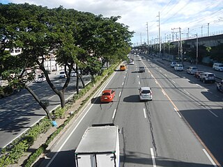
Circumferential Road 3 (C-3), informally known as the C-3 Road, is a network of roads and bridges that all together form the third beltway of Metro Manila in the Philippines. Spanning some 32.5 kilometers (20.2 mi), it connects the cities of Caloocan, Makati, Navotas, Pasay, Quezon City, and San Juan.

<span class="mw-page-title-main">Greenhills, San Juan</span> Barangay in Metro Manila, the Philippines

Greenhills is an administrative division in eastern Metro Manila, the Philippines. It is an urban barangay in San Juan and is the largest barangay in the city, covering a total area of 2.09 square kilometers (209 ha) that spans over a third of San Juan City's total land area.

<span class="mw-page-title-main">Aurora Boulevard</span> Road in the Philippines

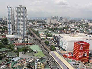
Aurora Boulevard is a four-to-ten lane major thoroughfare in Quezon City and San Juan in Metro Manila, Philippines. It was named after Doña Aurora Quezon, the consort of Commonwealth President Manuel Luis Quezon. It is one of the major roads in the commercial district of Araneta City in Cubao. Line 2 follows the alignment of the boulevard.

<span class="mw-page-title-main">Julia Vargas Avenue</span>

Julia Vargas Avenue is a central east–west arterial road that passes through Ortigas Center in Metro Manila, Philippines. It is a four-lane divided road with one-way protected bike lanes that runs parallel to Ortigas Avenue to the north and Shaw Boulevard to the south. The avenue stretches 2.3 kilometers (1.4 mi) from Eulogio Rodriguez Jr. Avenue in Ugong, Pasig in the east to Epifanio de los Santos Avenue (EDSA) in Wack-Wack Greenhills, Mandaluyong in the west.

<span class="mw-page-title-main">Gregorio Araneta Avenue</span>

Gregorio Araneta Avenue is a suburban arterial road in the Santa Mesa Heights area of Quezon City, northeastern Metro Manila, Philippines. It is a 6- to 8-lane divided avenue designated as part of Circumferential Road 3 (C-3) and physical continuation of Sergeant Rivera Street which travels from Santo Domingo Avenue at its north end near Balintawak in Quezon City, and meets N. Domingo Street in the south in San Juan near the border with Santa Mesa, Manila. En route, it intersects with Del Monte Avenue, Quezon Avenue, Eulogio Rodriguez Sr. Avenue and Magsaysay-Aurora Boulevard passing through barangays Balingasa, Manresa, Masambong, Sienna, Santo Domingo, Talayan, Tatalon, Santol, and Doña Imelda in Quezon City and Progreso in San Juan.

The Metro Rail Transit Line 4, also known as MRT Line 4, is an approved mass rapid transit line to be built in Metro Manila and Rizal in the Philippines.

<span class="mw-page-title-main">Index of Metro Manila–related articles</span>

The following is an alphabetical list of articles related to the Philippine capital region of Metro Manila.

<span class="mw-page-title-main">Granada Street</span>

Granada Street, also known as Senator Jose O. Vera Street, is a road in Quezon City, Metro Manila, the Philippines. It runs from Nicanor Domingo Street as an extension of Gilmore Avenue to the boundary with San Juan, where it terminates at Bonny Serrano Avenue and becomes Ortigas Avenue.

National Route 180 (N180) is a secondary national route that forms part of the Philippine highway network, running from Cubao, Quezon City to Ermita, Manila.

National Route 170 (N170) is a national secondary road of the Philippine highway network. It passes through the northern part of Metro Manila, traversing through the cities of Quezon City, Manila, and Pasay.

<span class="mw-page-title-main">Mariana, Quezon City</span> Barangay in Metro Manila, the Philippines

Mariana, is an administrative division in eastern Metro Manila, the Philippines. It is an urban barangay in Quezon City in a middle class residential and commercial area known as New Manila, which includes Barangay Mariana and the adjacent Barangay Damayang Lagi.

References

  1. "Road and Bridge Inventory". Department of Public Works and Highways. Retrieved March 13, 2022.
  2. Alcazaren, Paulo (January 4, 2014). "Origins of Metro Manila". The Philippine Star . PhilStar Daily, Inc. Archived from the original on January 6, 2014. Retrieved February 12, 2018.
  3. 1 2 3 4 5 6 "The "IT hub" in Gilmore Avenue". The Urban Roamer. 2012-10-06. Retrieved 2021-12-20.
  4. Map of Manila and Suburbs (Map). 1:20,000. The Chief of Engineers, Washington, D.C. 1943. Retrieved March 13, 2022.
  5. Manila North, Philippine Islands, Manila City, Luzon (Map). 1:12500. Its A.M.S. S901. United States. United States. Army Map Service. 1945.
  6. Ysmael, Rosary (December 19, 2020). "Doña Hemady—my great grand 'lola', not the street". The Diarist.ph. Retrieved March 13, 2022.
  7. "Ortigas & Company". 2016-10-28. Archived from the original on October 28, 2016. Retrieved 2021-12-20.
  8. 1 2 3 "PC Options -> About Us". www.pcoptionsph.com. Retrieved 2021-12-20.
  9. Tipan, Eric (June 30, 2022). "Motorists call out QC No Contact Apprehension "Trap"". Autoindustriya. Retrieved August 1, 2022.
  10. Road Crash Statistics along Gilmore Avenue in Quezon City 2005-2021. TEC-RSU-RCR-22-186 to 220. Freedom of Information Philippines: Metropolitan Manila Development Authority. 2022.
  11. 1 2 Demayo, Mark (May 30, 2020). "Laptop demand soars". ABS-CBN News . Retrieved August 1, 2022.
  12. "Resolution No. 71 Series of 2020" (PDF). Land Transportation Franchising and Regulatory Board . May 27, 2020. Retrieved January 10, 2022.
  13. "Resolution No. 109 Series of 2020" (PDF). Land Transportation Franchising and Regulatory Board . June 11, 2020. Retrieved January 10, 2022.
  14. "Quezon City QCity Bus Service". Quezon City Government. May 31, 2021. Retrieved September 28, 2022.

Coordinates: 14°37′3″N121°1′56″E / 14.61750°N 121.03222°E / 14.61750; 121.03222