E5 expressway (Philippines)

Last updated
E5 (Philippines).svg
C-5
NLEX Harbor Link
Route information
Maintained by NLEX Corporation
Length24.85 km (15.44 mi)
Segment 8.1 (Mindanao Avenue Link) – 2.7 km (1.7 mi)
Segment 9 (Karuhatan Link) – 2.4 km (1.5 mi)
Segment 10 (Harbor Link) – 8.25 km (5.13 mi) (including C-3–R-10 section)
Segment 8.2 (C-5 Link) – 11.5 km (7.1 mi) (construction pending)
Existed2010–present
Component
highways
  • C-5 C-5 from Mindanao Avenue to Karuhatan
  • E5 (Philippines).svg E5
Major junctions
West endAH26 (N120) sign.svg AH 26 (N120) (Radial Road 10) in Navotas
Major intersections
East endN128 (Philippines).svg N128 (Mindanao Avenue) in Valenzuela
Future: N129 (Philippines).svg N129 (Katipunan Avenue) / C.P. Garcia Avenue in Quezon City
Location
Country Philippines
Major cities Caloocan, Malabon, Navotas, Quezon City, Valenzuela
Highway system
  • Roads in the Philippines
E4 (Philippines).svg E4 E6 (Philippines).svg E6

NLEX Harbor Link (North Luzon Expressway Harbor Link) forms part of the Philippine expressway network. [1] [2] It runs from Congressional Avenue and Luzon Avenue, both components of Circumferential Road 5, in Quezon City to Radial Road 10 in Navotas, linking the North Luzon Expressway to the Port of Manila. Currently, its segment from Mindanao Avenue in Valenzuela to Navotas is operational.

Contents

History

The C-3-R-10 section of Segment 10 (Harbor Link) under construction at C-3 Road, 2019 2447NLEx Harbor Link 10.60 project.jpg
The C-3–R-10 section of Segment 10 (Harbor Link) under construction at C-3 Road, 2019

Construction of NLEX Segment 8.1 (Mindanao Avenue Link), the first segment of the Harbor Link project, broke ground on April 2, 2009, [3] with actual construction work beginning on April 21, 2009. [4] It was then opened on June 5, 2010. [5] The spur road became part of the C-5 Road North Extension and is built to provide another entry point to the expressway from Metro Manila and decongest Balintawak Interchange. [6]

In 2013–2014, the construction of NLEX Segments 9 (Karuhatan Link) and 10 (Harbor Link) broke ground. [7] [8] On March 18, 2015, NLEX Segment 9 was opened, providing continuation to Segment 8.1 that runs from the western side of the Harbor Link Interchange to MacArthur Highway in Karuhatan, Valenzuela.

On February 28, 2019, the main stretch of NLEX Segment 10 from MacArthur Highway to C-3 Road in Caloocan was inaugurated and opened to traffic. [9] [10] However, this section of NLEX Segment 10 was supposed to be operational in December 2016, [11] but was delayed repeatedly due to right of way issues and delayed ROW acquisition. On February 21, 2020, its C-3–R-10 section was partially opened up to its Malabon (Dagat-Dagatan) exit ramp. [12] On June 15, its remaining section up to Radial Road 10 was finally opened. [13] This section was originally expected to open in March 2020, but was delayed due to the COVID-19 pandemic.

Route description

The NLEX Harbor Link Project is the extension of the North Luzon Expressway that runs currently from Mindanao Avenue in Valenzuela at the east to Radial Road 10 in Navotas at the west, where an access to the Port of Manila is found. It aims to connect with Port of Manila, while improving cargo movement between NLEX and Radial Road 10. It is divided into four segments, namely: Segment 8.1 (Mindanao Avenue Link), 8.2 (C-5 Link / Citi Link), 9 (Karuhatan Link), and 10 (Harbor Link). [2] It forms part of the expressway's open section. Both Segments 8.1 and 9 are components of Circumferential Road 5 (C-5) of Manila's arterial road network.

Mindanao Avenue to NLEX main

NLEX Segment 8.1 (Mindanao Avenue Link) westbound towards Harbor Link Interchange NLEX Mindanao Avenue Link 05.jpg
NLEX Segment 8.1 (Mindanao Avenue Link) westbound towards Harbor Link Interchange

NLEX Segment 8.1 (Mindanao Avenue Link) is a four-lane, 2.7-kilometer (1.7 mi) expressway that runs from the Harbor Link Interchange to Mindanao Avenue in Valenzuela. Lying on the ground level east of the interchange, it begins at the intersection with Mindanao Avenue in Barangay Ugong and then approaches the Mindanao toll plazas, widening to 6 lanes serving only westbound traffics. It terminates at the Harbor Link Interchange with NLEX Main and continues to the west as Segment 9 (Karuhatan Link).

NLEX main to Karuhatan

NLEX Segment 9 (Karuhatan Link) westbound NLEX Karuhatan Link Jun 2022-1jwilz.jpg
NLEX Segment 9 (Karuhatan Link) westbound

NLEX Segment 9 (Karuhatan Link) is a four-lane, 2.4-kilometer (1.5 mi) expressway that runs from Harbor Link Interchange to MacArthur Highway in Karuhatan, Valenzuela. It is the first segment of the NLEX Harbor Link project. [14] It begins at the Harbor Link Interchange with NLEX Main, picking-up from where Segment 8.1 (Mindanao Avenue Link) left off. Lying on the ground level west of the interchange, it then traverses Barangays Gen. T. De Leon, Parada, and Maysan, where two exits towards the first two barangays, respectively, are found. It then enters Barangay Karuhatan, where it approaches the Karuhatan toll plaza, widening to 6 lanes serving only eastbound vehicles, and Segment 10 (Harbor Link) and finally terminates at MacArthur Highway.

Karuhatan to Navotas

NLEX Segment 10 southbound in Karuhatan, Valenzuela North Luzon Expressway Harbor Link Project 10.jpg
NLEX Segment 10 southbound in Karuhatan, Valenzuela
The C3-R10 section westbound NLEX Harbor Link Caloocan (C3 Road) area(2022)-3jwilz.jpg
The C3–R10 section westbound

NLEX Segment 10 (Harbor Link), the second phase of the NLEX Harbor Link project, is a four-lane, 5.65-kilometer (3.51 mi) fully elevated expressway which connects with the Karuhatan Link (Segment 9) in Valenzuela to C-3 Road in Caloocan, where two ramps carry it to the west for another 2.6 kilometers (1.6 mi) up to Radial Road 10 (R-10) in Navotas. [14] It begins at Karuhatan Exit with Segment 9 (Karuhatan Link) and MacArthur Highway. The section near the northern terminus traverses an industrial and residential area, which necessitated the demolition of numerous houses, buildings, and warehouses. It soon follows the railway right-of-way where it rises up to as high as 19 meters (62 ft) to provide necessary ground clearance for the viaduct carrying the future Manila–Clark Railway of the Philippine National Railways (PNR). It then crosses Tullahan River, where it enters Malabon. It then enters Caloocan, where past Samson Road and the PNR rolling stock shops in Caloocan, it shifts east of the railway's right of way, which also necessitated the demolition of a wet market. An exit to C-3 Road could then be found before meeting the Caloocan Interchange, where the expressway veers west as the C3–R10 spur alignment with connection to the under-construction NLEX Connector (NLEX-SLEX Connector Road) that would lead southwards to Manila. The 2.6-kilometer (1.6 mi) C3–R10 section runs above C-3 Road, where a westbound exit ramp towards Dagat-Dagatan Avenue could be found. It then crosses the Navotas River and enters Navotas, where it veers southeast towards R-10 and ends at the Navotas Interchange, which provides access to the Port of Manila via Mel Lopez Boulevard.

At the Navotas Interchange, the expressway has a possible future connection to the proposed NLEX–CAVITEX Port Expressway Link or Harbor Link Port Access Mobility Facility towards Manila–Cavite Expressway (CAVITEX) or Anda Circle, respectively. [15] [16]

Future

Segment 8.2 (NLEX–C-5 Link)

NLEX Segment 8.2, also named NLEX C-5 Link and NLEX Citi Link, [14] [17] will be an 11.5-kilometer (7.1 mi) segment part of the NLEX Harbor Link Project that will connect the existing NLEX Segment 8.1 (Mindanao Avenue Link) to Katipunan Avenue, a part of C-5. It is divided into two sections: the 8.30-kilometer (5.16 mi) Section 1 from Mindanao Avenue to Luzon Avenue and the 3.2-kilometer (2.0 mi) Section 2 from Luzon Avenue to C.P. Garcia Avenue. [2] [18] [19] The planned segment will at first run parallel to Republic Avenue before making a southward turn to Luzon Avenue after which it will then cross to Commonwealth Avenue and end at the intersection of C.P. Garcia and Katipunan Avenues. [14] The segment will include five interchanges at Mindanao Avenue, Quirino Highway, Regalado Avenue, Congressional and Luzon Avenues, and Katipunan and C.P. Garcia Avenues, with three local road crossings at Sauyo Road, Chestnut Avenue, and Commonwealth Avenue. [20] [21]

The project implementation has been delayed for years due to right of way issues, [22] [23] as it will affect informal settlers in 8 barangays of Quezon City. [24] Construction of the expressway segment's 2-kilometer (1.2 mi) Section 1A between Mindanao Avenue and Quirino Highway is set to commence in September 2021. [25]

Exits

Caloocan Interchange NLEX Harbor Link - C3 Road Caloocan Interchange 05.jpg
Caloocan Interchange
Malabon (Dagat-Dagatan) Exit Dagat-Dagatan Avenue Caloocan Navotas 02.jpg
Malabon (Dagat-Dagatan) Exit
Navotas Interchange (C-3-R-10 ramp) NLEX Harbor Link Manila terminusjwilz.jpg
Navotas Interchange (C-3–R-10 ramp)

This entire route is located in Metro Manila. Exit numbers are numbered by kilometer posts. The kilometer count, which would be shown here in its approximate values, increments east and west of Harbor Link Interchange as it branches off NLEX Main, with Rizal Park in Manila designated as kilometer 0. 

ProvinceCity/MunicipalitykmmiExitNameDestinationsNotes
Quezon City C.P. GarciaN129 (Philippines).svg N129 (Katipunan Avenue) / C.P. Garcia AvenueFuture eastern terminus; [18] C-5 segment of NLEX Harbor Link will start here. Possible link to the proposed C-5 Expressway
CongressionalN129 (Philippines).svg N129 (Congressional Avenue Extension, Luzon Avenue)
Regalado [26] Regalado Avenue
Quirino HighwayN127 (Philippines).svg N127 (Quirino Highway)
Valenzuela 15.99.9Mindanao AvenueN128 (Philippines).svg N128 (Mindanao Avenue) Quezon City Current eastern terminus; C-5 segment of NLEX Harbor Link currently starts here.
15.399.56Mindanao Toll Plaza (westbound only)
15.299.50Mindanao Toll Plaza expansion (westbound only; exclusively for Class 1)
138.1 Harbor Link Interchange AH26 (E1) sign.svg AH 26 (E1) (NLEX Main) Balintawak, Tarlac Cloverleaf interchange with collector lanes; former western terminus (2010-2015)
14.719.14ParadaParada, MaysanWestbound exit only
15.009.32Gen. T. De LeonGen. T. de LeonEastbound exit only
16.1510.04Karuhatan Toll Plaza (eastbound only)
16.2–
17.5
10.1–
10.9
KaruhatanN1 (Philippines).svg N1 (MacArthur Highway) Karuhatan Diamond interchange. C-5 segment of NLEX Harbor Link ends here. Former western terminus (2015-2019)
Malabon No major junctions
Caloocan C-3 RoadN130 (Philippines).svg N130 (C-3 Road) – CaloocanWestbound exit and eastbound entrance; Former western terminus (2019-2020)
Caloocan Interchange NLEX Connector Directional T interchange; veers west to C3–R10 section
Malabon (Dagat-Dagatan)Dagat-Dagatan Avenue – Caloocan, MalabonWestbound exit and future eastbound entrance [27]
Navotas AH26 (N120) sign.svg AH 26 (N120) (R-10) – Navotas Fish Port ComplexFuture westbound exit and eastbound entrance, access to NALEX (Northern Access Link Expressway) [28]
Navotas Interchange (C-3–R-10 Ramp) [28] AH26 (N120) sign.svg AH 26 (N120) (R-10) Port of Manila Western terminus, future connection to Southern Access Link Expressway, NLEX–CAVITEX Port Expressway Link or Harbor Link Port Access Mobility Facility
1.000 mi = 1.609 km; 1.000 km = 0.621 mi

Related Research Articles

<span class="mw-page-title-main">Caloocan</span> Highly urbanized city in Metro Manila, Philippines

Caloocan, officially the City of Caloocan, is a 1st class highly urbanized city in Metro Manila, Philippines. According to the 2020 census, it has a population of 1,661,584 people making it the fourth-most populous city in the Philippines.

<span class="mw-page-title-main">North Luzon Expressway</span> Major controlled-access highway in the Philippines

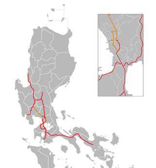
The North Luzon Expressway (NLEX), signed as E1 of the Philippine expressway network, partially as N160 of the Philippine highway network, and R-8 of the Metro Manila arterial road network, is a limited-access toll expressway that connects Metro Manila to the provinces of the Central Luzon region in the Philippines. The expressway, which includes the main segment and its various spurs, has a total length of 101.8 kilometers (63.3 mi) and travels from its northern terminus at Sta. Ines Interchange to its southern terminus in Balintawak Interchange, which is adjacent to its connection to Skyway, an elevated toll road that connects the NLEX to its counterpart in the south, the South Luzon Expressway. The segment of the expressway between Santa Rita Exit in Guiguinto and the Balintawak Interchange in Quezon City is part of Asian Highway 26 of the Asian highway network.

<span class="mw-page-title-main">Manila–Cavite Expressway</span> Expressway in the Philippines

The Manila–Cavite Expressway, signed as E3 of the Philippine expressway network and R-1 of Metro Manila's arterial road network, is a 14-kilometer-long (8.7 mi) controlled-access toll expressway linking Manila to the southern province of Cavite in the Philippines. At its north end, it feeds into and from Roxas Boulevard in the city of Parañaque in Metro Manila, also part of R-1. At the south end, it splits into two termini, both along the north coast in Kawit, Cavite. The first feeds into the intersection of Tirona Highway and Antero Soriano Highway. The second southern terminus is on the intersection of Tirona Highway, Antero Soriano Highway and Covelandia Road in Kawit, Cavite.

<span class="mw-page-title-main">Pan-Philippine Highway</span> Highway in the Philippines traversing most of the country

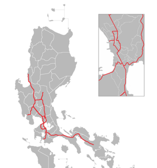
The Pan-Philippine Highway, also known as the Maharlika Highway, is a network of roads, expressways, bridges, and ferry services that connect the islands of Luzon, Samar, Leyte, and Mindanao in the Philippines, serving as the country's principal transport backbone. Measuring 3,379.73 kilometers (2,100.07 mi) long excluding sea routes not counted by highway milestones, it is the longest highway in the Philippines that forms the country's north–south backbone component of National Route 1 (N1) of the Philippine highway network. The entire highway is designated as Asian Highway 26 (AH26) of the Asian Highway Network.

<span class="mw-page-title-main">Metro Manila Skyway</span> Elevated expressway in Metro Manila, Philippines

The Metro Manila Skyway, officially the Metro Manila Skyway System (MMSS) or simply the Skyway, is an elevated highway which is the main expressway in Metro Manila, Philippines. It connects the North and South Luzon Expressways with access to Ninoy Aquino International Airport via the NAIA Expressway (NAIAX). It is the first fully grade-separated highway in the Philippines and one of the longest elevated highways in the world, with a total length of approximately 39.2 kilometers (24.4 mi).

<span class="mw-page-title-main">Port of Manila</span> Port in Philippines

The Port of Manila refers to the collective facilities and terminals that process maritime trade function in harbors in Metro Manila. Located in the Port Area and Tondo districts of Manila, Philippines, facing Manila Bay, it is the largest and the premier international shipping gateway to the country. The Philippine Ports Authority, a government-owned corporation, manages the Port of Manila and most of the public ports in the country. It is composed of 3 major facilities, namely Manila North Harbor, Manila South Harbor, and the Manila International Container Terminal.

<span class="mw-page-title-main">Tullahan River</span> River in the National Capital Region, Philippines

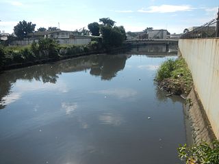
The Tullahan River is a river in the Philippines. It is located to the north of Manila and has an approximate length of 27.1 kilometers (16.8 mi). It starts at the La Mesa Reservoir in Quezon City and flows through Caloocan, Malabon, Valenzuela. and Navotas and empties into Manila Bay. In 2019, San Miguel Corporation pledges ₱1 billion for the cleanup of the Tullahan River as part of the Manila Bay rehabilitation effort.

<span class="mw-page-title-main">Circumferential Road 5</span> Road in the Philippines

Circumferential Road 5 (C-5), informally known as the C-5 Road, is a network of roads and bridges that all together form the fifth beltway of Metro Manila in the Philippines. Spanning some 43.87 kilometers (27.26 mi), it connects the cities of Las Piñas, Makati, Parañaque, Pasay, Pasig, Quezon City, Taguig, and Valenzuela.

<span class="mw-page-title-main">MacArthur Highway</span> Highway in Luzon

The MacArthur Highway, officially the Manila North Road, is a 684.855-kilometer (425.549 mi), two-to-six lane, national primary highway and tertiary highway in Luzon, Philippines, connecting Caloocan in Metro Manila to Aparri in Cagayan at the north. It is the second longest road in the Philippines, after Maharlika Highway. It is primarily known as MacArthur Highway in segments from Caloocan to Urdaneta, Pangasinan, although it is also applied up to Ilocos Sur, and likewise called as Manila North Road for the entire length.

<span class="mw-page-title-main">Radial Road 8</span>

Radial Road 8, more commonly referred to as R-8, is a network of roads and bridges that altogether form the eighth radial road of Manila in the Philippines. It runs north-south through northern Metro Manila linking the City of Manila with Quezon City, Caloocan, and Valenzuela into the northern provinces of Bulacan, Pampanga, Tarlac, Pangasinan, and La Union. The portion of R-8 between Guiguinto and Balintawak is also designated a component of the Pan-Philippine Highway network (AH26). It also has a spur segment in Quirino Highway from NLEX to its junction with R-7 at Commonwealth Avenue, both in Quezon City.

<span class="mw-page-title-main">Circumferential Road 3</span> Third beltway of Metro Manilas highways

Circumferential Road 3 (C-3), informally known as the C-3 Road, is a network of roads and bridges that all together form the third beltway of Metro Manila in the Philippines. Spanning some 14.93 kilometers (9.28 mi), it connects the cities of Caloocan, Makati, Navotas, Pasay, Quezon City, and San Juan.

<span class="mw-page-title-main">Mindanao Avenue</span> Major thoroughfare from Caloocan to Quezon City, Philippines

Mindanao Avenue is an eight-to-ten lane divided avenue connecting EDSA and NLEX and is a part of Circumferential Road 5 (C-5) in Metro Manila, Philippines. It is one of the three parallel roads that connects Tandang Sora and Congressional Avenues ; that is why it was named after the southernmost mainland of the Philippines, Mindanao. It used to be a 2-kilometer (1.2 mi) highway connecting North Avenue and Congressional Avenue, but as a part of the C-5 projects, Mindanao Avenue was extended to EDSA in the south and to Quirino Highway to the north. The new roads opened in 2000.

<span class="mw-page-title-main">Radial Road 10</span>

Radial Road 10, more commonly referred to as R-10, is a planned network of roads and bridges that all together would form the tenth radial road of Manila in the Philippines. It is the westernmost of the radial roads north of the Pasig River running north–south close to the shoreline of Manila Bay. When completed, the road would link the City of Manila with Navotas, and the northern coastal provinces of Bulacan, Pampanga, and Bataan in Central Luzon.

<span class="mw-page-title-main">Maysan Road</span>

Maysan Road is one of the main east–west thoroughfares of Valenzuela, Philippines. It is a narrow street with only one lane in each direction making it one of the most congested streets in northern Metro Manila. It runs for approximately 4.5 kilometers (2.8 mi) from MacArthur Highway in barangay Malinta, past the North Luzon Expressway intersection, into North Caloocan. The road connects the central Valenzuela barangays of Malinta, Maysan, Paso de Blas, and Bagbaguin. It was the main access road for vehicles going to Valenzuela and the Manila North Harbor from the North Luzon Expressway prior to the construction of NLEX Segment 9, which parallels it to the south.

<span class="mw-page-title-main">Harbor Link Interchange</span> Major intersection in Valenzuela, Metro Manila

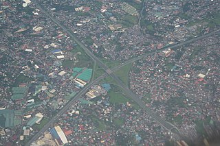
The Harbor Link Interchange, also known as the Mindanao Interchange and North Luzon Expressway Harbor Link Interchange and formerly known as the Smart Connect Interchange, is a two-level cloverleaf interchange in Valenzuela, Metro Manila, the Philippines which serves as the junction of North Luzon Expressway (NLEX) between its main segment and its Harbor Link project, particularly Segments 8.1 and 9, components of Circumferential Road 5 (C-5). Built as part of the 2.7-kilometer (1.7 mi) NLEX Segment 8.1 of the Harbor Link project extending the expressway to Mindanao Avenue, which has since been incorporated into the C-5 system, it is the Philippines' largest cloverleaf interchange in terms of land area.

<span class="mw-page-title-main">Philippine expressway network</span> Expressway system in the Philippines

The Philippine expressway network, also known as the High Standard Highway Network, is a controlled-access highway network managed by the Department of Public Works and Highways (DPWH) which consists of all expressways and regional high standard highways in the Philippines.

National Route 1 (N1) is a primary national route that forms part of the Philippine highway network, running from Luzon to Mindanao. Except for a 19-kilometer (12 mi) gap in Metro Manila and ferry connections, the highway is generally continuous. Most sections of N1 forms the Pan-Philippine Highway except for sections bypassed by expressways.

<span class="mw-page-title-main">E1 expressway (Philippines)</span>

Expressway (E1) forms part of the Philippine expressway network. It runs through western Luzon from Quezon City in the south to Rosario in the north.

<span class="mw-page-title-main">NLEX Connector</span> Elevated highway in the Philippines

NLEX Connector, also known as the NLEX–SLEX Connector Road, is a 7.7-kilometer (4.8 mi), four-lane elevated expressway in Metro Manila, Philippines. It connects the NLEX Harbor Link to the Metro Manila Skyway, which in turn connect to the North and South Luzon Expressways, respectively, while traversing parallel to the PNR Metro Commuter Line. The highway has five interchanges, three of which is currently operational. Alongside NLEX Harbor Link, trucks are allowed to use it.

References

  1. "2015 DPWH Road Data". Department of Public Works and Highways . Retrieved March 5, 2018.
  2. 1 2 3 "NLEX HARBOR LINK PROJECT (Segments 8.1, 8.2, 9 & 10)". Department of Public Works and Highways. Retrieved July 17, 2021.
  3. "MNTC starts construction of roads connecting NLEX from all directions". GMA News and Public Affairs. April 2, 2009. Retrieved July 8, 2016.
  4. "NLEX's Segment 8.1 opens today, June 5" (Press release). Manila North Tollways Corporation. June 5, 2010. Archived from the original on June 20, 2010. Retrieved July 8, 2016.
  5. "PGMA inaugurates P2.1-B NLEX-Mindanao Avenue Link". Philippines News Agency. June 5, 2010. Archived from the original on November 19, 2011. Retrieved July 8, 2016.
  6. Reyes, Mary Ann L.L. (July 12, 2015). "Seamless travel". The Philippine Star . PhilStar Daily, Inc. Retrieved July 8, 2016.
  7. Mangunay, Kristine Felisse; Montecillo, Paolo G. (February 13, 2013). "NLEx Harbor Link expressway breaks ground; new road seen to ease Metro traffic". Philippine Daily Inquirer.
  8. "NLEX concessionaire breaks ground for Harbor Link Segment 10". TopGear Philippines. March 4, 2014.
  9. "Duterte leads inauguration of NLEX Harbor Link Segment 10, groundbreaking of NLEX Connector". NLEX Corporation . February 28, 2019. Retrieved May 11, 2021.
  10. Laurel, Drei (March 1, 2019). "NLEX Harbor Link Segment 10 is finally open". Top Gear Philippines. Retrieved May 11, 2021.
  11. Manabat, Jacque (July 21, 2015). "MNTC eyes completing NLEX-Harbor Link by Dec 2016". ABS-CBN News. Retrieved May 11, 2021.
  12. Rey, Aika (February 22, 2020). "NLEX Harbor Link Malabon Exit open to motorists". Rappler. Retrieved May 22, 2020.
  13. "NLEX opens latest Harbor Link section". CNN Philippines. June 15, 2020. Retrieved June 15, 2020.
  14. 1 2 3 4 "Concessions". NLEX Corporation. Retrieved May 22, 2020.
  15. Mercurio, Richmond (March 2, 2020). "NLEX keen on Port Expressway Link project". The Philippine Star. Retrieved May 18, 2020.
  16. Mercurio, Richmond (February 14, 2020). "Construction to start soon on Harbor Link extension". The Philippine Star. Retrieved May 18, 2020.
  17. "FIRST QUARTER 2021 FINANCIAL AND OPERATIONAL RESULTS ANALYSTS' BRIEFING" (PDF). Metro Pacific Investments Corporation. May 5, 2021. Retrieved June 27, 2021.
  18. 1 2 "Environmental Impact Statement (EIS) Summary for the Public in English NLEX-C5 (Segment 8.2) North Link Project" (PDF). Environmental Impact Assessment and Management Division. March 2021. Retrieved July 17, 2021.
  19. "Road and Bridge Inventory". www.dpwh.gov.ph. Retrieved June 14, 2020.
  20. "MNTC | Projects". Manila North Tollways Corporation. Archived from the original on September 14, 2018. Retrieved September 14, 2018.
  21. "Silip sa Sauyo at Proyektong NLEX 8.2". Manila Today (in Filipino). September 4, 2018. Retrieved September 27, 2020.
  22. "Right of way issue delays NLEX segment". The Manila Times. June 8, 2015. Retrieved July 18, 2021.
  23. Balinbin, Arjay L. (February 19, 2020). "DPWH readies NLEx 'Segment 8.2'". BusinessWorld. Retrieved July 18, 2021.
  24. Tuquero, Loreben (November 12, 2019). "House panel wants in-city relocation for 18k informal settlers along QC's Segment 8.2". Rappler. Retrieved July 18, 2021.
  25. Balinbin, Arjay L. (July 19, 2021). "NLEX targets to start P2-B QC extension by early Sept". BusinessWorld. Retrieved July 19, 2021.
  26. "NLEX-C5 (Segment 8.2) North Link Project" (PDF). Environmental Impact Assessment and Management Division. August 2019. Retrieved September 27, 2020.
  27. "NLEX Harbor Link C3-R10 Section Progress Video (as of June 1, 2020)". YouTube . June 1, 2020.
  28. 1 2 Patinio, Ferdinand (June 15, 2020). "NLEX Harbor Link C3-R10 section now open to motorists". Philippine News Agency.