National Register of Historic Places listings in Apostle Islands National Lakeshore

Last updated

This is a list of the National Register of Historic Places listings in Apostle Islands National Lakeshore.

Contents

This is intended to be a complete list of the properties and districts on the National Register of Historic Places in Apostle Islands National Lakeshore, Wisconsin, United States. The locations of National Register properties and districts for which the latitude and longitude coordinates are included below, may be seen in a Google map. [1]

There are thirteen properties and districts listed on the National Register in the park.


    This National Park Service list is complete through NPS recent listings posted August 11, 2023. [2]

Map all coordinates using: OpenStreetMap

Current listings

[3] Name on the RegisterImageDate listed [4] Location City or townDescription
1 Apostle Islands Lighthouses
Apostle Islands Lighthouses Mich2000.jpg
Apostle Islands Lighthouses
March 8, 1977
(#77000145)
N and E of Bayfield on Michigan, raspberry, Outer, Sand and Devils Islands
46°59′38″N90°36′06″W / 46.993889°N 90.601667°W / 46.993889; -90.601667 (Apostle Islands Lighthouses)
Bayfield
2 Bass Island Brownstone Company Quarry
Bass Island Brownstone Company Quarry Basswood Island Wisconsin Brownstone Company Quarry Path.jpg
Bass Island Brownstone Company Quarry
March 29, 1978
(#78000075)
N of La Pointe on Basswood Island
46°49′56″N90°45′20″W / 46.832222°N 90.755556°W / 46.832222; -90.755556 (Bass Island Brownstone Company Quarry)
La Pointe
3 Hadland Fishing Camp
Hadland Fishing Camp Rocky Island Hadland Fishing Camp.jpg
Hadland Fishing Camp
August 18, 1977
(#77000146)
N of La Pointe on Rocky Island
47°02′38″N90°39′57″W / 47.043889°N 90.665833°W / 47.043889; -90.665833 (Hadland Fishing Camp)
La Pointe
4 Hokenson Fishing Dock
Hokenson Fishing Dock ApostleIslandNationalLakeshoreWI-033-050507.jpg
Hokenson Fishing Dock
June 18, 1976
(#76000050)
N of Bayfield at Little Sand Bay
46°56′48″N90°53′29″W / 46.946667°N 90.891389°W / 46.946667; -90.891389 (Hokenson Fishing Dock)
Bayfield
5 La Pointe Light Station
La Pointe Light Station Longlite.jpg
La Pointe Light Station
August 4, 1983
(#83003366)
Long Island in Chequamagon Bay
46°43′43″N90°47′06″W / 46.728666°N 90.785108°W / 46.728666; -90.785108 (La Pointe Light Station)
Bayfield Light on 65 foot skeletal tower, started in 1895 to guide ore freighters between the islands. The WPA added the lightkeeper's house in 1939. [5]
6 Manitou Camp
Manitou Camp Manitou Island Camp.jpg
Manitou Camp
January 19, 1983
(#83003367)
Manitou Island
46°57′20″N90°40′35″W / 46.955556°N 90.676389°W / 46.955556; -90.676389 (Manitou Camp)
Apostle Islands National Lakeshore
7 Morty Site (47AS40)
Morty Site (47AS40) Address restricted.PNG
Morty Site (47AS40)
June 13, 1988
(#88000145)
Address Restricted
Bayfield
8 P-Flat Site (47AS47)
P-Flat Site (47AS47) Address restricted.PNG
P-Flat Site (47AS47)
September 19, 1988
(#88000144)
Address Restricted
Bayfield
9 Rocky Island Historic District
Rocky Island Historic District Rocky Island Historic District Wisconsin.jpg
Rocky Island Historic District
July 3, 2008
(#08000016)
Rocky Island, Apostle Islands National Lakeshore
47°02′45″N90°39′58″W / 47.045833°N 90.666111°W / 47.045833; -90.666111 (Rocky Island Historic District)
La Pointe vicinity
10 Sevona Cabin September 29, 1976
(#76000051)
N of Bayfield on Sand Island
46°57′49″N90°56′14″W / 46.963611°N 90.937222°W / 46.963611; -90.937222 (Sevona Cabin)
Bayfield
11 Shaw Farm June 18, 1976
(#76000052)
Sand Island
46°57′47″N90°56′03″W / 46.963056°N 90.934167°W / 46.963056; -90.934167 (Shaw Farm)
Bayfield
12 Trout Point Logging Camp
Trout Point Logging Camp Address restricted.PNG
Trout Point Logging Camp
December 16, 1988
(#88002756)
Address Restricted
Bayfield
13 West Bay Club July 28, 2015
(#14000385)
Sand Island
46°58′19″N90°58′35″E / 46.971993°N 90.976478°E / 46.971993; 90.976478 (West Bay Club)
Bayfield

See also

Related Research Articles

<span class="mw-page-title-main">National Register of Historic Places listings in the Bronx</span>

List of Registered Historic Places in Bronx County, New York :

<span class="mw-page-title-main">National Register of Historic Places listings in Brooklyn</span>

The following properties are listed on the National Register of Historic Places in Brooklyn.

<span class="mw-page-title-main">National Register of Historic Places listings in Staten Island</span>

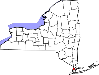
List of the National Register of Historic Places listings in Richmond County, New York.

<span class="mw-page-title-main">National Register of Historic Places listings in Scott County, Iowa</span>

This is intended to be a complete list of the properties and districts on the National Register of Historic Places in Scott County, Iowa, United States. Latitude and longitude coordinates are provided for many National Register properties and districts; these locations may be seen together in a map.

<span class="mw-page-title-main">National Register of Historic Places listings in Hillsborough County, Florida</span>

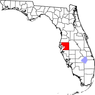
This is a list of the National Register of Historic Places listings in Hillsborough County, Florida.

<span class="mw-page-title-main">National Register of Historic Places listings in Bristol County, Rhode Island</span>

This is a list of the National Register of Historic Places listings in Bristol County, Rhode Island.

<span class="mw-page-title-main">National Register of Historic Places listings in Washington County, Rhode Island</span>

This is a list of the National Register of Historic Places listings in Washington County, Rhode Island.

This is intended to be a complete list of properties and districts listed on the National Register of Historic Places on Manhattan Island below 14th Street, which is a significant portion of the New York City borough of Manhattan. In turn, the borough of Manhattan is coterminous with New York County, New York. For properties and districts in other parts of Manhattan Island, the mainland neighborhood of Marble Hill, and the other islands of New York County, see National Register of Historic Places listings in Manhattan. The locations of National Register properties and districts may be seen in an online map by clicking on "Map of all coordinates".

This is intended to be a complete list of properties and districts listed on the National Register of Historic Places on Manhattan Island, the primary portion of the New York City borough of Manhattan, from 14th to 59th Streets. For properties and districts in other parts of Manhattan, whether on Manhattan Island, other islands within the borough, or the neighborhood of Marble Hill on the North American mainland, see National Register of Historic Places listings in Manhattan. The locations of National Register properties and districts may be seen in an online map by clicking on "Map of all coordinates".

This is intended to be a complete list of properties and districts listed on the National Register of Historic Places between 59th and 110th Streets in Manhattan. For properties and districts in other parts of Manhattan and the other islands of New York County, see National Register of Historic Places listings in Manhattan. The locations of National Register properties and districts may be seen in an online map by clicking on "Map of all coordinates".

List of the National Register of Historic Places listings in Manhattan above 110th Street

This is intended to be a complete list of historic properties and districts listed on the National Register of Historic Places located on islands other than Manhattan Island but still in New York County, New York. For all properties and districts in the borough of Manhattan, see National Register of Historic Places listings in New York County, New York. The locations of National Register properties and districts may be seen in an online map by clicking on "Map of all coordinates".

<span class="mw-page-title-main">National Register of Historic Places listings in Ashland County, Wisconsin</span>

This is a list of the National Register of Historic Places listings in Ashland County, Wisconsin. It is intended to provide a comprehensive listing of entries in the National Register of Historic Places that are located in Ashland County, Wisconsin. The locations of National Register properties for which the latitude and longitude coordinates are included below may be seen in a map.

<span class="mw-page-title-main">National Register of Historic Places listings in Charles City County, Virginia</span>

This is a list of the National Register of Historic Places listings in Charles City County, Virginia.

<span class="mw-page-title-main">National Register of Historic Places listings in Marinette County, Wisconsin</span>

This is a list of the National Register of Historic Places listings in Marinette County, Wisconsin. It is intended to provide a comprehensive listing of entries in the National Register of Historic Places that are located in Marinette County, Wisconsin. The locations of National Register properties for which the latitude and longitude coordinates are included below may be seen in a map.

<span class="mw-page-title-main">National Register of Historic Places listings in Orleans Parish, Louisiana</span>

The following properties are listed on the National Register of Historic Places in Orleans Parish, Louisiana. Orleans Parish is synonymous with the city of New Orleans.

<span class="mw-page-title-main">National Register of Historic Places listings in Bayfield County, Wisconsin</span>

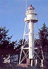
This is a list of the National Register of Historic Places listings in Bayfield County, Wisconsin. It is intended to provide a comprehensive listing of entries in the National Register of Historic Places that are located in Bayfield County, Wisconsin. The locations of National Register properties for which the latitude and longitude coordinates are included below may be seen in a map.

<span class="mw-page-title-main">National Register of Historic Places listings in Douglas County, Wisconsin</span>

This is a list of the National Register of Historic Places listings in Douglas County, Wisconsin. It is intended to provide a comprehensive listing of entries in the National Register of Historic Places that are located in Douglas County, Wisconsin. The locations of National Register properties for which the latitude and longitude coordinates are included below may be seen in a map.

This is a list of the National Register of Historic Places listings in Acadia National Park.

This is a list of the National Register of Historic Places listings in Sleeping Bear Dunes National Lakeshore.

References

  1. The latitude and longitude information provided in this table was derived originally from the National Register Information System, which has been found to be fairly accurate for about 99% of listings. Some locations in this table may have been corrected to current GPS standards.
  2. National Park Service, United States Department of the Interior, "National Register of Historic Places: Weekly List Actions", retrieved August 11, 2023.
  3. Numbers represent an alphabetical ordering by significant words. Various colorings, defined here, differentiate National Historic Landmarks and historic districts from other NRHP buildings, structures, sites or objects.
  4. The eight-digit number below each date is the number assigned to each location in the National Register Information System database, which can be viewed by clicking the number.
  5. Pepper, Terry. "New La Pointe Light Station". Seeing the Light. Terry Pepper. Retrieved February 21, 2013.