Naya Raipur

Last updated

Naya Raipur
Atal Nagar-Naya Raipur
Naya Raipur, Sector 19.png
Mantralaya Naya Raipur (Atal Nagar).png
Avinash Times Square mall, Naya Raipur.png
Musical fountain, In sector 19 Atal Nagar , Naya Raipur.png
IIIT Naya Raipur 1.jpg
Swagat Vatika, Cloverleaf interchange Naya Raipur, (Atal Nagar).png
Sri Sathya Sai temple , Naya Raipur.png
Office complex block A & B , sector 24, Naya Raipur.png
From top, left to right: Capitol Complex, Secretariat Chhattisgarh, Avinash Times Square Mall, Musical fountain, International Institute of Information Technology, Naya Raipur, Indian Institute of Management Raipur, Hidayatullah National Law University, Swagat Vatika Cloverleaf interchange, CBD sector 21, Satya Sai temple, Mantralaya Lake
Naya Raipur
Interactive map of Naya Raipur
India Chhattisgarh location map.svg
Red pog.svg
Naya Raipur
Location in Chhattisgarh, India
India location map.svg
Red pog.svg
Naya Raipur
Naya Raipur (India)
Coordinates: 21°09′40″N81°47′13″E / 21.161°N 81.787°E / 21.161; 81.787
CountryIndia
State Chhattisgarh
District Raipur
Government
  Body Nava Raipur Atal Nagar Vikas Pradhikaran
Population
  Total560,000
Languages
  Official Hindi
Time zone UTC+5:30 (IST)
Telephone code+91-0771
Vehicle registration CG 04
Nearest city Raipur, Bhilai, Durg
Lok Sabha constituency Raipur (Lok Sabha constituency)
Civic agency Nava Raipur Atal Nagar Vikas Pradhikaran
Website https://navaraipuratalnagar.com

Naya Raipur, officially known as Atal Nagar-Nava Raipur, [1] is a planned city and fully Greenfield city in Indian state of Chhattisgarh. It is planned to replace Raipur as the capital city of Chhattisgarh. [2] [3] The Government of Chhattisgarh, the state's administrative body is situated here. The city is located between National Highway 53 and National Highway 30, about 17 km south-east of the capital city Raipur. Swami Vivekananda Airport separates Raipur and Nava Raipur.

Contents

After the formation of the new state of Chhattisgarh in November 2000, the state government decided to create a well planned new city for Raipur. Hence a special area has been notified under section 64 of Nagar Tatha Gramnivesh Adhiniyam 1973.

The authority thus formed is the Capital Area Development Authority (CADA) which is now called the Atal Nagar Vikas Pradhikaran (NRDA). NRDA is the nodal agency undertaking comprehensive development of this 'greenfield' city.

Chief executive officers are appointed by government and other officers and staff working under NRDA organisation. [4] Indian Administrative Service (IAS) officer P. Joy Oommen is the chairman of the NRDA, while Amit Kataria is its chief executive. [5]

Economic base

The main activity base of Naya Raipur would be the government/state capital functions. However, a diversification of economy is desirable, which would be attained through the following activities: [6]

Planning methodology

While venturing to prepare the development plan for Naya Raipur, basic studies were made in the form of a secondary survey of data on Chandigarh (the first planned capital of a state in independent India) and Raipur, the elder sister and the most important "organic" metropolis in the region.

The space quantum against each activity/work-centre was then ascertained going by the accepted thumb-rule of the concerned industry/trade/activity, to the case of capital complex, and exact figures of government jobs were taken into consideration. The resultant space quantum was then allocated on two-dimension on the structure plan and final quantum, shape, location, was defined by exact boundaries/roads on the plan.

With iterations, the allocated spaces were again translated in terms of number of jobs and the total number of job in the city arrived at. With a population of 5.6 lakhs, the Naya Raipur City will be expected to generate approximately 2.2 lakh jobs, with an assumed workforce participation rate of 40%. The high standards of physical and social infrastructure adopted for the city will be able to cope with the maximum capacity of the city. [7]

Education

Hidayatullah National Law University Academic block, Hidayatullah National Law University.jpg
Hidayatullah National Law University

Naya Raipur will form the hub of educational institutions in the state. The city will have premier educational institutions shifted from Raipur. A few of them are:

Transportation

Roadways

Naya Raipur has an entirely planned road network within the city premises, and is having good connectivity with Raipur and the rest of the state, with the help of national and state highways. Some of the major roads are Raipur–Naya Raipur Expressway, or the Atal Path Expressway, which directly connects the city with Raipur railway station, National Highway 30 (NH-30 as a secondary highway to Raipur and National Highway 53 (NH-53), which passes through just north of the city.

The proposed Durg–Raipur–Arang Expressway will pass through the southern limits of the city, and the under-construction Raipur–Visakhapatnam Expressway will start from Kurud, which is 41 km (25 mi) south of the city, and could be accessed with the help of NH-30. Once both the expressways are completed, it will help the city by enhancing connectivity and commute with the state, as well as with the rest of the country.

Rail

There are two small railway stations in proximity to the city, and the main and nearest railway station is the Naya Raipur Railway Station or Atal Nagar Railway Station, which is located 11 km (6.8 mi) north of the city, lying on the Howrah–Nagpur–Mumbai line passing through the northern limits of the city. [11] The major railway stations are Raipur Junction railway station, 25 km (16 mi) and Arang Mahanadi railway station located at Arang, 24 km (15 mi) from Naya Raipur, respectively.

To the east of the airport, in the Central Business District, a bypass line has been made to connect the city directly by making a new, major railway station for Naya Raipur. It is named as the CBD Railway Station, and is under construction. Once completed, it will become the main railway station for the city. [12]

Bus transport

Raipur and Naya Raipur Bus Rapid Transit System Raipur-Naya Raipur BRTS.png
Raipur and Naya Raipur Bus Rapid Transit System

Regular bus services are operated by the Nava Raipur Atal Nagar Vikas Pradhikaran, government and private operators from the main bus station of Naya Raipur Bus Station, and along with these services, the Raipur and Naya Raipur Bus Rapid Transit System also connects the city with Raipur. The BRTS has currently 9 stops in the city, as part of the first phase of the smart city project, which in the future will be expanded in the coming phases.

Metro

A light rail, Metrolite or Lite Metro (as referred in India), has been proposed by the Government of Chhattisgarh, which will start from Naya Raipur to Durg via Raipur and Bhilai. [13]

Air

Swami Vivekananda Airport, Raipur Swami vivekananda Airport terminal Raipur. Night view.jpg
Swami Vivekananda Airport, Raipur

The nearest airport is Swami Vivekananda Airport, the only major airport of Chhattisgarh, lies within the city premises of the city, in its western outskirts, 10 km (6.2 mi) from the centre. The airport is well-connected, having daily direct flights to Mumbai, Delhi, Visakhapatnam, Kolkata, Bangalore, Pune, Chennai, Goa, Lucknow, Indore, Ahmedabad, Bhopal, Bhubaneswar, Nagpur, Hyderabad, Prayagraj, and Jagdalpur, operated by Alliance Air, IndiGo and Vistara airlines. [14]

Sports

Shaheed Veer Narayan Singh International Cricket Stadium is a recently constructed cricket stadium in the city. It was opened in 2008, and has a capacity to handle 65,000 spectators. It is the second largest cricket stadium in India and the fourth largest cricket stadium in the world by seating capacity.

The stadium was home ground for two matches for the Indian Premier League (IPL) team, Delhi Daredevils, during the 2013, 2015 and 2016 events.

The stadium hosted a half marathon, with the theme "Let Us Run" on 16 December 2012 to mark Vijay Diwas. [15]

See also

Related Research Articles

<span class="mw-page-title-main">Raipur</span> Metropolis in Chhattisgarh, India

Raipur ( ) is the capital city of the Indian state of Chhattisgarh. Raipur is also the administrative headquarters of Raipur district and Raipur division, and the largest city of the state. It was a part of Madhya Pradesh before the state of Chhattisgarh was formed on 1 November 2000. It is a major commercial hub for trade and commerce in the region. It has exponential industrial growth and has become a major business hub in Central India. It has been ranked as India's 6th cleanest city as per the Swachh Survekshan for the year 2021. Raipur is ranked 7th in the Ease of Living Index 2019 and 7th in the Municipal Performance Index 2020, both by the Ministry of Housing and Urban Affairs (MoHUA).

<span class="mw-page-title-main">Ambikapur, Chhattisgarh</span> City in Chhattisgarh, India

Ambikapur is a city and headquarters of Surguja district in the Indian state of Chhattisgarh. It is one of the oldest cities in the state, in east-central India. Ambikapur is also the divisional headquarters of Surguja Division which consists of the six districts of Surguja, Korea, Manendragarh, Balrampur, Surajpur and Jashpur.

Rajnandgaon is a city in Rajnandgaon District, in the state of Chhattisgarh, India. As of the 2011 census the population of the city was 163,122. Rajnandgaon district came into existence on 26 January 1973, as a result of the division of Durg district.

<span class="mw-page-title-main">Bilaspur, Chhattisgarh</span> Metropolis in Chhattisgarh, India

Bilaspur, also known as "The City of Festivals", is a city located in Bilaspur District in the Indian state of Chhattisgarh. Bilaspur is the Administrative headquarters of the Bilaspur District and Bilaspur Division. The Chhattisgarh High Court, located at Bodri, District Bilaspur has privileged it with the title Nyayadhani of the State. This city is the commercial center and business hub of North East Chhattisgarh region. It is also an important city for the Indian Railways, as it is the headquarters for South East Central Railway Zone (SECR) and the Bilaspur Railway Division. Bilaspur is also the headquarters of South Eastern Coalfields Limited. Chhattisgarh biggest power plant operated by NTPC is in Sipat. PowerGrid in Sipat pools electricity from other power plants in region and transmits electricity to Delhi via one of longest HVDC line.

<span class="mw-page-title-main">Korba, Chhattisgarh</span> Power City of Chhattisgarh, India

Korba is a city and an industrial area in Korba District in the Indian state of Chhattisgarh. Korba was erstwhile part of Bilaspur District before 25 May 1998 later that Korba was made a separate District for ease of administration but it is still under Bilaspur Division. Korba is called power capital of Chhattisgarh due to its Coal reserves and Industrial base for multiple thermal based power plants from Public sector like NTPC Limited, CSEB from State of Chhattisgarh as well as from private sector apart from Power plants Korba has the Asia's second largest and India's largest open cast coal mine in Gevra area of Korba Coalfield. Korba produces 140 Million tons of coal every year which accounts for 17% of Country's total coal production and 85% of Chhattisgarh Coal production. BALCO Private owned Aluminium producer has its smelter Aluminium Plant in Korba. Here mainly the protected tribal tribe Korwa resides. Korba district is blessed by lush green forests from all around, a large population of tribals is found here. The tribals here prefer to live in harmony with the environment in the forest area due to which they have retained their distinctive cultural characteristics and traditional practices.

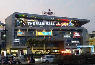
Mahasamund is a city in Mahasamund District in the Indian state of Chhattisgarh.It is situated on the Mumbai-Kolkata and Raipur-Vishakhaptnam National Highways. It is one of the largest and most important cities in the State. The city is divided into 30 wards and 5 zones and is also the biggest city in the Trans-Mahanadi area. It is also the administrative headquarters of the Mahasamund District and part of the proposed new Mahasamund Municipal Corporation. The current mayor is Prakash Chandrakar. Reliance Trends, Vishal Megamart, Reliance Jio Smart Point, B mart and Zee Sale are prominent Shopping Centers of the City.

<span class="mw-page-title-main">Surajpur, Chhattisgarh</span> City in Chhattisgarh, India

Surajpur is a Nagar Palika Parishad situated in the bank of Rihand River in Surajpur district of Chhattisgarh state in Central India. It is the administrative headquarters of the Surajpur district, located 334 km away from the state's capital city, Raipur. The National Highway 43 has its route through Surajpur.

<span class="mw-page-title-main">Arang</span> Place in India

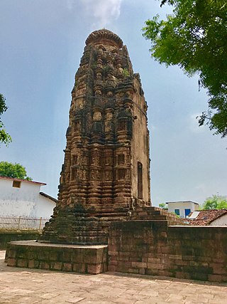
Arang, also known as "The town of temples" of Chhattisgarh, is a block and a Nagar Palika in Raipur District in the state of Chhattisgarh, India. It is situated near the eastern limits of Raipur City and close to Mahasamund City. Arang is an ancient town, which was ruled by the Haihayas Rajput dynasty. It is famous for its many Jain and Hindu temples which belong to the 11th and 12th centuries; these are the Mand Deval Jain temple, the Mahamaya temple, the Panchmukhi temple and the Hanuman temple. Due to the Archaeological finds of a copper plate inscription dated to the Gupta Empire, known as the Arang Plate of Bhimasena II of the clan of Rajarsitulya, has established the town's ancient history as a Hindu and Jain religious centre, which was then under the rule of Hindu kings. The Mand Deval Jain temple is the most ancient of these temples dated to the 11th century where three huge images of Digambara tirthankaras are deified in the sanctum sanctorum; these are carved in black stone and polished.

National Highway 6 & Economic Corridor 1 (EC1), was a National Highway in India that has been separately designated under the new national highway numbering system. It was officially listed as running over 1,949 km (1,211 mi)from Surat to Kolkata. The route was also known as Asian Highway 46 (AH46) & Mumbai - Kolkata Highway and Great Eastern Highway.

The Western Peripheral Expressway (WPE) or Kundli–Manesar–Palwal Expressway, is an operational 6-lane, 135.6 km (84.3 mi)-long Expressway in the Haryana state of India. Along with the Eastern Peripheral Expressway, the Western Peripheral Expressway is expected to divert more than 50,000 heavy vehicles away from Delhi, which will help to maintain good air quality in Delhi. Western Peripheral Expressway along with Eastern Peripheral Expressway completes the largest Ring Road around Delhi. There are 10 tolled entries and exits, from north to south - Kundli, Kharkhoda, Bahadurgarh, Badli, Fartukhnagar, Panchgaon, Manesar, Taoru, Sohna & Palwal. Toll rate notified in December 2018 is INR1.35 per km for cars, INR2.18 per km for light motor vehicles, INR4.98 per km for trucks and buses, and two wheelers are not permitted on the expressway.

Abhanpur is a tehsil in Raipur district, Chhattisgarh, India. It is a part of the Naya Raipur township.

<span class="mw-page-title-main">Bhilai</span> City in Chhattisgarh

Bhilai is a city in Durg district of the Indian state of Chhattisgarh, in eastern central India. Along with its twin-city Durg, the urban agglomeration of Durg-Bhilainagar has a population of more than a million, making it the second-largest urban area in Chhattisgarh after Raipur. Bhilai is a major industrial city as well as an education hub of central India. The Bhilai metropolis contains three municipal corporations: Bhilai Municipal Corporation, Bhilai-Charoda Municipal Corporation and Risali Municipal Corporation.

Pandatarai is a town & nagar panchayat in the Kabirdham district of Chhattisgarh, India. This is a religious and tourist site. In Pandatarai temple of Maa Mahamaya (durga) and a historical temple of lord Shivajaleshwar mahadev dongariya is near about Pandatarai and dargahe auliya sher shah vali are most popular places. Dongariya mahadev is also papular destination Pandatarai Pin code is 491559 and postal head office is Pandaria.

Raipur–Bhilai–Durg or Durg-Bhilai-Raipur Expressway is a 27-kilometre-long (17 mi) high-speed urban expressway which links Raipur- Bhilai and Durg on Asian Highway 46 (India) (AH-46) in the state of Chhattisgarh. The expressway also connects Chhattisgarh with Visakhapatnam, one of the most important ports of India. The expressway has two toll stations installed, one at Kharun - at the entry point of the expressway from Raipur and the other at Kutelabhata - at the exit point of the expressway towards Bhilai.

<span class="mw-page-title-main">Shaheed Veer Narayan Singh International Cricket Stadium</span> Cricket stadium

The Shaheed Veer Narayan Singh International Cricket Stadium Raipur, also known as Nava Raipur International Cricket Stadium, is a cricket arena in the city of Naya Raipur, Chhattisgarh, India. The Cricket Stadium is India's 50th international cricket venue. First International cricket match played here was an ODI between India and New Zealand in 2023, which was won by India. This state-of-the-art cricket stadium hosts domestic and international cricket matches. It is the largest sports stadium in Central India.

Telibandha railway station was a narrow gauge railway station in Raipur district, Chhattisgarh. Its code was TBD. It served Raipur city. The station consisted of one platform. The station lied on the former Raipur–Dhamtari branch line of Bilaspur–Nagpur section.

Antagarh is a town and a Nagar Panchayat located in the Kanker district of Chhattisgarh, India. It is the administrative headquarters of its eponymous development block, tehsil, and Assembly constituency.

Raipur–Visakhapatnam Expressway (NH-130CD), part of Raipur–Visakhapatnam Economic Corridor (EC-15), is an under-construction, six-lane, 464 km (288 mi) long access-controlled greenfield expressway, which will pass through the states of Chhattisgarh, Odisha and Andhra Pradesh in central and east-central India. At present, from Durg, it runs between NH-30 and NH-130C till Boriguma, then runs east of NH-26 till Sunabeda and then west of NH-26 till Visakhapatnam after terminating with NH-16 at Vizianagaram. Along the new route, it will connect Raipur by starting at Abhanpur in Raipur district with the cities of Dhamtari, Kanker, Kondagaon, Koraput, and Sabbavaram before terminating at Visakhapatnam Port.

Durg–Raipur–Arang Expressway is a planned 92 km (57 mi) long, six-lane, access-controlled greenfield expressway in the state of Chhattisgarh, India. The expressway is a part of Bharatmala Pariyojana, and will pass from Durg through Anjora, Patora, Supkona, Abhanpur and Naya Raipur before terminating at Arang.

References

  1. "Naya Raipur renamed Nava Raipur". Daily Pioneer. 2019.
  2. Mary N. Woods (2016). Women Architects in India: Histories of Practice in Mumbai and Delhi. Taylor & Francis. p. 195. ISBN   978-1-134-77422-7. Naya Raipur, a city planned for 500,000 residents on 11,000 acres, must embody government aspirations for the entire state. It will replace the polluted, antiquated, and overcrowded old capital of Raipur.
  3. "History of Atal Nagar". Atal Nagar Vikas Pradhikaran. Retrieved 26 May 2019. Atal Nagar, as the name suggests, is the new upcoming state capital of Chhattisgarh.
  4. "Naya Raipir Development Authoritiy | About". Archived from the original on 6 April 2009. Retrieved 12 August 2009.
  5. "Naya Raipir Development Authoritiy | Organization setup". Archived from the original on 7 October 2008. Retrieved 12 August 2009.
  6. "Naya Raipir Development Authoritiy | | Economic Base". Archived from the original on 7 October 2008. Retrieved 12 August 2009.
  7. "Nayaraipur.in". nayaraipur.in.
  8. "Welcome to IIIT NAYA RAIPUR | IIIT NAYA RAIPUR". iiitnr.ac.in. Retrieved 30 July 2016.
  9. International Institute of Information Technology
  10. Indian Institute of Management Raipur
  11. "Nava Raipur Atal Nagar's 3 Way Connectivity!". Nava Raipur Atal Nagar Vikas Pradhikaran . Retrieved 10 March 2023.
  12. "Naya Raipur Railway Station (SECR/Indian Railways". indiarailinfo.com. 1 March 2023. Retrieved 10 March 2023.
  13. "Monthly Allowance To Unemployed Youth, Focus On Metro, Sports & Infra: CM Baghel Tabels Chhattisgarh Budget". ABP News . 6 March 2023. Retrieved 9 March 2023.
  14. "Raipur gets air connectivity with 17 cities in country". The Pioneer. 1 November 2021. Retrieved 15 November 2021.
  15. TNN (27 November 2012). "Half marathon in Naya Raipur – TOI". The Times of India . Archived from the original on 16 February 2013. Retrieved 28 April 2013.