An early settler in this part of DeKalb County was Chapman Powell, whose "Medicine House" cabin was built near 1218 Clairmont Road. (It has been preserved and relocated to Stone Mountain Park.) Dr. Powell (1798–1870) owned most of the land in the Candler Lake and South Fork Peachtree Creek area during his lifetime. His land was later purchased by Walter Candler.[4]
Ezekiel Mason built a mill on the east side of Clairmont Road on Burnt Fork Creek. DeKalb County's Mason Mill Park, as well as local eatery Mason Tavern, are named after Ezekiel Mason.[citation needed]
North: LaVista Road and Pangborn Road, across which are neighborhoods mostly inside the Tucker CCD
East: Lawrenceville Highway and DeKalb Industrial Way, across which is mostly the Scottdale CDP
There is no true center to North Decatur; there are three commercial clusters at corners of the CDP:
The student-oriented commercial district at Clairmont Road and North Decatur Road at the southwest corner of the CDP
the Toco Hills retail cluster at North Druid Hills Road and Lavista Road at the northwest corner, and
North DeKalb Mall and adjacent shopping centers along Lawrenceville Highway at the northeast corner of the district
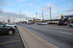
Toco Hills, a de facto commercial center for several CDPs north of the city of Decatur, has grown from a country store in 1950, with a single gas pump and a pot-bellied stove, to multiple shopping centers, coffee houses, houses of worship and townhouses.
North Decatur primarily consists of 1950s and 1960s-era ranch homes, although condominiums are increasingly being developed in this community. Its proximity to Atlanta's Midtown and Buckhead districts, as well as Emory University and Decatur, makes it a desirable "in-town" location for what was originally developed as a suburban community.
Neighborhoods
Clairmont Heights. Located roughly between North Decatur Rd, Clairmont Rd, Mason Mill Park, and Willivee Dr.
Country Squire Court. Located off of Pangborn Rd., SE of the railroad tracks.
Druid Lake. New upscale neighborhood off North Druid Hills Rd., surrounded by North Druid Valley.
Leafmore-Creek Park Hills. Neighborhood located between North Druid Hills Rd., Clairmont Rd., LaVista Rd. & the railroad tracks
Medlock Park. The neighborhood located north of North Decatur Rd., east of Scott Blvd. and west of Clairmont Rd., around the DeKalb County park of the same name.
North Druid Valley. Small neighborhood centered on Homewood Court, south of North Druid Hills Rd.
North Druid Woods. Large neighborhood NW of the intersection of North Druid Hills Rds. & Lawrenceville Hwy.
Ridgeland Park. Located between North Decatur Rd. and Decatur's city limits.
Springdale Heights. Located off of Sycamore Heights in the Decatur Heights community.
Tuxworth Springs. A condo complex off of Scott Blvd.
University Heights. Neighborhood located north of North Decatur Rd. around Willivee.
Valley Brook Estates. Neighborhood between Lawrenceville Highway & Stone Mountain Freeway, near East Ponce de Leon, & off McLendon.
North Decatur, Georgia – racial and ethnic composition Note: the US Census treats Hispanic/Latino as an ethnic category. This table excludes Latinos from the racial categories and assigns them to a separate category. Hispanics/Latinos may be of any race.
As of the 2020 United States census, there were 18,511 people, 8,169 households, and 3,518 families residing in the CDP.
Education
DeKalb County Schools serves the CDP.[22] Some residents are zoned to Laurel Ridge Elementary School, while other residents are zoned to Fernbank Elementary School; both are in the North Decatur CDP.[23] Residents zoned to Laurel Ridge and Fernbank are also zoned to Druid Hills Middle School (in the North Decatur CDP[23]) and Druid Hills High School (in the Druid Hills CDP[24]).[25]
Parks
Clyde Shepherd Nature Preserve, 2580 Pine Bluff Dr. A nature preserve between Medlock Park, University Heights and the Medlock neighborhood.
Mason Mill Park, 1340 McConnell Dr. 111-acre (0.45km2) DeKalb County park with tennis courts, recreation center, picnic area and trails. Also view the ruins of the 1906 Decatur Waterworks, used by the City of Decatur as a drinking water source until the 1940s.
Medlock Park, 874 Gaylemont Cir. 39 acres (160,000m2) Dekalb County park with baseball & softball fields, multi-use field, multi-use court, playground, swimming pool and picnic area.
Transportation
LaVista Road. Northern boundary of North Decatur CDP.
Lawrenceville Highway. Primary access from Interstate 285, and the eastern boundary of the North Decatur CDP.
North Decatur Rd. Primary E-W road providing access from Emory University.
North Druid Hills Rd. Primary NW-SE road that provides access from Interstate 85 and Stone Mountain Freeway, respectively.
Churches
Clairmont Hills Baptist Church -- Replanted as Bridgepoint Church at Toco Hills (Great Commission Baptist), 1995 Clairmont Rd.
North Decatur United Methodist Church (UMC), 1523 Church St.
North Decatur Presbyterian Church (PCUSA), 611 Medlock Rd.
This page is based on this Wikipedia article Text is available under the CC BY-SA 4.0 license; additional terms may apply. Images, videos and audio are available under their respective licenses.