Cold Spring is a village in the town of Philipstown in Putnam County, New York, United States. The population was 1,986 at the 2020 census. It borders the smaller village of Nelsonville and the hamlets of Garrison and North Highlands. The central area of the village is on the National Register of Historic Places as the Cold Spring Historic District due to its many well-preserved 19th-century buildings, constructed to accommodate workers at the nearby West Point Foundry. The town is the birthplace of General Gouverneur K. Warren, who was an important figure in the Union Army during the Civil War. The village, located in the Hudson Highlands, sits at the deepest point of the Hudson River, directly across from West Point. Cold Spring serves as a weekend getaway for many residents of New York City.

F.D. Roosevelt State Park is a 9,049 acres (36.62 km2) Georgia state park located near Pine Mountain and Warm Springs. The park is named for former U.S. President Franklin Delano Roosevelt, who sought a treatment for his paralytic illness in nearby Warm Springs at the Little White House. The park is located along the Pine Mountain Range. The western portion of the park, formerly named Pine Mountain State Park, was named a National Historic Landmark in 1997. F.D. Roosevelt State Park is Georgia's largest state park.

Backbone State Park is Iowa's oldest state park, dedicated in 1919. Located in the valley of the Maquoketa River, it is approximately three miles (5 km) south of Strawberry Point in Delaware County. It is named for a narrow and steep ridge of bedrock carved by a loop of the Maquoketa River originally known as the Devil's Backbone. The initial 1,200 acres (490 ha) were donated by E.M. Carr of Lamont, Iowa. Backbone Lake Dam, a relatively low dam built by the Civilian Conservation Corps (CCC) in the 1930s, created Backbone Lake. The CCC constructed a majority of trails and buildings which make up the park.

Pine Meer, built in 1922–1924, is a historic site located in Green Township, Hamilton County, Ohio, United States. It received national exposure when it was the subject of a reality series that aired on TBS in late 2004 known as The Mansion. In reference to the original owners, the property is known locally as the "Schott Estate." Its address is 5336 Cleves Warsaw Road, Cincinnati, Ohio.

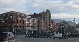
Rutland Downtown Historic District, is the center of government for Rutland, Vermont. The sector of "downtown" is roughly defined as the area between Strongs Avenue, State, Wales, Washington, Pine, and Cottage Streets. The area is also a major center for business, and is considered the most cultural part of Rutland. Much of the area is also listed on the National Register of Historic Places as a historic district and includes 90 contributing properties. Some of these buildings date to the late 18th century, when Rutland was founded, but the greatest amount of expansion in downtown came after the marble industry became established on a large scale after 1850. The city's population tripled between 1850 and 1880, and many of the buildings built in this period were either built with or ornamented with marble.

The Spring Hill Historic District encompasses a rural 19th-century village stretching along Storrs Road in Mansfield, Connecticut. Spring Hill developed as a rural waystation on an early 19th-century turnpike, and has seen only modest development since the late 19th century. The district was listed on the National Register of Historic Places in 1979.

The Beech Hill Summer Home District encompasses a collection of six early 20th century summer houses in Harrisville, New Hampshire, built on a ridge overlooking Dublin Pond with views of nearby Mount Monadnock. The properties, a number of which were built for members of the Thayer family, lie on Mason Road, just north of the town line with Dublin. The most significant property of the six is the 140-acre (57 ha) Skyfield estate, whose large Georgian Revival mansion was designed by Lois Lilley Howe and built in 1916. The district is also notable as containing archaeological remnants of 18th century farmsteads, for which reason its properties are also listed in the Harrisville Rural District. The district was listed on the National Register of Historic Places in 1988.

The Scott Farm Historic District encompasses a historic farm property at 707 Kipling Road in Dummerston, Vermont. Developed between about 1850 and 1915, Scott Farm is a well-preserved farm and orchard complex of that period. It was listed on the National Register of Historic Places in 2001.

The Vernon District Schoolhouse No. 4 is a historic school building at 4201 Fort Bridgman Road in Vernon, Vermont. Built 1848, it is a well-preserved mid-19th century brick district school, which now serves as a local historical museum. It was listed on the National Register of Historic Places in 2005.

The Middletown Springs Historic District encompasses most of the village center of Middletown Springs, Vermont. Oriented around the crossroads junction of Vermont Routes 140 and 133, the village has a well-preserved collection of mainly mid-19th century architecture, including a significant number of Italianate buildings. The district was listed on the National Register of Historic Places in 1985.

The Brookfield Village Historic District encompasses the 19th-century village center of Brookfield, Vermont. Arrayed on the eastern shore of Sunset Lake, it includes well-preserved examples of Greek Revival architecture, and is best known for the Sunset Lake Floating Bridge, a pontoon bridge that provides access to the village from the west. It was listed on the National Register of Historic Places in 1974.

The Randolph Center Historic District encompasses the historic early town center of Randolph, Vermont. Established in 1783, it was later eclipsed by Randolph Village, which developed around the town's main railroad depot. The village now has a distinguished array of late 18th and early 19th-century architecture and is home to an academic campus now housing Vermont State University. It was listed on the National Register of Historic Places in 1974.

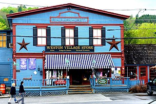
The Weston Village Historic District encompasses the town center and principal village of Weston, Vermont. Centered on Farrar Park, which serves as the town green, it includes a diversity of architectural styles from the late 18th century to about 1935, and includes residential, civic, commercial, industrial and religious buildings. It was listed on the National Register of Historic Places in 1985.
Sutton Farm is a historic farm property at 4592 Dorset Road in Shelburne, Vermont. Established in 1788, the farm was operated continuously into the late 20th century by a single family, and includes a well-preserved Greek Revival farmhouse. It was listed on the National Register of Historic Places in 2004.

The Darling Estate Historic Estate encompasses an historic country estate of more than 2,000 acres (810 ha) on Darling Hill Road, straddling the town line between Burke and Lyndon, Vermont. Built in the early 1900s for Elmer Darling, a locally-born New York hotelier, it was one of Vermont's largest such estates, featuring Burklyn Hall, one of its most opulent Colonial Revival houses, as well as numerous 19th-century farm properties. It was listed on the National Register of Historic Places in 2011.
The Pine Street Industrial Historic District encompasses a collection of maritime industrial buildings and archaeological sites in southern Burlington, Vermont. The district includes buildings across nearly 100 years, encompassing the development and decline of the area, which served as a major railroad and shipping terminus from the mid-19th to mid-20th centuries. It was listed on the National Register of Historic Places in 1984.
The Meeting House Farm is a historic farm property at 128 Union Village Road in Norwich, Vermont. Encompassing more than 90 acres (36 ha) of woodlands and pasture, the farm has more than 200 years of architectural history, including a late 18th-century farmhouse and an early 19th-century barn. The property was listed on the National Register of Historic Places in 2020.
The Brigham Hill Historic District encompasses a rural 19th-century landscape in central Norwich, Vermont. It includes three late 18th or early 19th century farmsteads, all associated with the Brigham family, whose progenitor, Paul Brigham, was prominent in Vermont politics. It was listed on the National Register of Historic Places in 2020.
The Walter and Sylvia Stockmayer House is a historic house at 48 Overlook Drive in Norwich, Vermont. Built in 1961 to a design by Allan Gelbin, it is one of the town's finer examplers of Usonian Mid-Century Modern architecture, a style espoused by Frank Lloyd Wright that is also relatively rare in the state. It was listed in the National Register of Historic Places in 2020.


