
White River Junction is an unincorporated village and census-designated place (CDP) in the town of Hartford in Windsor County, Vermont, United States. The population was 2,528 at the 2020 census, up from 2,286 in 2010, making it the largest community within the town of Hartford.

Wilder is an unincorporated village and census-designated place (CDP) within the town of Hartford in Windsor County, Vermont, United States. It is the location of the Wilder Dam on the Connecticut River. The population of the CDP was 1,690 at the 2010 census. The village center is an early example of a planned mill community, and was listed on the National Register of Historic Places as the Wilder Village Historic District in 1999.

West Hartford is an unincorporated community village in the town of Hartford, Windsor County, Vermont. It is the most rural of Hartford's five villages, situated on the White River and crossed by the Appalachian Trail. Almost half of the village was wiped out by a flood in 1927. Some areas have been developed for residential use but significant forest, farming and open lands remain. West Hartford features a country store, a post office, many shops, a small library and a town park along the White River, which is also a popular fishing site. The village center is listed on the National Register of Historic Places as the West Hartford Village Historic District.

Hartford is one of five unincorporated villages in the town of Hartford, Windsor County, Vermont, United States. It is also referred to as Hartford Village. For the 2020 census it was listed as a census-designated place, with a population of 754, out of 10,686 in the entire town of Hartford.

Melrose is a rural village in northeastern East Windsor, Connecticut. Centered at the crossroads of Broad Brook Road and Melrose Road, it was settled in the 1700s and developed as an agrarian village center in the 19th century. A landscape of more than 250 acres (100 ha), including farmland, period farmhouses, ruins of a small distillery, and a district schoolhouse was listed on the National Register of Historic Places in 2010.

The Hotchkissville Historic District is a historic district in the town of Woodbury, Connecticut, that was listed on the National Register of Historic Places in 1995. The district encompasses most of the historic village of Hotchkissville, which is centered at the junction of Washington and Weekeepeemee roads. The village began as a dispersed rural agricultural community, but developed in the 19th century with the arrival of industry, primarily the manufacture of textiles. Despite this, the village has retained a significantly rural character, and includes a broad cross-section of 18th- and 19th-century architectural styles.

White River Junction Historic District is a historic district in the unincorporated village of White River Junction, within the town of Hartford, Vermont. It was first listed on the National Register of Historic Places in 1980, and its boundaries were increased in 2002 and 2019. It originally encompassed the central portion of the village's business district, and was then expanded to include a broader array of resources.

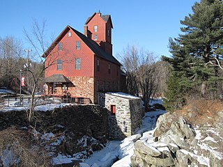
The Taftsville Historic District encompasses a historic 19th-century industrial village that is mostly in Woodstock, Vermont. Flanking the Ottauquechee River and extending up Happy Valley Road, the area developed around a metal tool factory established by members of the Taft family in 1793. Important elements from its early history include the Taftsville Store, built by the Taft family in 1840, and the Taftsville Covered Bridge, built in 1836. The district was listed on the National Register of Historic Places in 2001.
The East Weatogue Historic District is a 490-acre (200 ha) historic district in the town of Simsbury, Connecticut that was listed on the National Register of Historic Places in 1990. It then included 102 contributing buildings, 10 contributing sites, 11 contributing structures, and one other contributing object. The district encompasses a largely agrarian rural village centered at the junction of Hartford Road and East Weatogue Street, whose early development dates to the late 17th century, with the oldest surviving buildings dating to 1730. Most of the properties in the district are Colonial, Federal, or Greek Revival in character, with only a few later Victorian houses. In the early 20th century Colonial Revival houses sympathetic to the earlier buildings.

The Houghtonville Historic District encompasses a cluster of residential properties that are all that remain of one of the early industrial areas of Grafton, Vermont. Located west of Grafton Village on Houghtonville Road, it includes ten well-preserved 19th-century houses, some located on properties where early mills once stood. The district was listed on the National Register of Historic Places in 2015.
The Middletown Rural Historic District encompasses an area that was once the town center of Grafton, Vermont. Located northwest of Grafton Village along Middletown Road and adjacent roads, it includes nine well-preserved 19th-century properties, as well as the town's first cemetery and animal pound. The district was listed on the National Register of Historic Places in 2011.

The Middletown Springs Historic District encompasses most of the village center of Middletown Springs, Vermont. Oriented around the crossroads junction of Vermont Routes 140 and 133, the village has a well-preserved collection of mainly mid-19th century architecture, including a significant number of Italianate buildings. The district was listed on the National Register of Historic Places in 1985.
The Jericho Rural Historic District encompasses a rural agricultural landscape of northern Hartford, Vermont, extending slightly into neighboring Norwich. The area covers 774 acres (313 ha) of mainly agricultural and formerly agricultural lands, as well as associated woodlots, and includes nine historically significant farm complexes. It was listed on the National Register of Historic Places in 2001.

The Oxbow Historic District encompasses a well-preserved rural agricultural area on United States Route 5 in northern Newbury, Vermont. It was one of the first areas to be settled in the town, and includes seven agricultural properties, with six farmhouses built before 1835 and a number of surviving 19th-century farm outbuildings. It was listed on the National Register of Historic Places in 1983.

The South Newbury Village Historic District encompasses the surviving elements of a small industrial village in southern Newbury, Vermont. It includes five residences and several outbuildings, most of which are agricultural in character, representing the area's shift in use in the 20th century. The district was listed on the National Register of Historic Places in 1983.
The Jericho Village Historic District encompasses the historic industrial and commercial center of the village of Jericho, Vermont. Stretched along Vermont Route 15 south of Browns River, which powered the village's industries for many years, the village center includes a well-preserved array of 19th and early 20th-century buildings. The district was listed on the National Register of Historic Places in 1992.

The Warren Village Historic District encompasses the village center of Warren, Vermont. Stretched mainly along Main Street east of the Mad River, it is a well-preserved 19th-century mill village, although most of its period mill infrastructure has been lost. The district has good examples of Greek Revival, Italianate, and Second Empire architecture. It was listed on the National Register of Historic Places in 1992.

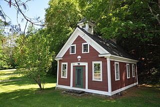
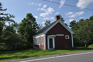
The Hastings Hill Historic District encompasses a rural crossroads settlement of the early 19th century at the junction of Spruce Street, Hill Street, and Russell Avenue in Suffield, Connecticut. The area includes well-preserved examples of 18th and 18th-century domestic architecture, as well as the 1842 First Baptist Church and a district schoolhouse. It was listed on the National Register of Historic Places in 1979.

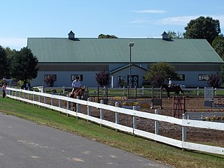
The Advent Camp Meeting Ground Historic District encompasses the early surviving elements of a religious summer camp meeting ground in Hartford, Vermont. Founded in 1887, it is one of a small number of camp meetings surviving from the 19th century in the state, and the only surviving one run by the Advent Christian General Conference. It was listed on the National Register of Historic Places in 2017.
The Goodrich Four Corners Historic District encompasses a rural 19th-century village center in rural northern Norwich, Vermont. The village arose in the late 18th century, settled by the son of one of Norwich's early proprietors. The district has well-preserved examples of architecture ranging from the late 18th century to the early 20th century. It was listed on the National Register of Historic Places in 2019.


